| 0 | PI 495872 | 2A | Alnus incana (L.) Moench subsp. tenuifolia (Nutt.) Breitung | Colorado, United States | NC7 | | | 1984 | COLLECTED | | Aspen Glen area, Fall River entrance, Rocky Mountain Natl. P ark, Colorado | | 2553 | | Wild material | Tree small, growing in wet meadow. Seeds not fully mature. | 1390808 | PI 495872 |
| 1 | PI 495873 | 6A | Alnus incana (L.) Moench subsp. tenuifolia (Nutt.) Breitung | Colorado, United States | NC7 | | | 1984 | COLLECTED | | Chasm Falls Picnic area, Fall River Rd. cut-off, Rocky Mt. N atl. Park, CO | 40.41685900, -105.67232400 | 2703 | | Wild material | Tree deciduous, along stream bed with engelmann spruce and redberried elder. Seed from one plant. | 1390809 | PI 495873 |
| 2 | PI 495874 | 9A | Alnus incana (L.) Moench subsp. tenuifolia (Nutt.) Breitung | Colorado, United States | NC7 | | | 1984 | COLLECTED | | Near Timber Creek campground, W gate of Rocky Mt. Natl. Park , Grand Co, CO | 40.37970300, -105.85338500 | 2613 | | Wild material | Single small deciduous tree in drainage area along road. Foliage dark green with no leaf miners. | 1390810 | PI 495874 |
| 3 | PI 495875 | 14A | Alnus incana (L.) Moench subsp. tenuifolia (Nutt.) Breitung | Colorado, United States | NC7 | | | 1984 | COLLECTED | | Along stream bed on way to city reservoir, W end of Kremmlin g, Colorado | | 2211 | | Wild material | Single small heavily fruited deciduous tree. Some leaf miner present. | 1390811 | PI 495875 |
| 4 | W6 43991 | AK930-317 | Alnus incana (L.) Moench subsp. tenuifolia (Nutt.) Breitung | Alaska, United States | W6 |  | | 2012 | | | | | | | Wild material | | 1900460 | W6 43991 |
| 5 | PI 635454 | H. lupulus var. neomexicanus OCJ-29 | Humulus lupulus L. var. neomexicanus A. Nelson & Cockerell | Colorado, United States | COR | | | 2002 | COLLECTED | 09/14/2002 | North from Interstate 70 on Colorado River Road, take County Road 150 to Sweetwater Lake. About one half mile past upper end of lake along road side. | 39.81028000, -107.18222000 | 2366 | Raparian; Alnus tenuifolia, Prunus virginiana, Salix sp. and Ribes sp. | Wild material | | 1642213 | PI 635454 |
| 6 | PI 635455 | H. lupulus var. neomexicanus OCJ-30 | Humulus lupulus L. var. neomexicanus A. Nelson & Cockerell | Colorado, United States | COR | | | 2002 | COLLECTED | 09/14/2002 | North from Interstate 70 on Colorado River Road, take County Road 150 to Sweetwater Lake. Just past the upper end of lake along road. | 39.81028000, -107.17111000 | 2363 | Raparian; Alnus tenuifolia, Prunus virginiana and Salix sp. | Wild material | | 1642214 | PI 635455 |
| 7 | W6 62345 | AK930-1169 | Calamagrostis canadensis (Michx.) P. Beauv. | Alaska, United States | W6 | | | 2025 | | | | | | | Wild material | NA | 2172699 | W6 62345 |
| 8 | W6 62346 | AK930-1170 | Chamaenerion angustifolium (L.) Scop. subsp. angustifolium | Alaska, United States | W6 | | | 2025 | | | | | | | Wild material | NA | 2172700 | W6 62346 |
| 9 | W6 62367 | AK930-1191 | Saxifraga tricuspidata Rottb. | Alaska, United States | W6 | | | 2025 | | | | | | | Wild material | NA | 2172721 | W6 62367 |
| 10 | W6 62368 | AK930-1192 | Elymus trachycaulus (Link) Gould subsp. trachycaulus | Alaska, United States | W6 | | | 2025 | | | | | | | Wild material | NA | 2172722 | W6 62368 |
| 11 | W6 62381 | AK930-1208 | Dryas drummondii Richardson ex Hook. | Alaska, United States | W6 | | | 2025 | | | | | | | Wild material | RECOLLECTION of AK930-874 flowers nodding filaments hairy | 2172735 | W6 62381 |
| 12 | WLP 3092 | RJLSEUS2022-021 | Rhododendron prunifolium (Small) Millais | Alabama, United States | NA | | | 2023 | COLLECTED | 12/10/2023 | Slopes along Poke Springs Branch inlet accessed by boat from Walter F. George Reservoir. Generally uncommon, but frequent at this site. | 31.72318400, -85.12907800 | 69 | Plants are growing in part-shade to shade on the well-drained mostly deciduous woodland slopes approximately 3-6 meters above the inlet.
Soils: The underlying geology of this area is of Cretaceous origin and characterized as Selma Group; Providence Sand. The upper part of the profile consists of cross-bedded fine to coarse sand and white, dark-gray and pale-red-purple mottled clay containing lignite, sand, and kaolin. The lower part consists of dark-gray laminated to thin-bedded silty clay and abundantly micaceous, carbonaceous, fossiliferous very fine to fine sand.
Source: USGS Alabama Geologic Map Data (https://mrdata.usgs.gov/geology/state/sgmc-unit.php?unit=ALKp%3B1)
The primary soil types in the collection area are classified as Nankin-Lucy Complex soil (20 to 60 percent slopes). The Nankin Series consists of very deep, well drained, moderately slowly permeable soils on uplands of the Coastal Plain. They formed in stratified loamy and clayey marine sediments. Slopes range from 0 to 60 percent. Soils are comprised of sandy loam in the upper 25 cm to sandy clay loam and sandy clay in lower strata to about 1.7 meters deep; these soils are strongly acid. The Lucy Series consists of very deep, well drained, moderately permeable soils on uplands. They formed in sandy and loamy marine and fluvial sediments of the Southern Coastal Plain. Slopes vary from 0 to 45 percent. These soils are generally loamy to sandy loam in the upper 25 cm and sandy clay loam in the lower strata to 2 meters; these are strongly acid soils.
Source: NRCS Web Soil Survey (https://websoilsurvey.sc.egov.usda.gov/App/WebSoilSurvey.aspx) | Wild material | | 2141446 | WLP 3092 |
| 13 | W6 56090 | AK930-686 | Carex capillaris L. | Alaska, United States | W6 |  | | 2019 | | | | | | | Wild material | | 1975831 | W6 56090 |
| 14 | OPGC 7377 | AK930-685 | Gentianella propinqua (Richardson) J. M. Gillett | Alaska, United States | OPGC |  | | 2019 | | | | | | | Wild material | | 1975830 | OPGC 7377 |
| 15 | W6 48958 | AK930-486 | Calamagrostis canadensis (Michx.) P. Beauv. | Alaska, United States | W6 |  | | 2015 | | | | | | | Wild material | | 1923873 | W6 48958 |
| 16 | W6 48959 | AK930-487 | Koenigia alpina (All.) T. M. Schust. & Reveal | Alaska, United States | W6 |  | | 2015 | | | | | | | Wild material | | 1923874 | W6 48959 |
| 17 | WLP 2114 | 302003 | Baccharis halimifolia L. | Virginia, United States | NA |  | | 2008 | COLLECTED | 10/18/2005 | | | 6 | Slope: 0 Aspect: NE Soil: Sandy-clay, Land form: Wetland. Mowed. | Wild material | | 1780137 | WLP 2114 |
| 18 | Ames 29890 | 172417 | Cornus sericea L. | Colorado, United States | NC7 |  | | 2005 | COLLECTED | 08/08/2002 | Colorado Rocky Mountains. Grand County. Corral Creek. | 40.07750000, -106.18583000 | 2325 | Montane riparian community. | Wild material | Shrub 1.2-1.5 meters tall. | 1673920 | Ames 29890 |
| 19 | OPGC 3020 | 178224 | Rudbeckia laciniata L. var. ampla (A. Nelson) Cronquist | Colorado, United States | OPGC |  | | 2005 | COLLECTED | 09/27/2002 | | | 2255 | Streambank - montane riparian community. Associated with Alnus tenuifolia, Cornus sericea, Ribes sp., Rubus sp., Salix sp. | Wild material | Forb 1-2 meters tall. | 1674037 | OPGC 3020 |
| 20 | WLP 2310 | 176806 | Rosa woodsii Lindl. | Colorado, United States | NA | 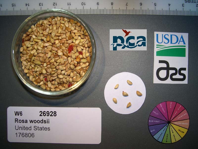 | | 2005 | COLLECTED | 08/05/2002 | | | 2255 | Stream bank; montane riparian community; soil very dark greyish-brown sand-silt.Montane riparian community. | Wild material | Shrub 0.9-2 meters tall. | 1673967 | WLP 2310 |