| 0 | PI 710511 | CBG-9428 | Apocynum cannabinum L. | Illinois, United States | S9 |  | | 2019 | | | | | | | Wild material | | 2092802 | PI 710511 |
| 1 | PI 710510 | NM018-72 | Apocynum cannabinum L. | New Mexico, United States | S9 |  | | 2017 | | | | | | | Wild material | | 1949760 | PI 710510 |
| 2 | PI 710509 | MARSB-029 | Apocynum cannabinum L. | Maryland, United States | S9 |  | | 2015 | | | | | | | Wild material | | 1922831 | PI 710509 |
| 3 | PI 710508 | UT080-113 | Apocynum cannabinum L. | Utah, United States | S9 |  | | 2014 | | | | | | | Wild material | | 1916795 | PI 710508 |
| 4 | PI 710507 | NV030-285 | Apocynum cannabinum L. | Nevada, United States | S9 |  | | 2010 | | | | | | | Wild material | | 1833707 | PI 710507 |
| 5 | PI 710506 | NV030-239 | Apocynum cannabinum L. | Nevada, United States | S9 |  | | 2009 | | | | | | | Wild material | 1-2m tall shrub with long, slender pods. | 1808199 | PI 710506 |
| 6 | PI 710505 | NV030-207 | Apocynum cannabinum L. | Nevada, United States | S9 |  | | 2009 | | | | | | | Wild material | | 1802239 | PI 710505 |
| 7 | OPGC 8365 | CA170-255 | Apocynum cannabinum L. | California, United States | OPGC | | | 2021 | | | | | | | Wild material | Perennial forb with white flowers and opposite petioled leaves; milky latex; fruits are pairs of long slender capsules that dehisce and release wind dispersed seeds at maturity. | 2120350 | OPGC 8365 |
| 8 | OPGC 8162 | MARSB-765 | Apocynum cannabinum L. | New Jersey, United States | OPGC | | | 2021 | | | | | | | Wild material | Flower petal colorûgreen to brownûwhiteûyellowûLeaf typeûthe leaves are simple (i.e., lobed or unlobed but not separated into leaflets)ûLeaf arrangementûopposite: there are two leaves per node along the stemûLeaf blade edgesûthe edge of the leaf blade is entire (has no teeth or lobes)ûFlower symmetryûthere are two or more ways to evenly divide the flower (the flower is radially symmetrical)ûNumber of sepals, petals or tepalsûthere are five petals, sepals, or tepals in the flowerûFusion of sepals and petalsûthe petals or the sepals are fused into a cup or tubeûStamen numberû5ûFruit type (general)ûthe fruit is dry and splits open when ripeûFruit lengthû50–200 mm | 2113611 | OPGC 8162 |
| 9 | OPGC 7907 | MARSB-518 | Apocynum cannabinum L. | New Jersey, United States | OPGC |  | | 2019 | | | | | | | Wild material | | 2097644 | OPGC 7907 |
| 10 | OPGC 2072 | HP-11 | Apocynum cannabinum L. | Ohio, United States | OPGC | | | 2004 | COLLECTED | 11/10/2004 | Hunter Prairie, intersection of Ohio Routes 92 and 148, Belmont County | 39.92444444, -81.06250000 | | | Wild material | | 1690722 | OPGC 2072 |
| 11 | OPGC 1926 | ALP 16 | Apocynum cannabinum L. | Ohio, United States | OPGC | | | 2004 | COLLECTED | 10/07/2004 | Adams Lake Prairie State Nature Preserve, within Adams Lake State Park, Adams County | 38.81083333, -83.53027778 | | Prairie remnant. Sun. Slope: Slight. | Wild material | 1-3'. Sample size: 5. Population size: 10. Site size (sqm): 5. | 1690588 | OPGC 1926 |
| 12 | PI 664640 | 205300 | Helianthus nuttallii Torr. & A. Gray subsp. nuttallii | California, United States | NC7 | 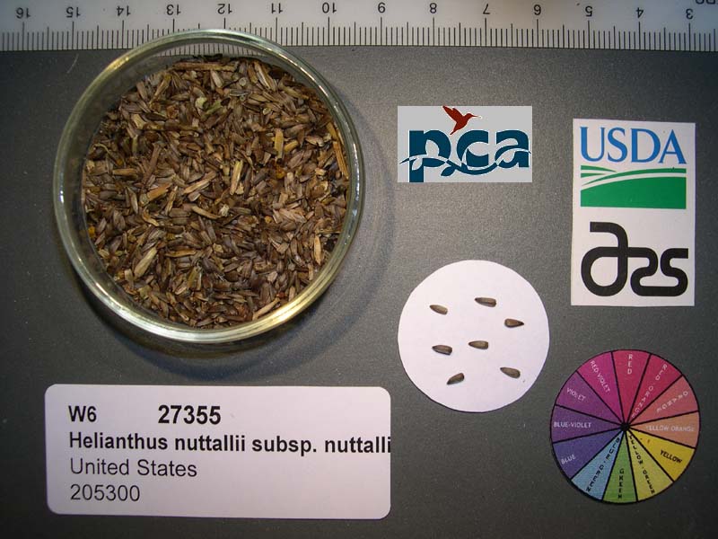 | | 2005 | COLLECTED | 10/10/2003 | Fish Slough along Eastside Rd at BLM spring, Inyo County | | 1275 | Alkali wetland. Associated with Phragmites australis, Sporobolis airoides, Solidago spectabilis, Apocynum cannabinum and Asclepias speciosa. | Wild material | Forb 1.5-2.4 meters tall; large population | 1674386 | PI 664640 |
| 13 | W6 62525 | FWS0300-125 | Lysimachia quadriflora Sims | Michigan, United States | W6 |  | | 2025 | | | | | | | Wild material | | 2192223 | W6 62525 |
| 14 | W6 62534 | FWS0300-144 | Solidago riddellii Frank | Michigan, United States | W6 |  | | 2025 | | | | | | | Wild material | The vegetative part of the population is likely dormant, though it is not possible to discern dormant individuals. Consequently, the above population size may be an underestimate. | 2192232 | W6 62534 |
| 15 | W6 62544 | FWS0300-78 | Schoenoplectus tabernaemontani (C. C. Gmel.) Palla | Michigan, United States | W6 |  | | 2025 | | | | | | | Wild material | Plants have variable phenology with mature achenes and fresh flowers often on a single individual | 2192242 | W6 62544 |
| 16 | W6 62549 | FWS0502-100 | Verbena hastata L. | Pennsylvania, United States | W6 |  | | 2025 | | | | | | | Wild material | Many in course rocky drainage area by bridge | 2192247 | W6 62549 |
| 17 | W6 62558 | FWS0502-80 | Eutrochium fistulosum (Barratt) E. E. Lamont | Pennsylvania, United States | W6 |  | | 2025 | | | | | | | Wild material | SCOUTING ID CHANGE. Ripe plants mostly withered but whorled leaves still hanging on | 2192256 | W6 62558 |
| 18 | NA 87842 | TRX241117-08SC | Ilex opaca Aiton | South Carolina, United States | NA | | | 2024 | COLLECTED | 11/17/2024 | Francis Marion National Forest. | 33.15167000, -79.60253000 | 31 | | Wild material | | 2169895 | NA 87842 |
| 19 | Ames 36255 | Kothenbeutel Prairie | Delphinium carolinianum Walter subsp. virescens (Nutt.) R. E. Brooks | Iowa, United States | NC7 | 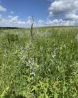 | | 2024 | COLLECTED | 07/08/2024 | Kothenbeutel Prairie Preserve located approximately 4.24 miles east, southeast of Sheffield just north of 240th Street, T93 R19W SW 1/4 SE 1/4 Sec. 7. | 42.87887400, -93.13261500 | 332 | Prairie remnant on south and southwestern aspects of 15-25 degree slopes. | Wild material | Plants in nature measuring approximately 30-38" in height. | 2168178 | Ames 36255 |
| 20 | NA 88716 | RJL2023NCSC-021 | Ilex myrtifolia Walter | South Carolina, United States | NA | | | 2023 | COLLECTED | 11/14/2023 | Francis Marion National Forest: plants growing in a pond cypress-water tupelo swamp on the west side of Thompson Branch Road just south of the junction with Round Pond Road B. | 33.15167800, -79.60253700 | 31 | Plants are growing in part-shade to shade as understory trees among the pond cypress-water tupelo forest throughout the acid swamp which is seasonally inundated. The overstory is largely deciduous and comprised of pond cypress and water tupelo, while the understory is a mix of evergreen and deciduous broadleaved shrubs and understory trees. Slope: N/A. Aspect: N/A. The underlying geology of this area is of Pleistocene origin and characterized as a Socastee Formation. This is a low coastal formation in the Carolinas like Penholoway but younger and lower in altitude. It is comprised primarily of unconsolidated, fine-detrital clay. It is described as variegated quartzose sands, argillaceous sands, and clays, 5 m thick at the type section near Socastee Swamp. (Source: USGS South Carolina Geologic Map Data.) The primary soil type in this collection area is classified as Pickney Series loamy fine sand. The Pickney Series consists of very deep, very poorly drained, persistently wet, permeable soils that formed from marine or fluvial sediments. Slopes range from 0 to 2 percent. The upper strata soil, 0-75 cm, is black loamy fine sand that is very friable and extremely acid. The lower strata, 75-120 cm is dark gray fine sand with occasional white mottling, loose, and moderately acid. (Source: NRCS Web Soil Survey.) | Wild material | | 2159144 | NA 88716 |
| 21 | NA 88717 | RJL2023NCSC-022 | Ilex opaca Aiton | South Carolina, United States | NA | | | 2023 | COLLECTED | 11/14/2023 | Francis Marion National Forest: plants growing in a pond cypress-water tupelo swamp on the west side of Thompson Branch Road just south of the junction with Round Pond Road B. | 33.15161300, -79.60217900 | 22 | Plants are growing in part-shade to shade as understory trees among the pond cypress-water tupelo forest, mostly along the edges of the acid swamp which is seasonally inundated. The overstory is largely deciduous and comprised of pond cypress and water tupelo, while the understory is a mix of evergreen and deciduous broadleaved shrubs and understory trees. Slope: N/A. Aspect: N/A. The underlying geology of this area is of Pleistocene origin and characterized as a Socastee Formation. This is a low coastal formation in the Carolinas like Penholoway but younger and lower in altitude. It is comprised primarily of unconsolidated, fine-detrital clay. It is described as variegated quartzose sands, argillaceous sands, and clays, 5 m thick at the type section near Socastee Swamp. (Source: USGS South Carolina Geologic Map Data.) The primary soil type in this collection area is classified as Pickney Series loamy fine sand. The Pickney Series consists of very deep, very poorly drained, persistently wet, permeable soils that formed from marine or fluvial sediments. Slopes range from 0 to 2 percent. The upper strata soil, 0-75 cm, is black loamy fine sand that is very friable and extremely acid. The lower strata, 75-120 cm is dark gray fine sand with occasional white mottling, loose, and moderately acid. (Source: NRCS Web Soil Survey.) | Wild material | | 2159145 | NA 88717 |
| 22 | Ames 36209 | JDC/EM/2023/089/1121 | Eutrochium maculatum (L.) E. E. Lamont | Iowa, United States | NC7 | | | 2023 | COLLECTED | 10/19/2023 | Located approximately 3.15 miles west of Grinnell, T80N R17W SE 1/4 SE 1/4 NE 1/4 Sec. 14. | 41.73894000, -92.78670000 | 271 | Wet, remnant prairie. | Wild material | Plants in nature at collection site measuring approximately 3.5-5.0 feet in height. | 2165627 | Ames 36209 |
| 23 | W6 61362 | CBG- 10777 | Drymocallis arguta (Pursh) Rydb. | Illinois, United States | W6 |  | | 2023 | | | | | | | Wild material | | 2142244 | W6 61362 |
| 24 | W6 61387 | CBG- 10812 | Chamaecrista fasciculata (Michx.) Greene | Illinois, United States | W6 |  | | 2023 | | | | | | | Wild material | | 2142269 | W6 61387 |
| 25 | W6 61395 | CBG- 10823 | Helianthus mollis Lam. | Illinois, United States | W6 |  | | 2023 | | | | | | | Wild material | | 2142277 | W6 61395 |
| 26 | W6 61398 | CBG- 10826 | Helianthus pauciflorus Nutt. | Illinois, United States | W6 |  | | 2023 | | | | | | | Wild material | | 2142280 | W6 61398 |
| 27 | NA 89047 | RJL2022PA-015 | Cephalanthus occidentalis L. | Pennsylvania, United States | NA | | | 2022 | COLLECTED | 10/09/2022 | Plants growing in the floodplain of Octoraro Creek near 698 Lees Bridge Road, West Nottingham Township, Pennsylvania on the south side of the road. Plants are locally common and spread out in the floodplain area along the Octoraro Creek. | 39.73540700, -76.09226500 | 60 | Plants of this species are growing in full sun to part shade of a moist to seasonally mucky and wide flood plain area adjacent to Octoraro Creek. The area is dominated by deciduous herbaceous plants, scrambling vines, shrubs and occasional small trees. Much of this wet “meadow” is dominated by aggressive stands of grasses and members of the sedge family.
Soils: The underlying geology of this area is estimated to be of lower Paleozoic origin and comprised of Peters Creek Schist. This is comprised of chlorite-sericite schist containing interbedded quartzite. Interestingly, this area is very close to and may interface with the adjacent formation of Ultramafic Rocks that includes serpentine, steatite, and other products of alteration of peridotites and pyroxenites.
Source: USGS Pennsylvania Geologic Map Data (https://mrdata.usgs.gov/geology/state/sgmc-unit.php?unit=PAPZpc%3B0)
The primary soil types in the collection area are classified as Hatboro Silt Loam which consists of soils formed in alluvium derived from metamorphic and crystalline rock. They are on flood plains. Slopes range from 0 to 3 percent. Hatboro Silt Loam soils are poorly drained and have a high to very high surface runoff index. These soils are subject to periodic stream overflow, which usually occurs during the winter and spring months. The A and B horizons are moderately acidic to neutral, generally to a depth of 1-2 meters; the C horizon below ranges from a depth of 2-3 meters with uniformly acidic soils.
Source: NRCS Web Soil Survey (https://websoilsurvey.sc.egov.usda.gov/App/WebSoilSurvey.aspx) | Wild material | | 2139612 | NA 89047 |
| 28 | NA 89046 | RJL2022PA-014 | Alnus serrulata (Aiton) Willd. | Pennsylvania, United States | NA | | | 2022 | COLLECTED | 10/09/2022 | Plants growing in the floodplain of Octoraro Creek near 698 Lees Bridge Road, West Nottingham Township, Pennsylvania on the south side of the road. Plants are locally common and spread out in the floodplain area along the Octoraro Creek. | 39.73579900, -76.09238300 | 60 | Plants of this species are growing in full sun of a moist to seasonally mucky and wide flood plain area adjacent to Octoraro Creek. The area is dominated by deciduous herbaceous plants, scrambling vines, shrubs and occasional small trees. Much of this wet “meadow” is dominated by aggressive stands of grasses and members of the sedge family.
Soils: The underlying geology of this area is estimated to be of lower Paleozoic origin and comprised of Peters Creek Schist. This is comprised of chlorite-sericite schist containing interbedded quartzite. Interestingly, this area is very close to and may interface with the adjacent formation of Ultramafic Rocks that includes serpentine, steatite, and other products of alteration of peridotites and pyroxenites.
Source: USGS Pennsylvania Geologic Map Data (https://mrdata.usgs.gov/geology/state/sgmc-unit.php?unit=PAPZpc%3B0)
The primary soil types in the collection area are classified as Hatboro Silt Loam which consists of soils formed in alluvium derived from metamorphic and crystalline rock. They are on flood plains. Slopes range from 0 to 3 percent. Hatboro Silt Loam soils are poorly drained and have a high to very high surface runoff index. These soils are subject to periodic stream overflow, which usually occurs during the winter and spring months. The A and B horizons are moderately acidic to neutral, generally to a depth of 1-2 meters; the C horizon below ranges from a depth of 2-3 meters with uniformly acidic soils.
Source: NRCS Web Soil Survey (https://websoilsurvey.sc.egov.usda.gov/App/WebSoilSurvey.aspx) | Wild material | | 2139611 | NA 89046 |
| 29 | Ames 35789 | Rossow Prairie | Eupatorium perfoliatum L. | Iowa, United States | NC7 | | | 2022 | COLLECTED | 11/03/2021 | Rossow Prairie located 8.25 miles northeast of Fort Dodge, T89N R27W NE ¼ NE ¼ Sec. 10. | 42.54452000, -94.01109900 | 324 | Remnant sedge meadow, prairie pothole complex. | Wild material | | 2133098 | Ames 35789 |
| 30 | W6 60055 | NCBG-707 | Salvia lyrata L. | North Carolina, United States | W6 | | | 2021 | | | | | | | Wild material | | 2132936 | W6 60055 |
| 31 | W6 60070 | NCBG-754 | Saccharum giganteum (Walter) Pers. | North Carolina, United States | W6 | | | 2021 | | | | | | | Wild material | | 2132951 | W6 60070 |
| 32 | NA 88322 | CBG-10488 | Hypericum adpressum W. P. C. Barton | Illinois, United States | NA | | | 2021 | | | | | | | Wild material | | 2120113 | NA 88322 |
| 33 | OPGC 8317 | CBG-10487 | Ludwigia alternifolia L. | Illinois, United States | OPGC | | | 2021 | | | | | | | Wild material | | 2120112 | OPGC 8317 |
| 34 | W6 59192 | CBG-10486 | Coleataenia rigidula (Bosc ex Nees) LeBlond | Illinois, United States | W6 | | | 2021 | | | | | | | Wild material | | 2120111 | W6 59192 |
| 35 | W6 59035 | NCBG-589 | Sorghastrum nutans (L.) Nash | Virginia, United States | W6 | | | 2021 | | | | | | | Wild material | | 2116351 | W6 59035 |
| 36 | OPGC 8150 | MARSB-547 | Euthamia caroliniana (L.) Greene ex Porter & Britton | New Jersey, United States | OPGC | | | 2021 | | | | | | | Wild material | Leaf typeûleaves are simple (i.e., lobed or unlobed but not separated into leaflets)ûLeaf arrangementûalternate: there is one leaf per node along the stemûLeaf blade edgesûthe edge of the leaf blade has no teeth or lobesûFlower type in flower headsûthe flower head has tubular disk flowers in the center and ray flowers, these often strap-shaped, around the peripheryûRay flower colorûyellowûTuft or plume on fruitûat least a part of the plume is made up of fine bristlesûSpines on plantûthe plant has no spinesûLeaf blade lengthû24–70 mmûDisk flower numberû1-5û11-20û21-50û6-10 | 2113556 | OPGC 8150 |
| 37 | OPGC 8160 | MARSB-763 | Solidago canadensis L. | New Jersey, United States | OPGC | | | 2021 | | | | | | | Wild material | Leaf typeûleaves are simple (i.e., lobed or unlobed but not separated into leaflets)ûLeaf arrangementûalternate: there is one leaf per node along the stemûLeaf blade edgesûthe edge of the leaf blade has no teeth or lobesûthe edge of the leaf blade has teethûFlower type in flower headsûthe flower head has tubular disk flowers in the center and ray flowers, these often strap-shaped, around the peripheryûRay flower colorûyellowûTuft or plume on fruitûat least a part of the plume is made up of fine bristlesûSpines on plantûthe plant has no spinesûLeaf blade lengthû30–190 mmûDisk flower numberû1-5û6-10 | 2113609 | OPGC 8160 |
| 38 | OPGC 8161 | MARSB-764 | Euthamia graminifolia (L.) Nutt. | New Jersey, United States | OPGC | | | 2021 | | | | | | | Wild material | Leaf typeûleaves are simple (i.e., lobed or unlobed but not separated into leaflets)ûLeaf arrangementûalternate: there is one leaf per node along the stemûLeaf blade edgesûthe edge of the leaf blade has no teeth or lobesûFlower type in flower headsûthe flower head has tubular disk flowers in the center and ray flowers, these often strap-shaped, around the peripheryûRay flower colorûyellowûTuft or plume on fruitûat least a part of the plume is made up of fine bristlesûSpines on plantûthe plant has no spinesûLeaf blade lengthû37–130 mmûDisk flower numberû1-5û11-20û6-10 | 2113610 | OPGC 8161 |
| 39 | W6 58168 | UT060-93 | Machaeranthera tanacetifolia (Kunth) Nees | Utah, United States | W6 | | | 2020 | | | | | | | Wild material | Purple ray flowers with yellow disks. | 2107551 | W6 58168 |
| 40 | W6 58170 | UT060-95 | Phacelia crenulata Torr. | Utah, United States | W6 | | | 2020 | | | | | | | Wild material | Aromatic with purple flowers and glandular stems. | 2107553 | W6 58170 |
| 41 | Ames 35541 | NAO/MB/2020/01/53 | Monarda bradburiana L. C. Beck | Illinois, United States | NC7 |  | | 2020 | COLLECTED | 07/16/2020 | Eagle Point Bay area located at southwest portion of Lake of Egypt, T11S R2E NE1/4 Sec. 1 and T11S R2E NW1/4 Sec. 6, Johnson County | 37.59183900, -88.93008100 | 168 | Roadside, wooded rocky hillside. | Wild material | | 2106720 | Ames 35541 |
| 42 | W6 57538 | NCBG-497 | Cyperus strigosus L. | North Carolina, United States | W6 |  | | 2019 | | | | | | | Wild material | | 2098462 | W6 57538 |
| 43 | W6 57070 | MARSB-181 | Tridens flavus (L.) Hitchc. | Delaware, United States | W6 |  | | 2019 | | | | | | | Wild material | | 2097509 | W6 57070 |
| 44 | W6 57215 | MARSB-548 | Eupatorium hyssopifolium L. | New Jersey, United States | W6 |  | | 2019 | | | | | | | Wild material | | 2097654 | W6 57215 |
| 45 | Ames 35217 | JDC/AF/2019/032/911 | Agastache foeniculum (Pursh) Kuntze | Minnesota, United States | NC7 |  | | 2019 | COLLECTED | 09/07/2019 | North, northeast of Cedar Lake approximately 3.6 miles west, southwest of Aitkin along highway 210 between 445th and 444th Avenue, T47N R27W NE1/4 SE1/4 SW1/4 Sec. 29, Aitkin County | 46.52161000, -93.78216600 | 370 | Slightly higher, drier ground than existing vegetation. Railroad right of way remnant. | Wild material | Plants in nature ranging from 1' to 3.5' in height. Still blooming at time of collection (7 September 2019). Dark green leaves and rather dark purple flowers. | 2097753 | Ames 35217 |
| 46 | W6 56599 | CBG-8785 | Carex bicknellii Britton | South Dakota, United States | W6 |  | | 2019 | | | | | | | Wild material | | 2092698 | W6 56599 |
| 47 | W6 56614 | CBG-8803 | Carex gravida L. H. Bailey | Illinois, United States | W6 |  | | 2019 | | | | | | | Wild material | | 2092713 | W6 56614 |
| 48 | W6 56633 | CBG-8950 | Heliopsis helianthoides (L.) Sweet | South Dakota, United States | W6 |  | | 2019 | | | | | | | Wild material | | 2092732 | W6 56633 |
| 49 | Ames 35677 | NV030-1324 | Helianthus annuus L. | Nevada, United States | NC7 |  | | 2018 | | | | | | | Wild material | | 1970648 | Ames 35677 |
| 50 | W6 55797 | CA930A-747 | Ericameria paniculata (A. Gray) Rydb. | California, United States | W6 |  | | 2018 | | | | | | | Wild material | Ericameria paniculata | 1970508 | W6 55797 |
| 51 | W6 54628 | NCBG-202 | Juncus effusus L. | North Carolina, United States | W6 | | | 2018 | | | | | | | Wild material | Juncus effusus | 1965854 | W6 54628 |
| 52 | W6 54726 | NCBG-464 | Schoenoplectus pungens (Vahl) Palla | Virginia, United States | W6 |  | | 2018 | | | | | | | Wild material | Schoenoplectus pungens | 1965952 | W6 54726 |
| 53 | W6 54744 | NCBG-524 | Scirpus cyperinus (L.) Kunth | Virginia, United States | W6 |  | | 2018 | | | | | | | Wild material | Scirpus cyperinus | 1965970 | W6 54744 |
| 54 | W6 54768 | NCBG-628 | Tridens flavus (L.) Hitchc. | Virginia, United States | W6 |  | | 2018 | | | | | | | Wild material | Tridens flavus | 1965994 | W6 54768 |
| 55 | W6 54798 | NCBG-714 | Carex alata Torr. | Virginia, United States | W6 |  | | 2018 | | | | | | | Wild material | Carex alata | 1966024 | W6 54798 |
| 56 | W6 54006 | MARSB-131 | Juncus effusus L. | Delaware, United States | W6 |  | | 2018 | | | | | | | Wild material | Juncus effusus | 1964722 | W6 54006 |
| 57 | W6 54094 | MARSB-631 | Juncus effusus L. | Delaware, United States | W6 |  | | 2018 | | | | | | | Wild material | Juncus effusus | 1964810 | W6 54094 |
| 58 | OPGC 5075 | JDC/PP/2017/022/776 | Phlox pilosa L. subsp. fulgida (Wherry) Wherry | Iowa, United States | OPGC | | | 2017 | COLLECTED | 06/24/2017 | Located approximately 3.52 miles east of Boone, T84N R26W Sec. 25, Sec. 29, and Sec. 30. | 42.05267600, -93.82164600 | 350 | High-quality wet and dry prairie, railroad right-of-way remnant. Biologically diverse. Growing in association with Asclepias incarnata, Asclepia syriaca, Asclepias sullivantii, Coreopsis palmata (rare), Eryngium yuccafolium, Helianthus spp., Echinacea pallida, Liatris pcynostachya, Apocynum cannabinum, Toxicodendron radicans, Carex sartwellii, Cares spp., Salix humilis, Iris virginica, Rosa sp., Astragulus sp., Bromus inermis, Typha latifolia, Pastinaca sativa, Silphium laciniatum, Anemone canadensis, Cicuta maculata, and Schizachyrium scoparium. | Wild material | Flower color for population is dark purple (90%) or white with purple/pink centers (10%). | 1950051 | OPGC 5075 |
| 59 | OPGC 7167 | CA180-109 | Epilobium densiflorum (Lindl.) Hoch & P. H. Raven | California, United States | OPGC | | | 2017 | | | | | | | Wild material | | 1947168 | OPGC 7167 |
| 60 | W6 49581 | CBG-2566 | Carex vulpinoidea Michx. | Illinois, United States | W6 |  | | 2015 | | | | | | | Wild material | | 1926052 | W6 49581 |
| 61 | W6 49603 | CBG-2602 | Elymus virginicus L. var. virginicus | Illinois, United States | W6 |  | | 2015 | | | | | | | Wild material | | 1926166 | W6 49603 |
| 62 | Ames 32801 | JDC/SA/2014/046/548 | Spiraea alba Du Roi | Iowa, United States | NC7 | | | 2014 | COLLECTED | 09/19/2014 | Pike Run Wildlife Management Area located near intersection of Iron City Avenue and 170th Street, T77N R3W NW 1/4 of NW 1/4 of Sec. 9. | 41.49354000, -91.21225800 | 187 | Remanant, wet prairie. Aquolls (0-2 percent slopes) depth to water table: about 0-12 inches, 0-24 inches: variable soil types, very poorly drained; and Intermittent water | Wild material | | 1921812 | Ames 32801 |
| 63 | Grif 17089 | 9106213 | Andropogon gerardi Vitman | New York, United States | S9 | | | 2009 | COLLECTED | 10/04/2008 | Saratoga County. From Riverview Road go southwest on short road to power plant opposite Sugar Hill Road; drive to parking area and head south along river's edge to rock; plants occur along edge of river. | 42.80305600, -73.84250000 | | Rock outcrops and sparse vegetation; outcrops are steep shaly slopes with more plants; above here are fields with more plants at slope's edge. Growing in association are Panicum virgatum, Symphyotrichum ericoides, Lythrum salicaria, Alnus incana, Salix eriocephala, Juniperus virginiana, Apocynum cannabinum; Native. | Wild material | | 1831749 | Grif 17089 |
| 64 | Ames 31383 | MOFI-SOSAZ-932-044-06 | Monarda fistulosa L. | Arizona, United States | NC7 |  | | 2007 | COLLECTED | 08/25/2006 | Located approximately 16.6 miles southwest of Flagstaff along WestFork Oak Creek. T19N R5E Sec. 15, Coconino County | 35.03388890, -111.85666670 | 2007 | Riparian habitat. | Wild material | | 1740366 | Ames 31383 |
| 65 | DMOR 85 | Big Red | Morus alba L. | New York, United States | DAV |  | | 2006 | COLLECTED | PRE 08/2006 | Opposite 2000 E. Tremont Ave. Bronx, NY 10462 | | | Small bush growing through asphalt in parking lot w/ dogbane (Apocynum cannabinum). | Cultivated material | Per Donor: "Varied sizes; good flavor. They were of mixed sizes, but some were larger than average some dried berries persisted." | 1705092 | DMOR 85 |