| 0 | PI 649650 | Index Seminum 4 | Betula populifolia Marshall | Pennsylvania, United States | NC7 | | | 1993 | COLLECTED | | Kittatinny Ridge, Valley and Ridge Province, Northampton County. | 40.91666667, -75.20000000 | 500 | On top of ridgetop quartzite outcrop. | Wild material | | 1086000 | PI 649650 |
| 1 | Ames 36194 | Brighton | Betula populifolia Marshall | Vermont, United States | NC7 |  | | 2023 | COLLECTED | 09/29/2023 | Brighton Airport Field located approximately 2.0 miles east of Brighton on north side of highway 105 | 44.78958200, -71.82419200 | 355 | Sandy soil, open field close to edge habitat. | Wild material | | 2159166 | Ames 36194 |
| 2 | Ames 36195 | Mills Riverside Park | Betula populifolia Marshall | Vermont, United States | NC7 |  | | 2023 | COLLECTED | 09/19/2023 | Mills Riverside Park (Browns River Watershed) located approximately 3.0 miles northeast of Jericho | 44.51736800, -72.93852200 | 210 | Floodplain forest that transistions to an open field of forbs. | Wild material | | 2159167 | Ames 36195 |
| 3 | Ames 36185 | APS/BP/2023/076/286 | Betula populifolia Marshall | Indiana, United States | NC7 |  | | 2023 | COLLECTED | 11/02/2023 | Indiana Dunes State Park just 3.40 miles northeast of Chesterton, T37N R5W NE 1/4 SE 1/4 SW 1/4 Sec. 18 | 41.65352700, -87.03831500 | 186 | Low depressions with some standing water. Woodland edge. | Wild material | Represents a disjunct population in northwest Indiana and the extreme western edge of the species native range. Trees sampled in nature averaging 30-45' in height with trunks ranging from 3" up to 8" DBH. Bark dull-white to grey. Typically multi-stemmed trunks. Leaves with acuminate tips and branches with typically one male catkin at terminal end of branches, but occassionally two male catkins. | 2159042 | Ames 36185 |
| 4 | W6 60265 | NEWFS-856 | Betula populifolia Marshall | Rhode Island, United States | W6 | | | 2021 | | | | | | | Wild material | Glossy, green triangular leaves that resemble the leaves of Populus sp., but with the white, chevroned bark characteristic of Betula sp. Fruit a catkin. | 2138891 | W6 60265 |
| 5 | W6 57370 | NEWFS-231 | Betula populifolia Marshall | Rhode Island, United States | W6 |  | | 2019 | | | | | | | Wild material | | 2098167 | W6 57370 |
| 6 | W6 57356 | NEWFS-192 | Betula populifolia Marshall | New Hampshire, United States | W6 |  | | 2019 | | | | | | | Wild material | | 2098153 | W6 57356 |
| 7 | W6 52984 | NEWFS-548 | Betula populifolia Marshall | Rhode Island, United States | W6 |  | | 2017 | | | | | | | Wild material | | 1954727 | W6 52984 |
| 8 | Ames 34220 | NYCPDR-BBG-099 | Betula populifolia Marshall | New York, United States | NC7 |  | | 2012 | COLLECTED | 09/12/2011 | Mariner's Marsh Park near Graniteville. | 40.63757000, -74.17358000 | 3 | | Wild material | | 1900092 | Ames 34220 |
| 9 | NA 88593 | 2024RJLNJ-001 | Ilex glabra (L.) A. Gray | New Jersey, United States | NA | | | 2024 | COLLECTED | 11/24/2024 | Mullica Township: Both sides of Duerer Street, approximately 0.37 kilometers southeast of 4th Avenue. | 39.55885000, -74.66442500 | 21 | Shade to almost full sun on compacted seasonally moist to temporarily wet areas of a mixed evergreen and deciduous woodland dominated by Pinus rigida. Vegetation of this area is very much defined by small changes in elevation that go from wet to very dry. Ilex glabra remains abundant throughout, though. Slope: N/A. Aspect: N/A. The underlying geology of this area is the Cohansey Formation of middle Miocene origin and comprised of sand, white to yellow with local gravel and clay. It is sometimes locally stained red or orange brown by iron oxides and (or) cemented into large blocks of ironstone. Unweathered clay is typically dark gray, but commonly weathers white where it is interbedded with thin beds of ironstone. Sand is typically medium grained and moderately sorted although it ranges from fine to very coarse grained and from poorly to well sorted. Sand consists of quartz and siliceous rock fragments. Some beds are locally micaceous. Maximum thickness in the map area is about 60 meters; however, thickness is difficult to determine because of the irregular basal contact and extensive post-depositional erosion. (Source: USGS New Jersey Geologic Map Data). The primary soil type in the area of this collection is classified as Mullica Series sandy loam, 0 to 2 percent slopes. These soils are typically coarse-loamy, siliceous, semiactive, and mesic typic humaquepts that are strongly to extremely acidic throughout the profile. The typical solum thickness ranges from 50-150+ cm. These soils are generally considered to be poorly drained. (Source: NRCS Web Soil Survey). | Wild material | | 2169930 | NA 88593 |
| 10 | Ames 36290 | Victory Basin WMA | Fraxinus nigra Marshall | Vermont, United States | NC7 |  | | 2024 | COLLECTED | 09/04/2024 | Victory Basin Wildlife Management Area. Approximately 0.75 miles east of Damon Crossing along River Road. | 44.53032200, -71.80365900 | 347 | Northern mixed hardwood-conifer forest. | Wild material | | 2169818 | Ames 36290 |
| 11 | WLP 2673 | RJL2022NJ-004 | Lyonia mariana (L.) D. Don | New Jersey, United States | NA | | | 2022 | COLLECTED | 10/24/2022 | Plants growing on both sides of Duerer Street approximately 0.37 kilometers southeast of 4th Avenue, Mullica Township, New Jersey. Plants are common but scattered on both sides of the road at this site. | 39.55730700, -74.66376100 | 22 | Plants grow from part shade to full sun throughout the habit from the upper edges of the ditches through the herbaceous grass dominant buffer and all the way to the part shade of the woodland edge. Plants transition through moist/wet conditions in full sun to quite dry conditions in part shade and seem equally adapted.
Soils: The underlying geology of this area is the Cohansey Formation of middle Miocene origin and comprised of sand, white to yellow with local gravel and clay. It is sometimes locally stained red or orange brown by iron oxides and (or) cemented into large blocks of ironstone. Unweathered clay is typically dark gray, but commonly weathers white where it is interbedded with thin beds of ironstone. Sand is typically medium grained and moderately sorted although it ranges from fine to very coarse grained and from poorly to well sorted. Sand consists of quartz and siliceous rock fragments. Some beds are locally micaceous. Maximum thickness in the map area is about 60 meters; however, thickness is difficult to determine because of the irregular basal contact and extensive post-depositional erosion.
Source: USGS New Jersey Geologic Map Data (https://mrdata.usgs.gov/geology/state/sgmc-unit.php?unit=NJTch%3B1)
The primary soil type in the area of this collection is classified as Mullica sandy loam, 0 to 2 percent slopes. These soils are typically coarse-loamy, siliceous, semiactive, and mesic typic humaquepts that are strongly to extremely acidic throughout the profile. The typical solum thickness ranges from 50-150+ cm. These soils are generally considered to be poorly drained.
Source: NRCS Web Soil Survey (https://websoilsurvey.sc.egov.usda.gov/App/WebSoilSurvey.aspx) | Wild material | | 2139664 | WLP 2673 |
| 12 | NA 88500 | RJL2022NJ-002 | Ilex glabra (L.) A. Gray | New Jersey, United States | NA | | | 2022 | COLLECTED | 10/24/2022 | Mullica Township: both sides of Duerer Street, approximately 0.37 kilometers southeast of 4th Avenue. | 39.55885000, -74.66442500 | 21 | Plants growing in shade to almost full sun on compacted seasonally moist to temporarily wet areas of a mixed evergreen and deciduous woodland dominated by Pinus rigida. Vegetation of this area is very much defined by small changes in elevation that go from wet to very dry. Ilex glabra remains abundant throughout, though. Plants are abundant on the edge of the woodlands as well as the understory of the woodlands. Soils: The underlying geology of this area is the Cohansey Formation of middle Miocene origin and comprised of sand, white to yellow with local gravel and clay. It is sometimes locally stained red or orange brown by iron oxides and (or) cemented into large blocks of ironstone. Unweathered clay is typically dark gray, but commonly weathers white where it is interbedded with thin beds of ironstone. Sand is typically medium grained and moderately sorted although it ranges from fine to very coarse grained and from poorly to well sorted. Sand consists of quartz and siliceous rock fragments. Some beds are locally micaceous. Maximum thickness in the map area is about 60 meters; however, thickness is difficult to determine because of the irregular basal contact and extensive post-depositional erosion. (Source: USGS New Jersey Geologic Map Data). The primary soil type in the area of this collection is classified as Mullica sandy loam, 0 to 2 percent slopes. These soils are typically coarse-loamy, siliceous, semiactive, and mesic typic humaquepts that are strongly to extremely acidic throughout the profile. The typical solum thickness ranges from 50-150+ cm. These soils are generally considered to be poorly drained. (Source: NRCS Web Soil Survey). | Wild material | | 2139663 | NA 88500 |
| 13 | NA 88288 | NEWFS-920 | Cephalanthus occidentalis L. | Massachusetts, United States | NA | | | 2021 | | | | | | | Wild material | Simple ovavate leaves highly characteristic seedhead with fleshy “kernels" surrounding a central core. | 2138940 | NA 88288 |
| 14 | NA 88303 | NEWFS-872 | Clethra alnifolia L. | Massachusetts, United States | NA | | | 2021 | | | | | | | Wild material | Inflorescence erect out of leaves arranged like a candle holder. Fruits aligned in whorled parallel lines on inflorescence. | 2138905 | NA 88303 |
| 15 | NA 88304 | NEWFS-919 | Clethra alnifolia L. | Massachusetts, United States | NA | | | 2021 | | | | | | | Wild material | Dehiscent round capsules on long characteristic spike with long peduncles and often with a persistent style leaves gently serrated simple in an offset whorl below the inflorescence Last yeas seed head usually retained on adult plants. | 2138939 | NA 88304 |
| 16 | NA 88407 | NEWFS-927 | Mitchella repens L. | Connecticut, United States | NA | | | 2021 | | | | | | | Wild material | A low lying creeping plant that covers large patches tiny round opposite leaves with red berry fruit. | 2138947 | NA 88407 |
| 17 | W6 60262 | NEWFS-853 | Schizachyrium scoparium (Michx.) Nash | Rhode Island, United States | W6 | | | 2021 | | | | | | | Wild material | Tufted seeds regularly spaced, blow easily off inflorescence. | 2138888 | W6 60262 |
| 18 | W6 60266 | NEWFS-857 | Panicum virgatum L. | Rhode Island, United States | W6 | | | 2021 | | | | | | | Wild material | Stiff vertical shape highly clumping inflorescence a finely textured panicle. | 2138892 | W6 60266 |
| 19 | OPGC 8227 | NEWFS-840 | Euthamia graminifolia (L.) Nutt. | Massachusetts, United States | OPGC | | | 2021 | | | | | | | Wild material | Leaves alternate, linear, with three conspicuous veins. Composite flowers are flat-headed. | 2115747 | OPGC 8227 |
| 20 | W6 58575 | MARSB-215 | Juncus secundus P. Beauv. ex Poir. | New York, United States | W6 | | | 2021 | | | | | | | Wild material | Plants are in seed. The inflorescences are straw colored. The inflorescences are at the top of the stem, not spreading. It is taller than Juncus tenuis. | 2113505 | W6 58575 |
| 21 | NA 88136 | NEWFS-627 | Lyonia ligustrina (L.) DC. | Maine, United States | NA |  | | 2019 | | | | | | | Wild material | | 2098239 | NA 88136 |
| 22 | NA 88135 | NEWFS-625 | Clethra alnifolia L. | Rhode Island, United States | NA |  | | 2019 | | | | | | | Wild material | | 2098238 | NA 88135 |
| 23 | NA 88129 | NEWFS-193 | Picea rubens Sarg. | New Hampshire, United States | NA | 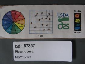 | | 2019 | | | | | | | Wild material | | 2098154 | NA 88129 |
| 24 | OPGC 7934 | NEWFS-162 | Solidago altissima L. | Massachusetts, United States | OPGC |  | | 2019 | | | | | | | Wild material | | 2098141 | OPGC 7934 |
| 25 | W6 57084 | MARSB-216 | Carex annectens (E. P. Bicknell) E. P. Bicknell | New York, United States | W6 |  | | 2019 | | | | | | | Wild material | | 2097523 | W6 57084 |
| 26 | NA 88074 | NEWFS-628 | Ilex verticillata (L.) A. Gray | Maine, United States | NA |  | | 2019 | COLLECTED | 11/16/2016 | Wells Reserve: from Boston, take 93N to 95N to ME-109S. Left on US-1N. Right on Laudholm Farm Rd. Left on Skinner Mill Rd. Park at the reserve paring lot, walk across field to trails and boardwalk through bog. (Ref: NEWFS-452) | 43.33672000, -70.55488000 | 9 | Bog, bog/woodland edge, and wet meadow. | Wild material | | 1976304 | NA 88074 |
| 27 | NA 88078 | NEWFS-689 | Morella caroliniensis (Mill.) Small | Rhode Island, United States | NA | 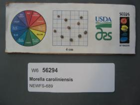 | | 2019 | | | | | | | Wild material | | 1976329 | NA 88078 |
| 28 | W6 56324 | NEWFS-841 | Rhus typhina L. | Massachusetts, United States | W6 |  | | 2019 | | | | | | | Wild material | | 1976359 | W6 56324 |
| 29 | NA 87966 | NEWFS-549 | Morella caroliniensis (Mill.) Small | Rhode Island, United States | NA |  | | 2017 | | | | | | | Wild material | | 1954728 | NA 87966 |
| 30 | NA 88341 | NEWFS-91 | Iva frutescens L. | Rhode Island, United States | NA |  | | 2017 | | | | | | | Wild material | | 1954672 | NA 88341 |
| 31 | WLP 2057 | NEWFS-270 | Viburnum dentatum L. | Maine, United States | NA |  | | 2017 | COLLECTED | 08/11/2015 | Scarborough Marsh WMA just off Pine Point Road along trail across from Audubon Center, Cumberland County | 43.56536400, -70.37482700 | 1 | Saltmarsh | Wild material | | 1954666 | WLP 2057 |
| 32 | Ames 33741 | UC 094 | Aronia melanocarpa (Michx.) Elliott | New York, United States | NC7 |  | | 2016 | COLLECTED | 11/01/2009 | Near Vestal, Broome County | 42.08065000, -75.96586700 | 315 | Edge of marsh growing in moist mossy area. Growing in association with Vaccinum angustifolium., Spirea tomentosa, Betula populifolia, and Pinus strobus | Wild material | | 1942827 | Ames 33741 |
| 33 | W6 48867 | MARSB-59 | Juncus tenuis Willd. | New York, United States | W6 |  | | 2015 | | | | | | | Wild material | | 1922918 | W6 48867 |
| 34 | Ames 32830 | BJP/C.AM/2014/002 | Cornus amomum Mill. | Maine, United States | NC7 | | | 2014 | COLLECTED | 09/04/2014 | Field edge near Levant Elementary School, Levant, Penobscot County, Maine. | 44.86062400, -69.00069200 | 71 | Wetland. Growing in association with Salix spp., Alnus incana, and Betula populifolia | Wild material | | 1921790 | Ames 32830 |