| 0 | WLP 736 | PCC16-GE58 | Betula pubescens Ehrh. var. litwinowii (Doluch.) Ashburner & McAll. | K'akheti, Georgia | NA | | | 2016 | COLLECTED | 08/24/2016 | Tusheti Natural Reserve. Western side of unnamed road, ca 550 air meters southeast of Beghela. | 42.40230000, 45.53756000 | 2042 | On steep, south-facing slope in part shade. Open subalpine Pinus/Betula woodland. Growing in shale. | | | 2116155 | WLP 736 |
| 1 | Ames 32965 | JDC/BA/2015/051/708 | Betula alleghaniensis Britton | Iowa, United States | NC7 | | | 2015 | COLLECTED | 09/15/2015 | Yellow River State Forest, T97N R4W northern edge of SW 1/4 NW 1/4 Sec. 36 | 43.17782100, -91.26584600 | 227 | North-facing algific talus slope (45-60 degrees) adjacent to Paint Creek. Moist deciduous woods. Growing in association with Fraxinus nigra, Staphylea trifolia, Carpinus caroliniana, Quercus rubra, Acer saccharum, Cornus alternifolia, Amelanchier arborea, Ostrya virginiana, Viburnum opulus var. americanum, Cornus rugosa, Cornus alternifolia, Zanthoxylum americanum, Viburnum rafinesqueanum, Cypripedium pubescens, Ribes sp.,Corylus sp., Juniperus virginiana, Dirca palustris, Ulmus thomasii, Prunella vulgaris, Diervilla lonicera, Quercus macrocarpa, Carya cordiformis, Taxus canadensis, Tilia americana, Adiantum pedatum, and Aconitum noveboracense. | Wild material | | 1927435 | Ames 32965 |
| 2 | W6 41801 | R10-57-236 | Avenula pubescens (Huds.) Dumort. | Adygeja, Russian Federation | W6 | | | 2011 | COLLECTED | 08/04/2010 | Lago-Naki Nature Reserve | 44.06300000, 40.01900000 | 1797 | Sub-alpine forest openings and rock outcrops. Limestone parent material, W slope ranging from 0-20%: seed collected from >100 plants | Wild material | | 1883320 | W6 41801 |
| 3 | NA 68772 | NACPEC97013 | Syringa pubescens Turcz. subsp. patula (Palib.) M. C. Chang & X. L. Chen | Jilin Sheng, China | NA | | | 1997 | COLLECTED | 10/01/1997 | Changbai County, above Yalu River | 41.61916667, 128.29333333 | 1000 | Ridge above river with Betula platyphylla, Acer barbinerve and Rhododendron dauricum; 45% W slope. | Wild material | 2 m; shrub; leaves turning purple; fruit green capsules | 1579164 | NA 68772 |
| 4 | NA 68854 | NACPEC97095 | Syringa pubescens Turcz. subsp. patula (Palib.) M. C. Chang & X. L. Chen | Jilin Sheng, China | NA | | | 1997 | COLLECTED | 10/01/1997 | Changbai County, along Yalu River | 41.62638889, 128.29000000 | 1000 | On rocky slopes with Betula platyphylla, Betula costata, Tilia amurensis, Acer tegmentosum, Acer pseudosiebolianum; 60% NW slope. | Wild material | 2-3 m; shrub; leaves turning deep wine color; fruit green to brown | 1579181 | NA 68854 |
| 5 | NA 67796 | QLG166 | Syringa pubescens Turcz. subsp. microphylla (Diels) M. C. Chang & X. L. Chen | Shaanxi Sheng, China | NA | | | 1996 | COLLECTED | 10/18/1996 | Ningxi Preserve, Caiziping Forest Station, Xi Gou | 33.71694444, 108.20027778 | 1985 | Shade at the base of a moist cliff with seepage; 35% N slope; sandy loam soil; growing w/ Rubus, Philadelphus, ferns, Acer, Betula, Sinacalcia tangutica, Populus, Euonymus and several herbaceous species. | Wild material | 3 meters; multi-stemmed, deciduous shrub with spreading habit | 1579579 | NA 67796 |
| 6 | NA 61637 | NA 61637 | Syringa pubescens Turcz. subsp. patula (Palib.) M. C. Chang & X. L. Chen | Korea, South | NA | | | 1989 | COLLECTED | 09/20/1989 | Odae San, Kang-won Do | 37.74444444, 128.58055556 | 680 | Growing with Ulmus davidiana, Pinus densiflora, Betula schmidtii, Quercus sp. | Wild material | | 1498263 | NA 61637 |
| 7 | PI 665623 | R08-16-078 | Agrostis gigantea Roth | Russian Federation | W6 | | | 2009 | COLLECTED | 08/14/2008 | Near Kara village, 96 km southwest of Beloretsk. District of Beloretsk. Oblast = Bashkortostan | 53.33000000, 57.43000000 | 506 | Side of road in Betula pubescens, Pinus sylvestris forest, east facing 10% slope, in vicinity of Belaya River | Wild material | | 1811717 | PI 665623 |
| 8 | PI 665624 | R08-17-084 | Dactylis glomerata L. | Russian Federation | W6 | | | 2009 | COLLECTED | 08/14/2008 | Near Uzyan village, 82 km southwest of Beloretsk. District of Beloretsk. Oblast = Bashkortostan | 53.44000000, 57.54000000 | 487 | Ditchbank along both sides of road | Wild material | | 1811723 | PI 665624 |
| 9 | PI 665629 | R08-28-125 | Bromus inermis Leyss. subsp. inermis | Russian Federation | W6 | | | 2009 | COLLECTED | 08/18/2008 | 13 km south/southwest of Krasnogorsk and 30 km ssw of Yemanzhelinsk. District of Yemanzhelinsk. Oblast = Chelyabinsk | 54.50000000, 61.18000000 | 256 | In sparse birch forest area, no slope | Wild material | | 1811760 | PI 665629 |
| 10 | PI 665630 | R08-31-137 | Bromus inermis Leyss. subsp. inermis | Russian Federation | W6 | | | 2009 | COLLECTED | 08/20/2008 | 33 km southwest of Ozersk. District of Ozerskiy. Oblast = Chelyabinsk | 55.49000000, 60.47000000 | 226 | Along roadside at margin of wet meadow hayfield, unbelievable diversity, in vicinity of Lake Irtyaga | Wild material | | 1811770 | PI 665630 |
| 11 | PI 665631 | R08-31-142 | Agrostis gigantea Roth | Russian Federation | W6 |  | | 2009 | COLLECTED | 08/20/2008 | 33 km southwest of Ozersk. District of Ozerskiy. Oblast = Chelyabinsk | 55.49000000, 60.47000000 | 226 | Along roadside at margin of wet meadow hayfield, unbelievable diversity, in vicinity of Lake Irtyaga | Wild material | | 1811774 | PI 665631 |
| 12 | PI 665632 | R08-31-144 | Dactylis glomerata L. | Russian Federation | W6 | | | 2009 | COLLECTED | 08/20/2008 | 33 km southwest of Ozersk. District of Ozerskiy. Oblast = Chelyabinsk | 55.49000000, 60.47000000 | 226 | Along roadside at margin of wet meadow hayfield, unbelievable diversity, in vicinity of Lake Irtyaga | Wild material | | 1811775 | PI 665632 |
| 13 | PI 665633 | R08-34-148 | Dactylis glomerata L. | Russian Federation | W6 | | | 2009 | COLLECTED | 08/21/2008 | Near Dalnaya Dacha village, 41 km southwest of Kyshtym. District of Kyshtymskiy. Oblast = Chelyabinsk | 55.38000000, 60.28000000 | 296 | Along power line corridor clearing, in pine-birch forest | Wild material | | 1811779 | PI 665633 |
| 14 | PI 665634 | R08-37-161 | Dactylis glomerata L. | Russian Federation | W6 | | | 2009 | COLLECTED | 08/23/2008 | 3 km south of Satki. District of Satkinskiy. Oblast = Chelyabinsk | 55.02000000, 59.00000000 | 435 | North facing, 10% slope, in hay meadow on edge of birch-pine forest, in vicinity of Satki Reservoir | Wild material | | 1811791 | PI 665634 |
| 15 | PI 665635 | R08-39-172 | Bromus inermis Leyss. subsp. inermis | Russian Federation | W6 | | | 2009 | COLLECTED | 08/24/2008 | Near Verhniye Kigi village, 31 km south of Mesyagutovo and 8 km east of Musatovo. District of Kiginskiy. Oblast = Bashkortostan | 55.26000000, 58.33000000 | 593 | Along margin of hayfield in rolling mountains | Wild material | | 1811799 | PI 665635 |
| 16 | PI 665636 | R08-39-175 | Dactylis glomerata L. | Russian Federation | W6 | | | 2009 | COLLECTED | 08/24/2008 | Near Verhniye Kigi village, 31 km south of Mesyagutovo and 8 km east of Musatovo. District of Kiginskiy. Oblast = Bashkortostan | 55.26000000, 58.33000000 | 593 | Along margin of hayfield in rolling mountains | Wild material | | 1811802 | PI 665636 |
| 17 | PI 670424 | R08-11-052 | Dactylis glomerata L. | Russian Federation | W6 | | | 2009 | COLLECTED | 08/10/2008 | Near Makarovo village, 26 km southeast of Ishimbay. District of Ishimbaevskiy. Oblast = Bashkortostan | 53.37000000, 56.40000000 | 248 | National Park, narrow canyon, at base of cliffs and talus, 40% south slope | Wild material | | 1811693 | PI 670424 |
| 18 | PI 670425 | R08-11-053 | Poa versicolor Besser subsp. stepposa (Krylov) Tzvelev | Russian Federation | W6 | | | 2009 | COLLECTED | 08/10/2008 | Near Makarovo village, 26 km southeast of Ishimbay. District of Ishimbaevskiy. Oblast = Bashkortostan | 53.37000000, 56.40000000 | 248 | National Park, narrow canyon, at base of cliffs and talus, 40% south slope | Wild material | | 1811694 | PI 670425 |
| 19 | PI 670426 | R08-13-060 | Dactylis glomerata L. | Russian Federation | W6 | | | 2009 | COLLECTED | 08/11/2008 | 13 km south of Ishimbay. District of Ishimbaevskiy. Oblast = Bashkortostan | 53.34000000, 56.04000000 | 565 | National Park, open meadow 5% west slope along road and power line corridor with adjacent areas used for hay-making | Wild material | | 1811701 | PI 670426 |
| 20 | PI 670430 | R08-15-073 | Poa pratensis L. | Russian Federation | W6 | | | 2009 | COLLECTED | 08/13/2008 | Near Akbulat village, 135 km southwest of Beloretsk. District of Beloretsk. Oblast = Bashkortostan | 53.04000000, 57.09000000 | 412 | Hay harvesting meadow in between trees, south facing 10 % slope (near 12,000 yr man cave) | Wild material | | 1811712 | PI 670430 |
| 21 | PI 670431 | R08-16-076 | Dactylis glomerata L. | Russian Federation | W6 | | | 2009 | COLLECTED | 08/14/2008 | Near Kara village, 96 km southwest of Beloretsk. District of Beloretsk. Oblast = Bashkortostan | 53.33000000, 57.43000000 | 506 | Side of road in Betula pubescens, Pinus sylvestris forest, east facing 10% slope, in vicinity of Belaya River | Wild material | | 1811715 | PI 670431 |
| 22 | PI 670432 | R08-16-079 | Poa pratensis L. | Russian Federation | W6 | | | 2009 | COLLECTED | 08/14/2008 | Near Kara village, 96 km southwest of Beloretsk. District of Beloretsk. Oblast = Bashkortostan | 53.33000000, 57.43000000 | 506 | Side of road in Betula pubescens, Pinus sylvestris forest, east facing 10% slope, in vicinity of Belaya River | Wild material | | 1811718 | PI 670432 |
| 23 | PI 670433 | R08-17-086 | Phleum pratense L. | Russian Federation | W6 | | | 2009 | COLLECTED | 08/14/2008 | Near Uzyan village, 82 km southwest of Beloretsk. District of Beloretsk. Oblast = Bashkortostan | 53.44000000, 57.54000000 | 487 | Ditchbank along both sides of road | Wild material | | 1811725 | PI 670433 |
| 24 | PI 670436 | R08-42-192 | Festuca rubra L. | Russian Federation | W6 | | | 2009 | COLLECTED | 08/25/2008 | Near Bartym village, 46 km southeast of Karaidel. District of Karaidelskiy. Oblast = Bashkortostan | 55.48000000, 57.33000000 | 351 | Along drainage area in hayfield meadow in birch-pine forest, in vicinity of Bolshaya Berdyashka River | Wild material | | 1811818 | PI 670436 |
| 25 | PI 675193 | R08-32-145 | Phleum phleoides (L.) H. Karst. | Russian Federation | W6 | | | 2009 | COLLECTED | 08/21/2008 | Near Vishevogorsk town, 18 km southwest of Kyshtym. District of Kaslinskiy. Oblast = Chelyabinsk | 55.58000000, 60.39000000 | 249 | An exposed dry, gravelly ridge in a pine-birch forest, in vicinity of Lake Sungul | Wild material | | 1811776 | PI 675193 |
| 26 | PI 675194 | R08-32-146 | Agropyron cristatum (L.) Gaertn. subsp. pectinatum (M. Bieb.) Tzvelev var. pectinatum (M. Bieb.) Tzvelev | Russian Federation | W6 |  | | 2009 | COLLECTED | 08/21/2008 | Near Vishevogorsk town, 18 km southwest of Kyshtym. District of Kaslinskiy. Oblast = Chelyabinsk | 55.58000000, 60.39000000 | 249 | An exposed dry, gravelly ridge in a pine-birch forest, in vicinity of Lake Sungul | Wild material | | 1811777 | PI 675194 |
| 27 | PI 675263 | R08-10-051 | Festuca pratensis Huds. | Russian Federation | W6 | | | 2009 | COLLECTED | 08/10/2008 | Near Makarovo village, 25 km southeast of Ishimbay. District of Ishimbaevskiy. Oblast = Bashkortostan | 53.36000000, 56.37000000 | 203 | Mountain meadow along Sikasya River, cows grazing | Wild material | | 1811692 | PI 675263 |
| 28 | PI 675264 | R08-15-070 | Festuca pratensis Huds. | Russian Federation | W6 | | | 2009 | COLLECTED | 08/13/2008 | Near Akbulat village, 135 km southwest of Beloretsk. District of Beloretsk. Oblast = Bashkortostan | 53.04000000, 57.09000000 | 412 | Hay harvesting meadow in between trees, south facing 10 % slope (near 12,000 yr man cave) | Wild material | | 1811711 | PI 675264 |
| 29 | PI 675265 | R08-16-077 | Festuca pratensis Huds. | Russian Federation | W6 |  | | 2009 | COLLECTED | 08/14/2008 | Near Kara village, 96 km southwest of Beloretsk. District of Beloretsk. Oblast = Bashkortostan | 53.33000000, 57.43000000 | 506 | Side of road in Betula pubescens, Pinus sylvestris forest, east facing 10% slope, in vicinity of Belaya River | Wild material | | 1811716 | PI 675265 |
| 30 | PI 675266 | R08-17-082 | Festuca pratensis Huds. | Russian Federation | W6 |  | | 2009 | COLLECTED | 08/14/2008 | Near Uzyan village, 82 km southwest of Beloretsk. District of Beloretsk. Oblast = Bashkortostan | 53.44000000, 57.54000000 | 487 | Ditchbank along both sides of road | Wild material | | 1811721 | PI 675266 |
| 31 | PI 675270 | R08-26-117 | Poa pratensis L. | Russian Federation | W6 | | | 2009 | COLLECTED | 08/18/2008 | Near Roschino village, 25 km south of Yuzhnoural'sk. District of South Ural. Oblast = Chelyabinsk | 54.22000000, 61.19000000 | 236 | Hayfield in dry valley meadow with birch scrub | Wild material | | 1811753 | PI 675270 |
| 32 | PI 675271 | R08-27-123 | Agropyron cristatum (L.) Gaertn. subsp. pectinatum (M. Bieb.) Tzvelev var. pectinatum (M. Bieb.) Tzvelev | Russian Federation | W6 |  | | 2009 | COLLECTED | 08/18/2008 | 8 km southwest of Yuzhnoural'sk and 24 km south of Krasnogorsk. District of Krasnogorsk. Oblast = Chelyabinsk | 54.40000000, 61.15000000 | 254 | Along roadside and rest area of old road | Wild material | | 1811758 | PI 675271 |
| 33 | PI 675272 | R08-31-135 | Poa pratensis L. | Russian Federation | W6 | | | 2009 | COLLECTED | 08/20/2008 | 33 km southwest of Ozersk. District of Ozerskiy. Oblast = Chelyabinsk | 55.49000000, 60.47000000 | 226 | Along roadside at margin of wet meadow hayfield, unbelievable diversity, in vicinity of Lake Irtyaga | Wild material | | 1811768 | PI 675272 |
| 34 | PI 675273 | R08-34-149 | Poa pratensis L. | Russian Federation | W6 | | | 2009 | COLLECTED | 08/21/2008 | Near Dalnaya Dacha village, 41 km southwest of Kyshtym. District of Kyshtymskiy. Oblast = Chelyabinsk | 55.38000000, 60.28000000 | 296 | Along power line corridor clearing, in pine-birch forest | Wild material | | 1811780 | PI 675273 |
| 35 | PI 675274 | R08-37-162 | Poa pratensis L. | Russian Federation | W6 | | | 2009 | COLLECTED | 08/23/2008 | 3 km south of Satki. District of Satkinskiy. Oblast = Chelyabinsk | 55.02000000, 59.00000000 | 435 | North facing, 10% slope, in hay meadow on edge of birch-pine forest, in vicinity of Satki Reservoir | Wild material | | 1811792 | PI 675274 |
| 36 | PI 675275 | R08-38-165 | Phleum pratense L. | Russian Federation | W6 | | | 2009 | COLLECTED | 08/23/2008 | Near Suleya village, 28 km west of Satki. District of Satkinskiy. Oblast = Chelyabinsk | 55.05000000, 58.53000000 | 596 | East facing 5% slope, in power line corridor through pine-birch forest, in vicinity of Satki River | Wild material | | 1811795 | PI 675275 |
| 37 | PI 675276 | R08-38-169 | Elymus fibrosus (Schrenk) Tzvelev | Russian Federation | W6 | | | 2009 | COLLECTED | 08/23/2008 | Near Suleya village, 28 km west of Satki. District of Satkinskiy. Oblast = Chelyabinsk | 55.05000000, 58.53000000 | 596 | East facing 5% slope, in power line corridor through pine-birch forest, in vicinity of Satki River | Wild material | | 1811796 | PI 675276 |
| 38 | PI 675327 | R08-36-157 | Phleum pratense L. | Russian Federation | W6 | | | 2009 | COLLECTED | 08/22/2008 | Near Novoandreevka village, 30 km south of Karabash. District of Karabashskiy. Oblast = Chelyabinsk | 55.19000000, 60.13000000 | 394 | Hay cutting area in middle of pine/birch forest, in vicinity of Ilmen Natural Reserve | Wild material | | 1811787 | PI 675327 |
| 39 | PI 676179 | R08-29-128 | Festuca pratensis Huds. | Russian Federation | W6 | | | 2009 | COLLECTED | 08/19/2008 | Near Klyuchevka village, 15 km west of Chelyabinsk. District of Sosnovskiy. Oblast = Chelyabinsk | 55.21000000, 61.18000000 | 212 | Along edge of sparse birch forest, no slope, in vicinity of Zyuzelga River | Wild material | | 1811762 | PI 676179 |
| 40 | PI 676180 | R08-34-151 | Festuca pratensis Huds. | Russian Federation | W6 | | | 2009 | COLLECTED | 08/21/2008 | Near Dalnaya Dacha village, 41 km southwest of Kyshtym. District of Kyshtymskiy. Oblast = Chelyabinsk | 55.38000000, 60.28000000 | 296 | Along power line corridor clearing, in pine-birch forest | Wild material | | 1811782 | PI 676180 |
| 41 | PI 676238 | R08-13-058 | Festuca pratensis Huds. | Russian Federation | W6 | | | 2009 | COLLECTED | 08/11/2008 | 13 km south of Ishimbay. District of Ishimbaevskiy. Oblast = Bashkortostan | 53.34000000, 56.04000000 | 565 | National Park, open meadow 5% west slope along road and power line corridor with adjacent areas used for hay-making | Wild material | | 1811699 | PI 676238 |
| 42 | PI 676239 | R08-35-155 | Poa pratensis L. subsp. angustifolia (L.) Arcang. | Russian Federation | W6 |  | | 2009 | COLLECTED | 08/21/2008 | 24 km south of Karabash. District of Karabashskiy. Oblast = Chelyabinsk | 55.24000000, 60.16000000 | 285 | Meadow area below a birch forest | Wild material | | 1811786 | PI 676239 |
| 43 | PI 676244 | R08-13-057 | Agrostis gigantea Roth | Russian Federation | W6 | | | 2009 | COLLECTED | 08/11/2008 | 13 km south of Ishimbay. District of Ishimbaevskiy. Oblast = Bashkortostan | 53.34000000, 56.04000000 | 565 | National Park, open meadow 5% west slope along road and power line corridor with adjacent areas used for hay-making | Wild material | | 1811698 | PI 676244 |
| 44 | PI 678897 | R08-17-087 | Trifolium hybridum L. | Russian Federation | W6 | | | 2009 | COLLECTED | 08/14/2008 | Near Uzyan village, 82 km southwest of Beloretsk. District of Beloretsk. Oblast = Bashkortostan | 53.44000000, 57.54000000 | 487 | Ditchbank along both sides of road | Wild material | | 1811726 | PI 678897 |
| 45 | PI 685584 | R08-34-150 | Agrostis gigantea Roth | Russian Federation | W6 | | | 2009 | COLLECTED | 08/21/2008 | Near Dalnaya Dacha village, 41 km southwest of Kyshtym. District of Kyshtymskiy. Oblast = Chelyabinsk | 55.38000000, 60.28000000 | 296 | Along power line corridor clearing, in pine-birch forest | Wild material | | 1811781 | PI 685584 |
| 46 | PI 685585 | R08-41-188 | Agrostis gigantea Roth | Russian Federation | W6 | | | 2009 | COLLECTED | 08/25/2008 | Near Batkul village, 40 km southwest of Duvan. District of Duvanskiy. Oblast = Bashkortostan | 55.46000000, 57.42000000 | 414 | In meadow area surrounded by birch-spruce forest, with west facing 5% slope | Wild material | | 1811814 | PI 685585 |
| 47 | PI 689103 | R08-13-059 | Poa pratensis L. | Russian Federation | W6 | | | 2009 | COLLECTED | 08/11/2008 | 13 km south of Ishimbay. District of Ishimbaevskiy. Oblast = Bashkortostan | 53.34000000, 56.04000000 | 565 | National Park, open meadow 5% west slope along road and power line corridor with adjacent areas used for hay-making | Wild material | | 1811700 | PI 689103 |
| 48 | PI 693217 | R08-34-150 | Agrostis gigantea Roth | Russian Federation | W6 | | | 2009 | COLLECTED | 08/21/2008 | Near Dalnaya Dacha village, 41 km southwest of Kyshtym. District of Kyshtymskiy. Oblast = Chelyabinsk | 55.38000000, 60.28000000 | 296 | Along power line corridor clearing, in pine-birch forest | Wild material | | 1953778 | PI 693217 |
| 49 | PI 693815 | R08-10-050 | Agrostis gigantea Roth | Russian Federation | W6 | | | 2009 | COLLECTED | 08/10/2008 | Near Makarovo village, 25 km southeast of Ishimbay. District of Ishimbaevskiy. Oblast = Bashkortostan | 53.36000000, 56.37000000 | 203 | Mountain meadow along Sikasya River, cows grazing | Wild material | | 1811691 | PI 693815 |
| 50 | PI 693817 | R08-17-085 | Poa pratensis L. | Russian Federation | W6 |  | | 2009 | COLLECTED | 08/14/2008 | Near Uzyan village, 82 km southwest of Beloretsk. District of Beloretsk. Oblast = Bashkortostan | 53.44000000, 57.54000000 | 487 | Ditchbank along both sides of road | Wild material | | 1811724 | PI 693817 |
| 51 | PI 698674 | R08-37-159 | Poa nemoralis L. | Russian Federation | W6 | | | 2009 | COLLECTED | 08/23/2008 | 3 km south of Satki. District of Satkinskiy. Oblast = Chelyabinsk | 55.02000000, 59.00000000 | 435 | North facing, 10% slope, in hay meadow on edge of birch-pine forest, in vicinity of Satki Reservoir | Wild material | | 1811789 | PI 698674 |
| 52 | PI 710709 | R08-33-147 | Melilotus albus Medik. | Chelyabinsk, Russian Federation | NC7 |  | | 2009 | COLLECTED | 08/21/2008 | 38 km southwest of Kyshtym, District of Kyshtymskiy. | 55.41000000, 60.30000000 | 274 | On edge of pine-birch forest. Associated with Achillea millefolium, Agrostis gigantea, Betula pubescens, Bromus inermis, Calamagrostis, Festuca pratensis, Melilotus albus, Pinus sylvestris, and Trifolium pratense. | Wild material | | 1811778 | PI 710709 |
| 53 | PI 710713 | R08-26-118 | Melilotus officinalis (L.) Lam. | Chelyabinsk, Russian Federation | NC7 |  | | 2009 | COLLECTED | 08/18/2008 | Near Roschino village, 25 km south of Yuzhnoural'sk, District of South Ural. | 54.22000000, 61.19000000 | 236 | Hayfield in dry valley meadow with birch scrub. Associated with Achillea millefolium, Agrostis gigantea, Betula pubescens, Bromus inermis, Calamagrostis, Festuca rubra, Melilotus officinalis, Plantago, Poa pratensis, and Trifolium pratense. | Wild material | | 1811754 | PI 710713 |
| 54 | PI 710714 | R08-30-130 | Melilotus albus Medik. | Chelyabinsk, Russian Federation | NC7 |  | | 2009 | COLLECTED | 08/20/2008 | Near Bolshoy Kuyash village, 41 km southwest of Kunashak. District of Kunashakskiy. Oblast = Chelyabinsk | 55.49000000, 61.03000000 | 255 | Along ditchbank on edge of birch forest. Associated with Achillea millefolium, Betula pubescens, Bromus inermis, Cirsium, Medicago falcata, Plantago, and Rumex crispus. | Wild material | | 1811764 | PI 710714 |
| 55 | PI 710715 | R08-39-171 | Melilotus officinalis (L.) Lam. | Baškortostan, Respublika, Russian Federation | NC7 |  | | 2009 | COLLECTED | 08/24/2008 | Near Verhniye Kigi village, 31 km south of Mesyagutovo and 8 km east of Musatovo, District of Kiginskiy. | 55.26000000, 58.33000000 | 593 | Along margin of hayfield in rolling mountains. Associated with Achillea millefolium, Betula pubescens, Bromus inermis, Dactylis glomerata, Melilotus officinalis, Poa pratensis, and Trifolium pratense. | Wild material | | 1811798 | PI 710715 |
| 56 | PI 710717 | R08-43-194 | Melilotus officinalis (L.) Lam. | Baškortostan, Respublika, Russian Federation | NC7 |  | | 2009 | COLLECTED | 08/25/2008 | Near village Bayki, 47 km southwest of Karaidel, District of Karaidelskiy. | 55.49000000, 56.49000000 | 256 | In birch-pine shelter-belt along highway. Associated with Betula pubescens, Melilotus albus, M. officinalis, Pinus sylvestris, Poa pratensis, Taraxacum, and Trifolium pratense. | Wild material | | 1811819 | PI 710717 |
| 57 | PI 710719 | R08-31-143 | Melilotus albus Medik. | Chelyabinsk, Russian Federation | NC7 |  | | 2009 | COLLECTED | 08/20/2008 | Vicinity of Lake Irtyaga, 33 km southwest of Ozersk, District of Ozerskiy. | 55.49000000, 60.47000000 | 226 | Along roadside at margin of wet meadow hayfield. Assoc. w/ Betula pubescens, Bromus inermis, Dactylis glomerata, Festuca pratensis, F. rubra, Medicago falcata, Pinus sylvestris, Poa pratensis, Sanguisorba, Trifolium montanum, & T. pratense. | Wild material | | 1811832 | PI 710719 |
| 58 | PI 710696 | R07-17-063 | Melilotus albus Medik. | Novgorod, Russian Federation | NC7 |  | | 2008 | COLLECTED | 08/15/2007 | Dubrovo Village, Pestova District. | 58.49944444, 35.27138889 | 174 | West facing road bank, dry sandy meadow with moss on surface. Associated with Betula pubescens, Festuca pratensis, Melilotus albus, Pinus sylvestris, Poa pratensis, and Poa sp. | Wild material | | 1779768 | PI 710696 |
| 59 | PI 710697 | R07-19-072 | Melilotus albus Medik. | Vologda, Russian Federation | NC7 |  | | 2008 | COLLECTED | 08/15/2007 | Zalesye Village, Ustyuzhna District. | 58.69638889, 36.16833333 | 140 | Abandoned cropland surrounded by Betula/Pinus forest. Associated with Betula pubescens, Centaurea, Dactylis glomerata, Elytrigia repens, Festuca pratensis, Pinus sylvestris, Trifolium medium, and Vicia. | Wild material | | 1779769 | PI 710697 |
| 60 | PI 710700 | R07-28-112 | Melilotus albus Medik. | Yaroslavl, Russian Federation | NC7 |  | | 2008 | COLLECTED | 08/18/2007 | Shahovka Village, Poshehonsky District. | 58.50916667, 38.97527778 | 115 | Regrowth under power line; pine/birch/Alnus forest. Associated with Alnus, Betula pubescens, Calamagrostis epigejos, Carex, Deschampsia cespitosa, Festuca pratensis, F. rubra, Phleum pratense, Pinus sylvestris, Poa pratensis, & Trifolium. | Wild material | | 1779772 | PI 710700 |
| 61 | PI 710701 | R07-30-120 | Melilotus albus Medik. | Yaroslavl, Russian Federation | NC7 |  | | 2008 | COLLECTED | 08/19/2007 | Dymovskoye Village, Rybinsk District. | 58.19666667, 38.85833333 | 119 | Along edge of hay field surrounded by Betula/Alnus forest. Associated with Alnus, Betula pubescens, Cirsium, Dactylis glomerata, Deschampsia cespitosa, Festuca pratensis, Lathyrus pratensis, Melilotus albus, and Poa pratensis. | Wild material | | 1779773 | PI 710701 |
| 62 | PI 710702 | R07-33-135 | Melilotus albus Medik. | Ivanovo, Russian Federation | NC7 |  | | 2008 | COLLECTED | 08/23/2007 | Chirokovo Village, Formanov District. | 57.18333333, 41.09500000 | 146 | Understory of birch/pine forest and abandoned cropland along edge of forest. Associated with Agrostis gigantea, Betula pubescens, Cirsium, Dactylis glomerata, Pinus sylvestris, Poa pratensis, Trifolium hybridum, and Trifolium medium. | Wild material | | 1779774 | PI 710702 |
| 63 | PI 710704 | R07-42-160 | Melilotus albus Medik. | Tver, Russian Federation | NC7 |  | | 2008 | COLLECTED | 08/30/2007 | Susoliha Village, Kashin District. | 57.26611111, 37.23972222 | 116 | Clearing under power line surrounded by birch/pine forest. Associated with Agrostis gigantea, Betula pubescens, Calamagrostis epigejos, Carex, Epilobium, Festuca pratensis, Juncus, Phleum pratense, Picea abies, and Pinus sylvestris. | Wild material | | 1779776 | PI 710704 |
| 64 | PI 662365 | R07-12-037 | Phleum pratense L. | Novgorod, Russian Federation | W6 | | | 2008 | COLLECTED | 08/12/2007 | Ostriokletki Village. Borovichsky district | 58.03944444, 33.57027778 | 191 | Along roadside and into abandoned field | Wild material | | 1778074 | PI 662365 |
| 65 | PI 662366 | R07-17-061 | Dactylis glomerata L. | Novgorod, Russian Federation | W6 | | | 2008 | COLLECTED | 08/15/2007 | Dubrovo Village. Pestova district | 58.49944444, 35.27138889 | 174 | West facing road bank, dry sandy meadow with moss on surface | Wild material | | 1778096 | PI 662366 |
| 66 | PI 662369 | R07-19-073 | Festuca rubra L. | Vologda, Russian Federation | W6 | | | 2008 | COLLECTED | 08/15/2007 | Zalesye Village. Ustyuzhna district | 58.69638889, 36.16833333 | 140 | Abandoned cropland surrounded by Betula/Pinus forest | Wild material | | 1778103 | PI 662369 |
| 67 | PI 662373 | R07-27-104 | Phleum pratense L. | Yaroslavl, Russian Federation | W6 | | | 2008 | COLLECTED | 08/18/2007 | Malofeevo Village. Poshehonsky district | 58.67666667, 38.54638889 | 111 | Abandoned field surrounded by pine/birch forest | Wild material | | 1778128 | PI 662373 |
| 68 | PI 662374 | R07-29-113 | Dactylis glomerata L. | Yaroslavl, Russian Federation | W6 | | | 2008 | COLLECTED | 08/19/2007 | Lapushka Village. Poshehonsky district | 58.35861111, 39.04027778 | 115 | Along edges of mowed hayfield, surrounded by Pinus/Betula forest | Wild material | | 1778135 | PI 662374 |
| 69 | PI 662375 | R07-33-136 | Phleum phleoides (L.) H. Karst. | Ivanovo, Russian Federation | W6 | | | 2008 | COLLECTED | 08/23/2007 | Chirokovo Village. Formanov district | 57.18333333, 41.09500000 | 146 | Understory under birch/pine forest and abandoned cropland along edge of forest | Wild material | | 1778152 | PI 662375 |
| 70 | PI 662376 | R07-34-137 | Dactylis glomerata L. | Ivanovo, Russian Federation | W6 | | | 2008 | COLLECTED | 08/23/2007 | Gruziniha Village. Lezhnevsky district | 56.74944444, 40.74583333 | 119 | Abandoned cropland along edge of birch/pine forest | Wild material | | 1778153 | PI 662376 |
| 71 | PI 662377 | R07-34-138 | Phleum pratense L. | Ivanovo, Russian Federation | W6 | | | 2008 | COLLECTED | 08/23/2007 | Gruziniha Village. Lezhnevsky district | 56.74944444, 40.74583333 | 119 | Abandoned cropland along edge of birch/pine forest | Wild material | | 1778154 | PI 662377 |
| 72 | PI 662380 | R07-42-162 | Phleum pratense L. | Tver, Russian Federation | W6 | | | 2008 | COLLECTED | 08/30/2007 | Susoliha Village. Kashin district | 57.26611111, 37.23972222 | 116 | Clearing under power line surrounded by birch/pine forest | Wild material | | 1778174 | PI 662380 |
| 73 | PI 665605 | R07-15-052 | Dactylis glomerata L. | Novgorod, Russian Federation | W6 | | | 2008 | COLLECTED | 08/13/2007 | Podferez'ye Village. Moschenskoy district | 58.42638889, 34.52444444 | 156 | Abandoned cropland along edge of Betula/Pinus forest | Wild material | | 1778088 | PI 665605 |
| 74 | PI 665608 | R07-29-116 | Agrostis gigantea Roth | Yaroslavl, Russian Federation | W6 | | | 2008 | COLLECTED | 08/19/2007 | Lapushka Village. Poshehonsky district | 58.35861111, 39.04027778 | 115 | Along edges of mowed hayfield, surrounded by Pinus/Betula forest | Wild material | | 1778138 | PI 665608 |
| 75 | PI 665609 | R07-30-121 | Dactylis glomerata L. | Yaroslavl, Russian Federation | W6 | | | 2008 | COLLECTED | 08/19/2007 | Dymovskoye Village. Rybinsk district | 58.19666667, 38.85833333 | 119 | Along edge of hayfield surrounded by Betula/Alnus forest | Wild material | | 1778142 | PI 665609 |
| 76 | PI 665611 | R07-32-131 | Agrostis gigantea Roth | Ivanovo, Russian Federation | W6 | | | 2008 | COLLECTED | 08/23/2007 | Privolzhsk Town. Privolzhsk district | 57.37888889, 41.26000000 | 99 | Understory meadow growing under birch forest on edge of village | Wild material | | 1778149 | PI 665611 |
| 77 | PI 665612 | R07-33-134 | Dactylis glomerata L. | Ivanovo, Russian Federation | W6 | | | 2008 | COLLECTED | 08/23/2007 | Chirokovo Village. Formanov district | 57.18333333, 41.09500000 | 146 | Understory under birch/pine forest and abandoned cropland along edge of forest | Wild material | | 1778151 | PI 665612 |
| 78 | PI 665613 | R07-34-139 | Festuca rubra L. | Ivanovo, Russian Federation | W6 | | | 2008 | COLLECTED | 08/23/2007 | Gruziniha Village. Lezhnevsky district | 56.74944444, 40.74583333 | 119 | Abandoned cropland along edge of birch/pine forest | Wild material | | 1778155 | PI 665613 |
| 79 | PI 665618 | R07-40-158 | Agrostis gigantea Roth | Tver, Russian Federation | W6 |  | | 2008 | COLLECTED | 08/30/2007 | Kur'yanovo Village. Kashin district | 57.25888889, 37.69527778 | 133 | Abandoned cropland area on edge of birch/pine forest | Wild material | | 1778172 | PI 665618 |
| 80 | PI 668007 | R07-07-022 | Trifolium pratense L. | Novgorod, Russian Federation | W6 |  | | 2008 | COLLECTED | 08/11/2007 | 12 km NE of Demynsk Town. Demynsk district | 57.72277778, 32.57777778 | 96 | Cleared area along edge of pine/birch forest; sandy gravel pit | Wild material | | 1778063 | PI 668007 |
| 81 | PI 668008 | R07-11-033 | Trifolium pratense L. | Novgorod, Russian Federation | W6 |  | | 2008 | COLLECTED | 08/12/2007 | Edno Village. Valday district | 58.01527778, 33.48777778 | 200 | Hayfield meadow; abandoned cropland, surrounded by Pinus/Betula forest | Wild material | | 1778070 | PI 668008 |
| 82 | PI 668009 | R07-12-040 | Trifolium pratense L. | Novgorod, Russian Federation | W6 |  | | 2008 | COLLECTED | 08/12/2007 | Ostriokletki Village. Borovichsky district | 58.03944444, 33.57027778 | 191 | Along roadside and into abandoned field | Wild material | | 1778077 | PI 668009 |
| 83 | PI 668010 | R07-14-049 | Trifolium pratense L. | Novgorod, Russian Federation | W6 |  | | 2008 | COLLECTED | 08/13/2007 | 2 km E of Kotova Village. Borovichsky district | 58.40166667, 34.25805556 | 157 | Along a cleared area on side of gravel road by edge of pine/birch forest | Wild material | | 1778085 | PI 668010 |
| 84 | PI 668011 | R07-14-050 | Trifolium medium L. | Novgorod, Russian Federation | W6 |  | | 2008 | COLLECTED | 08/13/2007 | 2 km E of Kotova Village. Borovichsky district | 58.40166667, 34.25805556 | 157 | Along a cleared area on side of gravel road by edge of pine/birch forest | Wild material | | 1778086 | PI 668011 |
| 85 | PI 668012 | R07-17-062 | Trifolium pratense L. | Novgorod, Russian Federation | W6 | | | 2008 | COLLECTED | 08/15/2007 | Dubrovo Village. Pestova district | 58.49944444, 35.27138889 | 174 | West facing road bank, dry sandy meadow with moss on surface | Wild material | | 1778097 | PI 668012 |
| 86 | PI 668013 | R07-27-105 | Trifolium pratense L. | Yaroslavl, Russian Federation | W6 | | | 2008 | COLLECTED | 08/18/2007 | Malofeevo Village. Poshehonsky district | 58.67666667, 38.54638889 | 111 | Abandoned field surrounded by pine/birch forest | Wild material | | 1778129 | PI 668013 |
| 87 | PI 668014 | R07-33-132 | Trifolium hybridum L. | Ivanovo, Russian Federation | W6 |  | | 2008 | COLLECTED | 08/23/2007 | Chirokovo Village. Formanov district | 57.18333333, 41.09500000 | 146 | Understory under birch/pine forest and abandoned cropland along edge of forest | Wild material | | 1778150 | PI 668014 |
| 88 | PI 670388 | R07-07-021 | Dactylis glomerata L. | Novgorod, Russian Federation | W6 | | | 2008 | COLLECTED | 08/11/2007 | 12 km NE of Demynsk Town. Demynsk district | 57.72277778, 32.57777778 | 96 | Cleared area along edge of pine/birch forest; sandy gravel pit | Wild material | | 1778062 | PI 670388 |
| 89 | PI 670389 | R07-09-029 | Phleum pratense L. | Novgorod, Russian Federation | W6 |  | | 2008 | COLLECTED | 08/11/2007 | Yazvicy Village. Valdaysky district | 57.89555556, 32.68472222 | 142 | Abandoned field site on margin of Pinus/Betula forest | Wild material | | 1778066 | PI 670389 |
| 90 | PI 670390 | R07-09-031 | Dactylis glomerata L. | Novgorod, Russian Federation | W6 | | | 2008 | COLLECTED | 08/11/2007 | Yazvicy Village. Valdaysky district | 57.89555556, 32.68472222 | 142 | Abandoned field site on margin of Pinus/Betula forest | Wild material | | 1778068 | PI 670390 |
| 91 | PI 670391 | R07-11-034 | Festuca arundinacea Schreb. | Novgorod, Russian Federation | W6 |  | | 2008 | COLLECTED | 08/12/2007 | Edno Village. Valday district | 58.01527778, 33.48777778 | 200 | Hayfield meadow; abandoned cropland, surrounded by Pinus/Betula forest | Wild material | | 1778071 | PI 670391 |
| 92 | PI 670392 | R07-11-035 | Dactylis glomerata L. | Novgorod, Russian Federation | W6 | | | 2008 | COLLECTED | 08/12/2007 | Edno Village. Valday district | 58.01527778, 33.48777778 | 200 | Hayfield meadow; abandoned cropland, surrounded by Pinus/Betula forest | Wild material | | 1778072 | PI 670392 |
| 93 | PI 670396 | R07-15-051 | Phleum pratense L. | Novgorod, Russian Federation | W6 |  | | 2008 | COLLECTED | 08/13/2007 | Podferez'ye Village. Moschenskoy district | 58.42638889, 34.52444444 | 156 | Abandoned cropland along edge of Betula/Pinus forest | Wild material | | 1778087 | PI 670396 |
| 94 | PI 670398 | R07-17-060 | Festuca pratensis Huds. | Novgorod, Russian Federation | W6 | | | 2008 | COLLECTED | 08/15/2007 | Dubrovo Village. Pestova district | 58.49944444, 35.27138889 | 174 | West facing road bank, dry sandy meadow with moss on surface | Wild material | | 1778095 | PI 670398 |
| 95 | PI 670399 | R07-23-087 | Bromus inermis Leyss. subsp. inermis | Vologda, Russian Federation | W6 | | | 2008 | COLLECTED | 08/16/2007 | Loent'yevo Village. Ustyuzhna district | 58.96833333, 36.59083333 | 112 | On banks of river with Pine/Birch forest above the grassy banks | Wild material | | 1778114 | PI 670399 |
| 96 | PI 670400 | R07-24-091 | Phleum pratense L. | Vologda, Russian Federation | W6 | | | 2008 | COLLECTED | 08/17/2007 | Chaevo Village. Cherepovets district | 58.91916667, 37.22277778 | 111 | Regrowth vegetation under high-voltage power line | Wild material | | 1778116 | PI 670400 |
| 97 | PI 670405 | R07-28-108 | Festuca rubra L. | Yaroslavl, Russian Federation | W6 | | | 2008 | COLLECTED | 08/18/2007 | Shahovka Village. Poshehonsky district | 58.50916667, 38.97527778 | 115 | Regrowth vegetation under high-voltage power line with pine/birch/Alnus forest | Wild material | | 1778131 | PI 670405 |
| 98 | PI 670406 | R07-29-115 | Phleum pratense L. | Yaroslavl, Russian Federation | W6 | | | 2008 | COLLECTED | 08/19/2007 | Lapushka Village. Poshehonsky district | 58.35861111, 39.04027778 | 115 | Along edges of mowed hayfield, surrounded by Pinus/Betula forest | Wild material | | 1778137 | PI 670406 |
| 99 | PI 670407 | R07-30-122 | Phleum pratense L. | Yaroslavl, Russian Federation | W6 | | | 2008 | COLLECTED | 08/19/2007 | Dymovskoye Village. Rybinsk district | 58.19666667, 38.85833333 | 119 | Along edge of hayfield surrounded by Betula/Alnus forest | Wild material | | 1778143 | PI 670407 |
| 100 | PI 675248 | R07-43-165 | Phleum pratense L. | Tver, Russian Federation | W6 | | | 2008 | COLLECTED | 08/31/2007 | Kolybeevo Village. Kimry district | 57.27916667, 37.01611111 | 132 | Abandoned cropland surrounded by birch/pine forest | Wild material | | 1778175 | PI 675248 |
| 101 | PI 678930 | R07-21-077 | Lupinus polyphyllus Lindl. | Vologda, Russian Federation | W6 | | | 2008 | COLLECTED | 08/16/2007 | Ustyuzhna City. Ustyuzhna district | 58.87750000, 36.50750000 | 121 | Along roadside with heavy Pinus/Betula forest | Wild material | | 1778105 | PI 678930 |
| 102 | PI 693792 | R07-23-086 | Poa pratensis L. | Vologda, Russian Federation | W6 |  | | 2008 | COLLECTED | 08/16/2007 | Loent'yevo Village. Ustyuzhna district | 58.96833333, 36.59083333 | 112 | On banks of river with Pine/Birch forest above the grassy banks | Wild material | | 1778113 | PI 693792 |
| 103 | PI 693795 | R07-28-109 | Poa pratensis L. | Yaroslavl, Russian Federation | W6 |  | | 2008 | COLLECTED | 08/18/2007 | Shahovka Village. Poshehonsky district | 58.50916667, 38.97527778 | 115 | Regrowth vegetation under high-voltage power line with pine/birch/Alnus forest | Wild material | | 1778132 | PI 693795 |
| 104 | PI 693796 | R07-30-119 | Poa pratensis L. | Yaroslavl, Russian Federation | W6 |  | | 2008 | COLLECTED | 08/19/2007 | Dymovskoye Village. Rybinsk district | 58.19666667, 38.85833333 | 119 | Along edge of hayfield surrounded by Betula/Alnus forest | Wild material | | 1778141 | PI 693796 |
| 105 | PI 693797 | R07-32-130 | Poa pratensis L. | Ivanovo, Russian Federation | W6 |  | | 2008 | COLLECTED | 08/23/2007 | Privolzhsk Town. Privolzhsk district | 57.37888889, 41.26000000 | 99 | Understory meadow growing under birch forest on edge of village | Wild material | | 1778148 | PI 693797 |
| 106 | PI 699258 | R07-24-089 | Agrostis gigantea Roth | Vologda, Russian Federation | W6 |  | | 2008 | COLLECTED | 08/17/2007 | Chaevo Village. Cherepovets district | 58.91916667, 37.22277778 | 111 | Regrowth vegetation under high-voltage power line | Wild material | | 1778115 | PI 699258 |
| 107 | PI 699259 | R07-27-103 | Agrostis gigantea Roth | Yaroslavl, Russian Federation | W6 |  | | 2008 | COLLECTED | 08/18/2007 | Malofeevo Village. Poshehonsky district | 58.67666667, 38.54638889 | 111 | Abandoned field surrounded by pine/birch forest | Wild material | | 1778127 | PI 699259 |
| 108 | PI 699260 | R07-43-166 | Agrostis gigantea Roth | Tver, Russian Federation | W6 |  | | 2008 | COLLECTED | 08/31/2007 | Kolybeevo Village. Kimry district | 57.27916667, 37.01611111 | 132 | Abandoned cropland surrounded by birch/pine forest | Wild material | | 1778176 | PI 699260 |
| 109 | NA 89081 | 2024RJLPA-009 | Rosa carolina L. | Pennsylvania, United States | NA | | | 2024 | COLLECTED | 09/22/2024 | Lancaster and York Counties: outcrops along the Susquehanna River, accessed from the Historic Lock 12 parking lot off of Pennsylvania Road 372. | 39.81483500, -76.32762200 | 34 | Plants are growing from part-sun to full sun in crevices of the outcrops and where organic debris has accumulated in between boulders along the Susquehanna River. The sites range from nearly xeric to dry mesic, at least on the surface. Plants are generally growing 4-10 m above the normal flow of the river; however, the Holtwood Dam is less than 1 kilometer upstream and debris found trapped in the boulders indicates that there is periodic flooding, at least, in the lower zone of 4+ meters or so above normal river flow. This habitat has a diverse assemblage of deciduous trees and shrubs as well as abundant herbaceous taxa. Slope: 0 to 60 percent. Aspect: Northeast (generally). Geology: The underlying geology of this area is probably of lower Paleozoic age and characterized as the Octoraro Formation. It includes albite-chlorite schist, phyllite, some hornblende gneiss, and granitized members. Soils: The area where this species occurs is right on the edge of two soil zones that transition from the river’s edge to mesic conditions upslope. The first is generally referred to as Rock Outcrop. This terrestrial matrix in which plants grow is largely exposed underlying rock geology with accumulated outwash, rock decomposition, and organic debris buildup. The second is Mt. Airy (80%) and Manor (20%) Series soils, 25 to 60 percent slopes, extremely stony (MRF). (Source: California Soil Resource Lab/NRCS Official Soil Series Descriptions). EPA Ecoregion (Level III): Northern Piedmont (64). EPA Ecoregion (Level IV): Piedmont Uplands (64c). | Wild material | | 2169045 | NA 89081 |
| 110 | NA 89082 | 2024RJLPA-010 | Amorpha fruticosa L. | Pennsylvania, United States | NA | | | 2024 | COLLECTED | 09/22/2024 | Outcrops along the Susquehanna River, accessed from the Historic Lock 12 parking lot off of Pennsylvania Road 372. | 39.81481500, -76.32757900 | 34 | Plants are growing from part-sun to full sun in crevices of the outcrops and where organic debris has accumulated in between boulders along the Susquehanna River. The sites range from nearly xeric to dry mesic, at least on the surface. Plants are generally growing 4-10 m above the normal flow of the river; however, the Holtwood Dam is less than 1 kilometer upstream and debris found trapped in the boulders indicates that there is periodic flooding, at least, in the lower zone of 4+ meters or so above normal river flow. This habitat has a diverse assemblage of deciduous trees and shrubs as well as abundant herbaceous taxa. Slope: 0 to 25 percent. Aspect: Northeast (generally). Geology: The underlying geology of this area is probably of lower Paleozoic age and characterized as the Octoraro Formation. It includes albite-chlorite schist, phyllite, some hornblende gneiss, and granitized members. Soils: The area where this species occurs is right on the edge of two soil zones that transition from the river’s edge to mesic conditions upslope. The first is generally referred to as Rock Outcrop. This terrestrial matrix in which plants grow is largely exposed underlying rock geology with accumulated outwash, rock decomposition, and organic debris buildup. The second is Mt. Airy (80%) and Manor (20%) Series soils, 25 to 60 percent slopes, extremely stony (MRF). (Source: California Soil Resource Lab/NRCS Official Soil Series Descriptions). EPA Ecoregion (Level III): Northern Piedmont (64). EPA Ecoregion (Level IV): Piedmont Uplands (64c). | Wild material | | 2169046 | NA 89082 |
| 111 | NA 89083 | 2024RJLPA-012 | Rhododendron periclymenoides (Michx.) Shinners | Pennsylvania, United States | NA | | | 2024 | COLLECTED | 09/22/2024 | Outcrops along the Susquehanna River, accessed from the Historic Lock 12 parking lot off of Pennsylvania Road 372. | 39.81477400, -76.32807300 | 35 | Plants are growing from shade to part-sun and occasionally full sun in crevices of the outcrops and where organic debris has accumulated in between boulders along the Susquehanna River. The sites range from nearly xeric to mesic, at least on the surface. Plants are generally growing 4-10 m above the normal flow of the river; however, the Holtwood Dam is less than 1 kilometer upstream and debris found trapped in the boulders indicates that there is periodic flooding, at least, in the lower zone of 4+ meters or so above normal river flow. This habitat has a diverse assemblage of deciduous trees and shrubs as well as abundant herbaceous taxa. Slope: 0 to 60 percent. Aspect: Northeast (generally). Geology: The underlying geology of this area is probably of lower Paleozoic age and characterized as the Octoraro Formation. It includes albite-chlorite schist, phyllite, some hornblende gneiss, and granitized members. Soils: The area where this species occurs is right on the edge of two soil zones that transition from the river’s edge to mesic conditions upslope. The first is generally referred to as Rock Outcrop. This terrestrial matrix in which plants grow is largely exposed underlying rock geology with accumulated outwash, rock decomposition, and organic debris buildup. The second is Mt. Airy (80%) and Manor (20%) Series soils, 25 to 60 percent slopes, extremely stony (MRF). (Source: California Soil Resource Lab/NRCS Official Soil Series Descriptions). EPA Ecoregion (Level III): Northern Piedmont (64). EPA Ecoregion (Level IV): Piedmont Uplands (64c). | Wild material | | 2169047 | NA 89083 |
| 112 | NA 89084 | 2024RJLPA-013 | Physocarpus opulifolius (L.) Maxim. | Pennsylvania, United States | NA | | | 2024 | COLLECTED | 09/22/2024 | Outcrops along the Susquehanna River, accessed from the Historic Lock 12 parking lot off of Pennsylvania Road 372. | 39.81466300, -76.32833900 | 36 | Plants are growing from shade to part-sun where organic debris has accumulated in between boulders as well as further upslope in deeper mesic soils along the Susquehanna River. This habitat has a diverse assemblage of deciduous trees and shrubs as well as abundant herbaceous taxa. Slope: 10 to 25 percent. Aspect: Northeast (generally). Geology: The underlying geology of this area is probably of lower Paleozoic age and characterized as the Octoraro Formation. It includes albite-chlorite schist, phyllite, some hornblende gneiss, and granitized members. Soils: The area where this species occurs is right on the edge of two soil zones that transition from the river’s edge to mesic conditions upslope. The first is generally referred to as Rock Outcrop. This terrestrial matrix in which plants grow is largely exposed underlying rock geology with accumulated outwash, rock decomposition, and organic debris buildup. The second is Mt. Airy (80%) and Manor (20%) Series soils, 25 to 60 percent slopes, extremely stony (MRF). (Source: California Soil Resource Lab/NRCS Official Soil Series Descriptions). EPA Ecoregion (Level III): Northern Piedmont (64). EPA Ecoregion (Level IV): Piedmont Uplands (64c). | Wild material | | 2169048 | NA 89084 |
| 113 | NA 89085 | 2024RJLPA-014 | Rhododendron arborescens (Pursh) Torr. | Pennsylvania, United States | NA | | | 2024 | COLLECTED | 09/22/2024 | Outcrops along the Susquehanna River, accessed from the Historic Lock 12 parking lot off of Pennsylvania Road 372. | 39.81618100, -76.33069800 | 38 | Plants are growing from shade to part-sun and occasionally full sun in crevices of the outcrops and where organic debris has accumulated in between boulders along the Susquehanna River. The sites range from nearly xeric to mesic, at least on the surface. Plants are generally growing 4-10 m above the normal flow of the river; however, the Holtwood Dam is less than 1 kilometer upstream and debris found trapped in the boulders indicates that there is periodic flooding, at least, in the lower zone of 4+ meters or so above normal river flow. This habitat has a diverse assemblage of deciduous trees and shrubs as well as abundant herbaceous taxa. Slope: 0 to 75 percent. Aspect: Northeast (generally). Geology: The underlying geology of this area is probably of lower Paleozoic age and characterized as the Octoraro Formation. It includes albite-chlorite schist, phyllite, some hornblende gneiss, and granitized members. Soils: The area where this species occurs is right on the edge of two soil zones that transition from the river’s edge to mesic conditions upslope. The first is generally referred to as Rock Outcrop. This terrestrial matrix in which plants grow is largely exposed underlying rock geology with accumulated outwash, rock decomposition, and organic debris buildup. The second is Mt. Airy (80%) and Manor (20%) Series soils, 25 to 60 percent slopes, extremely stony (MRF). (Source: California Soil Resource Lab/NRCS Official Soil Series Descriptions). EPA Ecoregion (Level III): Northern Piedmont (64). EPA Ecoregion (Level IV): Piedmont Uplands (64c). | Wild material | | 2169049 | NA 89085 |
| 114 | NA 89087 | 2024RJLPA-016 | Hydrangea arborescens L. | Pennsylvania, United States | NA | | | 2024 | COLLECTED | 09/22/2024 | Outcrops along the Susquehanna River, accessed from the Historic Lock 12 parking lot off of Pennsylvania Road 372. | 39.81489000, -76.32912200 | 43 | Plants are growing in deep shade of the deciduous woodlands on outcrops and the steep slopes where organic debris and detritus has accumulated. This habitat has a diverse assemblage of deciduous trees and shrubs as well as abundant herbaceous taxa. Slope: 30 to 90 percent. Aspect: Northeast (generally). Geology: The underlying geology of this area is probably of lower Paleozoic age and characterized as the Octoraro Formation. It includes albite-chlorite schist, phyllite, some hornblende gneiss, and granitized members. (Source: Source: USGS Pennsylvania Geologic Map Data). Soils: The area where this species occurs is right on the edge of two soil zones that transition from the river’s edge to mesic conditions upslope. The first is generally referred to as Rock Outcrop. This terrestrial matrix in which plants grow is largely exposed underlying rock geology with accumulated outwash, rock decomposition, and organic debris buildup. The second is Mt. Airy (80%) and Manor (20%) Series soils, 25 to 60 percent slopes, extremely stony (MRF). (Source: California Soil Resource Lab/NRCS Official Soil Series Descriptions). EPA Ecoregion (Level III): Northern Piedmont (64). EPA Ecoregion (Level IV): Piedmont Uplands (64c). | Wild material | | 2169051 | NA 89087 |
| 115 | NA 88673 | RJL2023PA-007 | Rhododendron pilosum (Michx.) Craven | Pennsylvania, United States | NA | | | 2023 | COLLECTED | 10/25/2023 | Ned Smith Center for Art and Nature. | 40.53367300, -76.92715700 | 147 | Well-drained and very rocky, dry slopes above 10-50 meters above Wiconisco Creek in mixed deciduous and evergreen woodlands in part shade to full shade. Slope: 10-40%. Aspect: North. The underlying geology of this area is of Mississippian origin and characterized as the Pocono Formation. It is comprised of light-gray to buff or light-olive-gray, medium-grained, crossbedded sandstone and minor siltstone; commonly conglomeratic at base and in middle; medial conglomerate, where present, is used to divide into Mount Carbon and Beckville Members; equivalent to Burgoon Sandstone of Allegheny Plateau. (Source: USGS Pennsylvania Geologic Map Data). The primary soil type in the collection area is classified as Laidig Series. The Laidig series consists of very deep, well drained soils formed in colluvium from sandstone, siltstone, and some shale. They are gently sloping to very steep soils on benches and foot slopes. Permeability is moderate or moderately rapid above the fragipan and moderately slow or slow in the fragipan. Slope ranges from 0 to 55 percent. Solum thickness ranges from 1.25 to 2.0 meters or more. Depth to the fragipan ranges from 0.75 to 1.25 meters. The particle-size control section averages less than 35 percent rock fragments. Rock fragments range from 5 to 50 percent in individual subhorizons of the A, E, BE, BA and Bt horizons; 15 to 70 percent in individual subhorizons of the Btx horizon; and 20 to 70 percent in the C horizon. Rock fragments are mostly sandstone but include siltstone and shale. Rock fragments include channers, cobbles, flagstones, and stones. Soils range from extremely acid through strongly acid throughout. (Source: NRCS Web Soil Survey). | Wild material | | 2159064 | NA 88673 |
| 116 | NA 88674 | RJL2023PA-008 | Kalmia latifolia L. | Pennsylvania, United States | NA | | | 2023 | COLLECTED | 10/25/2023 | Ned Smith Center for Art and Nature. | 40.53463500, -76.92616300 | 130 | Well-drained and very rocky, dry slopes above 10-50 meters above Wiconisco Creek in mixed deciduous and evergreen woodlands in part shade to full shade. Slope: 10-40%. Aspect: North. The underlying geology of this area is of Mississippian origin and characterized as the Pocono Formation. It is comprised of light-gray to buff or light-olive-gray, medium-grained, crossbedded sandstone and minor siltstone; commonly conglomeratic at base and in middle; medial conglomerate, where present, is used to divide into Mount Carbon and Beckville Members; equivalent to Burgoon Sandstone of Allegheny Plateau. (Source: USGS Pennsylvania Geologic Map Data). The primary soil type in the collection area is classified as Laidig Series. The Laidig series consists of very deep, well drained soils formed in colluvium from sandstone, siltstone, and some shale. They are gently sloping to very steep soils on benches and foot slopes. Permeability is moderate or moderately rapid above the fragipan and moderately slow or slow in the fragipan. Slope ranges from 0 to 55 percent. Solum thickness ranges from 1.25 to 2.0 meters or more. Depth to the fragipan ranges from 0.75 to 1.25 meters. The particle-size control section averages less than 35 percent rock fragments. Rock fragments range from 5 to 50 percent in individual subhorizons of the A, E, BE, BA and Bt horizons; 15 to 70 percent in individual subhorizons of the Btx horizon; and 20 to 70 percent in the C horizon. Rock fragments are mostly sandstone but include siltstone and shale. Rock fragments include channers, cobbles, flagstones, and stones. Soils range from extremely acid through strongly acid throughout. (Source: NRCS Web Soil Survey). | Wild material | | 2159065 | NA 88674 |
| 117 | NA 88675 | RJL2023PA-009 | Viburnum acerifolium L. | Pennsylvania, United States | NA | | | 2023 | COLLECTED | 10/25/2023 | Ned Smith Center for Art and Nature. | 40.53539200, -76.92313500 | 136 | Well-drained and very rocky dry deciduous woodlands in part shade to full shade. Slope: 10-30%. Aspect: North. The underlying geology of this area is of Mississippian origin and characterized as the Pocono Formation. It is comprised of light-gray to buff or light-olive-gray, medium-grained, crossbedded sandstone and minor siltstone; commonly conglomeratic at base and in middle; medial conglomerate, where present, is used to divide into Mount Carbon and Beckville Members; equivalent to Burgoon Sandstone of Allegheny Plateau. (Source: USGS Pennsylvania Geologic Map Data). The primary soil type in the collection area is classified as Laidig Series. The Laidig series consists of very deep, well drained soils formed in colluvium from sandstone, siltstone, and some shale. They are gently sloping to very steep soils on benches and foot slopes. Permeability is moderate or moderately rapid above the fragipan and moderately slow or slow in the fragipan. Slope ranges from 0 to 55 percent. Solum thickness ranges from 1.25 to 2.0 meters or more. Depth to the fragipan ranges from 0.75 to 1.25 meters. The particle-size control section averages less than 35 percent rock fragments. Rock fragments range from 5 to 50 percent in individual subhorizons of the A, E, BE, BA and Bt horizons; 15 to 70 percent in individual subhorizons of the Btx horizon; and 20 to 70 percent in the C horizon. Rock fragments are mostly sandstone but include siltstone and shale. Rock fragments include channers, cobbles, flagstones, and stones. Soils range from extremely acid through strongly acid throughout. (Source: NRCS Web Soil Survey). | Wild material | | 2159066 | NA 88675 |
| 118 | NA 88488 | RJL2022PA-004 | Viburnum acerifolium L. | Pennsylvania, United States | NA | | | 2022 | COLLECTED | 09/03/2022 | Plants growing in woodlands on the east side of Shed Road in French Creek State Park. Plants are common and found scattered along the edges of the road and into the woodlands. | 40.21969200, -75.77373600 | 238 | Plants are growing in a mesic to dry, well-drained habitat of upland deciduous forest which is very rocky. The understory layer is generally not as rich due to the rock-laden ground layer. Plants are growing in part shade to shade. The underlying geology of this area is comprised of Hammer Creek Conglomerate, characterized by cobble and pebble quartz conglomerate interbedded with red sandstone.
Source: USGS Pennsylvania Geologic Map Data (https://mrdata.usgs.gov/geology/state/sgmc-unit.php?unit=PATRhc%3B2) The surface soil profile of this area is Joanna Loam (JpD), 8 to 25 percent slopes which is extremely stony. It is represented by residuum weathered from sandstone and/or residuum weathered from conglomerate. Joanna Loam is moderately to well-drained and 1.8 meters to 2.5 meters to the lithic bedrock described above.
Source: NRCS Web Soil Survey (https://websoilsurvey.sc.egov.usda.gov/App/WebSoilSurvey.aspx) | Wild material | | 2139367 | NA 88488 |
| 119 | Ames 35552 | Ames 35552 | Monarda didyma L. | Pennsylvania, United States | NC7 | 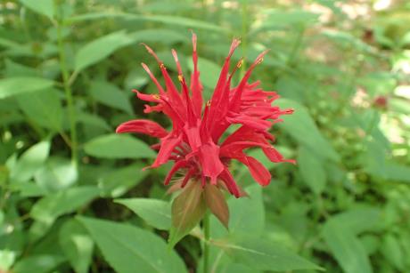 | | 2020 | COLLECTED | 09/05/2020 | Tioga State Forest Area including Stony Fork (Morris Twp), Pine Creek (Shippen Twp), and Cedar Run (Elk Twp) watersheds, southwest area of Tioga County | 41.66542100, -77.48979100 | | Localized around small creeks/tributaries, typically inhabiting wetter sites. | Wild material | Population in nature peaked flower on 6 July (2020). Flowers red. Based on historical observations (M. W. Simonis, pers. communication 8 July 2020), several previously known sites for M. didyma in Tioga County no longer exist largely due to road work and/or bridge replacements. | 2107715 | Ames 35552 |
| 120 | Ames 32966 | JDC/VA/2015/052/709 | Viburnum opulus L. var. americanum Aiton | Iowa, United States | NC7 |  | | 2015 | COLLECTED | 09/15/2015 | Yellow River State Forest, T97N R4W northern edge of SW ¼ NW ¼ Sec. 36. | 43.17778200, -91.26642800 | 239 | North-facing algific talus slope (45-60 degrees) adjacent to Paint Creek. Moist deciduous woods. | Wild material | Formerly known as Viburnum trilobum, American highbush cranberry (V. opulus var. americanum) is a North American native shrub that is utilized as an important ornamental and conservation plant that is also harvested as a minor fruit crop (jams/jellies). In nature, this variety is generally found in moist habitats typically along stream banks and swamps where ample moisture is readily available. The native range of V. opulus var. americana is concentrated in the northeastern United States and into Canada (Little, E. L. Jr. 1977). Attractive ornamental characteristics includes showy lacecap flowers in spring and bright red fruits and foliage in the fall. Fruits are tart with a hint of sweetness. The European highbush cranberry (V. opulus var. opulus) is nearly identical to American highbush cranberry other than small glands (<1 mm) on the petiole making the exact determination very challenging resulting in common misidentifications. A major difference between the American and European highbush cranberries is that the European variety produces unpalatable fruit. Recent research has shown that American and European highbush cranberries are genetically distinct and that plants of hybrid origin are uncommon (Tork et al. 2025). Vigorous early spring growth and good tolerance to late spring frosts. Genetic analysis from Tork et al. 2025 confirmed that genetics of this accession represents American highbush Cranberry (Viburnum opulus var. americanum). This accession represents genetics from northeast Iowa and thus the extreme western edge of the species native range. | 1927436 | Ames 32966 |
| 121 | W6 49533 | CBG-2474 | Osmorhiza longistylis (Torr.) DC. | Illinois, United States | W6 |  | | 2015 | | | | | | | Wild material | | 1926010 | W6 49533 |
| 122 | W6 35536 | R08-16-075 | Trifolium medium L. | Russian Federation | W6 | | | 2009 | COLLECTED | 08/14/2008 | Near Kara village, 96 km southwest of Beloretsk. District of Beloretsk. Oblast = Bashkortostan | 53.33000000, 57.43000000 | 506 | Side of road in Betula pubescens, Pinus sylvestris forest, east facing 10% slope, in vicinity of Belaya River | Wild material | | 1811714 | W6 35536 |
| 123 | W6 35544 | R08-17-083 | Lotus corniculatus L. | Russian Federation | W6 |  | | 2009 | COLLECTED | 08/14/2008 | Near Uzyan village, 82 km southwest of Beloretsk. District of Beloretsk. Oblast = Bashkortostan | 53.44000000, 57.54000000 | 487 | Ditchbank along both sides of road | Wild material | | 1811722 | W6 35544 |
| 124 | W6 35551 | R08-18-091 | Festuca rupicola Heuff. | Russian Federation | W6 | | | 2009 | COLLECTED | 08/14/2008 | Near Sertenevo village, 50 km south/southwest of Beloretsk. District of Beloretsk. Oblast = Bashkortostan | 53.55000000, 58.11000000 | 521 | South facing slope in corridor of power line and railroad | Wild material | | 1811729 | W6 35551 |
| 125 | W6 35561 | R08-20-101 | Trifolium medium L. | Russian Federation | W6 | | | 2009 | COLLECTED | 08/15/2008 | Near Abazovo village, 42 km south/southwest of Abzakovo. District of Abzakovskiy. Oblast = Bashkortostan | 53.46000000, 58.40000000 | 481 | North facing hayfield, 5% slope | Wild material | | 1811739 | W6 35561 |
| 126 | W6 35562 | R08-20-102 | Trifolium montanum L. | Russian Federation | W6 | | | 2009 | COLLECTED | 08/15/2008 | Near Abazovo village, 42 km south/southwest of Abzakovo. District of Abzakovskiy. Oblast = Bashkortostan | 53.46000000, 58.40000000 | 481 | North facing hayfield, 5% slope | Wild material | | 1811740 | W6 35562 |
| 127 | W6 35572 | R08-25-114 | Trifolium montanum L. | Russian Federation | W6 | | | 2009 | COLLECTED | 08/17/2008 | 6 km west of Stepnoye. District of Nagaybakskiy. Oblast = Chelyabinsk | 54.07000000, 60.31000000 | 345 | Reforestation area in clearing of birch/pine forest | Wild material | | 1811750 | W6 35572 |
| 128 | W6 35573 | R08-25-115 | Agrostis gigantea Roth | Russian Federation | W6 | | | 2009 | COLLECTED | 08/17/2008 | 6 km west of Stepnoye. District of Nagaybakskiy. Oblast = Chelyabinsk | 54.07000000, 60.31000000 | 345 | Reforestation area in clearing of birch/pine forest | Wild material | | 1811751 | W6 35573 |
| 129 | W6 35578 | R08-26-121 | Trifolium lupinaster L. | Russian Federation | W6 |  | | 2009 | COLLECTED | 08/18/2008 | Near Roschino village, 25 km south of Yuzhnoural'sk. District of South Ural. Oblast = Chelyabinsk | 54.22000000, 61.19000000 | 236 | Hayfield in dry valley meadow with birch scrub | Wild material | | 1811756 | W6 35578 |
| 130 | W6 35579 | R08-27-122 | Medicago sativa L. subsp. falcata (L.) Arcang. | Russian Federation | W6 | | | 2009 | COLLECTED | 08/18/2008 | 8 km southwest of Yuzhnoural'sk and 24 km south of Krasnogorsk. District of Krasnogorsk. Oblast = Chelyabinsk | 54.40000000, 61.15000000 | 254 | Along roadside and rest area of old road | Wild material | | 1811757 | W6 35579 |
| 131 | W6 35589 | R08-31-134 | Trifolium montanum L. | Russian Federation | W6 | | | 2009 | COLLECTED | 08/20/2008 | 33 km southwest of Ozersk. District of Ozerskiy. Oblast = Chelyabinsk | 55.49000000, 60.47000000 | 226 | Along roadside at margin of wet meadow hayfield, unbelievable diversity, in vicinity of Lake Irtyaga | Wild material | | 1811767 | W6 35589 |
| 132 | W6 35595 | R08-31-141 | Medicago lupulina L. | Russian Federation | W6 | | | 2009 | COLLECTED | 08/20/2008 | 33 km southwest of Ozersk. District of Ozerskiy. Oblast = Chelyabinsk | 55.49000000, 60.47000000 | 226 | Along roadside at margin of wet meadow hayfield, unbelievable diversity, in vicinity of Lake Irtyaga | Wild material | | 1811773 | W6 35595 |
| 133 | W6 35606 | R08-34-152 | Trifolium medium L. | Russian Federation | W6 | | | 2009 | COLLECTED | 08/21/2008 | Near Dalnaya Dacha village, 41 km southwest of Kyshtym. District of Kyshtymskiy. Oblast = Chelyabinsk | 55.38000000, 60.28000000 | 296 | Along power line corridor clearing, in pine-birch forest | Wild material | | 1811783 | W6 35606 |
| 134 | W6 35608 | R08-35-154 | Vicia sepium L. | Russian Federation | W6 | | | 2009 | COLLECTED | 08/21/2008 | 24 km south of Karabash. District of Karabashskiy. Oblast = Chelyabinsk | 55.24000000, 60.16000000 | 285 | Meadow area below a birch forest | Wild material | | 1811785 | W6 35608 |
| 135 | W6 35617 | R08-37-163 | Agrostis gigantea Roth | Russian Federation | W6 | | | 2009 | COLLECTED | 08/23/2008 | 3 km south of Satki. District of Satkinskiy. Oblast = Chelyabinsk | 55.02000000, 59.00000000 | 435 | North facing, 10% slope, in hay meadow on edge of birch-pine forest, in vicinity of Satki Reservoir | Wild material | | 1811793 | W6 35617 |
| 136 | W6 35642 | R08-42-190 | Festuca arundinacea Schreb. subsp. orientalis (Hack.) K. Richt. | Russian Federation | W6 |  | | 2009 | COLLECTED | 08/25/2008 | Near Bartym village, 46 km southeast of Karaidel. District of Karaidelskiy. Oblast = Bashkortostan | 55.48000000, 57.33000000 | 351 | Along drainage area in hayfield meadow in birch-pine forest, in vicinity of Bolshaya Berdyashka River | Wild material | | 1811816 | W6 35642 |
| 137 | W6 35643 | R08-42-191 | Trifolium medium L. | Russian Federation | W6 | | | 2009 | COLLECTED | 08/25/2008 | Near Bartym village, 46 km southeast of Karaidel. District of Karaidelskiy. Oblast = Bashkortostan | 55.48000000, 57.33000000 | 351 | Along drainage area in hayfield meadow in birch-pine forest, in vicinity of Bolshaya Berdyashka River | Wild material | | 1811817 | W6 35643 |
| 138 | W6 33001 | R07-12-038 | Medicago lupulina L. | Novgorod, Russian Federation | W6 | | | 2008 | COLLECTED | 08/12/2007 | Ostriokletki Village. Borovichsky district | 58.03944444, 33.57027778 | 191 | Along roadside and into abandoned field | Wild material | | 1778075 | W6 33001 |
| 139 | W6 33029 | R07-19-070 | Trifolium medium L. | Vologda, Russian Federation | W6 |  | | 2008 | COLLECTED | 08/15/2007 | Zalesye Village. Ustyuzhna district | 58.69638889, 36.16833333 | 140 | Abandoned cropland surrounded by Betula/Pinus forest | Wild material | | 1778101 | W6 33029 |
| 140 | W6 33045 | R07-24-092 | Festuca pratensis Huds. | Vologda, Russian Federation | W6 | | | 2008 | COLLECTED | 08/17/2007 | Chaevo Village. Cherepovets district | 58.91916667, 37.22277778 | 111 | Regrowth vegetation under high-voltage power line | Wild material | | 1778117 | W6 33045 |
| 141 | W6 33058 | R07-27-106 | Festuca pratensis Huds. | Yaroslavl, Russian Federation | W6 | | | 2008 | COLLECTED | 08/18/2007 | Malofeevo Village. Poshehonsky district | 58.67666667, 38.54638889 | 111 | Abandoned field surrounded by pine/birch forest | Wild material | | 1778130 | W6 33058 |
| 142 | W6 33062 | R07-28-111 | Trifolium hybridum L. | Yaroslavl, Russian Federation | W6 |  | | 2008 | COLLECTED | 08/18/2007 | Shahovka Village. Poshehonsky district | 58.50916667, 38.97527778 | 115 | Regrowth vegetation under high-voltage power line with pine/birch/Alnus forest | Wild material | | 1778134 | W6 33062 |
| 143 | W6 33064 | R07-29-114 | Phalaris arundinacea L. | Yaroslavl, Russian Federation | W6 | | | 2008 | COLLECTED | 08/19/2007 | Lapushka Village. Poshehonsky district | 58.35861111, 39.04027778 | 115 | Along edges of mowed hayfield, surrounded by Pinus/Betula forest | Wild material | | 1778136 | W6 33064 |
| 144 | W6 33072 | R07-30-123 | Vicia sativa L. | Yaroslavl, Russian Federation | W6 |  | | 2008 | COLLECTED | 08/19/2007 | Dymovskoye Village. Rybinsk district | 58.19666667, 38.85833333 | 119 | Along edge of hayfield surrounded by Betula/Alnus forest | Wild material | | 1778144 | W6 33072 |