| 0 | NA 83131 | 'Pink Pom Poms' | Cercis canadensis L. | | NA | | | 2016 | | | | | | | Cultivar | | 2115990 | NA 83131 |
| 1 | NA 82894 | 'NCCC1' | Cercis canadensis L. var. canadensis | | NA | | | 2015 | | | | | | | Cultivar | | 1951162 | NA 82894 |
| 2 | WLP 815 | JDC/CC/2009/095/245 | Cercis canadensis L. | Ohio, United States | NA | | | 2009 | COLLECTED | 10/16/2009 | Near Five Forks, SW 1/4 of SE 1/4 of Section 29, T4N, R17W, Kitts Hill Quad, Lawerence County. | 38.61555556, -82.55611111 | 285 | Dry, rocky substrate. West and south facing slope. Associated with Acer saccharum, Fraxinus americana, Quercus, and Rhus. | Wild material | | 1823917 | WLP 815 |
| 3 | WLP 783 | RL 08030 | Cercis canadensis L. | | NA | | | 2008 | COLLECTED | PRE 09/08/2008 | North Carolina, Haywood County, Harmon Den, along Forest Service road and west side of I-40. | 35.73613000, -83.02461000 | | | Wild material | | 1896045 | WLP 783 |
| 4 | WLP 780 | GR-07-03 | Cercis canadensis L. | | NA | | | 2007 | COLLECTED | PRE 10/29/2007 | Maryland, Allegany County, Green Ridge State Forest on Piclic Road | 39.67461000, -78.48491000 | | woodland edge on ridge of mountain | Wild material | | 1895942 | WLP 780 |
| 5 | WLP 772 | NA 73815 | Cercis canadensis L. | Iowa, United States | NA |  | | 2004 | COLLECTED | 09/22/2003 | West of Ely Ford, Lacey-Keosauqua State Park, Keosauqua, T68N R10W, NE 1/4 of SE 1/4, Section 3, Keosauqua Quad, Van Buren County. | 40.71666667, -91.99055556 | 177 | Edge of trail and parking area, floodplain forest. Half sunny. Flat slope. Associated with Toxicodendron, Celtis, Vitis (not riparia), and Symphoricarpos orbiculatus. | Wild material | | 1897399 | WLP 772 |
| 6 | WLP 920 | 35 | Cercis canadensis L. | Iowa, United States | NA |  | | 2003 | COLLECTED | 09/24/2003 | Bluff Park, Keokuk, South of Park Street at G, T65N R5W, Section 35, Keokuk Quad, Lee County. | 40.38861111, -91.40277778 | 194 | Bluff edge along Mississippi River. Sunny. 0-25% slope w/ S aspect. Soil well to good drainage. Assoc w/ Campsis radicans, Quercus muehlenbergii, Eupatorium (white snakeroot and tall boneset), Solidago, Lonicera maackii, and Catalpa. | Wild material | Small trees. Possibly wild, possibly originally cultivated, but Cercis very common in area, growing in city park. | 1649668 | WLP 920 |
| 7 | DLEG 950004 | DLEG 950004 | Cercis canadensis L. | Texas, United States | | | Historic | 1995 | COLLECTED | 01/01/1995 | Bexar Co., Hemisphere Park, San Antonio. | | | | Cultivated material | Received from Drs. Edmund and Jean Weber. | 1527713 | DLEG 950004 |
| 8 | WLP 750 | SB 104 | Cercis canadensis L. | Oklahoma, United States | NA | | | 1994 | COLLECTED | | | 35.30809000, -98.71579000 | 470 | | Wild material | Habitat: roadside | 1493165 | WLP 750 |
| 9 | DLEG 920008 | DLEG 920008 | Cercis canadensis L. var. canadensis | Virginia, United States | | | Historic | 1992 | COLLECTED | 1991 | Gloucester Co. | | | | Wild material | | 1527167 | DLEG 920008 |
| 10 | DLEG 920272 | DLEG 920272 | Cercis canadensis L. | Virginia, United States | | | Historic | 1992 | COLLECTED | 09/14/1992 | Gloucester Co., Rt. 614 near floodgate ate Hayne's Mill. | | | On steep dry hillside growing with Carya, Quercus, Cornus florida. | Wild material | Received from Joe Brown. | 1526763 | DLEG 920272 |
| 11 | DLEG 910010 | DLEG 910010 | Cercis canadensis L. var. canadensis | North Carolina, United States | | | Historic | 1991 | COLLECTED | 12/1990 | Chapel Hill. | | | | | Small tree; papery pods with 1-4 seeds per pod. Received from Dr. L. W. Dewhirst. | 1526427 | DLEG 910010 |
| 12 | NA 63279 | NG 26 | Cercis canadensis L. | Tennessee, United States | NA | | | 1991 | COLLECTED | 10/08/1991 | Tennessee, Van Buren County, On Hwy. 30, about 5 mi. east of Spencer | | | Woodland, west facing slope of mountainside. | Wild material | | 1494732 | NA 63279 |
| 13 | DLEG 900371 | DLEG 900371 | Cercis canadensis L. var. mexicana (Rose) M. Hopkins | Texas, United States | |  | Historic | 1990 | COLLECTED | 07/12/1990 | Terrell Co., Hwy 285, 14.3 mi. N of Sanderson. | | | Draw on E side of limestone hill with Ungnadia speciosa, Celtis reticulata, Rhus microphylla, Eysenhardtia texana, Acacia roemeriana, A. constricta, Prosopis glandulosa, Dasylirion leiophyllum. | Wild material | Unarmed, multiple-stemmed trees to 6 m tall; simple, heart-kidney shaped leaves; showy red flowers. M. Johnson 90-050. | 1526469 | DLEG 900371 |
| 14 | DLEG 890416 | DLEG 890416 | Cercis canadensis L. var. canadensis | United States | | | Historic | 1989 | COLLECTED | | | | | | | Received from F. W. Schumacher Co., Inc. | 1526404 | DLEG 890416 |
| 15 | NA 64744 | Ames 7635 | Cercis canadensis L. | Pennsylvania, United States | NA | | | 1985 | COLLECTED | | Chester County, PA | 39.98445900, -75.75008400 | | | Wild material | | 1040589 | NA 64744 |
| 16 | NA 64741 | Ames 2921 | Cercis canadensis L. | Minnesota, United States | NA | | | 1984 | COLLECTED | | Horticulture Research Center near Victoria | 44.86733600, -93.63600200 | | | Cultivated material | | 1022557 | NA 64741 |
| 17 | NA 64727 | Ames 2869 | Cercis canadensis L. | Indiana, United States | NA | | | 1984 | COLLECTED | | Posey County, IN | 37.80000000, -87.95000000 | 110 | | Wild material | | 1022304 | NA 64727 |
| 18 | NA 64728 | Ames 2870 | Cercis canadensis L. | Iowa, United States | NA | | | 1984 | COLLECTED | | Lee County, IA | 40.60000000, -91.70000000 | 182 | | Wild material | | 1022309 | NA 64728 |
| 19 | NA 64731 | Ames 2874 | Cercis canadensis L. | North Carolina, United States | NA | | | 1984 | COLLECTED | | Orange County, NC | 35.91666667, -79.06666667 | 121 | | Wild material | | 1022332 | NA 64731 |
| 20 | NA 64735 | Ames 2879 | Cercis canadensis L. | Iowa, United States | NA | | | 1984 | COLLECTED | | Fremont County, IA | 40.61666667, -95.65000000 | 281 | | Wild material | | 1022364 | NA 64735 |
| 21 | WLP 748 | Ames 2877 | Cercis canadensis L. | Indiana, United States | NA | | | 1984 | COLLECTED | | Gibson County, IN | 38.33333333, -87.50000000 | | | Wild material | | 1022353 | WLP 748 |
| 22 | PI 664897 | JDC/PV/2008/061/131 | Prunella vulgaris L. | Illinois, United States | NC7 |  | | 2008 | COLLECTED | 10/12/2008 | Along 2150 North Road, east of Irvington, SW 1/4 of NE 1/4 of Section 15, T1S, R1E, Walnut Hill Quad, Jefferson County. | 38.43833333, -89.07833333 | 161 | Only on south side of road; northern exposure; mostly shaded due to woody vegetation. | Wild material | | 1788218 | PI 664897 |
| 23 | PI 664818 | PA2 | Actaea racemosa L. | Pennsylvania, United States | NC7 | | | 2005 | | | | | | | Wild material | | 1698895 | PI 664818 |
| 24 | Ames 38800 | Camp Mitigwa | Amelanchier arborea (F. Michx.) Fernald | Iowa, United States | NC7 |  | | 2026 | COLLECTED | 06/01/2026 | Mitigwa Scout Camp located on west side of Des Moines River watershed approximately 7.50 miles south, southwest of Boone, T82N R26W N 1/4 Sec. 5 and T83N R26W S 1/4 Sec. 32. | 41.94894500, -93.90537200 | 310 | High-quality white oak - ironwood, mature woods. | Wild material | The native range of Amelanchier arborea is concentrated in the eastern half of the U.S. (Little, 1977). This accession represents a collection of A. arborea germplasm from the western edge of the species native range, specifically central Iowa. Specimens sampled at the collection site in nature were small to medium understory or woodland edge single and/or multi-trunked trees with a few trees getting close to being deemed as canopy specimens. Bark smooth and light grey in color. Specimens sampled in nature ranging 15-50' in height. Peak flowering occurred on 8 April 2026 with white flowers appearing prior to leaf expansion. Fall colors ranging from orange to orange-red peaking typically at the end of September (central Iowa). Fruits, dark-pink to red, maturing in early June (peak in 2026 occurred on 2 June) averaging 8 mm in diameter, except for mother tree #6 that had rather large fruits at 11 mm in diameter. | 2197049 | Ames 38800 |
| 25 | NA 89115 | TLM25-04a | Hamamelis ovalis S. W. Leonard | Texas, United States | NA | | | 2025 | COLLECTED | 07/10/2025 | State Highway 87 approximately 3.25 kilometers north of the crossroad junction with Texas Recreational Road 255 (RE 255); plants were growing in the narrow buffer woods along the east side of the highway. | 31.12051300, -93.72628100 | 138 | The habitat is an upland mixed coniferous and deciduous woodlands in part to full shade and dry conditions, often under drought stress. Plants seem to always occur on the top of dry ridges or well-drained slopes. Slope: 0 to 1 percent. Aspect: N/A. Soils: The soils of this collection area are classified as Tehran-Letney Association, hilly (TLE) soils. The Tehran Series (55%) consists of deep, somewhat excessively drained, moderately rapidly permeable soils on uplands. They formed in thick loamy and sandy sediments on the Western Coastal Plain. These soils are on gently sloping to moderately steep uplands with slopes ranging from 1 to 20 percent. The Letney Series (30%) consists of deep, well drained, moderately rapidly permeable, upland soils. They formed in thick sandy and loamy sediments of the coastal plains. These soils are on gently sloping to moderately steep uplands with slopes ranging from 1 to 20 percent. Soil pH ranges from 4.5 to 6.0. The minor soil components include Doucette Series (10%) and Boykin Series (5%) soils. (Source: California Soil Resource Lab/NRCS Official Soil Series Descriptions). Geology: The underlying geology of this area is of Oligocene origin and characterized as Catahoula Formation. This formation is extensive and deep in Texas, up to 185 meters thick. In the area of the collection the Catahoula Formation is primarily mudstone and sand. The upper 90-150 meters is mudstone that is tuffaceous, and sandy; also, occasionally, with some bentonitic clay. (Source: USGS Texas Geologic Map Data). | Wild material | | 2191654 | NA 89115 |
| 26 | WLP 3492 | St. Francois State Park | Hydrangea arborescens L. | Missouri, United States | NA |  | | 2024 | COLLECTED | 01/19/2024 | St. Francois State Park, 8920 US Highway 67 North, approximately 3.2 miles north-northeast of Bonne Terre. | 37.96381000, -90.53403000 | 202 | Rocky outcrops above Big River and rocky areas on bank of Big River. | Wild material | | 2166135 | WLP 3492 |
| 27 | OPGC 8853 | JDC/AA/2023/078/1110 | Arnoglossum atriplicifolium (L.) H. Rob. | Iowa, United States | OPGC | | | 2023 | COLLECTED | 09/21/2023 | Iowa Army Ammunition Plant located 5.09 miles southwest of Burlington along south side of road, Union Township T69N R3W SE 1/4 SE 1/4 SW 1/4 Sec. 7 | 40.78416600, -91.24800000 | 191 | Woodland edges/roadsides. | Wild material | | 2159005 | OPGC 8853 |
| 28 | NA 88628 | KY23-031 | Rhododendron arborescens (Pursh) Torr. | Kentucky, United States | NA | | | 2023 | COLLECTED | 09/11/2023 | Daniel Boone National Forest: Bee Rock Loop Trail along Rockcastle River. | 37.03497974, -84.30580649 | 229 | Riverscour grassland, edge of river, river scour/boulder pile. Elevation: 750 feet. Aspect: Southeast. | Wild material | | 2158720 | NA 88628 |
| 29 | NA 88630 | KY23-033 | Rhododendron periclymenoides (Michx.) Shinners | Kentucky, United States | NA | | | 2023 | COLLECTED | 09/11/2023 | Daniel Boone National Forest: Bee Rock Loop Trail along Rockcastle River. | 37.03537000, -84.30551000 | 229 | Riverscour grassland, edge of river, river scour/boulder pile. Elevation: 750 feet. Aspect: Southeast. | Wild material | Initial identification: Rhododendron periclymenoides aff. | 2158722 | NA 88630 |
| 30 | NA 88652 | KY23-056 | Euonymus atropurpureus Jacq. | Kentucky, United States | NA | | | 2023 | COLLECTED | 09/14/2023 | Floracliff Nature Sanctuary. | 37.90131000, -84.36057000 | 262 | [Downslope from] KY-054 [WLP 3199, Symphoricarpos orbiculatus] and KY-055 [WLP 3200, Ptelea trifolia. ] Elevation: 858 feet. Aspect: West. | Wild material | | 2158745 | NA 88652 |
| 31 | Ames 36170 | Lake Catherine State Park | Ptelea trifoliata L. | Arkansas, United States | NC7 |  | | 2023 | COLLECTED | 08/27/2023 | Lake Catherine State Park approximately 10 miles southeast of Hot Springs. Localized to the ridge top of Dam Mountain on the south shore of the southeast arm of the reservior, starting approximately 0.25 miles southwest of the dam. T3S R18W Sec. 35. | 34.42452200, -92.90218400 | 199 | Dry ridge top. Predominantly on the north facing edge of ridge. | Wild material | A localized but very dense population. Ptelea is the dominant understory species in this location. | 2158789 | Ames 36170 |
| 32 | NA 89233 | UK Arb. 2023-0059-A | Cladrastis kentukea (Dum. Cours.) Rudd | Kentucky, United States | NA | | | 2023 | COLLECTED | 08/22/2023 | Blue Sportsmen's League (land owner): trees growing on both sides of eroded dirt road from campground to Kentucky River. | 37.78777000, -84.65356000 | | Calcareous rocky woods, mid-slope. Slope: 20-30%. Aspect: Southwest. | Wild material | | 2158476 | NA 89233 |
| 33 | Ames 36152 | JDC/MM/2023/048/1080 | Monarda maxmedleyi J. J. N. Campb. & Floden | Kentucky, United States | NC7 |  | | 2023 | COLLECTED | 08/10/2023 | Owsley Fork Road (roadsides) just 2.3 miles east, southeast of Big Hill, along the north edge of the reservior. | 37.54038300, -84.17209500 | 252 | Moist and dry slopes. Woodland edges; open woods; densely shaded woods; and wooded roadsides. | Wild material | Plants measuring 12-18" in height. Spreading vegetatively via rhizomes. Flower color on the majority of specimens is mostly white with some specimens having a hint of pink. Peak flowering at collection site occurred near 28th of May (2023). Some specimens flowering in heavy shade. | 2158357 | Ames 36152 |
| 34 | Ames 36153 | JDC/MM/2023/049/1081 | Monarda maxmedleyi J. J. N. Campb. & Floden | Kentucky, United States | NC7 |  | | 2023 | COLLECTED | 08/10/2023 | Lily Mountain Preserve located 6.92 miles west, southwest of South Irvine | 37.63661300, -84.09026400 | 432 | Open dry, woods. Localized at highest elevations of preserve. | Wild material | Plants measuring 12-18" in height. Spreading vegetatively via rhizomes. Majority of specimens with mostly white flowers. Peak flowering at collection site occurred near 26th of May (2023). | 2158358 | Ames 36153 |
| 35 | Ames 36154 | JDC/MM/2023/051/1083 | Monarda maxmedleyi J. J. N. Campb. & Floden | Kentucky, United States | NC7 |  | | 2023 | COLLECTED | 08/08/2023 | Located just east of highway 213 (Morris Creek Road) near Powell and Montgomery County line. Population in both counties. | 37.90554800, -83.86808700 | 359 | Dry, steep hillside (roadside). Localized to south-facing slopes. | Wild material | Plants measuring 12-18" in height. Peak flowering at collection site occurred near 24th of May (2023). Some specimens extremely vigorous forming dense clonal patches covering a 5' x 5' area. Majority of specimens with mostly white flowers. | 2158359 | Ames 36154 |
| 36 | Ames 36155 | JDC/MM/2023/052/1084 | Monarda maxmedleyi J. J. N. Campb. & Floden | Kentucky, United States | NC7 |  | | 2023 | COLLECTED | 08/09/2023 | Star Gap Road between Red River and Campton Road located 3.0 miles north, northwest of Slade | 37.83158300, -83.72674500 | 265 | Edges of woods/roadsides. Localized to west and southeast facing slopes. | Wild material | Plants measuring 12-18" in height. Spreading vegetatively via rhizomes. Most specimens had pale pink flowers with some having white flowers. Peak flowering at collection site occurred near 29th of May (2023). | 2158360 | Ames 36155 |
| 37 | Ames 36157 | JDC/MM/2023/054/1086 | Monarda maxmedleyi J. J. N. Campb. & Floden | Kentucky, United States | NC7 |  | | 2023 | COLLECTED | 08/08/2023 | Located along Nichols Branch Road and Dry Creek Road, 2.0 miles east of Clearfield both north and south of Dry Creek Road intersection | 38.14977900, -83.38992200 | 259 | Localized to south and west-facing moist slopes with steep (65 degree) slopes. | Wild material | Plants measuring 12-18" in height. Spreading vegetatively via rhizomes. Near split of white and light pink flowered specimens. Peak flowering at collection site occurred near 25th of May (2023). | 2158362 | Ames 36157 |
| 38 | Ames 36158 | JDC/MM/2023/058/1090 | Monarda maxmedleyi J. J. N. Campb. & Floden | Kentucky, United States | NC7 |  | | 2023 | COLLECTED | 08/09/2023 | South of Morehead approximately 5.8 miles on Pretty Ridge Road (highway 1274) just north of intersection with Road 801 | 38.10409000, -83.42610600 | 353 | Roadside. High-quality remnant prairie/open woods in immediate area. | Wild material | Plants measuring 12-18" in height. Spreading vegetatively via rhizomes. Majority of specimens with light pink flowers but a few have white flowers. Peak flowering at collection site occurred near 25th of May (2023). | 2158363 | Ames 36158 |
| 39 | Ames 36161 | JDC/MM/2023/066/1098 | Monarda maxmedleyi J. J. N. Campb. & Floden | Kentucky, United States | NC7 | 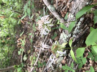 | | 2023 | COLLECTED | 08/09/2023 | Daniel Boone National Forest on west and east side of NF-227 (Sweet Lick Road) just north (0.65 miles) of intersection with Henry Ridge Road | 37.74303300, -83.93589700 | 387 | Ridge tops/highest elevations, dry open woods. | Wild material | Plants measuring 8-14" in height. Spreading vegetatively via rhizomes. Population mostly represented as specimens with white flowers. Peak flowering at collection site occurred near 27th of May (2023). | 2158366 | Ames 36161 |
| 40 | OPGC 8851 | AS/OF/2023/068/278 | Oenothera fruticosa L. subsp. glauca (Michx.) Straley | Kentucky, United States | OPGC |  | | 2023 | COLLECTED | 08/09/2023 | Star Gap Road between Red River and Campton Road located 3.0 miles north, northwest of Slade | 37.83158300, -83.72674500 | 260 | Edges of woods/roadsides. Localized to west and southeast facing slopes. | Wild material | Plants in nature measuring approximately 3.0' in height. Bright yellow flowers peaking in early June (central Kentucky) measuring approximately 1-2" across. | 2158361 | OPGC 8851 |
| 41 | Ames 36139 | Berea College Forest | Morus rubra L. | Kentucky, United States | NA |  | | 2023 | COLLECTED | 05/31/2023 | Between West and East Pinnacles of Berea College Forest just 3.25 miles east, southeast of Berea | 37.55656100, -84.23777600 | 338 | Mid-lower slopes of moist, deciduous woods. | Wild material | Species rather abundant throughout site with little to no presence of Morus alba. Majority of specimens noted measuring 8" DBH or smaller. Largest specimen noted reaching approximately 60' in height. | 2158344 | Ames 36139 |
| 42 | NA 87354 | TJK2022TX-002 | Ptelea trifoliata L. | Texas, United States | NA | | | 2023 | COLLECTED | 11/29/2022 | Blanco County: Little Blanco Road, upper slope off Little Blanco River; 330 feet west of Highway 281. | 30.00140000, -98.40650000 | 390 | Shaded streamside slope between road and Little Blanco River. | Wild material | | 2141645 | NA 87354 |
| 43 | WLP 2614 | 2022VA-05 | Euonymus americanus L. | Virginia, United States | NA | | | 2022 | COLLECTED | 09/12/2022 | In Colonial Williamsburg, park in the Providence Hall Directors Wing parking lot and enter the Bassett Trace Nature Trail; this species is found in the woodlands on either side of the trail and over a bridge until the it turns right. This plant is infrequent, but occasionally found in the mesic woodlands throughout this location. | 37.26681600, -76.69252800 | 21 | Plants growing in shade to part-shade of the mixed deciduous and evergreen mesic woodland. This species is generally growing in areas with an abundant organic, mature woodland that is relatively undisturbed.
The underlying geology of this area is Windsor Formation of Tertiary-Quaternary origin (lower Pleistocene or upper Pliocene). It is comprised of gray and yellowish- to reddish-brown sand, gravel, silt, and clay. It constitutes surficial deposits of extensive plain and fluvial-estuarine terraces above elevations of 10 meters. The thickness of the Windsor Formation is 0 to 12.5 meters.
Source: USGS Virginia Geologic Map Data (https://mrdata.usgs.gov/geology/state/sgmc-unit.php?unit=VAQTw%3B0)
The surface soil profile of this area is Emporia Complex, 15 to 25 percent slopes. This soil as moderately well-drained, acidic, and found on sloping and elevated terraces. They are comprised of fine sandy loam, loam, and sandy clay loam in varying quantities across the profile; the depth to parent geology is approximately 200 cm.
Source: NRCS Web Soil Survey (https://websoilsurvey.sc.egov.usda.gov/App/WebSoilSurvey.aspx) | Wild material | | 2139352 | WLP 2614 |
| 44 | OPGC 7574 | Ledges State Park | Solidago ulmifolia Muhl. ex Willd. | Iowa, United States | OPGC |  | | 2021 | COLLECTED | 09/15/2021 | Ledges State Park, approximately 4.5 miles south of Boone, T83N R26W Sec. 20 | 41.98266200, -93.89314800 | 287 | Understory of hardwood forest. | Wild material | Plants in nature were generally two to three feet in height, growing in sparsely spreading colonies. This population has a large amount of diversity for flowering time with the first plants in the population beginning to flower on 22 July 2021 and the last plants to flower were still blooming at the end of September. Some plants in the population had a muted red fall foliage color at the end of October 2021. This accession represents genetics from near the northwest edge of the species range of occurence. | 2132828 | OPGC 7574 |
| 45 | OPGC 7575 | Ledges State Park | Solidago flexicaulis L. | Iowa, United States | OPGC |  | | 2021 | COLLECTED | 10/03/2021 | Ledges State Park, approximately 4.5 miles south of Boone, T83N R26W Sec. 21 | 41.98338100, -93.89052800 | 288 | Understory of hardwood forest. | Wild material | Plants in nature ranged in height from approximately one to three feet, growing in sparsely spreading colonies. Peak bloom in 2021 occurred near 15 September. Several specimens had branched inflorescences. | 2132829 | OPGC 7575 |
| 46 | W6 59274 | CBG-10598 | Scrophularia marilandica L. | Illinois, United States | W6 | | | 2021 | | | | | | | Wild material | Plant numbers sampled estimated. | 2120183 | W6 59274 |
| 47 | NA 86848 | ZARKS-025 | Acer saccharum Marshall subsp. leucoderme (Small) Desmarais | Arkansas, United States | NA | | | 2020 | COLLECTED | 10/09/2014 | Cedar Fourche Creek; Harper Grocery Rd. at Rock Springs Rd. | 34.66470800, -93.26778900 | 209 | Mesic, mixed deciduous forest; growing on the bank just above a small stream | Wild material | | 2115797 | NA 86848 |
| 48 | Ames 35288 | APS/MF/2020/003/406 | Monarda fistulosa L. | Kansas, United States | NC7 |  | | 2020 | COLLECTED | 02/05/2020 | Eisenhower State Park on north side of Melvern Lake approximately 5.25 miles west, northwest of Melvern, T18S R15E NE1/4 Sec. 3, Osage County | 38.51966000, -95.73352000 | 323 | Edge of woods with limestone substrate. | Wild material | | 2101394 | Ames 35288 |
| 49 | WLP 2501 | Tishomingo State Park | Hydrangea quercifolia W. Bartram | Mississippi, United States | NA |  | | 2019 | COLLECTED | 12/15/2017 | Tishomingo State Park, Tishomingo County, along Natchez Trace National Parkway. Approximately 2.3 mi west of Mississippi/Alabama state line. | 34.59989600, -88.18538400 | | Rocky roadsides, hillsides and outcrops. | Wild material | Plants were abundantly flowering in 2017. Many were growing as small trees with one to three trunks. | 2106211 | WLP 2501 |
| 50 | WLP 2503 | Jeff Busby Park | Hydrangea quercifolia W. Bartram | Mississippi, United States | NA |  | | 2019 | COLLECTED | 12/16/2017 | Jeff Busby Park, Choctaw County, along Natchez Trace National Parkway. 8.4 miles south of Eupora. | 33.41567000, -89.26402200 | | Steep slopes on mountainside, steep roadsides, ravines. | Wild material | Specimens in nature represented as dense, clonaly spreading colonies with abundant flowering. A few plants had persistent leaves on 16 December 2017. | 2106213 | WLP 2503 |
| 51 | WLP 2524 | Coon Creek Forever Wild Tract | Hydrangea quercifolia W. Bartram | Alabama, United States | NA |  | | 2019 | COLLECTED | 11/29/2018 | Coon Creek Forever Wild Tract, Tallapoosa County. Approximately 4.25 miles north-northeast of Tallassee, near the confluence of Coon Creek with the Tallapoosa River. | 32.59593400, -85.88035200 | | Steep streambank. | Wild material | Measurements of sampled specimens taken in nature: Height 87 to 152 in.; width 66 to 124 in. Measurements for each specimen sampled may be provided upon request. | 2106234 | WLP 2524 |
| 52 | WLP 2529 | Buck's Pocket State Park | Hydrangea quercifolia W. Bartram | Alabama, United States | NA |  | | 2019 | COLLECTED | 12/15/2018 | Buck's Pocket State Park, DeKalb County, 20 miles west-northwest of Forth Payne. | 34.47262200, -86.05294300 | | Shady slopes. | Wild material | Measurements of sampled specimens taken in nature: Height 53 to 114 in.; width 54 to 166 in. Measurements for each specimen sampled may be provided upon request. | 2106239 | WLP 2529 |
| 53 | Ames 35242 | APS/EA/2019/046/375 | Euonymus atropurpureus Jacq. | Missouri, United States | NC7 |  | | 2019 | COLLECTED | 11/02/2019 | Mule Shoe Conservation Area along CR 66 approximately 7.5 miles east of Cross Timbers. | 38.01203000, -93.09312000 | 265 | Roadside, deciduous forest. | Wild material | | 2097787 | Ames 35242 |
| 54 | WLP 160 | NACPEC19-038 | Callicarpa americana L. | Tennessee, United States | NA | | | 2019 | COLLECTED | 09/12/2019 | Marion County; Tennessee River Gorge Trust: Pot Point Nature Trail | 35.07981400, -85.38795600 | 256 | Mixed mesophytic forest: Oak-Hickory-Pine woodland; "Butterfly meadow": Goldenrod, Bluestem, Swamp Milkweed, Ironweed. | Wild material | | 2110472 | WLP 160 |
| 55 | Ames 35226 | Ocoee Gorge | Monarda austroappalachiana Floden | Tennessee, United States | NC7 |  | | 2019 | COLLECTED | 09/12/2019 | Located just east of Lake Ocoee along highway 74 approximately 9.8 miles east, southeast of Ocoee, Polk County | 35.09659000, -84.54762000 | 269 | Steep (some vertical) rocky cliffs and bluffs, predominately shale. | Wild material | Described by Aaron Floden (2015) as an erect perennial (30-50 cm tall) with a strong Oregano (thymol) scent, minute retrorse to spreading trichomes at internodes and large, emaculate, white corollas. Typically flowers in late May into early June, which is earlier than both M. fistulosa and M. clinopodia where sympatric. Species is endemic to the Southern Appalachians (northern Georgia, southwest North Carolina, and southeast Tennessee) and limited to calcareous phyllite and limestone, glade-like/talus slope habitats. | 2097762 | Ames 35226 |
| 56 | Ames 34606 | JDC/MB/2019/011/890 | Monarda brevis (Fosberg & Artz) Floden | West Virginia, United States | NC7 |  | | 2019 | | | | | | | Wild material | Variation in flower color present from near white, faint pink to faint "smoky" purple. Majority of specimens noted at collection site in nature were approximately 3-5 days past peak flower on 10 June 2019 with seeds reaching maturity approximately 55 days later. Majority of specimens observed were approximately 10" in height. Very healthy, dark-green leaves that maintained quality throughout the season (observed mid-August 2019). Some specimens consisting of 25-30 flowering stems encompassing a 1.5 sq. ft. area. | 2092642 | Ames 34606 |
| 57 | Ames 34607 | JDC/MB/2019/012/891 | Monarda brevis (Fosberg & Artz) Floden | West Virginia, United States | NC7 |  | | 2019 | | | | | | | Wild material | This accession likely represents the holotype for Monarda brevis that was vouchered by Lena Artz in 1953 (Catalog No. 2097485). Variation in flower color present from near white, faint pink to faint "smoky" purple. Majority of specimens noted at collection site in nature were approximately 3-5 days past peak flower on 10 June 2019 with seeds reaching maturity approximately 55 days later. Majority of specimens observed were apprxoimately 10" in height. Very healthy, dark-green leaves that maintained quality throughout the season (observed mid-August 2019). | 2092643 | Ames 34607 |
| 58 | Ames 34608 | JDC/MB/2019/013/892 | Monarda brevis (Fosberg & Artz) Floden | West Virginia, United States | NC7 |  | | 2019 | | | | | | | Wild material | Majority of specimens noted at collection site in nature were approximately 5-7 days past peak flower on 11 June 2019 with seeds reaching maturity approximately 55 days later. Very healthy, dark-green leaves near peak flowering with some minor decline in leaf quality later in the season (observed mid-August 2019). Majority of specimens less than 10" in height. A few specimens with noteable hairs on stems, specifically near soil line. | 2092644 | Ames 34608 |
| 59 | Ames 34610 | JDC/MB/2019/015/894 | Monarda brevis (Fosberg & Artz) Floden | West Virginia, United States | NC7 |  | | 2019 | | | | | | | Wild material | Many genets noted at collection site in nature consisted of 25-30 stems, but individual stems are widely spaced (e.g. 1-5") apart compared to other populations (four) noted (2019 reconnaisance) where stem spacing was typically observed at 0.25-0.5" apart. Very healthy, dark-green leaves noted in early/mid June, but leaf quality greatly declined when observed in mid-August in contrast to other populations observed in nature that seemed to maintain leaf quality throughout the season. Many plants at this site were defoliated likely due to disease (leaf spot) or tattered likely due to possible insect feeding. Specimens noted were circa 10-12 days from initiation of flowering on 12 June 2019 and during mid-August a few specimens were still observed flowering with about 10-20% of infructescences were still green. The overall phenology of this M. brevis population at this site is quite different in comparison to other populations (four) observed in 2019, with flowering being much later (e.g. 10-25 days); leaf quality lower; and synchronization of flowering extremely variable within genets of this population. | 2092646 | Ames 34610 |
| 60 | Ames 34309 | JDC/ES/2018/036/849 | Echinacea sanguinea Nutt. | Texas, United States | NC7 |  | | 2018 | COLLECTED | 07/18/2018 | Private property located 4.35 miles south, southwest of Daingerfield off County Road 2215. Locally known as "Kennedy Mountain", Morris County | 32.97217700, -94.74721600 | 152 | Open, dry, recently clear cut area. | Wild material | Plants in peak flower on 22 May 2018 and seeds likely reached peak maturity around 1 July 2018. Peduncles at time of collection (17 July 2018) were showing 6-18" of brown/dead tissue. Plants ranging from 2-4.0' in height. | 1964616 | Ames 34309 |
| 61 | Ames 34302 | JDC/EP/2018/044/857 | Echinacea paradoxa (Norton) Britton | Missouri, United States | NC7 |  | | 2018 | COLLECTED | 07/03/2018 | Drury-Mincy Conservation Area just off Gunnison Road (west side) located approximately 8.5 miles southeast of Branson, T22N R20W W 1/4 SE 1/4 Sec. 16, Taney County | 36.55268100, -93.10969300 | 302 | Open, dry glade. | Wild material | | 1964609 | Ames 34302 |
| 62 | Ames 34303 | JDC/MB/2018/047/860 | Monarda bradburiana L. C. Beck | Missouri, United States | NC7 |  | | 2018 | COLLECTED | 07/03/2018 | Drury-Mincy Conservation Area just off Gunnison Road (west side) located approximately 8.5 miles southeast of Branson, T22N R20W W 1/4 SE 1/4 Sec. 16, Taney County | 36.55268100, -93.10969300 | 302 | Open, dry glade. | Wild material | | 1964610 | Ames 34303 |
| 63 | Ames 34161 | Ames 34161 | Actaea racemosa L. | Ohio, United States | NC7 |  | | 2018 | COLLECTED | 10/27/2017 | Located approximately 2.3 miles south of South Bloomingville on Goose Creek Road just north of intersection of Lowery Road, T11N R18W NE ¼ Sec. 32 Wellston Quad., Hocking County. | 39.38463100, -82.59760000 | 249 | Moist, deciduous woods adjacent to small drainage likely sourced via underground seep. | Wild material | Peak flowering occurring near 07/13/2017. Seeds were just past peak for seed collecttion at time of harvest. 10/27/2017. Species rather rare in area. | 1957727 | Ames 34161 |
| 64 | NA 85961 | PCC15-SEUSA025 | Quercus boyntonii Beadle | Alabama, United States | NA | | | 2017 | COLLECTED | 10/28/2015 | Shelby County; Birmingham; Off parking lot of EBSCO Industries, Inc., located at 5724 US-280, Birmingham, Alabama. | 33.37888000, -86.67333000 | | Ridge of Appalachian forest. | Wild material | | 2109093 | NA 85961 |
| 65 | Ames 33976 | JDC/BX/2017/029/783 | Baptisia aberrans (Larisey) Weakley | Tennessee, United States | NC7 |  | | 2017 | COLLECTED | 07/07/2017 | Just east of Murfreesboro off Factory Road, Rutherford County. | 35.85458800, -86.29682300 | 207 | Remnant cedar glade recently cleared of woody vegetation resulting in flowering of numerous native plants. | Wild material | Plants in cultivation (central Iowa) measuring 0.16 m tall x 0.42 m wide with leaflets oriented in a vertical plane; petioles 2.0-3.0 mm long; leaflets 2.2-2.3 cm long and 1.1-1.2 cm wide; fertile stems 0.42 m tall with leafy branches spreading horizontally. Flowers dark purple peaking in late May (central Iowa) when grown in cultivation. | 1950059 | Ames 33976 |
| 66 | Ames 33978 | JDC/FQ/2017/030/784 | Fraxinus quadrangulata Michx. | Tennessee, United States | NC7 | 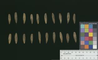 | | 2017 | COLLECTED | 07/07/2017 | Long Hunter State Park approximately 8.5 miles south of Mt. Juliet along Barnett Road, Rutherford County | 36.07491800, -86.51121200 | 162 | High-quality cedar glade. | Wild material | | 1950061 | Ames 33978 |
| 67 | Ames 33979 | JDC/FQ/2017/031/785 | Fraxinus quadrangulata Michx. | Tennessee, United States | NC7 |  | | 2017 | COLLECTED | 07/08/2017 | Along highway 52 approximately 2.30 miles northwest of Celina, Clay County | 36.57174000, -85.53638800 | 190 | Dry, rocky soils. | Wild material | | 1950062 | Ames 33979 |
| 68 | Ames 33982 | JDC/FQ/2017/038/792 | Fraxinus quadrangulata Michx. | Kentucky, United States | NC7 | 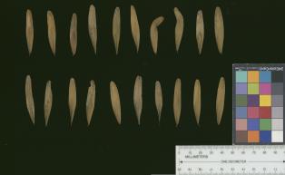 | | 2017 | COLLECTED | 07/10/2017 | Scattered hillside colllections throughout areas approximately 4.5 miles north, northwest of Frankfort, Franklin County | 38.21387700, -84.88886200 | 199 | Mixed wooded deciduous forest, generally steep (45 degree +) slopes and/or hillsides. | Wild material | | 1950065 | Ames 33982 |
| 69 | Ames 33984 | JDC/FQ/2017/040/794 | Fraxinus quadrangulata Michx. | Kentucky, United States | NC7 |  | | 2017 | COLLECTED | 07/11/2017 | Near county line approximately 6.3 miles northwest of Carlisle, Nicholas County | 38.35854300, -83.94605900 | 188 | Scattered hillside, deciduous woods. | Wild material | | 1950067 | Ames 33984 |
| 70 | Ames 33985 | JDC/FQ/2017/041/795 | Fraxinus quadrangulata Michx. | Kentucky, United States | NC7 |  | | 2017 | COLLECTED | 07/12/2017 | Carter Caves State Resort Park near Smoky Valley Lake just 4.46 miles south of Carter, Carter County | 38.36772700, -83.12512200 | 230 | Deciduous woods. | Wild material | | 1950068 | Ames 33985 |
| 71 | Ames 33987 | JDC/FQ/2017/043/797 | Fraxinus quadrangulata Michx. | Ohio, United States | NC7 |  | | 2017 | COLLECTED | 07/12/2017 | Strait Creek Prairie Bluffs Preserve between Peebles and Sinking Spring along highway 41 (Crooked Creek, Strait Creek and Scioto Brush Creek watersheds), Adams and Highland County | 39.00561100, -83.37365400 | 235 | Mixed deciduous woods, generally on top of moist seep, but also on rocky gentle (30-45 degree) slopes. | Wild material | | 1950070 | Ames 33987 |
| 72 | Ames 33988 | JDC/FQ/2017/044/798 | Fraxinus quadrangulata Michx. | Ohio, United States | NC7 |  | | 2017 | COLLECTED | 07/13/2017 | Baker Tract Preserve (Athens Conservancy) due east approximately 5.68 miles of Athens, T5N R13W SE 1/4 Sec. 16, Athens County | 39.32744200, -81.99581300 | 239 | Deciduous woods, rather steep (45 degree) slopes mostly southeast or southwest facing or found on ridge top. | Wild material | | 1950071 | Ames 33988 |
| 73 | Ames 33989 | JDC/FQ/2017/045/799 | Fraxinus quadrangulata Michx. | Ohio, United States | NC7 |  | | 2017 | COLLECTED | 07/14/2017 | Battelle-Darby Creek Metro Park approximately 11.7 miles southwest of Columbus, Franklin County | 39.89846500, -83.21273600 | 282 | High-quality deciduous woods. | Wild material | | 1950072 | Ames 33989 |
| 74 | Ames 33991 | JDC/FQ/2017/047/801 | Fraxinus quadrangulata Michx. | Ohio, United States | NC7 | 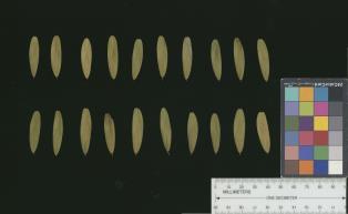 | | 2017 | COLLECTED | 07/15/2017 | Near Seymour Woods State Preserve along Olentangy River watershed approximately 4.7 miles south of Delaware, T4N R19W, Delaware County | 40.24709800, -83.05712000 | 252 | Deciduous woods, mostly found along steep (45-50 degree) slopes adjacent to watershed. | Wild material | | 1950074 | Ames 33991 |
| 75 | NA 86662 | SE-2017-016 | Quercus shumardii Buckley | Georgia, United States | NA | | | 2017 | COLLECTED | 10/14/2017 | Oconee National Forest: Monticello Glades. | 33.25416000, -83.68386000 | 185 | Moist woods. | Wild material | On the original collection notes, this was assigned the field collection number SE-2017-017, but it was corrected to SE-2017-016 later. | 2141807 | NA 86662 |
| 76 | WLP 1179 | NA 83874 | Frangula caroliniana (Walter) A. Gray | Kentucky, United States | NA | | | 2016 | COLLECTED | 09/26/2016 | Floracliff Nature Sanctuary & Trail's End. | 38.01100000, -84.51700000 | 255 | Dense woodland. | | | 1950543 | WLP 1179 |
| 77 | WLP 1436 | NA 83951 | Oxydendrum arboreum (L.) DC. | Kentucky, United States | NA | | | 2016 | COLLECTED | 09/29/2016 | Kentenia State Forest, Pine Mountain, opening in canopy on Route 1679, south side. | 36.92000000, -83.24200000 | 795 | Roadside, opening in canopy. | | | 1951128 | WLP 1436 |
| 78 | WLP 1529 | NA 83963 | Philadelphus hirsutus Nutt. | Kentucky, United States | NA | | | 2016 | COLLECTED | 09/30/2016 | Limestone ridge/outcrop near Lake Cumberland. [GPS coordinates do not appear to be exact. -SBL] | 36.93100000, -84.58200000 | 238 | Limestone ridge/outcrop. | | | 1950300 | WLP 1529 |
| 79 | WLP 1704 | NA 83942 | Rhus glabra L. | Kentucky, United States | NA | | | 2016 | COLLECTED | 09/29/2016 | Kentenia State Forest, Pine Mountain, on Route 1679, south side. | 36.90500000, -83.29100000 | 771 | Roadside. | | | 1953164 | WLP 1704 |
| 80 | WLP 1705 | NA 83948 | Rhododendron maximum L. | Kentucky, United States | NA | | | 2016 | COLLECTED | 09/29/2016 | Kentenia State Forest, Pine Mountain, on Route 1679, north side. | 36.91400000, -83.25900000 | 758 | Roadside. | | | 1950864 | WLP 1705 |
| 81 | WLP 872 | NA 83949 | Clethra acuminata Michx. | Kentucky, United States | NA | | | 2016 | COLLECTED | 09/29/2016 | Kentenia State Forest, Pine Mountain, on Route 1679, south side. | 36.91500000, -83.25900000 | 760 | Roadside. | | | 1951703 | WLP 872 |
| 82 | Ames 33288 | APS/GD/2016/009/244 | Gymnocladus dioicus (L.) K. Koch | Michigan, United States | NC7 |  | | 2016 | COLLECTED | 04/05/2016 | Ottawa County: T7N R13W SW 1/4 SW 1/4 NE 1/4 Sec. 32; T7N R13W NE 1/4 NE 1/4 SW 1/4 Sec. 29; and T7N R14W NW 1/4 NW 1/4 Sec. 10 along Grand River both north (approximately 2.87 miles) and east (approximately 3.84 miles) of Allendale. | 43.00148000, -85.91236400 | 184 | Floodplain. | Wild material | | 1940345 | Ames 33288 |
| 83 | DDIO 266 | JDC/DV/2014/050/552 | Diospyros virginiana L. | Missouri, United States | DAV | | | 2015 | COLLECTED | 09/19/2014 | PIKE COUNTY: Buffalo Knob along MO highway WW. | 39.27421400, -91.04618000 | 270 | Dry woods, rocky south-facing steep slope. Growing in association with Quercus muehlenbergii, Fraxinus americana, Fraxinus quadrangulata, Juniperus virginiana, Ulmus sp., Cercis canadensis, and Lonicera maackia. | Wild material | | 1927163 | DDIO 266 |
| 84 | Ames 32923 | JDC/FQ/2015/038/694 | Fraxinus quadrangulata Michx. | Oklahoma, United States | NC7 |  | | 2015 | COLLECTED | 05/22/2015 | T19 R12E N 1/4 Sec. 18 and extreme SE 1/4 Sec. 7 Tulsa County. Chandler Park. | 36.13235400, -96.07376000 | 264 | Rocky, very shallow soils on north and northwest-facing slopes. Growing in association with Fraxinus americana, Cotinus obovatus, Celtis sp., Cornus sp., Ulmus sp., Cercis canadensis, Juniperus virginiana, Quercus muehlenbergii, Smilax sp., Toxicodendron radicans, Quercus texana, and Quercus stellata (chlorotic). | Wild material | | 1926265 | Ames 32923 |
| 85 | WLP 1096 | JDC/CO/2015/025/681 | Cotinus obovatus Raf. | Missouri, United States | NA |  | | 2015 | COLLECTED | 05/19/2015 | T24N R16W NW 1/4 Sec. 4, SW 1/4 SW 1/4 Sec. 17, and SW 1/4 Sec. 9 Ozark County. Mark Twain National Forest Caney Picnic Area (County Road 935) | 36.79873000, -92.71575700 | 407 | Rocky, very shallow soils. Growing in association with Quercus muehlenbergii, Diospyros virginiana, Cercis canadensis, Viburnum rufidulum, Delphinium carolinianum, Penstemon cobea, Rudbeckia sp., Fraxinus americana, Fraxinus quadrangulata (few), Cornus florida, Oenothera macrocarpa, Juniperus virginiana, Tradescantia sp., and Silphium terebinthinaceum. | Wild material | | 1926254 | WLP 1096 |
| 86 | WLP 1098 | JDC/CO/2015/030/686 | Cotinus obovatus Raf. | Arkansas, United States | NA |  | | 2015 | COLLECTED | 05/20/2015 | T18N R15W NW 1/4 Sec. 15 and SE 1/4 Sec. 10 Marion County. Hall Mountain area along County Road 6074. | 36.20574400, -92.56150900 | 239 | Rocky, very shallow soils. Growing in association with Quercus muehlenbergii, Juniperus virginiana, Acer saccharum, Cercis canadensis, Lindera benzoin, Diospyros virginiana, Silphium terebinthinaceum, Baptisia sp., Rudbeckia sp., and Rhus glabra. | Wild material | | 1926260 | WLP 1098 |
| 87 | WLP 1099 | JDC/CO/2015/031/687 | Cotinus obovatus Raf. | Arkansas, United States | NA |  | | 2015 | COLLECTED | 05/20/2015 | T16N R10W SW 1/4 Sec. 35 and SE 1/4 Sec. 34 and also T15N R10W S 1/2 Sec. 3 Izard County. Brandenburg Mountain area, along highway 9 between Allison and Melbourne. | 35.99358500, -92.02874700 | 170 | Rocky, very shallow soils. Growing on both north, southeast, and west-facing slopes in association with Quercus muehlenbergii, Quercus stellata, Juniperus virginiana, Cercis canadensis, Delphinium carolinianum, Echinacea sp., Fraxinus americana, and Yucca sp. | Wild material | | 1926261 | WLP 1099 |
| 88 | WLP 1101 | JDC/CO/2015/036/692 | Cotinus obovatus Raf. | Oklahoma, United States | NA |  | | 2015 | COLLECTED | 05/21/2015 | T16N R20E W 1/2 Sec. 18 Wagoner and Cherokee Counties. Fort Gibson Lake Dam. | 35.86228100, -95.22575600 | 170 | Growing on shallow, rocky soils in association with Carya illinoinensis, Quercus muehlenbergii, Cornus sp., Cercis canadensis, Fraxinus americana, Platanus occidentalis, Ulmus sp., Diospyros virginiana, Sapindus saponaria var. drummondii, Lonicera sempervirens, Smilax sp., Toxicodendron radicans, and Robinia pseudoacacia. | Wild material | | 1926263 | WLP 1101 |
| 89 | WLP 1102 | JDC/CO/2015/037/693 | Cotinus obovatus Raf. | Oklahoma, United States | NA |  | | 2015 | COLLECTED | 05/22/2015 | T19 R12E N 1/4 Sec. 18 and extreme SE 1/4 Sec. 7 Tulsa County. Chandler Park. | 36.13366000, -96.06623100 | 264 | Rocky, very shallow soils on north and northwest-facing slopes. Growing in association with Fraxinus americana, Fraxinus quadrangulata, Celtis sp., Cornus sp., Ulmus sp., Cercis canadensis, Juniperus virginiana, Quercus muehlenbergii, Smilax sp., Toxicodendron radicans, Quercus texana, and Quercus stellata (chlorotic). | Wild material | | 1926264 | WLP 1102 |
| 90 | Ames 32891 | APS/GD/2015/010/192 | Gymnocladus dioicus (L.) K. Koch | Oklahoma, United States | NC7 |  | | 2015 | COLLECTED | 03/12/2015 | Nowata County: T25N R16E NW 1/4 NE 1/4 Sec. 3. Oologah Wildlife Management Area approximately 3 miles east of Nowata. | 36.68401000, -95.58207800 | 208 | Transition zone between higher elevations and bottomlands. | Wild material | | 1925357 | Ames 32891 |
| 91 | Ames 32893 | APS/GD/2015/016/198 | Gymnocladus dioicus (L.) K. Koch | Oklahoma, United States | NC7 |  | | 2015 | COLLECTED | 03/14/2015 | Creek County: West Fork Sandy Creek watershed and small tributaries. T14N R9E SW 1/4 SE 1/4 Sec. 21. Private property approximately 11 miles south of Bristow. | 35.66820200, -96.35882500 | 216 | Floodplain. | Wild material | | 1925359 | Ames 32893 |
| 92 | Ames 32901 | APS/GD/2015/029/211 | Gymnocladus dioicus (L.) K. Koch | Oklahoma, United States | NC7 |  | | 2015 | COLLECTED | 03/18/2015 | Major County: T20N R15W NE 1/4 Sec. 36. Canton Wildlife Management Area approxiamtely 9.5 miles east of Seiling. | 36.16760000, -98.74597300 | 503 | Transition zone between higher elevations and bottomlands. | Wild material | This collection represents genetics from the far western range of Kentucky coffeetree. Numerous large specimens were noted throughout this area and specimens 674-4 and 674-5 were collected in the vicinity of the current (2019) Oklahoma State Champion Gymnocladus dioicus which was nominated by Carstens and Schmitz in 2015. The state champion specimen (likely a male) was officially measured on 21 April 2015 by Riley Coy (Oklahoma Forestry Services): 100.5" circumference, 90' in height, 51.5' crown spread totalling 203 points. | 1925367 | Ames 32901 |
| 93 | Ames 32903 | APS/GD/2015/031/213 | Gymnocladus dioicus (L.) K. Koch | Oklahoma, United States | NC7 |  | | 2015 | COLLECTED | 03/19/2015 | Osage County: Arkansas River watershed area known as Souters Bend, T21N R7E. Keystone Wildlife Management Area (John Lowery Unit) approximatley 3 miles west of Cleveland. | 36.30185300, -96.53051000 | 222 | Floodplain, but one specimen sampled was located on dry, rocky (large boulders) bluff. | Wild material | | 1925369 | Ames 32903 |
| 94 | Ames 32904 | APS/GD/2015/032/214 | Gymnocladus dioicus (L.) K. Koch | Oklahoma, United States | NC7 |  | | 2015 | COLLECTED | 03/19/2015 | Osage County: Sand Creek watershed area, T27N R8E SE 1/4 NW 1/4 Sec. 10. Tallgrass Prairie Preserve approximately 13 miles northwest of Pawhuska. | 36.83425300, -96.43091600 | 307 | Dry, rocky outcroppings and floodplain. | Wild material | | 1925370 | Ames 32904 |
| 95 | NA 83061 | ZARKS-005 | Gymnocladus dioicus (L.) K. Koch | Arkansas, United States | NA | | | 2015 | COLLECTED | 10/02/2014 | Frog Valley (private property). West bank of North Fork of Saline River. | 34.76276000, -92.71386000 | 133 | Alluvial low floodplain, in sandy clay soil. Slope: 0 degrees. Elevation: 435 feet. | Wild material | | 1950627 | NA 83061 |
| 96 | NA 83062 | NA 83062 | Taxodium distichum (L.) Rich. | Arkansas, United States | NA | | | 2015 | COLLECTED | 10/02/2014 | Frog Valley (private property). Banks of North Fork of Saline River. | 34.76443000, -92.71338000 | 135 | Alluvial low floodplain, in gravel bank. | | | 1951432 | NA 83062 |
| 97 | NA 83063 | NA 83063 | Hamamelis vernalis Sarg. | Arkansas, United States | NA | | | 2015 | COLLECTED | 10/02/2014 | Frog Valley (private property). Gravel bar along North Fork of Saline River. | 34.76543000, -92.71353000 | 134 | Alluvial low floodplain; gravel bar. | | | 1950887 | NA 83063 |
| 98 | NA 82053 | JDC/QM/2014/079/581 | Quercus montana Willd. | Mississippi, United States | NA | | | 2014 | COLLECTED | 09/22/2014 | Mississippi: Tishomingo County; Near J.P. Coleman State Park off County Road 989. | 34.97300100, -88.21763300 | 166 | Pine-oak woods. Growing in association with Liriodendron tulipifera, Pinus sp., Quercus alba, Quercus stellata, Carya sp., Rhus copallinum, Cornus florida, and Cercis canadensis. | Wild material | Optimum timing for harvest. Acorns just starting to drop. Petioles yellow. | 1922354 | NA 82053 |
| 99 | Ames 32018 | APS/GD/2013/032/117 | Gymnocladus dioicus (L.) K. Koch | Missouri, United States | NC7 |  | | 2013 | COLLECTED | 04/09/2013 | Poosey Conservation Area, Livingston County. | 39.94995200, -93.71471700 | 267 | Floodplain. | Wild material | A total of four areas containing Gymnocladus dioicus were noted throughout Poosey Conservation Area. Each area was represented by approximately 2-6 specimens. Specimens ranged between 14-22.5 inches d.b.h. and approximately 90-110 feet in height. Pod production during the 2012 growing season was minimal/below average. Samples 473-1 and 473-2 were very close together (approximately 10 feet apart) and samples 473-3 and 473-4 were also very close together (approximately 48 feet apart). Samples this close together may potentially represent material from a single clone due to the clonal suckering habit of Gymnocladus dioicus. | 1908307 | Ames 32018 |
| 100 | Ames 31986 | APS/GD/2013/010/095 | Gymnocladus dioicus (L.) K. Koch | Kansas, United States | NC7 |  | | 2013 | COLLECTED | 02/20/2013 | South Gypsum Creek Maxwell Wildlife Refuge, north of Canton, boundary line between Sections 21 and 22, T18S R1W, McPherson County. | 38.46916733, -97.42786767 | 430 | Dry floodplain. | Wild material | | 1907539 | Ames 31986 |
| 101 | Ames 31987 | APS/GD/2013/011/096 | Gymnocladus dioicus (L.) K. Koch | Kansas, United States | NC7 |  | | 2013 | COLLECTED | 02/20/2013 | Camp Wood, near Cottonwood River, south of Elmdale, NW 1/4 of Section 3, T20S R7E, Chase County. | 38.34698100, -96.65080500 | 377 | Samples obtained from both upland, rocky and floodplain habitat. | Wild material | | 1907540 | Ames 31987 |
| 102 | Ames 31519 | JDC/FQ/2012/028/421 | Fraxinus quadrangulata Michx. | Iowa, United States | NC7 |  | | 2012 | COLLECTED | 07/20/2012 | Along Twin Rivers Drive, NE 1/4 of Section 34, T65N, R5W, Keokuk Quad, just southwest of Keokuk, Des Moines County. | 40.38649700, -91.42619300 | 182 | Dry woods. Steep south and southwest-facing slopes. | Wild material | | 1903746 | Ames 31519 |
| 103 | Ames 31526 | JDC/FQ/2012/035/428 | Fraxinus quadrangulata Michx. | Indiana, United States | NC7 |  | | 2012 | COLLECTED | 07/23/2012 | Along Trailhead #1, Charlestown State Park, near Charlestown, Clark County. | 38.44706000, -85.64315400 | 180 | Open grown specimens in glade, and also localized population amongst dense canopy forest on southeast-facing slope. Very shallow soils. | Wild material | | 1903753 | Ames 31526 |
| 104 | Ames 31528 | JDC/FQ/2012/037/430 | Fraxinus quadrangulata Michx. | Indiana, United States | NC7 |  | | 2012 | COLLECTED | 07/24/2012 | Along Highway 52, N 1/2 of Section 19, T9N, R2W, Brookville Quad, approximately 0.5 to 1 mile west of Brookville, Franklin County. | 39.43205200, -85.02163400 | 209 | Roadside collection. South and southeast-facing slopes. | Wild material | | 1903755 | Ames 31528 |
| 105 | Ames 31529 | JDC/FQ/2012/038/431 | Fraxinus quadrangulata Michx. | Indiana, United States | NC7 |  | | 2012 | COLLECTED | 07/24/2012 | Lick Creek Summit Nature Preserve, NW 1/4 of Section 23, T13N, R2W, Richmond Quad, near Richmond, Wayne County. | 39.78453000, -84.95276400 | 267 | Dry woods. Bluffs. Shallow soils. | Wild material | | 1903756 | Ames 31529 |
| 106 | W6 44359 | CA360-104 | Festuca californica Vasey | California, United States | W6 |  | | 2012 | | | | | | | Wild material | | 1901158 | W6 44359 |
| 107 | NA 80067 | NA 80067 | Cladrastis kentukea (Dum. Cours.) Rudd | Kentucky, United States | NA | | | 2011 | COLLECTED | 10/02/2001 | Palisades (a locally used term to describe the sheer cliffs along the Kentucky River); along the west side of Kentucky Route 27 just north of Hall, Kentucky. | 37.79288000, -84.60705000 | 300 | Growing on the thin soils of the sheer limestone cliffs just below the top of the cliffs. | | | 1953441 | NA 80067 |
| 108 | Ames 30599 | JDC/FA/2010/031/301 | Fraxinus americana L. | Kansas, United States | NC7 |  | | 2010 | COLLECTED | 09/13/2010 | Near Big Sugar Creek watershed, east of Centerville, Linn County. | 38.21145000, -94.93801000 | 294 | Upland areas. Variable aspects. | Wild material | | 1848894 | Ames 30599 |
| 109 | Ames 30604 | JDC/FQ/2010/037/307 | Fraxinus quadrangulata Michx. | Missouri, United States | NC7 |  | | 2010 | COLLECTED | 09/14/2010 | Fiddlers Ford Conservation Area, Dade County. | 37.38418300, -93.79576000 | 294 | Rock outcropping. South facing slope (40%). | Wild material | | 1848899 | Ames 30604 |
| 110 | OPGC 3449 | PZ10-201 | Phlox bifida L. C. Beck | Kentucky, United States | OPGC |  | | 2010 | COLLECTED | 08/26/2010 | Jessamine Co. At NW corner of intersection of Kentucky 27 and Kentucky River | 37.46096000, -84.36533000 | 219 | Dolomite cliffs; Juniperus virginiana, Cercis canadensis | Wild material | Mat-forming evergreen subshrub; flowers pale lavender, with or without deep-purple striae; leaves lanceolate-subulate, glabrous | 1897765 | OPGC 3449 |
| 111 | OPGC 3442 | PZ10-193 | Phlox glaberrima L. | Ohio, United States | OPGC |  | | 2010 | COLLECTED | 07/08/2010 | Adams Co. W side of West Fork Road, Immediately S of intersection with Abner Hollow Road; | 38.43224000, -83.25212000 | 243 | Roadside disturbed area under power line right of way; Phlox paniculata, Coreopsis major, Asclepias verticillata, Juniperus virginiana, Cercis canadensis | Wild material | Erect, sender perennial in flower, sterile stems decumbent and evergreen; flowers bright magenta-pink; leaves glabrous | 1897758 | OPGC 3442 |
| 112 | Ames 30392 | JDC/RT/2009/099/249 | Rhus typhina L. | Ohio, United States | NC7 |  | | 2009 | COLLECTED | 10/16/2009 | Deans State Forest, near Bartles, T3N R17W NE 1/4 of NE 1/4 of Sec. 27, Pedro Quad, Lawerence County | 38.70027778, -82.63333333 | 298 | High elevation. Underground seep present. | Wild material | | 1823944 | Ames 30392 |
| 113 | WLP 1219 | JDC/HA/2009/096/246 | Hydrangea arborescens L. | Ohio, United States | NA | | | 2009 | COLLECTED | 10/16/2009 | Near Five Forks, NE 1/4 of NE 1/4 of Section 29, T4N, R17W, Kitts Hill Quad, Lawerence County. | 38.62305556, -82.55638889 | 262 | Associated with Acer rubrum, Carya, Cercis canadensis, and Liriodendron tulipifera. | Wild material | | 1823927 | WLP 1219 |
| 114 | WLP 1423 | JDC/OA/2009/098/248 | Oxydendrum arboreum (L.) DC. | Ohio, United States | NA | | | 2009 | COLLECTED | 10/16/2009 | Ohio: Lawrence County; Deans State Forest, near Bartles, SE 1/4 of NE 1/4 of Section 27, T3N, R17W, Pedro Quad. | 38.69833333, -82.63222222 | 301 | High elevation. Steep (60%) slope, east-facing. Underground seep present. Associated with Acer rubrum, Cercis canadensis, Corylus americana, Juglans nigra, Quercus rubra, Rhus typhina, and Sassfras albidum. | Wild material | | 1823936 | WLP 1423 |
| 115 | WLP 1951 | JDC/VR/2009/110/260 | Viburnum rufidulum Raf. | Ohio, United States | NA | | | 2009 | COLLECTED | 10/18/2009 | Along Ohio County Highway 106 (Suck Run Road), just south of Neel, Decatur Quad, Brown County. | 39.00000000, -84.00000000 | 224 | 45% slope, southeast and east facing. Associated with Acer saccharum, Celtis occidentalis, Cercis canadensis, Cornus florida, Fraxinus quadrangulata, Quercus, Staphylea trifolia, Viburnum molle, and V. prunifolium. | Wild material | | 1823957 | WLP 1951 |
| 116 | Ames 30090 | 01A | Fraxinus pennsylvanica Marshall | Kansas, United States | NC7 |  | | 2009 | COLLECTED | 09/14/2009 | Along Cedar Creek, 4.5 miles south of Cedar Point, Chase County. | 38.19250000, -96.81194444 | | Along a stream. | Wild material | | 1813253 | Ames 30090 |
| 117 | Ames 29639 | JDC/FA/2008/060/130 | Fraxinus americana L. | Illinois, United States | NC7 |  | | 2008 | COLLECTED | 10/12/2008 | Along 2150 North Road, east of Irvington, NE 1/4 of SW 1/4 of Section 15, T1S, R1E, Walnut Hill Quad, Jefferson County. | 38.43833333, -89.07833333 | 161 | | Wild material | | 1788194 | Ames 29639 |
| 118 | Ames 29647 | JDC/FP/2008/077/147 | Fraxinus pennsylvanica Marshall | Illinois, United States | NC7 |  | | 2008 | COLLECTED | 10/14/2008 | Near Duck Creek, near Rice Lake Fish and Wildlife Refuge, NW 1/4 of NE 1/4 of Section 5, T5N, R8W, Duck Island Quad, Fulton County. | 40.45583333, -89.96111111 | 137 | | Uncertain improvement status | | 1788202 | Ames 29647 |
| 119 | WLP 1369 | JDC/LB/2008/044/114 | Lindera benzoin (L.) Blume | Missouri, United States | NA |  | | 2008 | COLLECTED | 10/09/2008 | Missouri: Bollinger County; Amidon Memorial Conservation Area, near Stannett Creek, south edge of NE 1/4 of SE 1/4 of Section 10. | 37.56027778, -90.13972222 | 232 | Common in understory/fairly shaded areas. Associated with Acer saccharum, Carpinus caroliniana, Cercis canadensis, Fraxinus americana, Juglans nigra, Quercus muhlenbergii, Staphylea trifolia, Ulmus, and Viburnum prunifolium. | Wild material | Some original plants with yellow fall color. | 1788215 | WLP 1369 |
| 120 | NA 78025 | AL #34 | Hydrangea arborescens L. | Alabama, United States | NA | | | 2008 | COLLECTED | 09/17/2008 | Kathy Stiles Freeland Preserve. Nature Conservancy property. | | | Right along edge of creek, in part in creek. | Wild material | | 1913891 | NA 78025 |
| 121 | WLP 2307 | LBJWC-MLE-036 | Ostrya virginiana (Mill.) K. Koch | Texas, United States | NA | | | 2008 | COLLECTED | 09/28/2006 | Approximately 7 miles south of Alto, Texas on 294. | 31.63803000, -95.21316000 | 94 | Mixed hardwood and pine/forest roadside; rolling hills. Reddish tan colored, sandy soil over sandstone. | Wild material | | 1781863 | WLP 2307 |
| 122 | Ames 27325 | 32 | Euonymus atropurpureus Jacq. | Iowa, United States | NC7 |  | | 2003 | COLLECTED | 09/23/2003 | Lindsay Wilderness Area, Bonaparte, SE corner of NE 1/4, Section 9, T68N, R8W, Bonaparte Quad, Van Buren County. | 40.70416667, -91.77611111 | 189 | Ditch near powerline cut. Sunny. ~25% slope with a mostly western aspect | Wild material | Medium sized shrub or small tree. | 1649671 | Ames 27325 |
| 123 | Ames 27329 | 34 | Ptelea trifoliata L. | Iowa, United States | NC7 |  | | 2003 | COLLECTED | 09/24/2003 | Bluff Park, Keokuk, South of Park Street at G, T65N R5W, Section 35, Keokuk Quad. | 40.38861111, -91.40277778 | 194 | Bluff edge along Mississippi River. Sunny. 25% slope with a southern aspect. Soil well to good drainage. | Wild material | | 1649675 | Ames 27329 |
| 124 | Ames 27331 | 26 | Staphylea trifolia L. | Iowa, United States | NC7 |  | | 2003 | COLLECTED | 09/22/2003 | North of Ely Ford, Lacey-Keosauqua State Park near Keosauqua, T68N R10W SE corner of SE 1/4 of NE 1/4 of Sec. 3, Van Buren County | 40.71861111, -91.98861111 | 177 | Slope down to Des Moines River. Mostly shaded. 20% slope with a southeastern aspect | Wild material | Medium sized shrubs. Pods to 7 cm long. | 1649677 | Ames 27331 |
| 125 | Ames 27962 | Quercus Wilderness Area | Amelanchier arborea (F. Michx.) Fernald | Iowa, United States | NC7 |  | | 2003 | COLLECTED | 05/26/2003 | Quercus Wilderness Area located 6.75 miles south, southwest of Oskaloosa, T74N R16W SE ¼ NE ¼ of Sec. 23. | 41.19888889, -92.66111111 | 244 | Mature woods on very sandy soils. Typically restricted to east, west or south facing slopes at either summits or mid-slopes. | Wild material | The native range of Amelanchier arborea is concentrated in the eastern half of the U.S. (Little, 1977). This accession represents a collection of A. arborea germplasm from the western edge of the species native range, specifically the southern portion of Iowa. As of 2025, the top ten largest specimens in the state of Iowa are located at Quercus Wilderness where this accession was collected. Iowa’s largest specimen of A. arborea specimen at Quercus Wilderness was measured at 14.17" DBH, 51.83’ in height, and 27.00’ average crown spread for a total of 102.955 points (Rouw, M., personal communication, 12 December 2023). Fall color (orange-red) tends to peak in the middle of September (Iowa) with peak fruiting occurring in early May. Bark smooth, grey. | 1700483 | Ames 27962 |
| 126 | DLEG 900385 | DLEG 900385 | Senegalia roemeriana (Scheele) Britton & Rose | Texas, United States | | | Historic | 1990 | COLLECTED | 07/06/1990 | Pecos Co., Hwy 285, 14.3 mi. N of jct. U.S. Hwy 90 at Sanderson. | | | Rocky limestone hills with Cercis canadensis var. mexicana, Eysenhardtia orthocarpa, Ungnadia speciosa, Rhus virens, Prosopis glandulosa var. glandulosa, Quercus sp., Dasylirion leiophyllum. | Wild material | Catclaw-like prickles; rounded leaflets; white flowers in rounded heads, flattened pods. M. Johnson 90-051. | 1528549 | DLEG 900385 |