| 0 | DDIO 53 | 880392 | Diospyros lotus L. | Punjab, Pakistan | DAV | 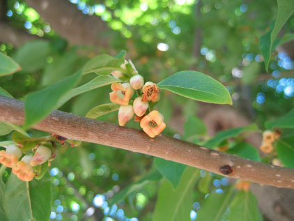 | | 1988 | COLLECTED | 10/12/1988 | Collected in Murree, Rawalpindi, 59km northeast of Islamabad, in town from a private citizen's yard. | 33.90000000, 73.40000000 | 2092 | Mountains. Full sun exposure, terraced slope. Loam soil, well-drained. Associated vegatation: Pyrus pashia, Cornus macrophylla, Aesculus, Cotoneaster, Ulmus. | Wild material | | 1001700 | DDIO 53 |
| 1 | NA 88931 | 24Flam27 | Rhododendron flammeum (Michx.) Sarg. | Georgia, United States | NA | | | 2025 | COLLECTED | 09/10/2024 | DeKalb County: Stone Mountain: Stone Mountain Park along Evergreen Trail by resort, growing within 40 feet of Venable Lake. GPS coordinates a general locality for population and each seed lot for 24Flam27-30 was collected progressively further west). | 33.79769000, -84.13420000 | 291 | Dry, somewhat shady forest adjacent to lake, some plants hanging over edge. Primarily close to the water on flat ground, though some on slope. Growing in half shade. Slope: Flat to 30 degrees. Aspect: North. | Wild material | Note: Seeds from three different lots collected at the same spot were bulked together in this accession; the lowest field collection number (24Flam27) has been chosen as the primary for this record. | 2172814 | NA 88931 |
| 2 | WLP 3140 | TJK2023AL-004 | Viburnum acerifolium L. | Alabama, United States | NA | | | 2023 | COLLECTED | 08/15/2023 | Haines Island Park; overlooks the Alabama River. | 31.72057000, -87.46543000 | 86 | Beautiful Pine-Oak forest sits atop the Buhrstone Questa, an escarpment that rises over 350 feet. Southern Red Hills Region. Slope: 10%. Aspect: North. Elevation recorded as 281 feet. | Wild material | WLPGR contract collection. | 2158472 | WLP 3140 |
| 3 | WLP 3138 | TJK2023AL-002 | Hamamelis virginiana L. | Alabama, United States | NA | | | 2023 | COLLECTED | 08/15/2023 | Haines Island Park; overlooks the Alabama River. | 31.72074000, -87.46362000 | 94 | Beautiful Pine-Oak forest sits atop the Buhrstone Questa, an escarpment that rises over 350 feet. Southern Red Hills Region. Slope: 12%. Aspect: West. Elevation recorded as 308 feet. | Wild material | WLPGR contract collection. | 2158470 | WLP 3138 |
| 4 | NA 88549 | RJLSEUS2022-022 | Rhododendron minus Michx. var. minus | Georgia, United States | NA | | | 2023 | COLLECTED | 12/10/2022 | East side of Georgia State Hwy. 39, on the south side of Kolomoki Creek approximately 11 kilometers south of Fort Gaines, Georgia. Common on this site, but otherwise infrequent. This species is near the southernmost end of its natural range. | 31.52053400, -85.02351600 | 53 | Plants are growing in part-shade to shade of deciduous upland, dry, deciduous woodlands on steep slopes 10-15 meters above Kolomoki Creek.
Soils: The underlying geology of this area is of Paleocene origin and characterized as Tuscahoma Sand. As mapped this formation includes lower Eocene Bashi Marl Member of the Hatchetigbee Formation. This formation consists of light-gray to light-olive-gray laminated and thin-bedded carbonaceous silt and clay interbedded with fine sand; thin lignite beds occur locally. Lower part of the formation includes beds of fossiliferous, glauconitic fine quartz sand containing spheroidal sandstone concretions, gravel and clay pebbles.
Source: USGS Georgia Geologic Map Data (https://mrdata.usgs.gov/geology/state/sgmc-unit.php?unit=GANu%3B1)
The primary soil types in the collection area are classified as Ailey-Cowarts Complex Series soils (8 to 25 percent slopes). The Ailey Series consists of well drained or somewhat excessively drained soils formed by fluviomarine and marine deposits. These soils are found marine terraces and low hills of the upper coastal plain and sandhills; they are strongly acidic. The Cowarts Series consists of very deep, moderately well and well drained soils on ridge tops and side slopes on uplands of the Coastal Plain Major Land Resource Area. They formed in loamy marine sediments. Slopes range from 1 to 60 percent.
Source: NRCS Web Soil Survey (https://websoilsurvey.sc.egov.usda.gov/App/WebSoilSurvey.aspx) | Wild material | | 2140776 | NA 88549 |
| 5 | NA 88550 | RJLSEUS2022-023 | Kalmia latifolia L. | Georgia, United States | NA | | | 2023 | COLLECTED | 12/10/2022 | East side of Georgia State Hwy. 39, on the south side of Kolomoki Creek approximately 11 kilometers south of Fort Gaines, Georgia. Common on this site, but otherwise infrequent. This species is near the southernmost end of its natural range. | 31.52053400, -85.02351600 | 53 | Plants are growing in part-shade to shade of deciduous upland, dry, deciduous woodlands on steep slopes 10-15 meters above Kolomoki Creek.
Soils: The underlying geology of this area is of Paleocene origin and characterized as Tuscahoma Sand. As mapped this formation includes lower Eocene Bashi Marl Member of the Hatchetigbee Formation. This formation consists of light-gray to light-olive-gray laminated and thin-bedded carbonaceous silt and clay interbedded with fine sand; thin lignite beds occur locally. Lower part of the formation includes beds of fossiliferous, glauconitic fine quartz sand containing spheroidal sandstone concretions, gravel and clay pebbles.
Source: USGS Georgia Geologic Map Data (https://mrdata.usgs.gov/geology/state/sgmc-unit.php?unit=GANu%3B1)
The primary soil types in the collection area are classified as Ailey-Cowarts Complex Series soils (8 to 25 percent slopes). The Ailey Series consists of well drained or somewhat excessively drained soils formed by fluviomarine and marine deposits. These soils are found marine terraces and low hills of the upper coastal plain and sandhills; they are strongly acidic. The Cowarts Series consists of very deep, moderately well and well drained soils on ridge tops and side slopes on uplands of the Coastal Plain Major Land Resource Area. They formed in loamy marine sediments. Slopes range from 1 to 60 percent.
Source: NRCS Web Soil Survey (https://websoilsurvey.sc.egov.usda.gov/App/WebSoilSurvey.aspx) | Wild material | | 2140777 | NA 88550 |