| 0 | NA 88578 | 2024RJLFL-004 | Ilex vomitoria Aiton | Florida, United States | NA | | | 2024 | COLLECTED | 11/12/2024 | Collected along Florida National Scenic Trail/Eglin Air Force Base unnamed road. | 30.44526100, -86.86094700 | 4 | Mixed evergreen and deciduous forests in part shade to full sun. Slope: 5 to 10 percent. Aspect: Various. The underlying geology of this area is characterized as Citronelle Formation of the Pliocene period. The Citronelle Formation is widespread in the Gulf Coastal Plain. The type section for the Citronelle Formation, named by Matson (1916), is near Citronelle, Alabama. The Citronelle Formation grades laterally, through a broad facies transition, into the Miccosukee Formation of the eastern Florida panhandle. Coe (1979) investigated the Citronelle Formation in portions of the western Florida panhandle. The Citronelle Formation is a siliciclastic, deltaic deposit that is lithologically similar to, and time equivalent with, the Cypresshead Formation and, at least in part, the Long Key Formation (Cunningham et al., 1998) of the peninsula. In the western panhandle, some of the sediments mapped as Citronelle Formation may be reworked Citronelle. The lithologies are the same and there are few fossils present to document a possible younger age. The Citronelle Formation consists of gray to orange, often mottled, unconsolidated to poorly consolidated, very fine to very coarse, poorly sorted, clean to clayey sands. It contains significant amounts of clay, silt and gravel which may occur as beds and lenses and may vary considerably over short distances. Limonite nodules and limonite-cemented beds are common. Marine fossils are rare but fossil pollen, plant remains and occasional vertebrates are found. Much of the Citronelle Formation is highly permeable. It forms the Sand and Gravel Aquifer of the surficial aquifer system contain organics. The dominant fossils in the freshwater carbonates are mollusks. (Source: USGS Florida Geologic Map Data). The soils of this are characterized as Lakeland Series Sand, 5 to 12 percent slopes. The Lakeland series consists of very deep, excessively drained, rapid to very rapidly permeable soils on uplands. They formed in thick beds of eolian or marine and/or fluvio-marine sands in the Southern Coastal Plain MLRA (133A), the Carolina and Georgia Sandhills (MLRA 137), the Eastern Gulf Coast Flatwoods (MLRA 152A) and the Atlantic Coast Flatwoods (MLRA 153A). Slopes are dominantly from 0 to 12 percent but can range to 85 percent in dissected areas. Thickness of the sand exceeds 200 cm. Silt plus clay in the 25 to 100 cm control section ranges from 5 to 10 percent. Reaction ranges from very strongly acid to moderately acid throughout. (Source: California Soil Resource Lab/NRCS Official Soil Series Descriptions). | Wild material | | 2169915 | NA 88578 |
| 1 | NA 87836 | TRX241117-01VA | Ilex vomitoria Aiton | Virginia, United States | NA | | | 2024 | COLLECTED | 11/17/2024 | Eastern Shore of Virginia National Wildlife Refuge. | 37.13092000, -75.96253000 | 6 | | Wild material | | 2169889 | NA 87836 |
| 2 | NA 87848 | TRX241119-04GA | Ilex vomitoria Aiton | Georgia, United States | NA | | | 2024 | COLLECTED | 11/19/2024 | Jekyll Island. | 31.11344000, -81.40673000 | 4 | The first vegetation occuring at the top of the beach, where high tide is actively eroding. | Wild material | | 2169901 | NA 87848 |
| 3 | NA 88478 | TXWL2024-028 | Ilex vomitoria Aiton | Texas, United States | NA | | | 2024 | COLLECTED | 11/12/2024 | Big Thicket National Preserve: Turkey Creek Unit.: Pitcher Plant Trail. | 30.58602000, -94.34154000 | | Bog/wetland. | Wild material | | 2169863 | NA 88478 |
| 4 | NA 88813 | TXWL2023-020 | Ilex vomitoria Aiton | Texas, United States | NA | | | 2023 | COLLECTED | 12/06/2023 | Private property (Bayou Bleu Farm). | 31.66376880, -94.01070880 | | Road edge of wooded road; mixed pine-hardwood stand. | Wild material | | 2165617 | NA 88813 |
| 5 | NA 87267 | (female selection) | Ilex vomitoria Sol. ex Aiton f. pendula Foret & Solymosy | Texas, United States | NA | | | 2022 | COLLECTED | 01/27/2020 | Plants growing on the north side of the unpaved Private Road 6061, approximately 0.4 kilometers east of Texas State Hwy 87. | 31.16207000, -93.72862000 | 132 | Growing in almost full sun on a south-facing roadside slope in very dry upland conditions. Soils are deep, somewhat excessively well-drained, and typically strongly acidic. Slope: 8 percent. Aspect: South. The underlying geology of this area is of Oligocene origin and characterized as Catahoula Formation. This formation is extensive and deep in Texas, up to 185 meters thick. In the area of the collection the Catahoula Formation is primarily mudstone and sand. The upper 90-150 meters is mudstone that is tuffaceous, and sandy; also, occasionally, with some bentonitic clay. The primary soil types in the collection area are classified as Letney-Tehran soils. These soils consist of deep, somewhat excessively drained, moderately rapidly permeable soils on uplands. They were formed in thick loamy and sandy sediments on the Western Coastal Plain. The Letney-Tehran soils are on gently sloping to moderately steep uplands with slopes ranging from 1 to 20 percent. They are typically strongly acidic. | Wild material | Full name as recorded at U.S. National Arboretum: Ilex vomitoria forma pendula (female selection). Six plants of a selection of weeping yaupon holly sent from Shangri La Botanical Gardens & Nature Center (Rick Lewandowski facilitated the distribution in retirement). It is evidently from a selection discovered growing in Newton County, Texas, presumably from the wild. A date of 11/25/2020 is on the plant's tag from the source, but it is unknown if this is a propagation date or an accession date. Form received: rooted cutting. | 2158071 | NA 87267 |
| 6 | NA 86881 | ASA-009A | Ilex vomitoria Aiton | Virginia, United States | NA | | | 2021 | COLLECTED | 01/13/2020 | Virginia Beach: First Landing State Park. Collected in the park campground, near the location of VIRG-015. One plant at campsite #166, the other near site #73 | 36.91886900, -76.05188900 | 2 | 15 deg slope; SE-facing; sand. Dunes with live oaks | Wild material | | 2116470 | NA 86881 |
| 7 | NA 83485 | 210432 | Ilex vomitoria Aiton | Texas, United States | NA |  | | 2011 | COLLECTED | 11/20/2003 | Lady Bird Johnson Wildflower Center, woody area between dry creek bed and windmill. | 30.18667000, -97.87437000 | 247 | Gently rolling terrain Woody area between dry creek bed and windmill. Oak-juniper savanna. Limestone geology. | Wild material | | 1895295 | NA 83485 |
| 8 | NA 53625 | NA 53625 | Ilex vomitoria Aiton | United States | NA | | | 1984 | COLLECTED | 11/1983 | Ouachita National Forest | 34.70010000, -93.80020100 | | | Wild material | | 1108667 | NA 53625 |
| 9 | NA 89160 | 2025RJLSEUS-08 | Ilex hybr. | Florida, United States | NA | | | 2025 | COLLECTED | 10/02/2025 | Eglin Air Force Base: coastal dune ridge on Eglin AFB behind businesses located along Florida State Highway 98. The site is accessed through a now gated and permanently closed Eglin AFB, East River Unit, A-21 Road (now open to pedestrian traffic only with a valid Eglin user permit). After walking through the gated road, the site is to the west along 4-wheeling trails. | 30.41191000, -86.77315800 | 8 | Part shade in a primarily evergreen extremely dry dune community with a mixed understory of deciduous and evergreen plants. Slope: 0 to 2 percent. Soils: The soils of this are characterized as Kureb Series sand, 0 to 8 percent slopes. The Kureb series consists of very deep, excessively drained, gently sloping to moderately steep soils on Coastal Plain uplands and on side slopes along streams and bays. They have formed in marine, aeolian, or fluvial sands. Slopes range from 0 to 20 percent. The thickness of the sandy horizon is more than 2 meters. Soil reaction is neutral to extremely acid throughout. All horizons are fine sand, sand, or coarse sand. Silt plus clay content is less than 5 percent. (Source: California Soil Resource Lab/NRCS Official Soil Series Descriptions). Geology: The underlying geology of this area is characterized as undifferentiated Quaternary Sediments. Much of Florida's surface is covered by a varying thickness of undifferentiated sediments consisting of siliciclastics, organics and freshwater carbonates. Where these sediments exceed 6.1 meters thick, they were mapped as discrete units. To subdivide the undifferentiated sediments, those sediments occurring in flood plains were mapped as alluvial and flood plain deposits (Qal). Sediments showing surficial expression of beach ridges and dunes were mapped separately (Qbd) as were the sediments composing Trail Ridge (Qtr). Terrace sands were not mapped (refer to Healy [1975] for a discussion of the terraces in Florida). The subdivisions of the Undifferentiated Quaternary Sediments (Qu) are not lithostratigraphic units but are utilized to facilitate a better understanding of the State's geology. The siliciclastics are light gray, tan, brown to black, unconsolidated to poorly consolidated, clean to clayey, silty, unfossiliferous, variably organic-bearing sands to blue green to olive green, poorly to moderately consolidated, sandy, silty clays. Gravel is occasionally present in the panhandle. Organics occur as plant debris, roots, disseminated organic matrix and beds of peat. Freshwater carbonates, often referred to as marls in the literature, are scattered over much of the State. In southern Florida, freshwater carbonates are nearly ubiquitous in the Everglades. These sediments are buff colored to tan, unconsolidated to poorly consolidated, fossiliferous carbonate muds. Sand, silt and clay may be present in limited quantities. These carbonates often contain organics. The dominant fossils in the freshwater carbonates are mollusks. (Source: USGS Florida Geologic Map Data). | Wild material | | 2193006 | NA 89160 |
| 10 | NA 88747 | TXWL2025-038 | Ilex opaca Aiton | Texas, United States | NA | | | 2025 | COLLECTED | 01/23/2025 | Milam, Texas: On flat road, private land. | 31.43288000, -93.88208000 | | Upland shortleaf pine stand with sandy loam; closed canopy. | Wild material | | 2171021 | NA 88747 |
| 11 | NA 88983 | TXWL2025-033 | Ilex opaca Aiton | Texas, United States | NA | | | 2025 | COLLECTED | 01/12/2025 | Adjacent to Toledo Bend reservoir in Huxley Bay community, eastern Shelby County. | 31.77133000, -93.85094000 | | Low area with heavy duff near reservoir. | Wild material | | 2170967 | NA 88983 |
| 12 | NA 88985 | TXWL2025-035 | Ilex opaca Aiton | Texas, United States | NA | | | 2025 | COLLECTED | 01/13/2025 | Fairmount Township: Sabine National Forest C-139: Foxhunters Hill. | 31.18220000, -93.72291000 | | Baygall below a longleaf pine stand. Same system as 034 [NA 88984]. | Wild material | | 2170969 | NA 88985 |
| 13 | NA 88577 | 2024RJLFL-001 | Ilex myrtifolia Walter | Florida, United States | NA | | | 2024 | COLLECTED | 11/12/2024 | Yellow River Marsh Preserve State Park: collected along trail from the parking lot. The property is accessed from a parking area located on Dickerson City Road. | 30.48472300, -87.07110400 | 5 | Mostly found in moist flatwoods in mixed evergreen and deciduous forest. Slope: N/A. Aspect: Various. The underlying geology of this area is characterized as undifferentiated Quaternary Sediments. Much of Florida's surface is covered by a varying thickness of undifferentiated sediments consisting of siliciclastics, organics and freshwater carbonates. Where these sediments exceed 6.1 meters thick, they were mapped as discrete units. In an effort to subdivide the undifferentiated sediments, those sediments occurring in flood plains were mapped as alluvial and flood plain deposits (Qal). Sediments showing surficial expression of beach ridges and dunes were mapped separately (Qbd) as were the sediments composing Trail Ridge (Qtr). Terrace sands were not mapped (refer to Healy [1975] for a discussion of the terraces in Florida). The subdivisions of the Undifferentiated Quaternary Sediments (Qu) are not lithostratigraphic units but are utilized in order to facilitate a better understanding of the State's geology. The siliciclastics are light gray, tan, brown to black, unconsolidated to poorly consolidated, clean to clayey, silty, unfossiliferous, variably organic-bearing sands to blue green to olive green, poorly to moderately consolidated, sandy, silty clays. Gravel is occasionally present in the panhandle. Organics occur as plant debris, roots, disseminated organic matrix and beds of peat. Freshwater carbonates, often referred to as marls in the literature, are scattered over much of the State. In southern Florida, freshwater carbonates are nearly ubiquitous in the Everglades. These sediments are buff colored to tan, unconsolidated to poorly consolidated, fossiliferous carbonate muds. Sand, silt and clay may be present in limited quantities. These carbonates often contain organics. The dominant fossils in the freshwater carbonates are mollusks. (Source: USGS Florida Geologic Map Data). The Goldhead Series consists of poorly drained and very poorly drained soils on broad areas of the flatwoods and in depressions. They formed in thick beds of stratified unconsolidated loamy and sandy marine sediments. Slopes range from 0 to 5 percent. The solum thickness ranges from 35 to greater than 60 inches. Soil reaction ranges from very strongly acid to mildly alkaline in the A and E horizons, and very strongly acid to moderately alkaline in the B and C horizons. (Source: California Soil Resource Lab/NRCS Official Soil Series Descriptions). | Wild material | | 2169914 | NA 88577 |
| 14 | NA 88581 | 2024RJLFL-012 | Ilex ambigua Torr. | Florida, United States | NA | | | 2024 | COLLECTED | 11/13/2024 | Woodland edge along the south side of Bud Bass Road (DOF B48), 0.30 kilometers east of the junction with Norman Riley Road. | 30.75763200, -86.80184300 | 32 | Woodland edge. Slope: 3 percent. Aspect: North. The underlying geology of this area is characterized as Citronelle Formation of the Pliocene period. The Citronelle Formation is widespread in the Gulf Coastal Plain. The type section for the Citronelle Formation, named by Matson (1916), is near Citronelle, Alabama. The Citronelle Formation grades laterally, through a broad facies transition, into the Miccosukee Formation of the eastern Florida panhandle. Coe (1979) investigated the Citronelle Formation in portions of the western Florida panhandle. The Citronelle Formation is a siliciclastic, deltaic deposit that is lithologically similar to, and time equivalent with, the Cypresshead Formation and, at least in part, the Long Key Formation (Cunningham et al., 1998) of the peninsula. In the western panhandle, some of the sediments mapped as Citronelle Formation may be reworked Citronelle. The lithologies are the same and there are few fossils present to document a possible younger age. The Citronelle Formation consists of gray to orange, often mottled, unconsolidated to poorly consolidated, very fine to very coarse, poorly sorted, clean to clayey sands. It contains significant amounts of clay, silt and gravel which may occur as beds and lenses and may vary considerably over short distances. Limonite nodules and limonite-cemented beds are common. Marine fossils are rare but fossil pollen, plant remains and occasional vertebrates are found. Much of the Citronelle Formation is highly permeable. It forms the Sand and Gravel Aquifer of the surficial aquifer system contain organics. The dominant fossils in the freshwater carbonates are mollusks. (Source: USGS Florida Geologic Map Data). The soils of this are characterized as Lakeland Series Sand, 0 to 5 percent slopes. The Lakeland series consists of very deep, excessively drained, rapid to very rapidly permeable soils on uplands. They formed in thick beds of eolian or marine and/or fluvio-marine sands in the Southern Coastal Plain MLRA (133A), the Carolina and Georgia Sandhills (MLRA 137), the Eastern Gulf Coast Flatwoods (MLRA 152A) and the Atlantic Coast Flatwoods (MLRA 153A). Slopes are dominantly from 0 to 12 percent but can range to 85 percent in dissected areas. Thickness of the sand exceeds 200 cm. Silt plus clay in the 25 to 100 cm control section ranges from 5 to 10 percent. Reaction ranges from very strongly acid to moderately acid throughout. (Source: California Soil Resource Lab/NRCS Official Soil Series Descriptions). | Wild material | | 2169918 | NA 88581 |
| 15 | NA 88590 | 2024RM-003 | Ilex verticillata (L.) A. Gray | Florida, United States | NA | | | 2024 | COLLECTED | 11/21/2024 | Along the west/north side of the Yellow River about 0.33 kilometers (as the crow flies) upstream from the channel that leads the Fisher Old Mill Road Boat Ramp. This site was accessed by boat. | 30.62868600, -86.80748000 | 4 | Plants are found growing primarily in permanently saturated to submersed conditions along the edge of the Yellow River in part shade. The riverine habitat is comprised of a wide array of deciduous and evergreen trees, shrubs, and perennial plant species. Most of the plants along the river are adapted to acidic conditions and, while the aquatic habitat is generally fresh water, there is occasionally tidal or hurricane-caused saltwater intrusions. Slope: 0 percent. Aspect: East-southeast. The underlying geology of this area is characterized as Alluvium from undifferentiated Quaternary Sediments. Much of Florida's surface is covered by a varying thickness of undifferentiated sediments consisting of siliciclastics, organics and freshwater carbonates. Where these sediments exceed 20 feet (6.1 meters) thick, they were mapped as discrete units. To subdivide the undifferentiated sediments, those sediments occurring in flood plains were mapped as alluvial and flood plain deposits (Qal). Sediments showing surficial expression of beach ridges and dunes were mapped separately (Qbd) as were the sediments composing Trail Ridge (Qtr). Terrace sands were not mapped (refer to Healy [1975] for a discussion of the terraces in Florida). The subdivisions of the Undifferentiated Quaternary Sediments (Qu) are not lithostratigraphic units but are utilized to facilitate a better understanding of the State's geology. The siliciclastics are light gray, tan, brown to black, unconsolidated to poorly consolidated, clean to clayey, silty, unfossiliferous, variably organic-bearing sands to blue green to olive green, poorly to moderately consolidated, sandy, silty clays. Gravel is occasionally present in the panhandle. Organics occur as plant debris, roots, disseminated organic matrix and beds of peat. Freshwater carbonates, often referred to as marls in the literature, are scattered over much of the State. In southern Florida, freshwater carbonates are nearly ubiquitous in the Everglades. These sediments are buff colored to tan, unconsolidated to poorly consolidated, fossiliferous carbonate muds. Sand, silt and clay may be present in limited quantities. These carbonates often contain organics. The dominant fossils in the freshwater carbonates are mollusks. (Source: USGS Florida Geologic Map Data). The soils of this are characterized as Bibb-Kinston Series association. The Bibb Series consists of very deep, poorly drained, moderately permeable soils on flood plains of streams in the Southern Coastal Plain (133A) Major Land Resource Area. They formed in stratified loamy and sandy alluvium that are commonly and frequently flooded and water runs off the surface very slowly. Slopes range from 0 to 2 percent. Reaction ranges from extremely acid to strongly acid throughout. Content of mica flakes ranges from none to common. Content of rounded gravel typically ranges from 0 to 10 percent throughout, but may range to 50 percent in thin strata below a depth of 1 meter. Buried soil horizons, present in many pedons have the same range in color and texture as the surface horizon which has iron and organic matter concentrations in shades of brown and yellow ranging from none to common. Texture is sand, loamy sand, loamy fine sand, fine sandy loam, sandy loam, loam or silt loam. The Kinston Series consists of very deep, poorly drained, moderately permeable soils found on flood plains. They were formed in alluvial depositions. Slopes range from 0 to 2 percent. Soil reaction ranges from strongly acid to very strongly acid. Typical texture across the pedons is loamy, gravelly loam, sandy loam, and clay loam with dark concretions often present. (Source: California Soil Resource Lab/NRCS Official Soil Series Descriptions). | Wild material | | 2169927 | NA 88590 |
| 16 | NA 88591 | 2024RM-004 | Ilex opaca Aiton | Florida, United States | NA | | | 2024 | COLLECTED | 11/21/2024 | Along the west/north side of the Yellow River about 5.5 kilometers upstream from the State Highway 87 boat ramp. This site was accessed by boat. | 30.59986000, -86.87936000 | 2 | Plants are found growing primarily in permanently saturated to submersed conditions along the edge of the Yellow River in part shade. The riverine habitat is comprised of a wide array of deciduous and evergreen trees, shrubs, and perennial plant species. Most of the plants along the river are adapted to acidic conditions and, while the aquatic habitat is generally fresh water, there is occasionally tidal or hurricane-caused saltwater intrusions. Slope: 0 percent. Aspect: East-southeast. The underlying geology of this area is characterized as Alluvium from undifferentiated Quaternary Sediments. Much of Florida's surface is covered by a varying thickness of undifferentiated sediments consisting of siliciclastics, organics and freshwater carbonates. Where these sediments exceed 20 feet (6.1 meters) thick, they were mapped as discrete units. To subdivide the undifferentiated sediments, those sediments occurring in flood plains were mapped as alluvial and flood plain deposits (Qal). Sediments showing surficial expression of beach ridges and dunes were mapped separately (Qbd) as were the sediments composing Trail Ridge (Qtr). Terrace sands were not mapped (refer to Healy [1975] for a discussion of the terraces in Florida). The subdivisions of the Undifferentiated Quaternary Sediments (Qu) are not lithostratigraphic units but are utilized to facilitate a better understanding of the State's geology. The siliciclastics are light gray, tan, brown to black, unconsolidated to poorly consolidated, clean to clayey, silty, unfossiliferous, variably organic-bearing sands to blue green to olive green, poorly to moderately consolidated, sandy, silty clays. Gravel is occasionally present in the panhandle. Organics occur as plant debris, roots, disseminated organic matrix and beds of peat. Freshwater carbonates, often referred to as marls in the literature, are scattered over much of the State. In southern Florida, freshwater carbonates are nearly ubiquitous in the Everglades. These sediments are buff colored to tan, unconsolidated to poorly consolidated, fossiliferous carbonate muds. Sand, silt and clay may be present in limited quantities. These carbonates often contain organics. The dominant fossils in the freshwater carbonates are mollusks. (Source: USGS Florida Geologic Map Data). The soils of this are characterized as Bibb-Kinston Series association. The Bibb Series consists of very deep, poorly drained, moderately permeable soils on flood plains of streams in the Southern Coastal Plain (133A) Major Land Resource Area. They formed in stratified loamy and sandy alluvium that are commonly and frequently flooded and water runs off the surface very slowly. Slopes range from 0 to 2 percent. Reaction ranges from extremely acid to strongly acid throughout. Content of mica flakes ranges from none to common. Content of rounded gravel typically ranges from 0 to 10 percent throughout, but may range to 50 percent in thin strata below a depth of 1 meter. Buried soil horizons, present in many pedons have the same range in color and texture as the surface horizon which has iron and organic matter concentrations in shades of brown and yellow ranging from none to common. Texture is sand, loamy sand, loamy fine sand, fine sandy loam, sandy loam, loam or silt loam. The Kinston Series consists of very deep, poorly drained, moderately permeable soils found on flood plains. They were formed in alluvial depositions. Slopes range from 0 to 2 percent. Soil reaction ranges from strongly acid to very strongly acid. Typical texture across the pedons is loamy, gravelly loam, sandy loam, and clay loam with dark concretions often present. (Source: California Soil Resource Lab/NRCS Official Soil Series Descriptions). | Wild material | | 2169928 | NA 88591 |
| 17 | NA 88592 | 2024RM-005 | Ilex sp. | Florida, United States | NA | | | 2024 | COLLECTED | 11/21/2024 | Along the west/north side of the Yellow River about 1.1 kilometers upstream from the State Highway 87 boat ramp. This site was accessed by boat. | 30.57956000, -86.91916400 | 1 | Plants are found growing primarily in permanently saturated to submersed conditions along the edge of the Yellow River in part shade. The riverine habitat is comprised of a wide array of deciduous and evergreen trees, shrubs, and perennial plant species. Most of the plants along the river are adapted to acidic conditions and, while the aquatic habitat is generally fresh water, there is occasionally tidal or hurricane-caused saltwater intrusions. Slope: 0 percent. Aspect: North. The underlying geology of this area is characterized as Alluvium from undifferentiated Quaternary Sediments. Much of Florida's surface is covered by a varying thickness of undifferentiated sediments consisting of siliciclastics, organics and freshwater carbonates. Where these sediments exceed 20 feet (6.1 meters) thick, they were mapped as discrete units. To subdivide the undifferentiated sediments, those sediments occurring in flood plains were mapped as alluvial and flood plain deposits (Qal). Sediments showing surficial expression of beach ridges and dunes were mapped separately (Qbd) as were the sediments composing Trail Ridge (Qtr). Terrace sands were not mapped (refer to Healy [1975] for a discussion of the terraces in Florida). The subdivisions of the Undifferentiated Quaternary Sediments (Qu) are not lithostratigraphic units but are utilized to facilitate a better understanding of the State's geology. The siliciclastics are light gray, tan, brown to black, unconsolidated to poorly consolidated, clean to clayey, silty, unfossiliferous, variably organic-bearing sands to blue green to olive green, poorly to moderately consolidated, sandy, silty clays. Gravel is occasionally present in the panhandle. Organics occur as plant debris, roots, disseminated organic matrix and beds of peat. Freshwater carbonates, often referred to as marls in the literature, are scattered over much of the State. In southern Florida, freshwater carbonates are nearly ubiquitous in the Everglades. These sediments are buff colored to tan, unconsolidated to poorly consolidated, fossiliferous carbonate muds. Sand, silt and clay may be present in limited quantities. These carbonates often contain organics. The dominant fossils in the freshwater carbonates are mollusks. (Source: USGS Florida Geologic Map Data). The soils of this are characterized as Bibb-Kinston Series association. The Bibb Series consists of very deep, poorly drained, moderately permeable soils on flood plains of streams in the Southern Coastal Plain (133A) Major Land Resource Area. They formed in stratified loamy and sandy alluvium that are commonly and frequently flooded and water runs off the surface very slowly. Slopes range from 0 to 2 percent. Reaction ranges from extremely acid to strongly acid throughout. Content of mica flakes ranges from none to common. Content of rounded gravel typically ranges from 0 to 10 percent throughout, but may range to 50 percent in thin strata below a depth of 1 meter. Buried soil horizons, present in many pedons have the same range in color and texture as the surface horizon which has iron and organic matter concentrations in shades of brown and yellow ranging from none to common. Texture is sand, loamy sand, loamy fine sand, fine sandy loam, sandy loam, loam or silt loam. The Kinston Series consists of very deep, poorly drained, moderately permeable soils found on flood plains. They were formed in alluvial depositions. Slopes range from 0 to 2 percent. Soil reaction ranges from strongly acid to very strongly acid. Typical texture across the pedons is loamy, gravelly loam, sandy loam, and clay loam with dark concretions often present. (Source: California Soil Resource Lab/NRCS Official Soil Series Descriptions). | Wild material | | 2169929 | NA 88592 |
| 18 | NA 88479 | TXWL2024-029 | Ilex longipes Chapm. ex Trel. | Texas, United States | NA | | | 2024 | COLLECTED | 11/20/2024 | Little Cow Creek. | 31.06221000, -93.79603000 | | Upland position above perennial creek. | Wild material | | 2169906 | NA 88479 |
| 19 | NA 89093 | 2024RM-TK-006 | Ilex ambigua Torr. | Florida, United States | NA | | | 2024 | COLLECTED | 09/29/2024 | Blackwater River Wildlife Management Area: growing on the south side of Bud Bass Road, approximately 0.3 kilometers east of Training Center R./Norma Riley Rd. | 30.75759720, -86.80187220 | 29 | This plant is growing in part-shade under mesic conditions along the edge of a longleaf pine plantation. Slope: 0 percent. Aspect: North. Geology: The underlying geology of this area is probably of lower Pliocene age and characterized as the Citronelle Formation. The Citronelle Formation is widespread in the Gulf Coastal Plain. The type section for the Citronelle Formation, named by Matson (1916), is near Citronelle, Alabama. The Citronelle Formation grades laterally, through a broad facies transition, into the Miccosukee Formation of the eastern Florida panhandle. Coe (1979) investigated the Citronelle Formation in portions of the western Florida panhandle. The Citronelle Formation is a siliciclastic, deltaic deposit that is lithologically similar to, and time equivalent with, the Cypresshead Formation and, at least in part, the Long Key Formation (Cunningham et al., 1998) of the peninsula. In the western panhandle, some of the sediments mapped as Citronelle Formation may be reworked Citronelle. The lithologies are the same and there are few fossils present to document a possible younger age. The Citronelle Formation consists of gray to orange, often mottled, unconsolidated to poorly consolidated, very fine to very coarse, poorly sorted, clean to clayey sands. It contains significant amounts of clay, silt and gravel which may occur as beds and lenses and may vary considerably over short distances. Limonite nodules and limonite-cemented beds are common. Marine fossils are rare but fossil pollen, plant remains and occasional vertebrates are found. Much of the Citronelle Formation is highly permeable. It forms the Sand and Gravel Aquifer of the surficial aquifer system. (Source: USGS Florida Geologic Map Data). Soils: The soil of this area is characterized as Lakeland Series Sand, 0 to 5 percent slopes (21). The Lakeland Series consists of very deep, excessively drained, rapid to very rapidly permeable soils on uplands. They formed in thick beds of eolian or marine and/or fluvio-marine sands in the Southern Coastal Plain MLRA (133A), the Carolina and Georgia Sandhills (MLRA 137), the Eastern Gulf Coast Flatwoods (MLRA 152A) and the Atlantic Coast Flatwoods (MLRA 153A). (Source: California Soil Resource Lab/NRCS Official Soil Series Descriptions). EPA Ecoregion (Level III): Southeastern Plains (65). EPA Ecoregion (Level IV): Southern Pine Plains and Hills (65f). | Wild material | | 2169057 | NA 89093 |
| 20 | NA 88852 | TJK2023FL-047 | Ilex glabra (L.) A. Gray | Florida, United States | NA | | | 2024 | COLLECTED | 12/26/2023 | South of Highway 98, west of Twine Road. Track has a very large powerline right-of-way to the east, and George Washington Swamp bottom to the west. | 29.77640000, -85.27410000 | 6 | Longleaf Pine-Saw Palmetto. This area appears to be declining in quality, as witnessed by the declining in Rhododendron stem/plant density. Possible contributing issues: lacking necessary fire regime, has not seen fire in 8-10 years, encroaching woody shrub layer, accumulating organic matter (pine needle), expanding tree canopy, Hurricane Michael. Slope: less than 7%. Aspect: West. Elevation: 20 feet. | Wild material | | 2165707 | NA 88852 |
| 21 | NA 88827 | RJL-RM2023FLAL-001 | Ilex ambigua Torr. | Florida, United States | NA | | | 2023 | COLLECTED | 12/05/2023 | Yellow River Wildlife Management Area, along DOF [Department of Forestry] Y9 dirt road 0.08 kilometers east of Miller Bluff Road. | 30.65289100, -86.87602800 | 44 | Growing in part shade to sun in very dry, highly competitive site still recovering from the logging of pines in the past decade. This young woodland is comprised of a combination of evergreen and deciduous species competing for available resources and light before the young sand pines begin to dominate the upper canopy. Slope: 0 percent. Aspect: N/A. The underlying geology of this area is the Citronelle Formation, of Pliocene origin, and consists of gray to orange, often mottled, unconsolidated to poorly consolidated, very fine to very coarse, poorly sorted, clean to clayey sands. It contains significant amounts of clay, silt and gravel which may occur as beds and lenses and may vary considerably over short distances. Limonite nodules and limonite-cemented beds are common. (Source: USGS Florida Geologic Map Data.) The primary soil type in the collection area is classified as Lakeland Sand soils (0 to 5 percent slopes). The surface soil profile of this area is primarily the Lakeland series which consists of very deep, excessively drained, rapid to very rapidly permeable soils on uplands. They formed in thick beds of eolian or marine and/or fluvio-marine sands. Thickness of the sand exceeds 2 meters. Silt plus clay in the upper meter ranges from 5-10 percent. Reaction ranges from very strongly acid to moderately acid throughout. (Source: NRCS Web Soil Survey.) | Wild material | | 2165657 | NA 88827 |
| 22 | NA 88838 | RJL-RM2023FLAL-012 | Ilex opaca Aiton | Florida, United States | NA | | | 2023 | COLLECTED | 12/08/2023 | North side of Sid Hayes Road approximately 65 m southeast of the junction with Watson Road. | 30.83277400, -87.24324500 | 32 | Growing in shade, part shade and light shade in dry mesic to moist, occasionally wet, habitats along the edge of the road and in the woodland interior. This species is remarkably adaptable. The only drawback to the range of habitats is that in deep shade, very few fruit can be found, presumably because there is far less flower production and/or fewer pollinators. Slope: 0 to 3 percent. Aspect: South. The underlying geology of this area is the Citronelle Formation of Pliocene origin and consists of gray to orange, often mottled, unconsolidated to poorly consolidated, very fine to very coarse, poorly sorted, clean to clayey sands. It contains significant amounts of clay, silt and gravel which may occur as beds and lenses and may vary considerably over short distances. Limonite nodules and limonite-cemented beds are common. (Source: USGS Florida Geologic Map Data.) The surface soil profile of this area is Dothan Series fine sandy loam soils (5 to 8 percent slopes). The Dothan Series consists of very deep, well drained soils that formed in thick beds of unconsolidated, medium to fine-textured marine sediments. Dothan soils are on interfluves. The surface 0-33 cm is characterized by sandy-loam, well-drained soils that are strongly acid. From 33-200 cm they are characterized by sandy clay loam soils that are more moisture retentive and strongly acid. (Source: NRCS Web Soil Survey.) | Wild material | | 2165668 | NA 88838 |
| 23 | NA 88845 | RJL-RM2023FLAL-019 | Ilex opaca Aiton | Florida, United States | NA | | | 2023 | COLLECTED | 12/13/2023 | Yellow River Water Management Area, found along an unnamed unpaved road leading down to the Yellow River. This unpaved road is accessed from Old River Road to the east near the junction with Shockley Springs Road. | 30.87382600, -86.60221300 | 35 | Plants are growing along the road on the woodland edge on a small bluff above a creek in well-drained to dry habitat in part shade. They are also found sporadically in areas along the Yellow River where occasional inundation occurs. Slope: N/A. Aspect: N/A. The underlying geology of this area is the Alum Bluff Group of Miocene origin. It includes the Chipola Formation, Oak Grove Sand, Shoal River Formation, Choctawhatchee Formation and the Jackson Bluff Formation. The formations included in this group are generally defined on the basis of their molluscan faunas and stratigraphic position. Puri (1953) described sediment facies as they relate to the formations of the Alum Bluff Group. These sediments are lithologically distinct as a group, not as individual units. The Alum Bluff Group crops out or is beneath a thin overburden in the western panhandle from river valleys in Okaloosa County eastward to western Jackson County. The Alum Bluff Group consists of clays, sands and shell beds which may vary from fossiliferous, sandy clays to unfossiliferous sands and clays and occasional carbonate beds. Mica is a common constituent and glauconite and phosphate occur sporadically. Induration varies from essentially nonindurated in sands to well indurated in carbonate lenses. Colors range from cream to olive gray with mottled reddish brown in weathered sections. Sand grain size varies from very fine to very coarse with sporadic occurrences of gravel. These sediments generally have low permeabilities and are part of the intermediate confining unit/aquifer system. (Source: USGS Florida Geologic Map Data.) The surface soil profile of this area is primarily Bonifay-Dothan-Angie complex (5 to 12 percent slopes). Bonifay soil consists of very deep, well drained, moderately slowly permeable soils on ridges and side slopes in the Southern Coastal Plain. They formed in thick beds of sandy and loamy marine sediments. Solum thickness ranges from 1.5-2.0 m. Soil reaction ranges from very strongly acid to moderately acid throughout, except where the surface has been limed. Ironstone pebbles, 2 to 15 mm in size, range from 0 to 5 percent, by volume. Depth to the plinthic horizon ranges from 1.1-1.7 m. Some horizons contain up to 25 percent plinthite by volume. The Dothan Series consists of very deep, well drained soils that formed in thick beds of unconsolidated, medium to fine-textured marine sediments. Dothan soils are on interfluves. The surface 0-33 cm is characterized by sandy-loam, well-drained soils that are strongly acid. From 33-200 cm they are characterized by sandy clay loam soils that are more moisture retentive and strongly acid. The Angie series consists of very deep, moderately well drained, slowly permeable soils that formed in loamy and clayey sediment on Tertiary-aged uplands. These soils are on broad, level to strongly sloping coastal plains. Slope is dominantly 1 to 5 percent, but the range is 0 to 12 percent. (Source: NRCS Web Soil Survey.) | Wild material | | 2165675 | NA 88845 |
| 24 | NA 88812 | TXWL2023-018 | Ilex ambigua Torr. | Texas, United States | NA | | | 2023 | COLLECTED | 12/05/2023 | Davy Crockett National Forest: Forest Service Road 526 roadside. | 31.49017400, -95.22343300 | | Roadside. Shortleaf mixed upland hardwood forest; dry-mesic. | Wild material | | 2165615 | NA 88812 |
| 25 | NA 88814 | TXWL2023-021 | Ilex ambigua Torr. | Texas, United States | NA | | | 2023 | COLLECTED | 12/09/2023 | Roadside between Big Cow Creek and Hardy Cemetery. | 31.03548900, -93.85086800 | | Roadside; mesic, mixed hardwood/pine forest. | Wild material | | 2165618 | NA 88814 |
| 26 | NA 88697 | RJL2023NCSC-002 | Ilex amelanchier M. A. Curtis ex Chapm. | North Carolina, United States | NA | | | 2023 | COLLECTED | 11/12/2023 | Goose Pond Bay (Nature Conservancy-owned site): wetlands on the south side of McNeil Road approximately 0.64 kilometers west of junction with McIntosh Road. | 34.88254100, -79.09915700 | 60 | Plants are growing in part-shade to sun of a Carolina Bay habitat with seasonally moist to wet, acidic conditions. Slope: N/A. Aspect: N/A. The underlying geology of this area is of Cretaceous origin and characterized as Black Creek Formation. The formation is comprised of clay that is gray to black and lignitic. It contains thin beds and laminae of fine-grained micaceous sand and thick lenses of cross-bedded sand. This formation has glauconitic, fossiliferous clayey sand lenses in the upper part. (Source: USGS North Carolina Geologic Map Data.) The primary soil type in the collection area is classified as McColl loam soil. The McColl Series consists of poorly drained, slowly permeable soils that are shallow or moderately deep to a fragipan and very deep to bedrock. They formed in loamy sediments in oval depressions on the Coastal Plain. The soils are nearly level or concave. Runoff is frequently ponded. Slopes are less than 2 percent. These soils are strongly acid. (Source: NRCS Web Soil Survey.) | Wild material | | 2159125 | NA 88697 |
| 27 | NA 88688 | TJK2023FL-035 | Ilex decidua Walter | Florida, United States | NA | | | 2023 | COLLECTED | 11/19/2023 | Eglin Air Force Base, Choctaw West; Range Rd 813, approximately 0.3 miles north of Range Rd 213 - Choctaw Nolf Airport Rd. Growing in flat west of Weaver Creek. | 30.51790000, -86.93230000 | 34 | Damp (not wet) flat west of creek. Slope: less than 2%. Aspect: West. Elevation: 113 feet. | Wild material | | 2159100 | NA 88688 |
| 28 | NA 88658 | TJK2023FL-012 | Ilex verticillata (L.) A. Gray | Florida, United States | NA | | | 2023 | COLLECTED | 09/10/2023 | Lower Yellow River. | 30.62868600, -86.80748000 | 3 | Beautiful riverine system. Elevation: 13 feet. Slope: 0 (none). Aspect: Northwest. | Wild material | | 2158792 | NA 88658 |
| 29 | NA 88659 | TJK2023FL-013 | Ilex sp. | Florida, United States | NA | | | 2023 | COLLECTED | 09/15/2023 | Lower Yellow River. | 30.58170000, -86.91770000 | 1 | Elevation: 3 feet. Slope: 0 percent. Aspect: North. | Wild material | | 2158793 | NA 88659 |
| 30 | NA 87352 | (open-pollinated seed of Lowei Group) | Ilex myrtifolia Walter | Florida, United States | NA | | | 2023 | COLLECTED | 12/31/2022 | Santa Rosa County: Midway: Pensacola State College, South Santa Rosa Center (Santa Rosa County School District), 1/4 mile south of Highway 98. Coordinates for two plants given; second plant's coordinates are 30.3959 deg. N, 87.0097 deg. W. | 30.39570000, -87.01290000 | 0 | Very interesting site. Interior flooded wetland dominated by Ilex cassine and Ilex myrtifolia. Xeric ridges in wetland have both Cladonia cristella and Cladonia perforata, xeric edges dominated by Pinus clausa. Cyrilla, in seed, consistently dwarfed 16 inches to 6 feet tall, probably due to hydrological and edaphic factors. | Wild material | Received as Ilex myrtifolia (yellow fruit); accessioned at USNA as Ilex myrtifolia (open-pollinated seed of Lowei Group). Note: while these seeds were collected from yellow-fruited individuals, the parent plants were open-pollinated. The yellow fruit trait is likely to be recessive, so some seedlings may be only heterogeneous for yellow fruit. -SBL [As of late November 2025, all three female seedlings at USNA that have borne fruit are red-fruited; one might be a lighter, more orange-red tone than the other two.] | 2141643 | NA 87352 |
| 31 | NA 88523 | RM-TK2022-011 | Ilex ambigua Torr. | Florida, United States | NA | | | 2023 | COLLECTED | 10/16/2022 | Blackwater River State Park: growing along unnamed dirt road approximately 0.26 kilometers north of the intersection with Boundary Line Road. | 30.68790000, -86.86230000 | 56 | Plants are growing in hot, dry, full sun conditions. Soils: The underlying geology of this area is the Citronelle Formation of Pliocene origin and consists of gray to orange, often mottled, unconsolidated to poorly consolidated, very fine to very coarse, poorly sorted, clean to clayey sands. It contains significant amounts of clay, silt and gravel which may occur as beds and lenses and may vary considerably over short distances. Limonite nodules and limonite-cemented beds are common. (Source: USGS Florida Geologic Map Data). The primary soil type in the collection area is classified as Lakeland Sand soils (5 to 12 percent slopes). The surface soil profile of this area is primarily the Lakeland series which consists of very deep, excessively drained, rapid to very rapidly permeable soils on uplands. They formed in thick beds of eolian or marine and/or fluvio-marine sands. Thickness of the sand exceeds 2 meters. Silt plus clay in the upper meter ranges from 5-10 percent. Reaction ranges from very strongly acid to moderately acid throughout. (Source: NRCS Web Soil Survey). | Wild material | | 2140804 | NA 88523 |
| 32 | NA 88563 | RJLSEUS2022-036 | Ilex myrtifolia Walter | Florida, United States | NA | | | 2023 | COLLECTED | 12/14/2022 | Eglin Air Forece Base: growing along the east side of Eglin AFB Choctaw Nolf Road northwest of Choctaw Navy Outlying Field. This road goes west and takes a circuitous route to the north around the Field en route to Escribano Point Wildlife Management Area. | 30.52650500, -86.96471100 | 10 | Part shade to sun in permanently wet areas of mixed evergreen and deciduous woodlands, mostly along the edges where higher light conditions prevail. The underlying geology of this area is the Citronelle Formation, of Pliocene origin, and consists of gray to orange, often mottled, unconsolidated to poorly consolidated, very fine to very coarse, poorly sorted, clean to clayey sands. It contains significant amounts of clay, silt and gravel which may occur as beds and lenses and may vary considerably over short distances. Limonite nodules and limonite-cemented beds are common. (Source: USGS Florida Geologic Map Data). The primary soil types in the collection area are classified as Pactolus Loamy Sand soils (0 to 5 percent slopes). The Pactolus Series consists of very deep, moderately well to somewhat poorly drained soils. Permeability is rapid. These Coastal Plain soils, typically found with streams and marine terraces and were formed by loamy and sandy fluvial sediments and marine sediments. The strata is, generally, uniformly loamy sand that is very friable and strongly acid from the surface to a depth of 1.8 meters. (Source: NRCS Web Soil Survey). | Wild material | | 2140820 | NA 88563 |
| 33 | NA 88565 | RJLSEUS2022-038 | Ilex ambigua Torr. | Florida, United States | NA | | | 2023 | COLLECTED | 12/14/2022 | Eglin Air Force Base: growing along the east side of Eglin AFB Choctaw Nolf Road northwest of Choctaw Navy Outlying Field. This road goes west and takes circuitous route to the north around the Field en route to Escribano Point Wildlife Management Area. | 30.51507900, -86.96767100 | 14 | Full sun on the top of the roadside slope in well-drained to dry conditions, 1-2 meters above surrounding lower, moist area. The underlying geology of this area is the Citronelle Formation, of Pliocene origin, and consists of gray to orange, often mottled, unconsolidated to poorly consolidated, very fine to very coarse, poorly sorted, clean to clayey sands. It contains significant amounts of clay, silt and gravel which may occur as beds and lenses and may vary considerably over short distances. Limonite nodules and limonite-cemented beds are common. (Source: USGS Florida Geologic Map Data). The primary soil type in the collection area is classified as Lakeland Sand soils (5 to 12 percent slopes). The surface soil profile of this area is primarily the Lakeland series which consists of very deep, excessively drained, rapid to very rapidly permeable soils on uplands. They formed in thick beds of eolian or marine and/or fluvio-marine sands. Thickness of the sand exceeds 2 meters. Silt plus clay in the upper meter ranges from 5-10 percent. Reaction ranges from very strongly acid to moderately acid throughout. (Source: NRCS Web Soil Survey). | Wild material | | 2140822 | NA 88565 |
| 34 | NA 88569 | RJLSEUS2022-042 | Ilex hybr. | Florida, United States | NA | | | 2023 | COLLECTED | 12/15/2022 | Yellow River: this plant is growing on the edge of the Yellow River and accessed by boat. This collection located approximately 0.4 kilometers north of the Yellow River Boat Ramp on the east side of Florida State Hwy 87. | 30.57317600, -86.92367500 | 1 | This plant was found growing in full sun in permanently saturated to submersed conditions along the edge of the Yellow River, growing in an open river edge with no overstory. Like most of the plants along the river, this collection is adapted to acidic conditions and while the aquatic habitats are generally fresh water, there can occasionally be tidal or hurricane-caused saltwater intrusions. The underlying geology of this area is classified as Alluvium, of Pleistocene/Holocene origin and consists of undifferentiated Quaternary sediments of varying thickness including siliciclastics, organics and freshwater carbonates. The siliciclastics are light gray, tan, brown to black, unconsolidated to poorly consolidated, clean to clayey, silty, unfossiliferous, variably organic-bearing sands to blue green to olive green, poorly to moderately consolidated, sandy, silty clays. Organics occur as plant debris, roots, disseminated organic matrix and beds of peat. Freshwater carbonates, often referred to as marls in the literature, are scattered. (Source: USGS Florida Geologic Map Data). The surface soil profile of this area is primarily Bibb-Kinston Series Association. Bibb Series soils are coarse-loamy, sandy, acid soils that are poorly drained. They are soils of flood plains and streams subject to frequent flooding. These are found in association with Kinston Series soils that are fine-loamy, sandy, acid soils of flood plains and stream subject to frequent flooding. The Bibb-Kinston association ranges from 1-1.5 meters thick and is strongly acid. (Source: Soil Survey of Santa Rosa County and NRCS Web Soil Survey). | Wild material | Ilex putative natural hybrid (I. myrtifolia x I. opaca) | 2140823 | NA 88569 |
| 35 | NA 88570 | RJLSEUS2022-043 | Ilex myrtifolia Walter | Florida, United States | NA | | | 2023 | COLLECTED | 12/15/2022 | Yellow River: plants are growing along a several mile stretch of the Yellow River and accessed by boat via the Yellow River Boat Ramp on the east side of Florida State Hwy 87. | 30.58148800, -86.91121900 | 1 | Plants are typically found growing in full sun to part shade in permanently saturated to submersed conditions along the edge of the Yellow River, growing in association with a wide array of deciduous and evergreen trees, shrubs and perennial plant species. Most of the plants along the river are adapted to acidic conditions and, while the aquatic habitats are generally fresh water, there is occasionally tidal or hurricane-caused saltwater intrusions. The underlying geology of this area is classified as Alluvium, of Pleistocene/Holocene origin and consists of undifferentiated Quaternary sediments of varying thickness including siliciclastics, organics and freshwater carbonates. The siliciclastics are light gray, tan, brown to black, unconsolidated to poorly consolidated, clean to clayey, silty, unfossiliferous, variably organic-bearing sands to blue green to olive green, poorly to moderately consolidated, sandy, silty clays. Organics occur as plant debris, roots, disseminated organic matrix and beds of peat. Freshwater carbonates, often referred to as marls in the literature, are scattered. (Source: USGS Florida Geologic Map Data). The surface soil profile of this area is primarily Bibb-Kinston Series association. Bibb Series soils are coarse-loamy, sandy, acid soils that are poorly drained. They are soils of flood plains and streams subject to frequent flooding. These are found in association with Kinston Series soils that are fine-loamy, sandy, acid soils of flood plains and stream subject to frequent flooding. The Bibb-Kinston association ranges from 1-1.5 meters thick and is strongly acid. (Source: Soil Survey of Santa Rosa County and NRCS Web Soil Survey). | Wild material | | 2140824 | NA 88570 |
| 36 | NA 88572 | RJLSEUS2022-045 | Ilex verticillata (L.) A. Gray | Florida, United States | NA | | | 2023 | COLLECTED | 12/15/2022 | Yellow River: plants are growing along a several mile stretch of the Yellow River and accessed by boat via the Yellow River Boat Ramp on the east side of Florida State Hwy 87. | 30.57947400, -86.91906100 | 1 | Plants are typically found growing in full sun to part shade in permanently saturated to submersed conditions along the edge of the Yellow River, growing in association with a wide array of deciduous and evergreen trees, shrubs and perennial plant species. Most of the plants along the river are adapted to acidic conditions and, while the aquatic habitats are generally fresh water, there is occasionally tidal or hurricane-caused saltwater intrusions. The underlying geology of this area is classified as Alluvium, of Pleistocene/Holocene origin and consists of undifferentiated Quaternary sediments of varying thickness including siliciclastics, organics and freshwater carbonates. The siliciclastics are light gray, tan, brown to black, unconsolidated to poorly consolidated, clean to clayey, silty, unfossiliferous, variably organic-bearing sands to blue green to olive green, poorly to moderately consolidated, sandy, silty clays. Organics occur as plant debris, roots, disseminated organic matrix and beds of peat. Freshwater carbonates, often referred to as marls in the literature, are scattered. (Source: USGS Florida Geologic Map Data). The surface soil profile of this area is primarily Bibb-Kinston Series association. Bibb Series soils are coarse-loamy, sandy, acid soils that are poorly drained. They are soils of flood plains and streams subject to frequent flooding. These are found in association with Kinston Series soils that are fine-loamy, sandy, acid soils of flood plains and stream subject to frequent flooding. The Bibb-Kinston association ranges from 1-1.5 meters thick and is strongly acid. (Source: Soil Survey of Santa Rosa County and NRCS Web Soil Survey). | Wild material | | 2140825 | NA 88572 |
| 37 | NA 88573 | RJLSEUS2022-046 | Ilex myrtifolia Walter | Florida, United States | NA | | | 2023 | COLLECTED | 12/15/2022 | Yellow River: this plant is growing on the edge of the Yellow River and accessed by boat. This collection is located approximately 3.2 kilometers by boat north and east of the Yellow River Boat Ramp on the east side of Florida State Hwy 87. | 30.58188200, -86.91220500 | 1 | This plant is growing in full sun in permanently saturated conditions along the edge of the Yellow River, growing in association with a wide array of deciduous and evergreen trees, shrubs and perennial plant species. Most of the plants along the river are adapted to acidic conditions and, while the aquatic habitats are generally fresh water, there is occasionally tidal or hurricane-caused saltwater intrusions. The underlying geology of this area is classified as Alluvium, of Pleistocene/Holocene origin and consists of undifferentiated Quaternary sediments of varying thickness including siliciclastics, organics and freshwater carbonates. The siliciclastics are light gray, tan, brown to black, unconsolidated to poorly consolidated, clean to clayey, silty, unfossiliferous, variably organic-bearing sands to blue green to olive green, poorly to moderately consolidated, sandy, silty clays. Organics occur as plant debris, roots, disseminated organic matrix and beds of peat. Freshwater carbonates, often referred to as marls in the literature, are scattered. (Source: USGS Florida Geologic Map Data). The surface soil profile of this area is primarily Bibb-Kinston Series Association. Bibb Series soils are coarse-loamy, sandy, acid soils that are poorly drained. They are soils of flood plains and streams subject to frequent flooding. These are found in association with Kinston Series soils that are fine-loamy, sandy, acid soils of flood plains and stream subject to frequent flooding. The Bibb-Kinston Association ranges from 1-1.5 meters thick and is strongly acid. (Source: Soil Survey of Santa Rosa County and NRCS Web Soil Survey). | Wild material | orange-fruited form | 2140826 | NA 88573 |
| 38 | NA 88509 | RJL2022TX-004 | Ilex decidua Walter | Texas, United States | NA | | | 2022 | COLLECTED | 11/01/2022 | Low woodlands along the north side of Texas State Hwy 190 between the highway and an unnamed paved service road that leads down to the Sabine River; the turn for the service road is approximately 0.62 kilometers west of the Sabine River. Near the bridge over the Sabine River. | 30.74730000, -93.61568900 | 20 | Plants are growing in part-shade to shade of a moist mesic (occasionally temporarily wet) woodland. Ilex decidua can be in the low woods most of the way down to the river. Plant is a common understory shrub in the moist woodland habitat not far from the Sabine River. Soils: The underlying geology of this area is of Holocene origin and characterized as Alluvium. The alluvium and low terrace deposits along streams include sand, silt, clay, and gravel. Thickness is variable. In this case alluvium is from the Sabine River. (Source: USGS Texas Geologic Map Data). The primary soil types in the collection area are classified as Urbo and Mantachie soils. The Urbo series consists of deep, somewhat poorly drained soils. Permeability is very slow. These nearly level to gently sloping soils formed in clayey alluvium on flood plains of streams that drain uplands of the Southern Coastal Plain. Slopes range from 0 to 3 percent. In wet seasons late in winter and early in spring, the water table is at a depth of 1 to 2 feet and most areas of Urbo soils are subject to either occasional or frequent flooding of brief to long duration. The Mantachie series consists of very deep, somewhat poorly drained, moderately permeable soils on flood plains of the Southern Coastal Plain. They formed in loamy alluvium and considered acidic. Mantachie soils are subject to rare to frequent flooding in the winter and early spring for brief to long duration, unless protected. The seasonal high water table ranges from 1.0 to 1.5 feet of the surface during periods of high rainfall. (Source: NRCS Web Soil Survey). | Wild material | | 2139816 | NA 88509 |
| 39 | NA 87204 | RJL2022FLAL-019 | Ilex coriacea (Pursh) Chapm. | Florida, United States | NA | | | 2022 | COLLECTED | 08/02/2022 | Corner of San Jose Street and South 28th Avenue just east of Avalon Beach, FL. | 30.53172700, -87.09058900 | 3 | Growing in full sun to part shade in moist to wet areas, often with sphagnum moss along the edges, just above the water in ditches and waterways. Population is so dense that plants are crowding out other species. The underlying geology of this area is classified as Alluvium, of Pleistocene/Holocene origin and consists of undifferentiated Quaternary sediments of varying thickness including siliciclastics, organics and freshwater carbonates. The siliciclastics are light gray, tan, brown to black, unconsolidated to poorly consolidated, clean to clayey, silty, unfossiliferous, variably organic-bearing sands to blue green to olive green, poorly to moderately consolidated, sandy, silty clays. Organics occur as plant debris, roots, disseminated organic matrix and beds of peat. Freshwater carbonates, often referred to as marls in the literature, are scattered. | Wild material | | 2138707 | NA 87204 |
| 40 | PI 667469 | TX-20 | Rudbeckia hirta L. | Texas, United States | OPGC |  | | 2010 | COLLECTED | 05/27/2010 | Upper West Gulf Coastal Plain. Jasper County. Northwest corner of R255 and CR 60. | 31.04216700, -94.16030600 | 52 | Roadside ROW/forest edge. Land form: Flat. Land Use: Roadside ROW. Geology: Sandstone. Soil Texture: Sandy. Soil Color: Tan. | Wild material | Plant 70 cm tall, unusual pale green-yellow ray petals. | 1897301 | PI 667469 |
| 41 | PI 667470 | TX-21 | Rudbeckia hirta L. | Texas, United States | OPGC |  | | 2010 | COLLECTED | 05/27/2010 | Upper West Gulf Coastal Plain. Jasper County. Northwest corner of R255 and CR 60. | 31.04216700, -94.16030600 | 52 | Roadside ROW/forest edge. Land form: Flat. Land Use: Roadside ROW. Geology: Sandstone. Soil Texture: Sandy. Soil Color: Tan. | Wild material | Plant 70 cm tall, normal gold-yellow ray petals. | 1897302 | PI 667470 |
| 42 | PI 673992 | TX-30 | Coreopsis lanceolata L. | Texas, United States | OPGC | | | 2010 | COLLECTED | 05/27/2010 | Upper West Gulf Coastal Plain. Newton County. Roadside approx. 1.5 miles south of 1416 on SH 87. | 30.58986100, -93.79430600 | 27 | Roadside ROW/forest edge. Land form: Flat. Land Use: Roadside ROW. Geology: Sandstone. Soil Texture: Sandy to clay. Soil color: Greyish-brown. | Wild material | Erect, clumped, glabrous to 70 cm tall. Flowers with yellow ray florets, mostly gone to seed. | 1897309 | PI 673992 |
| 43 | PI 673993 | TX-54 | Coreopsis wrightii (A. Gray) H. M. Parker | Texas, United States | OPGC | 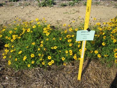 | | 2010 | COLLECTED | 05/29/2010 | East Central Texas Plain. Wilson County. Approximately 5.5 miles northwest of Nixon. Farm-to-Market Road 1681, Near Union Valley Cemetery. | 29.31380000, -97.83930000 | 138 | Savannah. Land form: Stream terrace. Land Use: Roadside easment. Geology: Loamy alluvium. Soil Texture: Loamy sand. Ecological Site Descriptor: Tight sandy Loam. | Wild material | Plants 60 to 75 cm tall; golden yellow ray petals with proximal band of red-brown. | 1897331 | PI 673993 |
| 44 | PI 699412 | TX-52 | Coreopsis nuecensis A. Heller | Texas, United States | OPGC | | | 2010 | COLLECTED | 05/29/2010 | East Central Texas Plain. Wilson County. Approximately 5.5 miles northwest of Nixon. Farm-to-Market Road 1681, Near Union Valley Cemetery. | 29.31380000, -97.83930000 | 138 | Savannah. Land form: Stream terrace. Land Use: Roadside easment. Geology: Loamy alluvium. Soil Texture: Loamy sand. Ecological Site Descriptor: Tight sandy Loam. | Wild material | Plants mown down to about 15 cm tall; Flowers approximately 4 cm in diameter, pale yellow rays with reddish-brown splotches at petal base. | 1897329 | PI 699412 |
| 45 | NA 89174 | 2025RJLSEUS-16 | Kalmia hirsuta Walter | Florida, United States | NA | | | 2026 | COLLECTED | 10/04/2025 | Eglin Air Force Base: collected along Florida National Scenic Trail/Eglin AFB unnamed road. | 30.43936000, -86.84404500 | 7 | Growing in full sun in dry areas above stream. Slope: 0 percent. Aspect: N/A. Soil: The primary soil type in the collection area is classified as Pickney Loamy Sand soils. The Pickney Series consists of very deep, very poorly drained soils. Permeability is rapid. These nearly level soils have negligible runoff and were formed by marine or fluvial sediments in the lower coastal plain on flats, depressions, stream terraces, and flood plains. Slopes range from 0 to 2 percent. The soils of this series are loamy fine sand that is very friable and extremely acid in the upper 0-25 cm. The lower strata are similar, while the lower strata from 0.8-2 meters are comprised of fine sand. (Source: NRCS Web Soil Survey). Geology: The underlying geology of this area is classified as Alluvium, of Pleistocene/Holocene origin and consists of undifferentiated Quaternary sediments of varying thickness including siliciclastics, organics and freshwater carbonates. The siliciclastics are light gray, tan, brown to black, unconsolidated to poorly consolidated, clean to clayey, silty, unfossiliferous, variably organic-bearing sands to blue green to olive green, poorly to moderately consolidated, sandy, silty clays. Organics occur as plant debris, roots, disseminated organic matrix and beds of peat. Freshwater carbonates, often referred to as marls in the literature, are scattered. (Source: USGS Florida Geologic Map Data). | Wild material | | 2193308 | NA 89174 |
| 46 | NA 89173 | 2025RJLSEUS-14 | Chionanthus sp. | Florida, United States | NA | | | 2026 | COLLECTED | 10/03/2025 | Choctawhatchee National Forest: the collection site is reached by foot (~0.5 km) along a loose sand road/firebreak from Martin Luther King, Jr. Boulevard, just east of the boundary for Hurlburt Field in Hurlburt Field/Ft. Walton Beach, FL. Collected from 30 deg. 26.859', -86 deg. 39.577' to 30 deg. 27.137', -86 deg. 39.580'; latitude and longitude of record calculated at the midpoint of these coordinates. | 30.44996000, -86.65965000 | 10 | Dry to xeric conditions of well-drained, deep sandy soils on a relatively level area bordering a powerline in an open mixed mostly mixed evergreen and deciduous, somewhat disturbed habitat in sun to part shade. In areas “broadleaved scrub” vegetation is so dense, that it is almost impenetrable. Elevation: 9 to 11 meters. Slope: 0 to 3 percent. Aspect: Variable. Soil: The soils of this area are characterized as Foxworth Series (95 percent) sand, 0 to 5 percent slopes (8). Other soil series interbedded with the Foxworth Series, vary in percentages from 1-4 percent including Lakeland and Chipley. The Foxworth Series consists of very deep, moderately well to somewhat excessively drained, rapid to very rapid permeable soils on broad uplands and side slopes. They formed in sandy marine or eolian sediments in the Southern Coastal Plain (MLRA 133A), The Eastern Gulf Coast Flatwoods (MLRA 152A), The Atlantic Coast Flatwoods (153A) and the Tidewater Area (153B). Thickness of the grayish brown to light yellowish-brown sand exceeds 2 meters. Reaction ranges from very strongly acid to slightly acid throughout. (Source: California Soil Resource Lab/NRCS Official Soil Series Descriptions). Geology: The underlying geology of this area is characterized as undifferentiated Quaternary Sediments. Much of Florida's surface is covered by a varying thickness of undifferentiated sediments consisting of siliciclastics, organics and freshwater carbonates. Where these sediments exceed 6.1 meters thick, they were mapped as discrete units. To subdivide the undifferentiated sediments, those sediments occurring in flood plains were mapped as alluvial and flood plain deposits (Qal). Sediments showing surficial expression of beach ridges and dunes were mapped separately (Qbd) as were the sediments composing Trail Ridge (Qtr). Terrace sands were not mapped (refer to Healy [1975] for a discussion of the terraces in Florida). The subdivisions of the Undifferentiated Quaternary Sediments (Qu) are not lithostratigraphic units but are utilized to facilitate a better understanding of the State's geology. The siliciclastics are light gray, tan, brown to black, unconsolidated to poorly consolidated, clean to clayey, silty, unfossiliferous, variably organic-bearing sands to blue green to olive green, poorly to moderately consolidated, sandy, silty clays. Gravel is occasionally present in the panhandle. Organics occur as plant debris, roots, disseminated organic matrix and beds of peat. Freshwater carbonates, often referred to as marls in the literature, are scattered over much of the State. In southern Florida, freshwater carbonates are nearly ubiquitous in the Everglades. These sediments are buff colored to tan, unconsolidated to poorly consolidated, fossiliferous carbonate muds. Sand, silt and clay may be present in limited quantities. These carbonates often contain organics. The dominant fossils in the freshwater carbonates are mollusks. (Source: USGS Florida Geologic Map Data). | Wild material | Received as C. cf. henryae | 2193307 | NA 89173 |
| 47 | NA 89113 | TLM25-01 | Zanthoxylum clava-herculis L. | Texas, United States | NA | | | 2025 | COLLECTED | 07/08/2025 | Packery Channel Oak Motte Sanctuary on Padre Island. Plants were growing on the dune edge of the Sanctuary at the intersection of Villa Maria Isabel Avenue and Sand Dollar Avenue. | 27.62564900, -97.21972000 | 3 | Plants are growing in part shade to full sun, deep sandy, and dry conditions. Plants are sheltered from direct impact of winds and surf by the dunes where they reside. The dunes appear relatively stable with a dense "motte" of Quercus fusiformis and other plants species, all of which appear to quite mature. Soils: The soils of this site are classified as Galveston and Mustang fine sands, occasionally flooded (Gm). The Galveston Series (~50%) consists of very deep, somewhat excessively drained, high saturated hydraulic conductivity (rapidly permeable soils) that formed in sandy eolian deposits derived from igneous, metamorphic and sedimentary rock. These nearly level to strongly sloping soils occur on back-barrier flats on barrier islands. Slope ranges from 0 to 3 percent. The soils are occasionally flooded with salt water during severe storms. The Mustang Series (~30%) consists of very deep, poorly drained, very slowly permeable soils that formed in sandy eolian and storm washover sediments. These nearly level soils are on planar to concave barrier island flats. These soils are subject to occasional flooding by high storm surge from strong tropical storms and are ponded after periods of heavy rainfall. Slope ranges from 0 to 1 percent. Galveston and Mustang fine sands range from slightly alkaline to moderately alkaline. (Source: California Soil Resource Lab/NRCS Official Soil Series Descriptions). Geology: The underlying geology of this area is characterized as Barrier Ridge and Barrier Flat Deposits of Quaternary, Holocene origin. It is comprised of sand, silt, and clay; mostly sand, well sorted, and fine grained with abundant shells and shell fragments. Interfingers have silt and clay in landward direction; includes beach ridge, spit, tidal channel, tidal flats, washover fian, and sand dune deposits. (Source: USGS Texas Geologic Map Data). Slope: 1 to 5 percent. Aspect: west to northwest. | Wild material | | 2191652 | NA 89113 |
| 48 | NA 89115 | TLM25-04a | Hamamelis ovalis S. W. Leonard | Texas, United States | NA | | | 2025 | COLLECTED | 07/10/2025 | State Highway 87 approximately 3.25 kilometers north of the crossroad junction with Texas Recreational Road 255 (RE 255); plants were growing in the narrow buffer woods along the east side of the highway. | 31.12051300, -93.72628100 | 138 | The habitat is an upland mixed coniferous and deciduous woodlands in part to full shade and dry conditions, often under drought stress. Plants seem to always occur on the top of dry ridges or well-drained slopes. Slope: 0 to 1 percent. Aspect: N/A. Soils: The soils of this collection area are classified as Tehran-Letney Association, hilly (TLE) soils. The Tehran Series (55%) consists of deep, somewhat excessively drained, moderately rapidly permeable soils on uplands. They formed in thick loamy and sandy sediments on the Western Coastal Plain. These soils are on gently sloping to moderately steep uplands with slopes ranging from 1 to 20 percent. The Letney Series (30%) consists of deep, well drained, moderately rapidly permeable, upland soils. They formed in thick sandy and loamy sediments of the coastal plains. These soils are on gently sloping to moderately steep uplands with slopes ranging from 1 to 20 percent. Soil pH ranges from 4.5 to 6.0. The minor soil components include Doucette Series (10%) and Boykin Series (5%) soils. (Source: California Soil Resource Lab/NRCS Official Soil Series Descriptions). Geology: The underlying geology of this area is of Oligocene origin and characterized as Catahoula Formation. This formation is extensive and deep in Texas, up to 185 meters thick. In the area of the collection the Catahoula Formation is primarily mudstone and sand. The upper 90-150 meters is mudstone that is tuffaceous, and sandy; also, occasionally, with some bentonitic clay. (Source: USGS Texas Geologic Map Data). | Wild material | | 2191654 | NA 89115 |
| 49 | NA 88582 | 2024RJLFL-013 | Cornus florida L. | Florida, United States | NA | | | 2024 | COLLECTED | 11/13/2024 | Woodland edge along the south side of Bud Bass Road (DOF B48), 0.30 kilometers east of the junction with Norman Riley Road. | 30.75753300, -86.80457600 | 39 | Mixed evergreen and deciduous forests in part shade in a mesic- to mesic-dry situation. Slope: 0 percent. Aspect: North. The underlying geology of this area is characterized as Citronelle Formation of the Pliocene period. The Citronelle Formation is widespread in the Gulf Coastal Plain. The type section for the Citronelle Formation, named by Matson (1916), is near Citronelle, Alabama. The Citronelle Formation grades laterally, through a broad facies transition, into the Miccosukee Formation of the eastern Florida panhandle. Coe (1979) investigated the Citronelle Formation in portions of the western Florida panhandle. The Citronelle Formation is a siliciclastic, deltaic deposit that is lithologically similar to, and time equivalent with, the Cypresshead Formation and, at least in part, the Long Key Formation (Cunningham et al., 1998) of the peninsula. In the western panhandle, some of the sediments mapped as Citronelle Formation may be reworked Citronelle. The lithologies are the same and there are few fossils present to document a possible younger age. The Citronelle Formation consists of gray to orange, often mottled, unconsolidated to poorly consolidated, very fine to very coarse, poorly sorted, clean to clayey sands. It contains significant amounts of clay, silt and gravel which may occur as beds and lenses and may vary considerably over short distances. Limonite nodules and limonite-cemented beds are common. Marine fossils are rare but fossil pollen, plant remains and occasional vertebrates are found. Much of the Citronelle Formation is highly permeable. It forms the Sand and Gravel Aquifer of the surficial aquifer system contain organics. The dominant fossils in the freshwater carbonates are mollusks. (Source: USGS Florida Geologic Map Data). The soils of this are characterized as Troup Series loamy sand, 0 to 5 percent slopes. The Troup series consists of very deep, somewhat excessively drained soils that formed in unconsolidated sandy and loamy marine sediments. Troup soils are on ridges and hillslopes. Slopes predominantly range from 0 to 15 percent but range to 45 percent. The soil pH is generally strongly acid. (Source: California Soil Resource Lab/NRCS Official Soil Series Descriptions). | Wild material | | 2169919 | NA 88582 |
| 50 | NA 88584 | 2024RJLFL-016 | Cornus florida L. | Florida, United States | NA | | | 2024 | COLLECTED | 11/14/2024 | Both sides of Kennedy Bridge Road approximately 0.27 kilometers west of the junction with Hurricane Lake South Entrance Road. | 30.93159700, -86.74928000 | 43 | Mesic to mesic-moist conditions in a mixed and deciduous evergreen forest in part shade. Slope: 5 to 10 percent. Aspect: Various. The underlying geology of this area is characterized as Citronelle Formation of the Pliocene period. The Citronelle Formation is widespread in the Gulf Coastal Plain. The type section for the Citronelle Formation, named by Matson (1916), is near Citronelle, Alabama. The Citronelle Formation grades laterally, through a broad facies transition, into the Miccosukee Formation of the eastern Florida panhandle. Coe (1979) investigated the Citronelle Formation in portions of the western Florida panhandle. The Citronelle Formation is a siliciclastic, deltaic deposit that is lithologically similar to, and time equivalent with, the Cypresshead Formation and, at least in part, the Long Key Formation (Cunningham et al., 1998) of the peninsula. In the western panhandle, some of the sediments mapped as Citronelle Formation may be reworked Citronelle. The lithologies are the same and there are few fossils present to document a possible younger age. The Citronelle Formation consists of gray to orange, often mottled, unconsolidated to poorly consolidated, very fine to very coarse, poorly sorted, clean to clayey sands. It contains significant amounts of clay, silt and gravel which may occur as beds and lenses and may vary considerably over short distances. Limonite nodules and limonite-cemented beds are common. Marine fossils are rare but fossil pollen, plant remains and occasional vertebrates are found. Much of the Citronelle Formation is highly permeable. It forms the Sand and Gravel Aquifer of the surficial aquifer system contain organics. The dominant fossils in the freshwater carbonates are mollusks. (Source: USGS Florida Geologic Map Data). The soils of this are characterized as Dothan Series loamy sand, 5 to 8 percent slopes. The Dothan Series consists of very deep, well drained soils that formed in thick beds of unconsolidated, medium to fine-textured marine sediments. Dothan soils are on interfluves. Slopes range from 0 to 15 percent. The surface 0-33 cm is characterized by sandy-loam, well-drained soils that are strongly acid. From 33-200 cm they are characterized by sandy clay loam soils that are more moisture retentive and strongly acid. (Source: California Soil Resource Lab/NRCS Official Soil Series Descriptions). | Wild material | | 2169921 | NA 88584 |
| 51 | NA 88586 | 2024RJLFL-020 | Vaccinium arboreum Marshall | Florida, United States | NA | | | 2024 | COLLECTED | 11/14/2024 | Woodland edge off of Ralf Laurant Road, above the wetland/headwaters of Danley Branch along the edge of a young longleaf pine plantation. | 30.90104300, -86.78878100 | 61 | Edge of a mixed evergreen and deciduous forest in part shade to full sun on a mesic to mesic-dry slope, adjacent to a young longleaf pine plantation. Slope: 3 to 8 percent. Aspect: West. The underlying geology of this area is characterized as Citronelle Formation of the Pliocene period. The Citronelle Formation is widespread in the Gulf Coastal Plain. The type section for the Citronelle Formation, named by Matson (1916), is near Citronelle, Alabama. The Citronelle Formation grades laterally, through a broad facies transition, into the Miccosukee Formation of the eastern Florida panhandle. Coe (1979) investigated the Citronelle Formation in portions of the western Florida panhandle. The Citronelle Formation is a siliciclastic, deltaic deposit that is lithologically similar to, and time equivalent with, the Cypresshead Formation and, at least in part, the Long Key Formation (Cunningham et al., 1998) of the peninsula. In the western panhandle, some of the sediments mapped as Citronelle Formation may be reworked Citronelle. The lithologies are the same and there are few fossils present to document a possible younger age. The Citronelle Formation consists of gray to orange, often mottled, unconsolidated to poorly consolidated, very fine to very coarse, poorly sorted, clean to clayey sands. It contains significant amounts of clay, silt and gravel which may occur as beds and lenses and may vary considerably over short distances. Limonite nodules and limonite-cemented beds are common. Marine fossils are rare but fossil pollen, plant remains and occasional vertebrates are found. Much of the Citronelle Formation is highly permeable. It forms the Sand and Gravel Aquifer of the surficial aquifer system. The dominant fossils in the freshwater carbonates are mollusks. (Source: USGS Florida Geologic Map Data). The surface soil profile is classified as Troup Series loamy sand, 5 to 8 percent slopes. The Troup series consists of very deep, somewhat excessively drained soils formed in unconsolidated sandy and loamy marine sediments. Troup soils are found on ridges and hillslopes. These soils are very strongly acid to strongly acid. (Source: California Soil Resource Lab/NRCS Official Soil Series Descriptions). | Wild material | | 2169923 | NA 88586 |
| 52 | NA 88731 | RonMiller2022-Old Land Place | Gordonia lasianthus (L.) J. Ellis | Florida, United States | NA | | | 2024 | COLLECTED | 04/2022 | Yellow River Marsh State Aquatic Preserve, "Old Land Place" along Weaver River, 1.47 miles south of the confluence with the Yellow River. | 30.55318000, -87.93656000 | 3 | Moist to wet areas in wetland adjacent to the river in association with a range of evergreen and deciduous forest elements. | Wild material | From open-pollinated, but presumed isolated, seeds of NA 87342-H, -J, and -L (three young plants flowering in containers in production during 2024). Seed was harvested over a period roughly from October through December 2024 as fruits matured. From the record of the parent accession, NA 87342: Exact date of collection unknown. | 2170992 | NA 88731 |
| 53 | NA 87837 | TRX241117-02VA | Campsis radicans (L.) Seem. ex Bureau | Virginia, United States | NA | | | 2024 | COLLECTED | 11/17/2024 | Eastern Shore of Virginia National Wildlife Refuge. | 37.13092000, -75.96253000 | 6 | | Wild material | | 2169890 | NA 87837 |
| 54 | NA 89091 | 2024RM-TK-004 | Prunus sp. | Florida, United States | NA | | | 2024 | COLLECTED | 09/05/2024 | Blackwater River Wildlife Management Area: on the south side of Boundary Line Road about 0.32 kilometers west of Deaton Bridge Road along an area edged by a barbed wire fence. | 30.68579800, -86.87964300 | 45 | Plants are growing from part-sun to full sun. Plants are growing in an area that is frequently burned with a lot of [Prunus sp. (orig. listed as Prunus alabamensis)] scattered throughout. This habitat is a longleaf pine-wiregrass community with scattered turkey (Quercus laevis) and blackjack oaks (Quercus incana). There is a slight slope downward. The line of [Prunus sp.] goes along a semi-ditch on the side of a dirt road. The plants probably get a bit more water than the plants out in the open forest. The [Prunus sp.] are most often without any other close woody companions. Slope: 0 percent. Aspect: North. Geology: The underlying geology of this area is probably of lower Pliocene age and characterized as the Citronelle Formation. The Citronelle Formation is widespread in the Gulf Coastal Plain. The type section for the Citronelle Formation, named by Matson (1916), is near Citronelle, Alabama. The Citronelle Formation grades laterally, through a broad facies transition, into the Miccosukee Formation of the eastern Florida panhandle. Coe (1979) investigated the Citronelle Formation in portions of the western Florida panhandle. The Citronelle Formation is a siliciclastic, deltaic deposit that is lithologically similar to, and time equivalent with, the Cypresshead Formation and, at least in part, the Long Key Formation (Cunningham et al., 1998) of the peninsula. In the western panhandle, some of the sediments mapped as Citronelle Formation may be reworked Citronelle. The lithologies are the same and there are few fossils present to document a possible younger age. The Citronelle Formation consists of gray to orange, often mottled, unconsolidated to poorly consolidated, very fine to very coarse, poorly sorted, clean to clayey sands. It contains significant amounts of clay, silt and gravel which may occur as beds and lenses and may vary considerably over short distances. Limonite nodules and limonite-cemented beds are common. Marine fossils are rare but fossil pollen, plant remains and occasional vertebrates are found. Much of the Citronelle Formation is highly permeable. It forms the Sand and Gravel Aquifer of the surficial aquifer system. (Source: USGS Florida Geologic Map Data). Soils: The soil of this area is characterized as Lakeland Series Sand, 0 to 5 percent slopes (21). The Lakeland Series consists of very deep, excessively drained, rapid to very rapidly permeable soils on uplands. They formed in thick beds of eolian or marine and/or fluvio-marine sands in the Southern Coastal Plain MLRA (133A), the Carolina and Georgia Sandhills (MLRA 137), the Eastern Gulf Coast Flatwoods (MLRA 152A) and the Atlantic Coast Flatwoods (MLRA 153A). (Source: California Soil Resource Lab/NRCS Official Soil Series Descriptions). EPA Ecoregion (Level III): Southeastern Plains (65). EPA Ecoregion (Level IV): Southern Pine Plains and Hills (65f). | Wild material | Received as Prunus alabamensis; other collections of this material have proven not to be Prunus serotina var. alabamensis, but actually a species of plum; this will likewise be treated as unidentified material until its species can be ascertained. Collectors' notes refer to the plant by the name under which it was collected. | 2169055 | NA 89091 |
| 55 | NA 88853 | TJK2023FL-048 | Lyonia ferruginea (Walter) Nutt. | Florida, United States | NA | | | 2024 | COLLECTED | 12/26/2023 | South of Highway 98, west of Twine Road. Track has a very large powerline right-of-way to the east, and George Washington Swamp bottom to the west. | 29.77560000, -85.27400000 | 6 | Longleaf Pine-Saw Palmetto. This area appears to be declining in quality, as witnessed by the declining in Rhododendron stem/plant density. Possible contributing issues: lacking necessary fire regime, has not seen fire in 8-10 years, encroaching woody shrub layer, accumulating organic matter (pine needle), expanding tree canopy, Hurricane Michael. Slope: less than 2%. Aspect: Northeast. Elevation: 20 feet. | Wild material | | 2165708 | NA 88853 |
| 56 | WLP 3411 | TJK2023FL-044 | Cyrilla racemiflora L. | Florida, United States | NA |  | | 2024 | COLLECTED | 12/26/2023 | Forest Hill Cemetery, east fence line, 0.4 mi north of Hwy 98, off Twine Rd. | 29.78030000, -85.27160000 | 7 | Growing on the edge of a wet pine savanna/flatwood. Slope: flat. Aspect: Southeast. Elevation: 23 feet. | Wild material | | 2165704 | WLP 3411 |
| 57 | WLP 3412 | TJK2023FL-045 | Lyonia lucida (Lam.) K. Koch | Florida, United States | NA | | | 2024 | COLLECTED | 12/26/2023 | East backwoods adjacent to Forest Hill Cemetery, 0.4 mi north of Hwy 98, off Twine Rd. | 29.78030000, -85.27160000 | 7 | Edge of a wet pine savanna/flatwood. Slope: flat. Aspect: Southeast. Elevation: 23 feet. | Wild material | | 2165705 | WLP 3412 |
| 58 | NA 88828 | RJL-RM2023FLAL-002 | Vaccinium arboreum Marshall | Florida, United States | NA | | | 2023 | COLLECTED | 12/05/2023 | Yellow River Wildlife Management Area, along DOF [Department of Forestry] Y9 dirt road 0.08 kilometers east of Miller Bluff Road. | 30.65289100, -86.87608500 | 44 | Growing in part shade to sun in very dry, highly competitive site still recovering from the logging of pines in the past decade. This young woodland is comprised of a combination of evergreen and deciduous species competing for available resources and light before the young sand pines begin to dominate the upper canopy. Slope: 0 percent. Aspect: N/A. The underlying geology of this area is the Citronelle Formation, of Pliocene origin, and consists of gray to orange, often mottled, unconsolidated to poorly consolidated, very fine to very coarse, poorly sorted, clean to clayey sands. It contains significant amounts of clay, silt and gravel which may occur as beds and lenses and may vary considerably over short distances. Limonite nodules and limonite-cemented beds are common. (Source: USGS Florida Geologic Map Data.) The primary soil type in the collection area is classified as Lakeland Sand soils (0 to 5 percent slopes). The surface soil profile of this area is primarily the Lakeland series which consists of very deep, excessively drained, rapid to very rapidly permeable soils on uplands. They formed in thick beds of eolian or marine and/or fluvio-marine sands. Thickness of the sand exceeds 2 meters. Silt plus clay in the upper meter ranges from 5-10 percent. Reaction ranges from very strongly acid to moderately acid throughout. (Source: NRCS Web Soil Survey.) | Wild material | | 2165658 | NA 88828 |
| 59 | NA 88836 | RJL-RM2023FLAL-010 | Leucothoe axillaris (Lam.) D. Don | Florida, United States | NA | | | 2023 | COLLECTED | 12/08/2023 | Along Gin/Camp Road at the bridge over Thomas Creek on the east side of the road. | 30.75018700, -87.23492900 | 21 | Growing in shade of the moist to wet habitat along Thomas Creek. Plants receive regular moisture and are occasionally flooded in this habitat. Slope: N/A. Aspect: N/A. The underlying geology of this area is the Citronelle Formation of Pliocene origin and consists of gray to orange, often mottled, unconsolidated to poorly consolidated, very fine to very coarse, poorly sorted, clean to clayey sands. It contains significant amounts of clay, silt and gravel which may occur as beds and lenses and may vary considerably over short distances. Limonite nodules and limonite-cemented beds are common. (Source: USGS Florida Geologic Map Data.) The surface soil profile of this area is primarily Bibb-Kinston series association. Bibb series soils are coarse-loamy, sandy, acid soils that are poorly drained. They are soils of flood plains and streams subject to frequent flooding. These are found in association with Kinston series soils that are fine-loamy, sandy, acid soils of flood plains and stream subject to frequent flooding. The Bibb-Kinston association ranges from 1-1.5 meters thick and is strongly acid. (Source: NRCS Web Soil Survey.) | Wild material | | 2165666 | NA 88836 |
| 60 | NA 88839 | RJL-RM2023FLAL-013 | Rhododendron austrinum (Small) Rehder | Florida, United States | NA | | | 2023 | COLLECTED | 12/10/2023 | Along the Florida Trail, accessed from Miller Bluff Road. Plants were found infrequently but regularly along the trail over 1 kilometer or more. | 30.61991500, -86.86521000 | 4 | Plants are growing primarily in shade to dappled shade, above a small stream in moist mesic conditions along and below the Florida Trail. The mixed evergreen and deciduous forest is quite diverse with an excellent litter layer. Slope: 2 to 8 percent. Aspect: South. The underlying geology of this area is classified as Alluvium, of Pleistocene/Holocene origin and consists of undifferentiated Quaternary sediments of varying thickness including siliciclastics, organics and freshwater carbonates. The siliciclastics are light gray, tan, brown to black, unconsolidated to poorly consolidated, clean to clayey, silty, unfossiliferous, variably organic-bearing sands to blue green to olive green, poorly to moderately consolidated, sandy, silty clays. Organics occur as plant debris, roots, disseminated organic matrix and beds of peat. Freshwater carbonates, often referred to as marls in the literature, are scattered. (Source: USGS Florida Geologic Map Data.) The surface soil profile of this area is primarily Bibb-Kinston Series Association. Bibb Series soils are coarse-loamy, sandy, acid soils that are poorly drained. They are soils of flood plains and streams subject to frequent flooding. These are found in association with Kinston Series soils that are fine-loamy, sandy, acid soils of flood plains and stream subject to frequent flooding. The Bibb-Kinston association ranges from 1-1.5 meters thick and is strongly acid. (Source: NRCS Web Soil Survey.) | Wild material | | 2165669 | NA 88839 |
| 61 | NA 88842 | RJL-RM2023FLAL-016 | Pinckneya bracteata (W. Bartram) Raf. | Florida, United States | NA | | | 2023 | COLLECTED | 12/11/2023 | West side of Scott Road in woodlands approximately 0.13 kilometers north of where the road crosses Ecofina Creek. As of 2023, this road appears permanently closed from previous hurricane damage. | 30.55633300, -85.43520000 | 38 | Plants are growing in the understory of a mixed evergreen and deciduous bottomland forest associated with the Ecofina Creek. Plans are growing mostly on hummocks in a very wet, acidic wetland habitat. Slope: N/A. Aspect: N/A. The underlying geology of this area is the Alum Bluff Group of Miocene origin. It includes the Chipola Formation, Oak Grove Sand, Shoal River Formation, Choctawhatchee Formation and the Jackson Bluff Formation. The formations included in this group are generally defined on the basis of their molluscan faunas and stratigraphic position. Puri (1953) described sediment facies as they relate to the formations of the Alum Bluff Group. These sediments are lithologically distinct as a group, not as individual units. The Alum Bluff Group crops out or is beneath a thin overburden in the western panhandle from river valleys in Okaloosa County eastward to western Jackson County. The Alum Bluff Group consists of clays, sands and shell beds which may vary from fossiliferous, sandy clays to unfossiliferous sands and clays and occasional carbonate beds. Mica is a common constituent and glauconite and phosphate occur sporadically. Induration varies from essentially nonindurated in sands to well indurated in carbonate lenses. Colors range from cream to olive gray with mottled reddish brown in weathered sections. Sand grain size varies from very fine to very coarse with sporadic occurrences of gravel. These sediments generally have low permeabilities and are part of the intermediate confining unit/aquifer system. (Source: USGS Florida Geologic Map Data.) The surface soil profile of this area is primarily Pamlico-Pantego-Rutlege Association. The Pamlico series consists of very poorly drained soils that formed in decomposed organic material underlain by dominantly sandy sediment. The soils are on nearly level flood plains, bays, and depressions of the Coastal Plain. Slopes are less than 1 percent. Pamlico soils have 0.4-1.3 meters of organic material over dominantly sandy sediments. Reaction is extremely in the organic layers and ranges from extremely acid to strongly acid in the underlying mineral layers. The Pantego series consists of very deep, very poorly drained, moderately permeable soils that formed in thick loamy sediments on the Southern Coastal Plain and Atlantic Coast Flatwoods. Slopes are less than 2 percent. This soil is strongly acid. The Rutlege series comprises very deep, very poorly drained persistently wet soils on flats, depressions and floodplains where shallow ponding is common. They are of marine or fluvial sediment origin. Thickness of these loamy sandy soils is greater than 1.5 meters and a reaction from extremely acid to strongly acid. (Source: NRCS Web Soil Survey.) | Wild material | | 2165672 | NA 88842 |
| 62 | NA 88844 | RJL-RM2023FLAL-018 | Clethra alnifolia L. | Florida, United States | NA | | | 2023 | COLLECTED | 12/13/2023 | Yellow River Water Management Area, accessed off of Old River Road by vehicle on an unmaintained sand road for approximately 1.68 kilometers. Upon reaching the destination, plants are accessed by foot along unmaintained trail to the east. | 30.83495500, -86.62005400 | 27 | Plants are growing primarily in part shade as understory shrubs in mixed evergreen and deciduous, moist to wet, acidic woodlands. Plants form large colonies and appear to have been subjected to prescribed fire in recent years. Slope: 10 to 15 percent. Aspect: Northeast. The underlying geology of this area is the Citronelle Formation of Pliocene origin and consists of gray to orange, often mottled, unconsolidated to poorly consolidated, very fine to very coarse, poorly sorted, clean to clayey sands. It contains significant amounts of clay, silt and gravel which may occur as beds and lenses and may vary considerably over short distances. Limonite nodules and limonite-cemented beds are common. (Source: USGS Florida Geologic Map Data.) The soil profile for this area is classified as the Bonifay Soil Series. Bonifay soil consists of very deep, well drained, moderately slowly permeable soils on ridges and side slopes in the Southern Coastal Plain. They formed in thick beds of sandy and loamy marine sediments. Solum thickness ranges from 1.5-2.0 m. Soil reaction ranges from very strongly acid to moderately acid throughout, except where the surface has been limed. Ironstone pebbles, 2 to 15 mm in size, range from 0 to 5 percent, by volume. Depth to the plinthic horizon ranges from 1.1-1.7 m. Some horizons contain up to 25 percent plinthite by volume. (Source: NRCS Web Soil Survey.) | Wild material | | 2165674 | NA 88844 |
| 63 | NA 88850 | RJL-RM2023FLAL-024 | Rhododendron austrinum (Small) Rehder | Florida, United States | NA | | | 2023 | COLLECTED | 12/13/2023 | Yellow River Water Management Area, found in an area where an unnamed unpaved road winds along the edges of the Yellow River. This unpaved road is accessed from Old River Road to the east near the junction with Shockley Springs Road. Individuals are found along the roadside for at least 6 kilometers from the point where the unnamed road splits and turns south. | 30.82647700, -86.60892000 | 23 | Plants are growing primarily in part shade to shade in mesic conditions in a mixed evergreen and deciduous forest. Fruiting plants are more abundant where plants receive more sunlight. Slope: 0 to 2 percent. Aspect: Various. The underlying geology of this area is the Alum Bluff Group of Miocene origin. It includes the Chipola Formation, Oak Grove Sand, Shoal River Formation, Choctawhatchee Formation and the Jackson Bluff Formation. The formations included in this group are generally defined on the basis of their molluscan faunas and stratigraphic position. Puri (1953) described sediment facies as they relate to the formations of the Alum Bluff Group. These sediments are lithologically distinct as a group, not as individual units. The Alum Bluff Group crops out or is beneath a thin overburden in the western panhandle from river valleys in Okaloosa County eastward to western Jackson County. The Alum Bluff Group consists of clays, sands and shell beds which may vary from fossiliferous, sandy clays to unfossiliferous sands and clays and occasional carbonate beds. Mica is a common constituent and glauconite and phosphate occur sporadically. Induration varies from essentially nonindurated in sands to well indurated in carbonate lenses. Colors range from cream to olive gray with mottled reddish brown in weathered sections. Sand grain size varies from very fine to very coarse with sporadic occurrences of gravel. These sediments generally have low permeabilities and are part of the intermediate confining unit/aquifer system. (Source: USGS Florida Geologic Map Data.) The surface soil profile of this area is primarily Yemassee, Garcon, and Bigbee soils that are occasionally flooded. The Yemassee Series consists of very deep, somewhat poorly drained, moderately permeable, loamy soils that formed in marine sediments. These soils are on terraces and broad flats of the lower Coastal Plain and very strongly acid. Slopes range from 0 to 2 percent. The Garcon Series consists of very deep, somewhat poorly drained, moderately permeable soils on terraces and in the broad flats of the lower Coastal Plain. They formed in sandy and loamy marine sediments. This soil ranges from very strongly acid to extremely acid. The Bigbee series consists of very deep, excessively drained, rapidly permeable soils that are on natural levees and higher positions in flood plains along stream flood plains in the Southern Coastal Plain (MLRA 133A) and the Eastern Gulf Coast Flatwoods (MLRA 152A). They formed in thick sandy alluvial sediments. They range from strongly acid to very strongly acid. (Source: NRCS Web Soil Survey.) | Wild material | | 2165680 | NA 88850 |
| 64 | WLP 3377 | TXWL2023-024 | Viburnum dentatum L. | Texas, United States | NA | | | 2023 | COLLECTED | 12/13/2023 | Roadside between Big Cow Creek and Hardy Cemetery. | 31.03548900, -93.85086800 | | Roadside; mesic, mixed hardwood/pine forest. | Wild material | | 2165656 | WLP 3377 |
| 65 | NA 88806 | TJK2023LA/TX-006 | Vaccinium arboreum Marshall | Texas, United States | NA | | | 2023 | COLLECTED | 11/21/2023 | Interstate 20, westbound, approximately 2.2 miles west of FM (farm-to-market road) 2015 and 0.8 miles east of FM 14. | 32.45250000, -95.26960000 | 10 | Xeric shortleaf pine-post oak-blackjack oak uplands. Slope: flat. Aspect: West. Elevation: 32 feet. | Wild material | | 2159189 | NA 88806 |
| 66 | NA 88683 | TJK2023FL-030 | Vaccinium arboreum Marshall | Florida, United States | NA | | | 2023 | COLLECTED | 11/16/2023 | Pensacola State College, Midway Campus, 1/8 mile south of Highway 98. | 30.39710000, -87.01040000 | 10 | Sand Pine Scrub, old remnant sand dune. Slope: flat. Aspect: West. Elevation: 32 feet. | Wild material | | 2159095 | NA 88683 |
| 67 | NA 88684 | TJK2023FL-031 | Smilax smallii Morong | Florida, United States | NA | | | 2023 | COLLECTED | 11/18/2023 | T. Kiphart residence, Navarre, Florida. | 30.40680000, -86.93090000 | 12 | Moist, urban woods. Slope: 3%. Aspect: South. Elevation: 39 feet. | Wild material | | 2159096 | NA 88684 |
| 68 | WLP 3274 | TJK2023FL-022 | Smilax auriculata Walter | Florida, United States | NA | | | 2023 | COLLECTED | 10/20/2023 | Santa Rosa Island: White Sands Blvd, Navarre Beach at Santa Rosa Sound, soundside. | 30.37828000, -86.89761000 | 6 | First dunes off the sound. Slope: 30%. Aspect: West. Elevation: 21 feet. | Wild material | | 2159054 | WLP 3274 |
| 69 | WLP 3275 | TJK2023FL-023 | Morella cerifera (L.) Small | Florida, United States | NA | | | 2023 | COLLECTED | 10/20/2023 | Santa Rosa Island: White Sands Blvd, Navarre Beach at Santa Rosa Sound, soundside. | 30.37880000, -86.89770000 | 2 | Woody transition belt between sound-side marsh vegetation and fore dune vegetation. Plants experience saltwater intrusion. Slope: 7%. Aspect: Northwest. Elevation: 5 feet. | Wild material | | 2159055 | WLP 3275 |
| 70 | NA 88668 | TXWL2023-011 | Amorpha paniculata Torr. & A. Gray | Texas, United States | NA | | | 2023 | COLLECTED | 10/02/2023 | Angelina National Forest: Forest Service Road 302A roadside [Note: GPS coordinates are west of FS Road 302A, closer to County Road 348B.] | 31.09190000, -94.29072400 | | Roadside. | Wild material | | 2159043 | NA 88668 |
| 71 | NA 89013 | TJK2023FL-021 | Smilax pumila Walter | Florida, United States | NA | | | 2023 | COLLECTED | 10/15/2023 | Collected at 1985 Reagan Rd in Navarre, Florida. | 30.40680000, -86.93090000 | 9 | Disturbed native residential woods. Elevation: 32 feet. Slope: 3%. Aspect: Southeast. | Wild material | | 2158906 | NA 89013 |
| 72 | NA 88660 | TJK2023FL-014 | Rhododendron austrinum (Small) Rehder | Florida, United States | NA | | | 2023 | COLLECTED | 09/15/2023 | Lower Yellow River, Grimes Lake. | 30.61930000, -86.81490000 | 3 | Elevation: 13 feet. Slope: 0 percent. Aspect: West-southwest. | Wild material | | 2158794 | NA 88660 |
| 73 | NA 88663 | TJK2023FL-017 | Rhododendron austrinum (Small) Rehder | Florida, United States | NA | | | 2023 | COLLECTED | 09/17/2023 | Lower Yellow River, below the Old Land Place. | 30.55513000, -86.94659000 | 0 | An area with very nice Pink R. austrinum. Elevation: 0. Slope: 0 percent. Aspect: South-southwest. | Wild material | | 2158797 | NA 88663 |
| 74 | WLP 3214 | TXWL2023-002 | Stewartia malacodendron L. | Texas, United States | NA | | | 2023 | COLLECTED | 08/27/2023 | Little Cow Creek. | 31.06090300, -93.79570300 | | Mesic mixed hardwood-pine forest adjacent to riparian area. Some blowdown evident. | Wild material | | 2158758 | WLP 3214 |
| 75 | WLP 3215 | TXWL2023-003 | Stewartia malacodendron L. | Texas, United States | NA | | | 2023 | COLLECTED | 08/27/2023 | Little Cow Creek. | 31.06228800, -93.79734300 | | Mesic mixed hardwood-pine forest adjacent to riparian area. Some blowdown evident. | Wild material | | 2158759 | WLP 3215 |
| 76 | NA 89263 | TJK2023FL-001 | Smilax laurifolia L. | Florida, United States | NA | | | 2023 | COLLECTED | 01/18/2023 | Midway, Florida: Pensacola State College, 1/4 mile south of Highway 98, west of main road towards main building. | 30.39570000, -87.01300000 | 8 | Ilex myrtifolia depressional wetland. Slope: 2%. Aspect: Southeast. Elevation recorded as 25 feet. | Wild material | WLPGR contract collection. | 2158246 | NA 89263 |
| 77 | NA 89264 | TJK2023FL-002 | Gaylussacia frondosa (L.) Torr. & A. Gray var. nana A. Gray | Florida, United States | NA | | | 2023 | COLLECTED | 05/19/2023 | Blackwater State Forest: Wolfe Creek. | 30.80760000, -86.96250000 | 49 | Beautiful xeric pine-oak upland community. Transitions to mesic slopes and then to seepage bottom, stringer wetland community adjacent to the Wolfe Creek. Area is on a regular 2-4[-year] burn cycle. Slope: 5%. Aspect: Northwest. Elevation recorded as 161 feet. | Wild material | WLPGR contract collection. Received as Gaylussacia tomentosa (nana). | 2158247 | NA 89264 |
| 78 | NA 89265 | TJK2023FL-003 | Ceanothus sp. | Florida, United States | NA | | | 2023 | COLLECTED | 05/19/2023 | Blackwater State Forest: Wolfe Creek. | 30.80650000, -86.95840000 | 49 | Beautiful xeric pine-oak upland community. Transitions to mesic slopes and then to seepage bottom, stringer wetland community adjacent to the Wolfe Creek. Slope: 20%. Aspect: Northwest. Elevation recorded as 162 feet. | Wild material | WLPGR contract collection. Received as Ceanothus microphyllus. | 2158248 | NA 89265 |
| 79 | NA 89266 | TJK2023FL-004 | Gaylussacia dumosa (Andrews) Torr. & A. Gray | Florida, United States | NA | | | 2023 | COLLECTED | 05/31/2023 | Blackwater State Forest: Wolfe Creek. | 30.80560000, -86.95890000 | 49 | Beautiful xeric pine-oak upland community. Transitions to mesic slopes and then to seepage bottom, stringer wetland community adjacent to the Wolfe Creek. Slope: 15%. Aspect: Northwest. Elevation recorded as 160 feet. | Wild material | WLPGR contract collection. | 2158249 | NA 89266 |
| 80 | NA 89267 | TJK2023FL-005 | Ceanothus americanus L. | Florida, United States | NA | | | 2023 | COLLECTED | 06/10/2023 | Blackwater State Forest: Wolfe Creek. | 30.80760000, -86.96250000 | 49 | Beautiful xeric pine-oak upland community. Transitions to mesic slopes and then to seepage bottom, stringer wetland community adjacent to the Wolfe Creek. Area is on a regular 2-4[-year] burn cycle. Slope: 5%. Aspect: Northwest. Elevation recorded as 161 feet. | Wild material | WLPGR contract collection. | 2158250 | NA 89267 |
| 81 | NA 89269 | TJK2023FL-007 | Vaccinium darrowii Camp | Florida, United States | NA | | | 2023 | COLLECTED | 06/10/2023 | Blackwater State Forest: Wolfe Creek. | 30.80560000, -86.95770000 | 60 | Beautiful xeric pine-oak upland community. Transitions to mesic slopes and then to seepage bottom, stringer wetland community adjacent to the Wolfe Creek. Area is on a regular 2-4[-year] burn cycle. Slope: 2%. Aspect: West-northwest. Elevation recorded as 197 feet. | Wild material | WLPGR contract collection. | 2158252 | NA 89269 |
| 82 | NA 89271 | TJK2023FL-009 | Vaccinium stamineum L. | Florida, United States | NA | | | 2023 | COLLECTED | 07/16/2023 | Eglin Air Force Base: Weaver Creek area west of Highway 87, north of Choctaw Nolf Airfield Road (Escrobano Point). | 30.50710000, -86.91220000 | 33 | Xeric oak-pine uplands above Weaver Creek Bayhead. Slope: 5%. Aspect: Northwest. Elevation recorded as 107 feet. | Wild material | WLPGR contract collection. | 2158254 | NA 89271 |
| 83 | NA 87774 | RM2023-001 | Kosteletzkya pentacarpos (L.) Ledeb. | Florida, United States | NA | | | 2023 | COLLECTED | 09/01/2022 | This plant is growing in emergent wetlands along pipeline right-of-way on the Simpson River in the Yellow River estuary. The species is common along the Yellow River. | 30.59297000, -87.21380000 | 1 | This plant was found growing in full sun in permanently saturated to submersed conditions along the edge of the Simpson River, in dense herbaceous aquatic islands.
Soils: The underlying geology of this area is classified as Alluvium, of Pleistocene/Holocene origin and consists of undifferentiated Quaternary sediments of varying thickness including siliciclastics, organics and freshwater carbonates. The siliciclastics are light gray, tan, brown to black, unconsolidated to poorly consolidated, clean to clayey, silty, unfossiliferous, variably organic-bearing sands to blue green to olive green, poorly to moderately consolidated, sandy, silty clays. Organics occur as plant debris, roots, disseminated organic matrix and beds of peat. Freshwater carbonates, often referred to as marls in the literature, are scattered.
Source: USGS Florida Geologic Map Data (https://mrdata.usgs.gov/geology/state/state.php?state=fl)
The surface soil profile of this area is primarily Chewacla-Wahee-Riverview Association. The Chewacla Series soils are dark yellowish brown silty clay loam soils, that are strongly acidic and somewhat poorly drained. They are soils of flood plains and streams subject to frequent flooding. The Wahee Series soils are dark gray clayey and loamy marine or fluviomarine sediments that are strongly acidic and somewhat poorly drained. The Riverview series consists of very deep, well drained, moderately permeable soils that formed in loamy alluvium on flood plains. Slopes range from 0 to 5 percent.
Source: NRCS Web Soil Survey (https://websoilsurvey.sc.egov.usda.gov/App/WebSoilSurvey.aspx) | Wild material | | 2141437 | NA 87774 |
| 84 | WLP 3087 | RM2023-005 | Rhododendron minus Michx. var. minus | Alabama, United States | NA | | | 2023 | COLLECTED | 12/29/2022 | This plant is growing along the edges of Gantt Lake, accessed by boat. Occasional in shaded areas around Gantt Lake. | 31.40780000, -86.46770000 | 68 | The plants were growing in open conditions on a steep north-facing bluff above Gantt Lake.
Soils: The underlying geology of this area is Claiborne Group, Tallahatta Formation, of Eocene origin, with white to very light-greenish-gray thin-bedded to massive siliceous claystone; interbedded with thin layers of fossiliferous clay, sandy clay, and glauconitic sand and sandstone.
Source: USGS Alabama Geological Map Data (https://mrdata.usgs.gov/geology/state/state.php?state=AL)
The surface soil profile of this area is primarily Eunola Series Loamy Fine Sand (0 to 2 percent slopes, rarely flooded). The Eunola series consists of very deep, moderately well drained, moderately permeable loamy soils that formed in fluvial or marine sediments. They are on low stream or marine terraces of the Southern Coastal Plain. They are strongly acid. Slopes are dominantly 0 to 3 percent but range up to 6 percent.
Source: NRCS Web Soil Survey (https://websoilsurvey.sc.egov.usda.gov/App/WebSoilSurvey.aspx) | Wild material | | 2141441 | WLP 3087 |
| 85 | WLP 3088 | RM2023-006 | Kalmia latifolia L. | Alabama, United States | NA | | | 2023 | COLLECTED | 12/29/2022 | This plant is growing along the edges of Gantt Lake, accessed by boat. Occasional in shaded areas around Gantt Lake. | 31.40780000, -86.46770000 | 68 | The plants were growing in open conditions on a steep north-facing bluff above Gantt Lake.
Soils: The underlying geology of this area is Claiborne Group, Tallahatta Formation, of Eocene origin, with white to very light-greenish-gray thin-bedded to massive siliceous claystone; interbedded with thin layers of fossiliferous clay, sandy clay, and glauconitic sand and sandstone.
Source: USGS Alabama Geological Map Data (https://mrdata.usgs.gov/geology/state/state.php?state=AL)
The surface soil profile of this area is primarily Eunola Series Loamy Fine Sand (0 to 2 percent slopes, rarely flooded). The Eunola series consists of very deep, moderately well drained, moderately permeable loamy soils that formed in fluvial or marine sediments. They are on low stream or marine terraces of the Southern Coastal Plain. They are strongly acid. Slopes are dominantly 0 to 3 percent but range up to 6 percent.
Source: NRCS Web Soil Survey (https://websoilsurvey.sc.egov.usda.gov/App/WebSoilSurvey.aspx) | Wild material | | 2141442 | WLP 3088 |
| 86 | WLP 3089 | RM2023-007 | Oxydendrum arboreum (L.) DC. | Alabama, United States | NA | | | 2023 | COLLECTED | 12/29/2022 | This plant is growing along the edges of Gantt Lake, accessed by boat. Occasional around Gantt Lake. | 31.41156000, -86.46920000 | 70 | The plants were growing in open sunny conditions on a steep east-facing bluff above Gantt Lake.
Soils: The underlying geology of this area is Claiborne Group, Tallahatta Formation, of Eocene origin, with white to very light-greenish-gray thin-bedded to massive siliceous claystone; interbedded with thin layers of fossiliferous clay, sandy clay, and glauconitic sand and sandstone.
Source: USGS Alabama Geological Map Data (https://mrdata.usgs.gov/geology/state/state.php?state=AL)
The surface soil profile of this area is primarily Eunola Series Loamy Fine Sand (0 to 2 percent slopes, rarely flooded). The Eunola series consists of very deep, moderately well drained, moderately permeable loamy soils that formed in fluvial or marine sediments. They are on low stream or marine terraces of the Southern Coastal Plain. They are strongly acid. Slopes are dominantly 0 to 3 percent but range up to 6 percent.
Source: NRCS Web Soil Survey (https://websoilsurvey.sc.egov.usda.gov/App/WebSoilSurvey.aspx) | Wild material | | 2141443 | WLP 3089 |
| 87 | WLP 3090 | RM2023-008 | Lyonia lucida (Lam.) K. Koch | Alabama, United States | NA | | | 2023 | COLLECTED | 12/29/2022 | This plant is growing along the steep edges of Gantt Lake, accessed by boat. Occasional in shaded areas around Gantt Lake. | 31.40780000, -86.46770000 | 68 | The plants were growing in open conditions on a steep north-facing bluff above Gantt Lake.
Soils: The underlying geology of this area is Claiborne Group, Tallahatta Formation, of Eocene origin, with white to very light-greenish-gray thin-bedded to massive siliceous claystone; interbedded with thin layers of fossiliferous clay, sandy clay, and glauconitic sand and sandstone.
Source: USGS Alabama Geological Map Data (https://mrdata.usgs.gov/geology/state/state.php?state=AL)
The surface soil profile of this area is primarily Bibb-Kinston Series Association. Bibb Series soils are coarse-loamy, sandy, acid soils that are poorly drained. They are soils of flood plains and streams subject to frequent flooding. These are found in association with Kinston Series soils that are fine-loamy, sandy, acid soils of flood plains and stream subject to frequent flooding. The Bibb-Kinston association ranges from 1-1.5 meters thick and is strongly acid.
Source: Soil Survey of Santa Rosa County and NRCS Web Soil Survey (https://www.nrcs.usda.gov/Internet/FSE_MANUSCRIPTS/florida/FL113/0/SantaRosa.pdf and https://websoilsurvey.sc.egov.usda.gov/App/WebSoilSurvey.aspx) | Wild material | | 2141444 | WLP 3090 |
| 88 | NA 87351 | TJK2022FL-006 | Aronia arbutifolia (L.) Pers. | Florida, United States | NA | | | 2023 | COLLECTED | 12/31/2022 | Santa Rosa County: Midway: Pensacola State College, South Santa Rosa Center (Santa Rosa County School District), 1/4 mile south of Highway 98. | 30.39570000, -87.01300000 | 0 | Very interesting site. Interior flooded wetland dominated by Ilex cassine and Ilex myrtifolia. Xeric ridges in wetland have both Cladonia cristella and Cladonia perforata, xeric edges dominated by Pinus clausa. Cyrilla, in seed, consistently dwarfed 16 inches to 6 feet tall, probably due to hydrological and edaphic factors. | Wild material | | 2141642 | NA 87351 |
| 89 | NA 87814 | RM-TK2022-003 | Nyssa ogeche W. Bartram ex Marshall | Florida, United States | NA | | | 2023 | COLLECTED | 09/06/2022 | Hightower Landing on Holmes Creek, off of Hightower Road. This location is off of Florida State Hwy. 79. | 30.60539000, -85.76513400 | 5 | Trees growing on the edge of the water along Holmes Creek.
Soils: The underlying geology of this area is classified as Alluvium of Pleistocene/Holocene origin and consists of undifferentiated Quaternary sediments of varying thickness including siliciclastics, organics and freshwater carbonates. The siliciclastics are light gray, tan, brown to black, unconsolidated to poorly consolidated, clean to clayey, silty, unfossiliferous, variably organic-bearing sands to blue green to olive green, poorly to moderately consolidated, sandy, silty clays. Organics occur as plant debris, roots, disseminated organic matrix and beds of peat. Freshwater carbonates, often referred to as marls in the literature, are scattered.
Source: USGS Florida Geologic Map Data (https://mrdata.usgs.gov/geology/state/state.php?state=fl)
The primary soil types in the collection area are classified as Rutlege, Pickney and Pamlico soils, frequently flooded. The Rutlege series comprises very deep, very poorly drained persistently wet soils on flats, depressions and floodplains where shallow ponding is common. They are of marine or fluvial sediment origin. Thickness of these loamy sandy soils is greater than 1.5 meters and a reaction from extremely acid to strongly acid. The Pickney Series consists of very deep, very poorly drained soils. Permeability is rapid. These nearly level soils have negligible runoff and were formed by marine or fluvial sediments in the lower coastal plain on flats, depressions, stream terraces, and flood plains. Slopes range from 0 to 2 percent. The soils of this series are loamy fine sand that is very friable and extremely acid in the upper 0-25 cm. The lower strata are similar, while the lower strata from 0.8-2 meters are comprised of fine sand. The Pamlico series consists of very poorly drained soils that formed in decomposed organic material underlain by dominantly sandy sediment. The soils are on nearly level flood plains, bays, and depressions of the Coastal Plain. Slopes are less than 1 percent. Pamlico soils have 0.4-1.3 meters of organic material over dominantly sandy sediments. Reaction is extremely in the organic layers and ranges from extremely acid to strongly acid in the underlying mineral layers.
Source: NRCS Web Soil Survey (https://websoilsurvey.sc.egov.usda.gov/App/WebSoilSurvey.aspx) | Wild material | | 2140796 | NA 87814 |
| 90 | NA 88519 | RM-TK2022-007 | Viburnum dentatum L. | Mississippi, United States | NA | | | 2023 | COLLECTED | 10/06/2022 | Along the edge of Red Creek near the Ramsey Springs boat ramp off of Mississippi State Hwy. 15. | 30.77390000, -88.91460000 | 19 | Plants growing on the slight ridges above Black Creek. Soils: The underlying geology of this area is classified as Pascagoula and Hattiesburg Formation of Miocene origin. This formation consists of green and bluish-green clay, sandy clay, and sand; gray siltstone and sand; locally fossiliferous. (Source: USGS Mississippi Geologic Map Data). The primary soil types in this collection area are Jena-Nugent complex soils (frequently flooded). The Jena Series consists of deep, well drained, moderately permeable soils that formed in thick loamy sediments on recent alluvial plains. These soils are on slightly convex natural levees of streams in the Coastal Plains. Water runs off the surface at a negligible to low rate. Slope is dominantly less than 1 percent, but ranges up to 3 percent. The Nugent Series consists of deep, excessively drained soils that formed in sandy alluvium that has thin strata of finer textured material. Permeability is moderately rapid. These soils are on natural levees on flood plains of streams that drain uplands of the Southern Coastal Plain. Slopes are 0 to 2 percent. These soils are strongly acid. (Source: NRCS Web Soil Survey). | Wild material | | 2140800 | NA 88519 |
| 91 | NA 88522 | RM-TK2022-010 | Viburnum dentatum L. var. scabrellum Torr. & A. Gray | Florida, United States | NA | | | 2023 | COLLECTED | 10/10/2022 | Plants growing in woodlands via an unnamed dirt road accessed from Old Ferry Road. | 30.91880000, -87.25990000 | 43 | Plants are growing in an upland habitat on the edge of south-facing woodland in part-shade.
Soils: The underlying geology of this area is classified as Alluvium of Pleistocene/Holocene origin and consists of undifferentiated Quaternary sediments of varying thickness including siliciclastics, organics and freshwater carbonates. The siliciclastics are light gray, tan, brown to black, unconsolidated to poorly consolidated, clean to clayey, silty, unfossiliferous, variably organic-bearing sands to blue green to olive green, poorly to moderately consolidated, sandy, silty clays. Organics occur as plant debris, roots, disseminated organic matrix and beds of peat. Freshwater carbonates, often referred to as marls in the literature, are scattered.
Source: USGS Florida Geologic Map Data (https://mrdata.usgs.gov/geology/state/sgmc-unit.php?unit=FLPSHal%3B0)
The primary soil type in the collection area is classified as Orangeburg sandy loam soil (2 to 5 percent slopes). The Orangeburg Series consists of very deep, well drained, moderately permeable soils on uplands of the Southern Coastal Plain. They formed in loamy and clayey marine sediments. The reaction of all this soil ranges from very strongly acid to strongly acid.
Source: NRCS Web Soil Survey (https://websoilsurvey.sc.egov.usda.gov/App/WebSoilSurvey.aspx) | Wild material | | 2140803 | NA 88522 |
| 92 | NA 88526 | RM-TK2022-014 | Oxydendrum arboreum (L.) DC. | Florida, United States | NA | | | 2023 | COLLECTED | 11/06/2022 | Growing along an unnamed dirt road leading to “Old Land Place” on the edge of Eglin AFB accessed from the Yellow River. | 30.55320000, -86.93730000 | 2 | The underlying geology of this area is classified as Alluvium of Pleistocene/Holocene origin and consists of undifferentiated Quaternary sediments of varying thickness including siliciclastics, organics and freshwater carbonates. The siliciclastics are light gray, tan, brown to black, unconsolidated to poorly consolidated, clean to clayey, silty, unfossiliferous, variably organic-bearing sands to blue green to olive green, poorly to moderately consolidated, sandy, silty clays. Organics occur as plant debris, roots, disseminated organic matrix and beds of peat. Freshwater carbonates, often referred to as marls in the literature, are scattered.
Source: USGS Florida Geologic Map Data (https://mrdata.usgs.gov/geology/state/state.php?state=fl)
The surface soil profile of this area is primarily Bibb-Kinston Series Association. Bibb Series soils are coarse-loamy, sandy, acid soils that are poorly drained. They are soils of flood plains and streams subject to frequent flooding. These are found in association with Kinston Series soils that are fine-loamy, sandy, acid soils of flood plains and stream subject to frequent flooding. The Bibb-Kinston association ranges from 1-1.5 meters thick and is strongly acid.
Source: Soil Survey of Santa Rosa County and NRCS Web Soil Survey (https://www.nrcs.usda.gov/Internet/FSE_MANUSCRIPTS/florida/FL113/0/SantaRosa.pdf and https://websoilsurvey.sc.egov.usda.gov/App/WebSoilSurvey.aspx) | Wild material | | 2140807 | NA 88526 |
| 93 | NA 88543 | RJLSEUS2022-015 | Rhododendron alabamense Rehder | Georgia, United States | NA | | | 2023 | COLLECTED | 12/09/2022 | Plants growing above a pond in drier upland conditions as well as along the banks of the Muckalee Creek on the property of Monica Williams north of Albany, Georgia. Infrequent, but occasionally seen in drier woods; more common along Muckalee Creek. | 31.63566400, -84.13379600 | 61 | Plants are growing in part-shade to shade of well-drained to drier understory conditions of a mixed evergreen and deciduous woodland, approximately 2 meters above Muckalee Creek, on sandy benches where occasional scouring has resulted in lower competition. Plants are occasionally impacted by flooding; however, they are not subjected to extended periods of high moisture on a regular basis.
Soils: The underlying geology of this area is of Eocene origin and characterized as Ocala Limestone. The Ocala Limestone consists of almost pure limestones with occasional dolomites. It can be subdivided into both lower and upper facies with the lower facies composed of a whitish to cream-colored, fine to medium grained, poorly to moderately hard, fossil rich grainstone and packstone. The upper Ocala is white and somewhat weak and poorly sorted. It is extremely fossil rich grainstone, packstone and wackestone and some chert is common in the upper facies.
Source: USGS Georgia Geologic Map Data (https://mrdata.usgs.gov/geology/state/sgmc-unit.php?unit=GANu%3B1)
The primary soil types in the collection area are classified as Herod and Muckalee Series soils. The Herod Series consists of poorly drained moderately permeable soils formed in loamy alluvium. These soils are on flood plains of streams in the Coastal Plain. Slopes range from 0 to 2 percent. The Muckalee Series consists of poorly drained moderately permeable soils formed in loamy and sandy alluvium. These soils are on flood plains of streams in the Coastal Plain. Slopes range from 0 to 2 percent.
Source: NRCS Web Soil Survey (https://websoilsurvey.sc.egov.usda.gov/App/WebSoilSurvey.aspx) | Wild material | | 2140769 | NA 88543 |
| 94 | NA 88559 | RJLSEUS2022-032 | Rhododendron colemanii R. F. Mill. | Alabama, United States | NA | | | 2023 | COLLECTED | 12/12/2022 | Plants growing in bottomland mostly deciduous woodlands on the south side of Lena Landegger Hwy (Monroe County Road 39) about 0.5 kilometers south of the entrance to the Alabama River Cellulose plant. Common at this site. | 31.56879700, -87.49589500 | 10 | Plants are growing in shade of a moist mesic (occasionally temporarily wet) deciduous woodland less than 1 meter above wetland habitats associated with the nearby Alabama River.
Soils: The underlying geology of this area is of Holocene origin and characterized as Alluvial, coastal and low terrace deposits. Varicolored fine to coarse quartz sand containing clay lenses and gravel in places.
Source: USGS Alabama Geologic Map Data (https://mrdata.usgs.gov/geology/state/sgmc-unit.php?unit=ALHalt%3B0)
The primary soil types in the collection area are classified as Chrysler Silt Loam soils (0 to 5 percent slopes, occasionally flooded). The Chrysler Series consists of deep, moderately well drained, slowly permeable soils that formed in clayey fluvial or alluvial sediments. These soils are on stream terraces of the Coastal Plain. They are strongly acid. The rate at which water runs off the surface is medium to rapid. Slopes range from 0 to 5 percent.
Source: NRCS Web Soil Survey (https://websoilsurvey.sc.egov.usda.gov/App/WebSoilSurvey.aspx) | Wild material | | 2140784 | NA 88559 |
| 95 | NA 88562 | RJLSEUS2022-035 | Kalmia latifolia L. | Alabama, United States | NA | | | 2023 | COLLECTED | 12/12/2022 | Plants growing on both sides of River Ridge Road accessed from Alabama State Hwy 41 via Tin Cup Alley Road. Common at this site | 31.73823700, -87.35821100 | 132 | Plants are growing in part-shade to full sun on top of a very exposed ridge top under dry conditions.
Soils: The underlying geology of this area is of Eocene origin and characterized as Claiborne Group; Gosport Sand and Lisbon Formation Undifferentiated in part. Greenish-gray calcareous, glauconitic, fossiliferous clayey sand; marl; carbonaceous sand; carbonaceous silty clay; and coarse glauconitic, fossiliferous, quartz sand.
Source: USGS Alabama Geological Map Data (https://mrdata.usgs.gov/geology/state/state.php?state=AL)
The primary soil types in the collection area are classified as Saffell Very Gravelly Sandy Loam soil (5 to 8 percent slopes). The Saffell Series consists of very deep, well drained, moderately permeable soils that formed in loamy and gravelly marine sediments of the Tertiary Age and have acid reaction. These soils are found on the upper portion of the bluffs along the Alabama River.
Source: NRCS Web Soil Survey (https://websoilsurvey.sc.egov.usda.gov/App/WebSoilSurvey.aspx) | Wild material | | 2140787 | NA 88562 |
| 96 | NA 88564 | RJLSEUS2022-037 | Aronia arbutifolia (L.) Pers. | Florida, United States | NA | | | 2023 | COLLECTED | 12/14/2022 | Plants growing along the west side of Eglin AFB Choctaw Nolf Road northwest of Choctaw Navy Outlying Field. This road goes west and takes circuitous route to the north around the Field enroute to Escribano Point Wildlife Management Area. Frequent in wet areas. | 30.52667900, -86.96485200 | 60 | Plants are growing in part-shade to full sun of moist to wet depressions in areas where wetland herbaceous plants dominate allowing for more light.
Soils: The underlying geology of this area is the Citronelle Formation, of Pliocene origin, and consists of gray to orange, often mottled, unconsolidated to poorly consolidated, very fine to very coarse, poorly sorted, clean to clayey sands. It contains significant amounts of clay, silt and gravel which may occur as beds and lenses and may vary considerably over short distances. Limonite nodules and limonite-cemented beds are common. Source: USGS Florida Geologic Map Data (https://mrdata.usgs.gov/geology/state/state.php?state=fl)
The surface soil profile of this area is primarily Dorovan-Pamlico Series Association. The Dorovan Series consists of very deep, very poorly drained, moderately permeable soils on densely forested flood plains, hardwood swamps and Southern Coastal Plain Major Land Resource Areas. They were formed in highly decomposed acid-organic materials. Slopes are less than 1 percent. The organic material ranges from 1.3-2.1 meters thick. Reaction is extremely acid to very strongly acid in the organic layers and very strongly acid or strongly acid in the mineral layers. The Pamlico Series consists of very poorly drained soils that formed in decomposed organic material underlain by dominantly sandy sediment. The soils are on nearly level flood plains, bays, and depressions of the Coastal Plain. Slopes are less than 1 percent. Pamlico soils have 0.4-1.3 meters of organic material over dominantly sandy sediments. Reaction is extremely in the organic layers and ranges from extremely acid to strongly acid in the underlying mineral layers.
Source: NRCS Web Soil Survey (https://websoilsurvey.sc.egov.usda.gov/App/WebSoilSurvey.aspx) | Wild material | | 2140821 | NA 88564 |
| 97 | NA 88566 | RJLSEUS2022-039 | Rhododendron viscosum (L.) Torr. | Florida, United States | NA | | | 2023 | COLLECTED | 12/14/2022 | Plants growing in woodlands at Escribano Point Bayou Campground not far from the parking lot. Occasional. | 30.50990400, -87.00414900 | 1 | Plants are growing in shade to part-shade of dense mesic vegetation only a few meters from the edge of mixed evergreen and deciduous woodland associated with the Yellow River Marsh Aquatic Preserve. While this habitat is typical mesic and well-drained, it is clearly subject to periods of inundation from high tides or storms as it is a meter or less above the marsh habitat. Additionally, it seems likely that there is plentiful moisture further down in the soil profile based on some of the plant associates.
Soils: The underlying geology of this area is classified as Alluvium, of Pleistocene/Holocene origin and consists of undifferentiated Quaternary sediments of varying thickness including siliciclastics, organics and freshwater carbonates. The siliciclastics are light gray, tan, brown to black, unconsolidated to poorly consolidated, clean to clayey, silty, unfossiliferous, variably organic-bearing sands to blue green to olive green, poorly to moderately consolidated, sandy, silty clays. Organics occur as plant debris, roots, disseminated organic matrix and beds of peat. Freshwater carbonates, often referred to as marls in the literature, are scattered.
Source: USGS FL Map Data (https://mrdata.usgs.gov/geology/state/state.php?state=fl)
The primary soil types in the collection area are classified as Ortega Sand soils (0 to 5 percent slopes). The Ortega Series consists of very deep, moderately well drained soils that formed in a sandy deposit on marine terraces. These soils are on nearly level to strongly sloping upland landscapes. Slopes range from 0 to 12 percent. They are extremely acid to slightly acid throughout. They are fine sand or sand to depths of more than 2 meters. Silt plus clay totals less than 5 percent between 25 cm and 1 meter depth.
Source: NRCS Web Soil Survey (https://websoilsurvey.sc.egov.usda.gov/App/WebSoilSurvey.aspx) | Wild material | | 2140788 | NA 88566 |
| 98 | NA 88567 | RJLSEUS2022-040 | Chamaecyparis thyoides (L.) Britton et al. | Florida, United States | NA | | | 2023 | COLLECTED | 12/14/2022 | Plants growing in woodlands at Escribano Point Bayou Campground not far from the parking lot. Occasional. | 30.51018200, -87.00448800 | 1 | Plants are growing in part-shade of dense mesic vegetation only a few meters from the edge of mixed evergreen and deciduous woodland associated with the Yellow River Marsh Aquatic Preserve. While this habitat surface is typical mesic and well-drained, it is clearly subject to periods of inundation from high tides or storms as it is a meter or less above the marsh habitat. Additionally, it seems likely that there is plentiful moisture further down in the soil profile based on some of the plant associates.
Soils: The underlying geology of this area is classified as Alluvium, of Pleistocene/Holocene origin and consists of undifferentiated Quaternary sediments of varying thickness including siliciclastics, organics and freshwater carbonates. The siliciclastics are light gray, tan, brown to black, unconsolidated to poorly consolidated, clean to clayey, silty, unfossiliferous, variably organic-bearing sands to blue green to olive green, poorly to moderately consolidated, sandy, silty clays. Organics occur as plant debris, roots, disseminated organic matrix and beds of peat. Freshwater carbonates, often referred to as marls in the literature, are scattered.
Source: USGS FL Map Data (https://mrdata.usgs.gov/geology/state/state.php?state=fl)
The primary soil types in the collection area are classified as Ortega Sand soils (0 to 5 percent slopes). The Ortega Series consists of very deep, moderately well drained soils that formed in a sandy deposit on marine terraces. These soils are on nearly level to strongly sloping upland landscapes. Slopes range from 0 to 12 percent. They are extremely acid to slightly acid throughout. They are fine sand or sand to depths of more than 2 meters. Silt plus clay totals less than 5 percent between 25 cm and 1 meter depth.
Source: NRCS Web Soil Survey (https://websoilsurvey.sc.egov.usda.gov/App/WebSoilSurvey.aspx) | Wild material | | 2140789 | NA 88567 |
| 99 | NA 88571 | RJLSEUS2022-044 | Itea virginica L. | Florida, United States | NA | | | 2023 | COLLECTED | 12/15/2022 | Plants are growing along a several mile stretch of the Yellow River and accessed by boat via the Yellow River Boat Ramp on the east side of Florida State Hwy 87. The species is common along several miles of the Yellow River. | 30.55805600, -86.93544500 | 1 | Plants are typically found growing in part-shade to sun in permanently saturated to submersed conditions along the edge of the Yellow River, growing in association with a wide array of deciduous and evergreen trees, shrubs and perennial plant species. Most of the plants along the river are adapted to acidic conditions and, while the aquatic habitats are generally fresh water, there is occasionally tidal or hurricane-caused saltwater intrusions.
Soils: The underlying geology of this area is classified as Alluvium, of Pleistocene/Holocene origin and consists of undifferentiated Quaternary sediments of varying thickness including siliciclastics, organics and freshwater carbonates. The siliciclastics are light gray, tan, brown to black, unconsolidated to poorly consolidated, clean to clayey, silty, unfossiliferous, variably organic-bearing sands to blue green to olive green, poorly to moderately consolidated, sandy, silty clays. Organics occur as plant debris, roots, disseminated organic matrix and beds of peat. Freshwater carbonates, often referred to as marls in the literature, are scattered.
Source: USGS Florida Geologic Map Data (https://mrdata.usgs.gov/geology/state/state.php?state=fl)
The surface soil profile of this area is primarily Bibb-Kinston Series association. Bibb Series soils are coarse-loamy, sandy, acid soils that are poorly drained. They are soils of flood plains and streams subject to frequent flooding. These are found in association with Kinston Series soils that are fine-loamy, sandy, acid soils of flood plains and stream subject to frequent flooding. The Bibb-Kinston Association ranges from 1-1.5 meters thick and is strongly acid.
Source: Soil Survey of Santa Rosa County and NRCS Web Soil Survey (https://www.nrcs.usda.gov/Internet/FSE_MANUSCRIPTS/florida/FL113/0/SantaRosa.pdf and https://websoilsurvey.sc.egov.usda.gov/App/WebSoilSurvey.aspx) | Wild material | | 2140791 | NA 88571 |
| 100 | NA 88574 | RJLSEUS2022-047 | Rhododendron austrinum (Small) Rehder | Florida, United States | NA | | | 2023 | COLLECTED | 12/15/2022 | Plants are growing along a several mile stretch of the Yellow River and accessed by boat via the Yellow River Boat Ramp on the east side of Florida State Hwy 87. The species is found frequently along several miles of the Yellow River. | 30.58133600, -86.89953900 | 2 | Plants are found growing in part-shade to shade along areas of the river where natural levies, 1-3 meters tall, have formed, depositing sand and organic matter. The plants grow well-above normal flow of the river in well-drained to dry conditions. Even so, they are periodically subjected to inundation from floodwaters.
Soils: The underlying geology of this area is classified as Alluvium, of Pleistocene/Holocene origin and consists of undifferentiated Quaternary sediments of varying thickness including siliciclastics, organics and freshwater carbonates. The siliciclastics are light gray, tan, brown to black, unconsolidated to poorly consolidated, clean to clayey, silty, unfossiliferous, variably organic-bearing sands to blue green to olive green, poorly to moderately consolidated, sandy, silty clays. Organics occur as plant debris, roots, disseminated organic matrix and beds of peat. Freshwater carbonates, often referred to as marls in the literature, are scattered.
Source: USGS Florida Geologic Map Data (https://mrdata.usgs.gov/geology/state/state.php?state=fl)
The surface soil profile of this area is primarily Bibb-Kinston Series Association. Bibb Series soils are coarse-loamy, sandy, acid soils that are poorly drained. They are soils of flood plains and streams subject to frequent flooding. These are found in association with Kinston Series soils that are fine-loamy, sandy, acid soils of flood plains and stream subject to frequent flooding. The Bibb-Kinston Association ranges from 1-1.5 meters thick and is strongly acid.
Source: Soil Survey of Santa Rosa County and NRCS Web Soil Survey (https://www.nrcs.usda.gov/Internet/FSE_MANUSCRIPTS/florida/FL113/0/SantaRosa.pdf and https://websoilsurvey.sc.egov.usda.gov/App/WebSoilSurvey.aspx) | Wild material | Yellow River Pink Austrinum | 2140792 | NA 88574 |
| 101 | NA 88575 | RJLSEUS2022-048 | Rhododendron viscosum (L.) Torr. | Florida, United States | NA | | | 2023 | COLLECTED | 12/15/2022 | Plants growing on a sandy road at a location known locally as “Old Land Place” on the western edge of Eglin AFB. This site was accessed by boat from the Yellow River which forks; the site was on the eastern fork which is sometimes known as Weaver River. As a landmark this site has a river monitoring gauge located on the bank. The site can also be accessed by vehicle from Florida State Hwy 87; however, four-wheel drive is strongly suggested due to the soft sand conditions of the seldom used road. Occasional. | 30.55286300, -86.93761700 | 2 | Plants growing in part-shade to shade on the embankment of the sandy road just above a wetland draining into the river in a mixed deciduous and evergreen bottomland forest with many broad-leaved evergreen understory elements. Plants are in moist well-drained conditions.
Soils: The underlying geology of this area is classified as Alluvium, of Pleistocene/Holocene origin and consists of undifferentiated Quaternary sediments of varying thickness including siliciclastics, organics and freshwater carbonates. The siliciclastics are light gray, tan, brown to black, unconsolidated to poorly consolidated, clean to clayey, silty, unfossiliferous, variably organic-bearing sands to blue green to olive green, poorly to moderately consolidated, sandy, silty clays. Organics occur as plant debris, roots, disseminated organic matrix and beds of peat. Freshwater carbonates, often referred to as marls in the literature, are scattered.
Source: USGS Florida Geologic Map Data (https://mrdata.usgs.gov/geology/state/state.php?state=fl)
The primary soil types in the collection area are classified as Bibb-Kinston Association soils. The Bibb Series soils consists of very deep, poorly drained, moderately permeable soils on flood plains of streams in the Southern Coastal Plain (133A) Major Land Resource Area. They formed in stratified loamy and sandy alluvium that are commonly and frequently flooded and water runs off the surface very slowly. Slopes range from 0 to 2 percent. Kinston Series soils are poorly drained, alluvial, fine-loamy, siliceous, and acid soils of flood plains. They are peaty to loamy friable, slightly sticky and slightly plastic in the upper 0 to 7.5 cm of the strata with less sand and more silt-loam in progressively deer strata.
Source: NRCS Web Soil Survey (https://websoilsurvey.sc.egov.usda.gov/App/WebSoilSurvey.aspx) | Wild material | | 2140793 | NA 88575 |
| 102 | NA 88510 | RJL2022TX-005 | Crataegus marshallii Eggl. | Texas, United States | NA | | | 2022 | COLLECTED | 11/01/2022 | Plants growing along the west side of Texas State Hwy 87 on the edge of the woodlands. Plant is infrequently found, but a regular member of the woodlands as well as forest edge communities along the highway. | 31.15847300, -93.73852000 | 115 | Plants are growing in part-shade to sun on upland dry hills. In shade they survive, but in part-shade to sun they develop excellent flowering and fruiting.
Soils: The underlying geology of this area is of Oligocene origin and characterized as Catahoula Formation. This formation is extensive and deep in Texas, up to 185 meters thick. In the area of the collection the Catahoula Formation is primarily mudstone and sand. The upper 90-150 meters is mudstone that is tuffaceous, and sandy; also, occasionally, with some bentonitic clay.
Source: USGS Texas Geologic Map Data (https://mrdata.usgs.gov/geology/state/sgmc-unit.php?unit=TXQbs%3B0
The primary soil types in the collection area are classified as Letney-Tehran soils. These soils consist of deep, somewhat excessively drained, moderately rapidly permeable soils on uplands. They were formed in thick loamy and sandy sediments on the Western Coastal Plain. The Letney-Tehran soils are on gently sloping to moderately steep uplands with slopes ranging from 1 to 20 percent. They are typically strongly acidic.
Source: NRCS Web Soil Survey (https://websoilsurvey.sc.egov.usda.gov/App/WebSoilSurvey.aspx) | Wild material | | 2139817 | NA 88510 |
| 103 | NA 88511 | RJL2022TX-006 | Persea palustris (Raf.) Sarg. | Texas, United States | NA | | | 2022 | COLLECTED | 11/01/2022 | Plants growing in a wetland on the north side of Clarktown Road approximately 1.5 kilometers west of Texas State Hwy 87 in Sabine National Forest. Plant is common in the moist-wet and mesic edges of the wetland habitat where it is best adapted. | 31.17114800, -93.75106200 | 71 | Plants are growing in part-shade in a depression wetland of a small upland valley stream area surrounded by upland Pinus palustris and Pinus taeda forests. While the region had a severe drought during 2022, this depression wetland remained mucky wet throughout. Higher light conditions that supported heavy fruit production on the Persea may have been due to nearby harvesting of forest sections adjacent to the wetland.
Soils: The underlying geology of this area is of Oligocene origin and characterized as Catahoula Formation. This formation is extensive and deep in Texas, up to 185 meters thick. In the area of the collection the Catahoula Formation is primarily mudstone and sand. The upper 90-150 meters is mudstone that is tuffaceous, and sandy; also, occasionally, with some bentonitic clay.
Source: USGS Texas Geologic Map Data (https://mrdata.usgs.gov/geology/state/sgmc-unit.php?unit=TXQbs%3B0
The primary soil types in the collection area are classified as Letney soils. These soils consist of deep, somewhat excessively drained, moderately rapidly permeable soils on uplands. They were formed in thick loamy and sandy sediments on the Western Coastal Plain. The Letney soils are on gently sloping uplands with slopes ranging from 1 to 5 percent. They are typically strongly acidic. It should be noted that the upper surface, to an unknown depth has a significant amount of decomposed and undecomposed organic litter, presumably from sphagnum, at least, in part.
Source: NRCS Web Soil Survey (https://websoilsurvey.sc.egov.usda.gov/App/WebSoilSurvey.aspx) | Wild material | | 2139818 | NA 88511 |
| 104 | NA 88512 | RJL2022TX-007 | Morella caroliniensis (Mill.) Small | Texas, United States | NA | | | 2022 | COLLECTED | 11/01/2022 | Plants growing in a wetland on the north side of Clarktown Road approximately 1.5 kilometers west of Texas State Hwy 87 in Sabine National Forest. Plant is relatively common in the moist-wet and mesic edges of the wetland habitat. | 31.17181200, -93.75118000 | 81 | Plants are growing in part-shade to part-sun in a depression wetland and slightly upslope of a small upland valley stream area surrounded by upland Pinus palustris and Pinus taeda forests. While the region had a severe drought during 2022, this depression wetland remained mucky wet throughout.
Soils: The underlying geology of this area is of Oligocene origin and characterized as Catahoula Formation. This formation is extensive and deep in Texas, up to 185 meters thick. In the area of the collection the Catahoula Formation is primarily mudstone and sand. The upper 90-150 meters is mudstone that is tuffaceous, and sandy; also, occasionally, with some bentonitic clay.
Source: USGS Texas Geologic Map Data (https://mrdata.usgs.gov/geology/state/sgmc-unit.php?unit=TXQbs%3B0
The primary soil types in the collection area are classified as Letney soils. These soils consist of deep, somewhat excessively drained, moderately rapidly permeable soils on uplands. They were formed in thick loamy and sandy sediments on the Western Coastal Plain. The Letney soils are on gently sloping uplands with slopes ranging from 1 to 5 percent. They are typically strongly acidic. It should be noted that the upper surface, to an unknown depth has a significant amount of decomposed and undecomposed organic litter, presumably from sphagnum, at least, in part.
Source: NRCS Web Soil Survey (https://websoilsurvey.sc.egov.usda.gov/App/WebSoilSurvey.aspx) | Wild material | | 2139819 | NA 88512 |
| 105 | NA 88513 | RJL2022TX-008 | Cephalanthus occidentalis L. | Texas, United States | NA | | | 2022 | COLLECTED | 11/01/2022 | Plants growing in moist sites on the north and south side of Clarktown Road approximately 0.5 kilometers west of Texas State Hwy 87 in Sabine National Forest. Plant is relatively common in the moist-wet and seasonally wet locations; absent elsewhere. | 31.17294500, -93.74133900 | 92 | Plants are growing in part-shade to part-sun in moist-wet areas with low competition. The area generally retains moisture throughout the growing season.
Soils: The underlying geology of this area is of Oligocene origin and characterized as Catahoula Formation. This formation is extensive and deep in Texas, up to 185 meters thick. In the area of the collection the Catahoula Formation is primarily mudstone and sand. The upper 90-150 meters is mudstone that is tuffaceous, and sandy; also, occasionally, with some bentonitic clay.
Source: USGS Texas Geologic Map Data (https://mrdata.usgs.gov/geology/state/sgmc-unit.php?unit=TXQbs%3B0
The primary soil types in the collection area are classified as Mattex-Iulus complex soils. The Mattex series consists of very deep, somewhat poorly drained, slowly permeable, acidic loamy soils. They formed in loamy and clayey alluvium. These are nearly level soils on flood plains. Slopes range from 0 to 1 percent. The Iulus series consists of very deep, moderately well drained, moderately permeable, soils on flood plains. These soils formed in recent alluvium derived from coastal plain sediments, often containing fine sandy elements and are extremely acidic. The slope ranges from 0 to 1 percent.
Source: NRCS Web Soil Survey (https://websoilsurvey.sc.egov.usda.gov/App/WebSoilSurvey.aspx) | Wild material | | 2139820 | NA 88513 |
| 106 | Ames 36026 | RJL2022FLAL-007 | Fraxinus caroliniana Mill. | Florida, United States | NC7 |  | | 2022 | COLLECTED | 07/28/2022 | Growing along the Yellow River and reached by boat. | 30.58025000, -86.91052800 | 1 | Trees are typically found growing in full sun in permanently saturated to submersed conditions along the edge of the Yellow River, growing in association with a wide array of deciduous and evergreen trees, shrubs and perennial plant species. This species requires acidic conditions. While the aquatic habitats are generally fresh water, there is occasionally tidal or hurricane-caused saltwater intrusions. The underlying geology of this area is classified as Alluvium, of Pleistocene/Holocene origin and consists of undifferentiated Quaternary sediments of varying thickness including siliciclastics, organics and freshwater carbonates. The siliciclastics are light gray, tan, brown to black, unconsolidated to poorly consolidated, clean to clayey, silty, unfossiliferous, variably organic-bearing sands to blue green to olive green, poorly to moderately consolidated, sandy, silty clays. Organics occur as plant debris, roots, disseminated organic matrix and beds of peat. Freshwater carbonates, often referred to as marls in the literature, are scattered. | Wild material | | 2138696 | Ames 36026 |
| 107 | WLP 2584 | RJL2022FLAL-005 | Styrax americanus Lam. | Florida, United States | NA | | | 2022 | COLLECTED | 07/28/2022 | Growing along the Yellow River and reached by boat. | 30.57944000, -86.91689800 | 1 | Plants are typically found growing in shade to full sun in permanently saturated to submersed conditions along the edge of the Yellow River, growing in association with a wide array of deciduous and evergreen trees, shrubs and perennial plant species. Most of the plants along the river are adapted to acidic conditions and while the aquatic habitats are generally fresh water, there is occasionally tidal or hurricane-caused saltwater intrusions. The underlying geology of this area is classified as Alluvium, of Pleistocene/Holocene origin and consists of undifferentiated Quaternary sediments of varying thickness including siliciclastics, organics and freshwater carbonates. The siliciclastics are light gray, tan, brown to black, unconsolidated to poorly consolidated, clean to clayey, silty, unfossiliferous, variably organic-bearing sands to blue green to olive green, poorly to moderately consolidated, sandy, silty clays. Organics occur as plant debris, roots, disseminated organic matrix and beds of peat. Freshwater carbonates, often referred to as marls in the literature, are scattered. | Wild material | | 2138694 | WLP 2584 |
| 108 | WLP 2585 | RJL2022FLAL-006 | Nyssa biflora Walter | Florida, United States | NA | | | 2022 | COLLECTED | 07/28/2022 | Growing along the Yellow River and reached by boat. | 30.58013800, -86.91556800 | 1 | Trees are typically found growing in full sun in permanently saturated to submersed conditions along the edge of the Yellow River, growing in association with a wide array of deciduous and evergreen trees, shrubs and perennial plant species. This species requires acidic conditions. While the aquatic habitats are generally fresh water, there is occasionally tidal or hurricane-caused saltwater intrusions. The underlying geology of this area is classified as Alluvium, of Pleistocene/Holocene origin and consists of undifferentiated Quaternary sediments of varying thickness including siliciclastics, organics and freshwater carbonates. The siliciclastics are light gray, tan, brown to black, unconsolidated to poorly consolidated, clean to clayey, silty, unfossiliferous, variably organic-bearing sands to blue green to olive green, poorly to moderately consolidated, sandy, silty clays. Organics occur as plant debris, roots, disseminated organic matrix and beds of peat. Freshwater carbonates, often referred to as marls in the literature, are scattered. | Wild material | | 2138695 | WLP 2585 |
| 109 | WLP 2596 | RJL2022FLAL-018 | Viburnum nitidum Aiton | Florida, United States | NA | | | 2022 | COLLECTED | 08/02/2022 | Along Gin/Camp Road at the bridge over Thomas Creek on the east side of the road. | 30.75027700, -87.23473700 | 21 | Growing in part shade on the sandy bench about a meter above the creek in mixed evergreen and deciduous riparian habitat. Plants have ample access to moisture, but are not obligate wetland plants. Fruiting is occurring where increased sunlight is available; however, most plants appear to be middle understory in this habitat. The underlying geology of this area is the Citronelle Formation, of Pliocene origin, and consists of gray to orange, often mottled, unconsolidated to poorly consolidated, very fine to very coarse, poorly sorted, clean to clayey sands. It contains significant amounts of clay, silt and gravel which may occur as beds and lenses and may vary considerably over short distances. Limonite nodules and limonite-cemented beds are common. | Wild material | | 2138706 | WLP 2596 |
| 110 | Ames 35687 | NCBG-503 | Monarda punctata L. | North Carolina, United States | NC7 |  | | 2019 | | | | | | | Wild material | | 2098465 | Ames 35687 |
| 111 | OPGC 7986 | NCBG-617 | Lechea maritima Legg. ex Britton | North Carolina, United States | OPGC |  | | 2019 | | | | | | | Wild material | | 2098491 | OPGC 7986 |
| 112 | W6 57506 | NCBG-401 | Pluchea odorata (L.) Cass. | North Carolina, United States | W6 |  | | 2019 | | | | | | | Wild material | | 2098430 | W6 57506 |
| 113 | NA 84716 | TDAAR17-017 | Quercus acerifolia (E. J. Palmer) Stoynoff & W. J. Hess ex R. J. Jensen | Arkansas, United States | NA |  | | 2017 | COLLECTED | 09/13/2017 | Montgomery County: Ouachita National Forest: Pryor Mountain. | 34.36113000, -93.87164000 | 532 | | Wild material | See also NA 87260 for material of this same collection received in 2022 from Morris Arboretum. | 1953991 | NA 84716 |
| 114 | NA 84577 | RJL-RM001 | Halesia diptera J. Ellis | Texas, United States | NA | | | 2017 | COLLECTED | 07/22/2017 | Along either side of a clear creek on private property approximately 1.42 kilometers north of Texas Recreational Road 255 in northeastern Jasper County. | 31.07135000, -93.94985000 | 107 | Plants growing along the embankments of the clear creek just above normal flood stage in primarily deciduous woodlands with some broadleaved evergreens and conifers. Plants are growing in part shade; some direct sunlight occurs during mid-day hours for 1-2 hours. Soils sandy and topped with a generous undisturbed decomposed litter layer. Slope: 10 percent. Aspect: variable. | Wild material | | 1953812 | NA 84577 |
| 115 | NA 84578 | RJL-RM002 | Magnolia pyramidata W. Bartram | Texas, United States | NA | | | 2017 | COLLECTED | 07/22/2017 | Newton County Road 425, about 2.8 miles south of Texas Recreational Road 255. | 30.85996000, -93.89596000 | 105 | Along roadsides and among young loblolly pines in forestry plantation. Plants growing in part shade to full sun in heavily regenerating roadside woodlands associated with loblolly pine plantations. Plants are growing in well drained, highly sandy soils. | Wild material | | 1953814 | NA 84578 |
| 116 | WLP 1437 | NA 84027 | Oxydendrum arboreum (L.) DC. | Florida, United States | NA | | | 2016 | COLLECTED | 11/11/2016 | Woodlands associated with Miller Bayou, south of housing subdivision off of Pearl Court. | 30.46413000, -86.92804000 | 2 | Full sun to partial shade in mixed coniferous/broadleaved evergreen woodlands, with a mixture of deciduous plants in highly acidic sandy soils approximately 100-300 ft. from the salt marsh edge associated with Miller Bayou. | | | 1950372 | WLP 1437 |
| 117 | NA 82643 | NA 82643 | Lonicera sempervirens L. | Texas, United States | NA | | | 2015 | COLLECTED | 07/20/2014 | East side of Texas Route 87 approximately 0.52 miles south of Trout Creek, Texas. | 30.61156000, -93.80506000 | 21 | Southwest-facing edge of mature woodland in part to full sun; well-drained, seasonally moist soils that are sandy loam; surface has an excellent organic litter layer. | | | 1952603 | NA 82643 |
| 118 | NA 82646 | NA 82646 | Nyssa ogeche W. Bartram ex Marshall | Florida, United States | NA | | | 2015 | COLLECTED | 07/20/2014 | Along Holmes Creek approximately 0.7 miles east of the Hightower Road boat camp. | 30.60636000, -85.75341000 | 6 | On Holmes Creek on a muddy flat along spring-fed stream. | | | 1952137 | NA 82646 |
| 119 | NA 82648 | NA 82648 | Viburnum acerifolium L. | Texas, United States | NA | | | 2015 | COLLECTED | 08/31/2013 | West side of the road along Texas Route 87 north of Burkeville, Texas. | 31.11950000, -93.72656000 | 141 | Dry, acidic woodlands in full shade beneath trees; soils sandy loam and are very loose and drought prone. | Wild material | | 1953129 | NA 82648 |
| 120 | NA 81984 | Lactea Group | Callicarpa americana L. | Texas, United States | NA | | | 2014 | COLLECTED | 08/30/2013 | Woodlands above Boykin Spring Lake. | 31.06266000, -94.27565000 | 56 | Growing in partial shade of mixed deciduous and evergreen woodlands in well-drained to dry conditions. | | | 1951711 | NA 81984 |
| 121 | NA 81566 | NA 81566 | Rhododendron austrinum (Small) Rehder | Florida, United States | NA | | | 2013 | COLLECTED | 03/31/2013 | White River approximately 0.92 miles north of the confluence with the Escambia River in the Escambia River State Wildlife Management Area. [Originally listed as: "Buzzard�s Lake River approximately 0.92 miles north of the confluence with the Escambia River..."; GPS coordinates are along the White River, and well south of the confluence with Buzzards Lake River. -SBL] | 30.58168000, -87.22233000 | 2 | Partial shade along the river on small sand berm above the stream in mixed deciduous and broadleaved evergreen maritime forest occasionally inundated by tidal salt water. | Wild material | | 1953003 | NA 81566 |
| 122 | NA 81571 | (clear light pink) | Rhododendron austrinum (Small) Rehder | Florida, United States | NA | | | 2013 | COLLECTED | 03/31/2013 | White River approximately 1.1 miles north of the confluence with Buzzard�s Lake River in the Escambia River State Wildlife Management Area. | 30.60490000, -87.22261000 | 2 | Part shade along the river on a small sandy berm above the stream in mixed deciduous and broadleaved evergreen maritime forest occasionally inundated by tidal salt water. | Wild material | | 1952627 | NA 81571 |
| 123 | NA 81603 | (seedling of pink form) | Rhododendron austrinum (Small) Rehder | Florida, United States | NA | | | 2013 | COLLECTED | 2013 | On the Escambia river near the mouth of the Yellow River. [GPS coordinates are actually at the confluence of the White River, the Little Simpson River, and the Buzzard Lake River (and gas line canal). -SBL] | 30.59699000, -87.22295000 | | Plants were collected along along the sandy berms along river delta. | | | 1950972 | NA 81603 |
| 124 | NA 81416 | Serrulatum Group | Rhododendron viscosum (L.) Torr. | Florida, United States | NA | | | 2013 | COLLECTED | 11/16/2012 | Blackwater State Forest, near an abandoned bridge. | 30.79862000, -86.79650000 | | On the edge of an acidic stream in pinewoods. | Wild material | Rooted cutting; received as Rhododendron viscosum var. serrulatum. | 1940403 | NA 81416 |
| 125 | Ames 32729 | 286187 | Triadenum walteri (J. F. Gmel.) Gleason | Texas, United States | NC7 |  | | 2011 | COLLECTED | 11/25/2005 | 2.4 km west of Interstate 45, south of FM 1488, Montgomery County. | 30.22427000, -95.49622000 | | Above coastal mud flat. Sandy soil. | Wild material | | 1895385 | Ames 32729 |
| 126 | OPGC 7630 | MSB286693 | Xyris ambigua Beyr. ex Kunth | Texas, United States | OPGC |  | | 2011 | | | | | | | Wild material | | 1895400 | OPGC 7630 |
| 127 | W6 42836 | MSB286523 | Juncus coriaceus Mack. | Texas, United States | W6 |  | | 2011 | | | | | | | Wild material | | 1895299 | W6 42836 |
| 128 | W6 42884 | MSB286224 | Pluchea foetida (L.) DC. | Texas, United States | W6 |  | | 2011 | | | | | | | Wild material | | 1895342 | W6 42884 |
| 129 | W6 42897 | MSB286615 | Rhynchospora inexpansa (Michx.) Vahl | Texas, United States | W6 |  | | 2011 | | | | | | | Wild material | | 1895355 | W6 42897 |