| 0 | NA 88416 | NCBG-620 | Pinus taeda L. | North Carolina, United States | NA | | | 2021 | | | | | | | Wild material | | 2116356 | NA 88416 |
| 1 | FSNS 9208 | FSNS 9208 | Pinus taeda L. | | NTSL | | | 2021 | | | | | | | Wild material | | 2137624 | FSNS 9208 |
| 2 | FSNS 9209 | FSNS 9209 | Pinus taeda L. | | NTSL | | | 2021 | | | | | | | Wild material | | 2137625 | FSNS 9209 |
| 3 | FSNS 9210 | FSNS 9210 | Pinus taeda L. | | NTSL | | | 2021 | | | | | | | Wild material | | 2137626 | FSNS 9210 |
| 4 | FSNS 9211 | FSNS 9211 | Pinus taeda L. | | NTSL | | | 2021 | | | | | | | Wild material | | 2137627 | FSNS 9211 |
| 5 | FSNS 9212 | FSNS 9212 | Pinus taeda L. | | NTSL | | | 2021 | | | | | | | Wild material | | 2137628 | FSNS 9212 |
| 6 | FSNS 9213 | FSNS 9213 | Pinus taeda L. | | NTSL | | | 2021 | | | | | | | Wild material | | 2137629 | FSNS 9213 |
| 7 | FSNS 9214 | FSNS 9214 | Pinus taeda L. | | NTSL | | | 2021 | | | | | | | Wild material | | 2137633 | FSNS 9214 |
| 8 | FSNS 9215 | FSNS 9215 | Pinus taeda L. | | NTSL | | | 2021 | | | | | | | Wild material | | 2137634 | FSNS 9215 |
| 9 | FSNS 9216 | FSNS 9216 | Pinus taeda L. | | NTSL | | | 2021 | | | | | | | Wild material | | 2137635 | FSNS 9216 |
| 10 | FSNS 9217 | FSNS 9217 | Pinus taeda L. | | NTSL | | | 2021 | | | | | | | Wild material | | 2137636 | FSNS 9217 |
| 11 | FSNS 9218 | FSNS 9218 | Pinus taeda L. | | NTSL | | | 2021 | | | | | | | Wild material | | 2137637 | FSNS 9218 |
| 12 | FSNS 9219 | FSNS 9219 | Pinus taeda L. | | NTSL | | | 2021 | | | | | | | Wild material | | 2137638 | FSNS 9219 |
| 13 | FSNS 9220 | FSNS 9220 | Pinus taeda L. | | NTSL | | | 2021 | | | | | | | Wild material | | 2137639 | FSNS 9220 |
| 14 | FSNS 9221 | FSNS 9221 | Pinus taeda L. | | NTSL | | | 2021 | | | | | | | Wild material | | 2137640 | FSNS 9221 |
| 15 | FSNS 9222 | FSNS 9222 | Pinus taeda L. | | NTSL | | | 2021 | | | | | | | Wild material | | 2137641 | FSNS 9222 |
| 16 | FSNS 9223 | FSNS 9223 | Pinus taeda L. | | NTSL | | | 2021 | | | | | | | Wild material | | 2137642 | FSNS 9223 |
| 17 | FSNS 9224 | FSNS 9224 | Pinus taeda L. | | NTSL | | | 2021 | | | | | | | Wild material | | 2137643 | FSNS 9224 |
| 18 | FSNS 9225 | FSNS 9225 | Pinus taeda L. | | NTSL | | | 2021 | | | | | | | Wild material | | 2137644 | FSNS 9225 |
| 19 | FSNS 9226 | FSNS 9226 | Pinus taeda L. | | NTSL | | | 2021 | | | | | | | Wild material | | 2137645 | FSNS 9226 |
| 20 | FSNS 9227 | FSNS 9227 | Pinus taeda L. | | NTSL | | | 2021 | | | | | | | Wild material | | 2137646 | FSNS 9227 |
| 21 | FSNS 9228 | FSNS 9228 | Pinus taeda L. | | NTSL | | | 2021 | | | | | | | Wild material | | 2137647 | FSNS 9228 |
| 22 | FSNS 9229 | FSNS 9229 | Pinus taeda L. | | NTSL | | | 2021 | | | | | | | Wild material | | 2137648 | FSNS 9229 |
| 23 | FSNS 9230 | FSNS 9230 | Pinus taeda L. | | NTSL | | | 2021 | | | | | | | Wild material | | 2137649 | FSNS 9230 |
| 24 | FSNS 9231 | FSNS 9231 | Pinus taeda L. | | NTSL | | | 2021 | | | | | | | Wild material | | 2137650 | FSNS 9231 |
| 25 | FSNS 9232 | FSNS 9232 | Pinus taeda L. | | NTSL | | | 2021 | | | | | | | Wild material | | 2137651 | FSNS 9232 |
| 26 | FSNS 9233 | FSNS 9233 | Pinus taeda L. | | NTSL | | | 2021 | | | | | | | Wild material | | 2137652 | FSNS 9233 |
| 27 | FSNS 9234 | FSNS 9234 | Pinus taeda L. | | NTSL | | | 2021 | | | | | | | Wild material | | 2137653 | FSNS 9234 |
| 28 | FSNS 9235 | FSNS 9235 | Pinus taeda L. | | NTSL | | | 2021 | | | | | | | Wild material | | 2137654 | FSNS 9235 |
| 29 | FSNS 9236 | FSNS 9236 | Pinus taeda L. | | NTSL | | | 2021 | | | | | | | Wild material | | 2137655 | FSNS 9236 |
| 30 | FSNS 9237 | FSNS 9237 | Pinus taeda L. | | NTSL | | | 2021 | | | | | | | Wild material | | 2137656 | FSNS 9237 |
| 31 | FSNS 9238 | FSNS 9238 | Pinus taeda L. | | NTSL | | | 2021 | | | | | | | Wild material | | 2137657 | FSNS 9238 |
| 32 | FSNS 9239 | FSNS 9239 | Pinus taeda L. | | NTSL | | | 2021 | | | | | | | Wild material | | 2137658 | FSNS 9239 |
| 33 | FSNS 9240 | FSNS 9240 | Pinus taeda L. | | NTSL | | | 2021 | | | | | | | Wild material | | 2137659 | FSNS 9240 |
| 34 | FSNS 9241 | FSNS 9241 | Pinus taeda L. | | NTSL | | | 2021 | | | | | | | Wild material | | 2137660 | FSNS 9241 |
| 35 | FSNS 9242 | FSNS 9242 | Pinus taeda L. | | NTSL | | | 2021 | | | | | | | Wild material | | 2137661 | FSNS 9242 |
| 36 | FSNS 9243 | FSNS 9243 | Pinus taeda L. | | NTSL | | | 2021 | | | | | | | Wild material | | 2137662 | FSNS 9243 |
| 37 | FSNS 9244 | FSNS 9244 | Pinus taeda L. | | NTSL | | | 2021 | | | | | | | Wild material | | 2137663 | FSNS 9244 |
| 38 | FSNS 9245 | FSNS 9245 | Pinus taeda L. | | NTSL | | | 2021 | | | | | | | Wild material | | 2137664 | FSNS 9245 |
| 39 | FSNS 9246 | FSNS 9246 | Pinus taeda L. | | NTSL | | | 2021 | | | | | | | Wild material | | 2137665 | FSNS 9246 |
| 40 | FSNS 9247 | FSNS 9247 | Pinus taeda L. | | NTSL | | | 2021 | | | | | | | Wild material | | 2137666 | FSNS 9247 |
| 41 | FSNS 9248 | FSNS 9248 | Pinus taeda L. | | NTSL | | | 2021 | | | | | | | Wild material | | 2137667 | FSNS 9248 |
| 42 | FSNS 9249 | FSNS 9249 | Pinus taeda L. | | NTSL | | | 2021 | | | | | | | Wild material | | 2137668 | FSNS 9249 |
| 43 | FSNS 9250 | FSNS 9250 | Pinus taeda L. | | NTSL | | | 2021 | | | | | | | Wild material | | 2137669 | FSNS 9250 |
| 44 | FSNS 9251 | FSNS 9251 | Pinus taeda L. | | NTSL | | | 2021 | | | | | | | Wild material | | 2137670 | FSNS 9251 |
| 45 | FSNS 9252 | FSNS 9252 | Pinus taeda L. | | NTSL | | | 2021 | | | | | | | Wild material | | 2137671 | FSNS 9252 |
| 46 | FSNS 9253 | FSNS 9253 | Pinus taeda L. | | NTSL | | | 2021 | | | | | | | Wild material | | 2137672 | FSNS 9253 |
| 47 | FSNS 9254 | FSNS 9254 | Pinus taeda L. | | NTSL | | | 2021 | | | | | | | Wild material | | 2137673 | FSNS 9254 |
| 48 | FSNS 9255 | FSNS 9255 | Pinus taeda L. | | NTSL | | | 2021 | | | | | | | Wild material | | 2137674 | FSNS 9255 |
| 49 | FSNS 9256 | FSNS 9256 | Pinus taeda L. | | NTSL | | | 2021 | | | | | | | Wild material | | 2137675 | FSNS 9256 |
| 50 | FSNS 9257 | FSNS 9257 | Pinus taeda L. | | NTSL | | | 2021 | | | | | | | Wild material | | 2137676 | FSNS 9257 |
| 51 | FSNS 9258 | FSNS 9258 | Pinus taeda L. | | NTSL | | | 2021 | | | | | | | Wild material | | 2137677 | FSNS 9258 |
| 52 | FSNS 9259 | FSNS 9259 | Pinus taeda L. | | NTSL | | | 2021 | | | | | | | Wild material | | 2137678 | FSNS 9259 |
| 53 | FSNS 9260 | FSNS 9260 | Pinus taeda L. | | NTSL | | | 2021 | | | | | | | Wild material | | 2137679 | FSNS 9260 |
| 54 | FSNS 9261 | FSNS 9261 | Pinus taeda L. | | NTSL | | | 2021 | | | | | | | Wild material | | 2137680 | FSNS 9261 |
| 55 | FSNS 9262 | FSNS 9262 | Pinus taeda L. | | NTSL | | | 2021 | | | | | | | Wild material | | 2137681 | FSNS 9262 |
| 56 | FSNS 9263 | FSNS 9263 | Pinus taeda L. | | NTSL | | | 2021 | | | | | | | Wild material | | 2137682 | FSNS 9263 |
| 57 | FSNS 9264 | FSNS 9264 | Pinus taeda L. | | NTSL | | | 2021 | | | | | | | Wild material | | 2137683 | FSNS 9264 |
| 58 | FSNS 9265 | FSNS 9265 | Pinus taeda L. | | NTSL | | | 2021 | | | | | | | Wild material | | 2137684 | FSNS 9265 |
| 59 | FSNS 9266 | FSNS 9266 | Pinus taeda L. | | NTSL | | | 2021 | | | | | | | Wild material | | 2137685 | FSNS 9266 |
| 60 | FSNS 9267 | FSNS 9267 | Pinus taeda L. | | NTSL | | | 2021 | | | | | | | Wild material | | 2137686 | FSNS 9267 |
| 61 | FSNS 9268 | FSNS 9268 | Pinus taeda L. | | NTSL | | | 2021 | | | | | | | Wild material | | 2137687 | FSNS 9268 |
| 62 | FSNS 9269 | FSNS 9269 | Pinus taeda L. | | NTSL | | | 2021 | | | | | | | Wild material | | 2137688 | FSNS 9269 |
| 63 | FSNS 9270 | FSNS 9270 | Pinus taeda L. | | NTSL | | | 2021 | | | | | | | Wild material | | 2137689 | FSNS 9270 |
| 64 | FSNS 9271 | FSNS 9271 | Pinus taeda L. | | NTSL | | | 2021 | | | | | | | Wild material | | 2137690 | FSNS 9271 |
| 65 | FSNS 9272 | FSNS 9272 | Pinus taeda L. | | NTSL | | | 2021 | | | | | | | Wild material | | 2137691 | FSNS 9272 |
| 66 | FSNS 9273 | FSNS 9273 | Pinus taeda L. | | NTSL | | | 2021 | | | | | | | Wild material | | 2137692 | FSNS 9273 |
| 67 | FSNS 9274 | FSNS 9274 | Pinus taeda L. | | NTSL | | | 2021 | | | | | | | Wild material | | 2137693 | FSNS 9274 |
| 68 | FSNS 9275 | FSNS 9275 | Pinus taeda L. | | NTSL | | | 2021 | | | | | | | Wild material | | 2137694 | FSNS 9275 |
| 69 | FSNS 9276 | FSNS 9276 | Pinus taeda L. | | NTSL | | | 2021 | | | | | | | Wild material | | 2137695 | FSNS 9276 |
| 70 | FSNS 9277 | FSNS 9277 | Pinus taeda L. | | NTSL | | | 2021 | | | | | | | Wild material | | 2137696 | FSNS 9277 |
| 71 | FSNS 9278 | FSNS 9278 | Pinus taeda L. | | NTSL | | | 2021 | | | | | | | Wild material | | 2137697 | FSNS 9278 |
| 72 | FSNS 9279 | FSNS 9279 | Pinus taeda L. | | NTSL | | | 2021 | | | | | | | Wild material | | 2137698 | FSNS 9279 |
| 73 | FSNS 9280 | FSNS 9280 | Pinus taeda L. | | NTSL | | | 2021 | | | | | | | Wild material | | 2137699 | FSNS 9280 |
| 74 | FSNS 9281 | FSNS 9281 | Pinus taeda L. | | NTSL | | | 2021 | | | | | | | Wild material | | 2137700 | FSNS 9281 |
| 75 | FSNS 9282 | FSNS 9282 | Pinus taeda L. | | NTSL | | | 2021 | | | | | | | Wild material | | 2137701 | FSNS 9282 |
| 76 | FSNS 9283 | FSNS 9283 | Pinus taeda L. | | NTSL | | | 2021 | | | | | | | Wild material | | 2137702 | FSNS 9283 |
| 77 | FSNS 9284 | FSNS 9284 | Pinus taeda L. | | NTSL | | | 2021 | | | | | | | Wild material | | 2137703 | FSNS 9284 |
| 78 | FSNS 9285 | FSNS 9285 | Pinus taeda L. | | NTSL | | | 2021 | | | | | | | Wild material | | 2137704 | FSNS 9285 |
| 79 | FSNS 9286 | FSNS 9286 | Pinus taeda L. | | NTSL | | | 2021 | | | | | | | Wild material | | 2137705 | FSNS 9286 |
| 80 | FSNS 9287 | FSNS 9287 | Pinus taeda L. | | NTSL | | | 2021 | | | | | | | Wild material | | 2137706 | FSNS 9287 |
| 81 | FSNS 9288 | FSNS 9288 | Pinus taeda L. | | NTSL | | | 2021 | | | | | | | Wild material | | 2137707 | FSNS 9288 |
| 82 | FSNS 9289 | FSNS 9289 | Pinus taeda L. | | NTSL | | | 2021 | | | | | | | Wild material | | 2137708 | FSNS 9289 |
| 83 | FSNS 9290 | FSNS 9290 | Pinus taeda L. | | NTSL | | | 2021 | | | | | | | Wild material | | 2137709 | FSNS 9290 |
| 84 | FSNS 9291 | FSNS 9291 | Pinus taeda L. | | NTSL | | | 2021 | | | | | | | Wild material | | 2137710 | FSNS 9291 |
| 85 | FSNS 9292 | FSNS 9292 | Pinus taeda L. | | NTSL | | | 2021 | | | | | | | Wild material | | 2137711 | FSNS 9292 |
| 86 | FSNS 9293 | FSNS 9293 | Pinus taeda L. | | NTSL | | | 2021 | | | | | | | Wild material | | 2137712 | FSNS 9293 |
| 87 | FSNS 9294 | FSNS 9294 | Pinus taeda L. | | NTSL | | | 2021 | | | | | | | Wild material | | 2137713 | FSNS 9294 |
| 88 | FSNS 9295 | FSNS 9295 | Pinus taeda L. | | NTSL | | | 2021 | | | | | | | Wild material | | 2137714 | FSNS 9295 |
| 89 | FSNS 9297 | FSNS 9297 | Pinus taeda L. | | NTSL | | | 2021 | | | | | | | Wild material | | 2137716 | FSNS 9297 |
| 90 | FSNS 9298 | FSNS 9298 | Pinus taeda L. | | NTSL | | | 2021 | | | | | | | Wild material | | 2137717 | FSNS 9298 |
| 91 | FSNS 9299 | FSNS 9299 | Pinus taeda L. | | NTSL | | | 2021 | | | | | | | Wild material | | 2137718 | FSNS 9299 |
| 92 | FSNS 9300 | FSNS 9300 | Pinus taeda L. | | NTSL | | | 2021 | | | | | | | Wild material | | 2137719 | FSNS 9300 |
| 93 | FSNS 9301 | FSNS 9301 | Pinus taeda L. | | NTSL | | | 2021 | | | | | | | Wild material | | 2137720 | FSNS 9301 |
| 94 | FSNS 9302 | FSNS 9302 | Pinus taeda L. | | NTSL | | | 2021 | | | | | | | Wild material | | 2137721 | FSNS 9302 |
| 95 | FSNS 9303 | FSNS 9303 | Pinus taeda L. | | NTSL | | | 2021 | | | | | | | Wild material | | 2137722 | FSNS 9303 |
| 96 | FSNS 9304 | FSNS 9304 | Pinus taeda L. | | NTSL | | | 2021 | | | | | | | Wild material | | 2137723 | FSNS 9304 |
| 97 | FSNS 9305 | FSNS 9305 | Pinus taeda L. | | NTSL | | | 2021 | | | | | | | Wild material | | 2137724 | FSNS 9305 |
| 98 | FSNS 9306 | FSNS 9306 | Pinus taeda L. | | NTSL | | | 2021 | | | | | | | Wild material | | 2137725 | FSNS 9306 |
| 99 | FSNS 9307 | FSNS 9307 | Pinus taeda L. | | NTSL | | | 2021 | | | | | | | Wild material | | 2137726 | FSNS 9307 |
| 100 | FSNS 9308 | FSNS 9308 | Pinus taeda L. | | NTSL | | | 2021 | | | | | | | Wild material | | 2137727 | FSNS 9308 |
| 101 | FSNS 9309 | FSNS 9309 | Pinus taeda L. | | NTSL | | | 2021 | | | | | | | Wild material | | 2137728 | FSNS 9309 |
| 102 | FSNS 9310 | FSNS 9310 | Pinus taeda L. | | NTSL | | | 2021 | | | | | | | Wild material | | 2137729 | FSNS 9310 |
| 103 | FSNS 9311 | FSNS 9311 | Pinus taeda L. | | NTSL | | | 2021 | | | | | | | Wild material | | 2137730 | FSNS 9311 |
| 104 | FSNS 9312 | FSNS 9312 | Pinus taeda L. | | NTSL | | | 2021 | | | | | | | Wild material | | 2137731 | FSNS 9312 |
| 105 | FSNS 9313 | FSNS 9313 | Pinus taeda L. | | NTSL | | | 2021 | | | | | | | Wild material | | 2137732 | FSNS 9313 |
| 106 | FSNS 9314 | FSNS 9314 | Pinus taeda L. | | NTSL | | | 2021 | | | | | | | Wild material | | 2137733 | FSNS 9314 |
| 107 | FSNS 9315 | FSNS 9315 | Pinus taeda L. | | NTSL | | | 2021 | | | | | | | Wild material | | 2137734 | FSNS 9315 |
| 108 | FSNS 9316 | FSNS 9316 | Pinus taeda L. | | NTSL | | | 2021 | | | | | | | Wild material | | 2137735 | FSNS 9316 |
| 109 | FSNS 9317 | FSNS 9317 | Pinus taeda L. | | NTSL | | | 2021 | | | | | | | Wild material | | 2137736 | FSNS 9317 |
| 110 | FSNS 9318 | FSNS 9318 | Pinus taeda L. | | NTSL | | | 2021 | | | | | | | Wild material | | 2137737 | FSNS 9318 |
| 111 | FSNS 9319 | FSNS 9319 | Pinus taeda L. | | NTSL | | | 2021 | | | | | | | Wild material | | 2137738 | FSNS 9319 |
| 112 | FSNS 9320 | FSNS 9320 | Pinus taeda L. | | NTSL | | | 2021 | | | | | | | Wild material | | 2137739 | FSNS 9320 |
| 113 | FSNS 9321 | FSNS 9321 | Pinus taeda L. | | NTSL | | | 2021 | | | | | | | Wild material | | 2137740 | FSNS 9321 |
| 114 | FSNS 9322 | FSNS 9322 | Pinus taeda L. | | NTSL | | | 2021 | | | | | | | Wild material | | 2137741 | FSNS 9322 |
| 115 | FSNS 9323 | FSNS 9323 | Pinus taeda L. | | NTSL | | | 2021 | | | | | | | Wild material | | 2137742 | FSNS 9323 |
| 116 | FSNS 9324 | FSNS 9324 | Pinus taeda L. | | NTSL | | | 2021 | | | | | | | Wild material | | 2137743 | FSNS 9324 |
| 117 | FSNS 9325 | FSNS 9325 | Pinus taeda L. | | NTSL | | | 2021 | | | | | | | Wild material | | 2137744 | FSNS 9325 |
| 118 | FSNS 9326 | FSNS 9326 | Pinus taeda L. | | NTSL | | | 2021 | | | | | | | Wild material | | 2137745 | FSNS 9326 |
| 119 | FSNS 9327 | FSNS 9327 | Pinus taeda L. | | NTSL | | | 2021 | | | | | | | Wild material | | 2137746 | FSNS 9327 |
| 120 | FSNS 9328 | FSNS 9328 | Pinus taeda L. | | NTSL | | | 2021 | | | | | | | Wild material | | 2137747 | FSNS 9328 |
| 121 | FSNS 9329 | FSNS 9329 | Pinus taeda L. | | NTSL | | | 2021 | | | | | | | Wild material | | 2137748 | FSNS 9329 |
| 122 | FSNS 9330 | FSNS 9330 | Pinus taeda L. | | NTSL | | | 2021 | | | | | | | Wild material | | 2137749 | FSNS 9330 |
| 123 | FSNS 9331 | FSNS 9331 | Pinus taeda L. | | NTSL | | | 2021 | | | | | | | Wild material | | 2137750 | FSNS 9331 |
| 124 | FSNS 9332 | FSNS 9332 | Pinus taeda L. | | NTSL | | | 2021 | | | | | | | Wild material | | 2137751 | FSNS 9332 |
| 125 | FSNS 9333 | FSNS 9333 | Pinus taeda L. | | NTSL | | | 2021 | | | | | | | Wild material | | 2137752 | FSNS 9333 |
| 126 | FSNS 9334 | FSNS 9334 | Pinus taeda L. | | NTSL | | | 2021 | | | | | | | Wild material | | 2137753 | FSNS 9334 |
| 127 | FSNS 9335 | FSNS 9335 | Pinus taeda L. | | NTSL | | | 2021 | | | | | | | Wild material | | 2137754 | FSNS 9335 |
| 128 | FSNS 9336 | FSNS 9336 | Pinus taeda L. | | NTSL | | | 2021 | | | | | | | Wild material | | 2137755 | FSNS 9336 |
| 129 | FSNS 9337 | FSNS 9337 | Pinus taeda L. | | NTSL | | | 2021 | | | | | | | Wild material | | 2137756 | FSNS 9337 |
| 130 | FSNS 9338 | FSNS 9338 | Pinus taeda L. | | NTSL | | | 2021 | | | | | | | Wild material | | 2137757 | FSNS 9338 |
| 131 | FSNS 9339 | FSNS 9339 | Pinus taeda L. | | NTSL | | | 2021 | | | | | | | Wild material | | 2137758 | FSNS 9339 |
| 132 | FSNS 9340 | FSNS 9340 | Pinus taeda L. | | NTSL | | | 2021 | | | | | | | Wild material | | 2137759 | FSNS 9340 |
| 133 | FSNS 9341 | FSNS 9341 | Pinus taeda L. | | NTSL | | | 2021 | | | | | | | Wild material | | 2137760 | FSNS 9341 |
| 134 | FSNS 9342 | FSNS 9342 | Pinus taeda L. | | NTSL | | | 2021 | | | | | | | Wild material | | 2137761 | FSNS 9342 |
| 135 | FSNS 9343 | FSNS 9343 | Pinus taeda L. | | NTSL | | | 2021 | | | | | | | Wild material | | 2137762 | FSNS 9343 |
| 136 | FSNS 9344 | FSNS 9344 | Pinus taeda L. | | NTSL | | | 2021 | | | | | | | Wild material | | 2137763 | FSNS 9344 |
| 137 | FSNS 9345 | FSNS 9345 | Pinus taeda L. | | NTSL | | | 2021 | | | | | | | Wild material | | 2137764 | FSNS 9345 |
| 138 | FSNS 9346 | FSNS 9346 | Pinus taeda L. | | NTSL | | | 2021 | | | | | | | Wild material | | 2137765 | FSNS 9346 |
| 139 | FSNS 9347 | FSNS 9347 | Pinus taeda L. | | NTSL | | | 2021 | | | | | | | Wild material | | 2137766 | FSNS 9347 |
| 140 | FSNS 9348 | FSNS 9348 | Pinus taeda L. | | NTSL | | | 2021 | | | | | | | Wild material | | 2137767 | FSNS 9348 |
| 141 | FSNS 9349 | FSNS 9349 | Pinus taeda L. | | NTSL | | | 2021 | | | | | | | Wild material | | 2137768 | FSNS 9349 |
| 142 | FSNS 9350 | FSNS 9350 | Pinus taeda L. | | NTSL | | | 2021 | | | | | | | Wild material | | 2137769 | FSNS 9350 |
| 143 | FSNS 9351 | FSNS 9351 | Pinus taeda L. | | NTSL | | | 2021 | | | | | | | Wild material | | 2137770 | FSNS 9351 |
| 144 | FSNS 9352 | FSNS 9352 | Pinus taeda L. | | NTSL | | | 2021 | | | | | | | Wild material | | 2137771 | FSNS 9352 |
| 145 | FSNS 9353 | FSNS 9353 | Pinus taeda L. | | NTSL | | | 2021 | | | | | | | Wild material | | 2137772 | FSNS 9353 |
| 146 | FSNS 9354 | FSNS 9354 | Pinus taeda L. | | NTSL | | | 2021 | | | | | | | Wild material | | 2137773 | FSNS 9354 |
| 147 | FSNS 9355 | FSNS 9355 | Pinus taeda L. | | NTSL | | | 2021 | | | | | | | Wild material | | 2137774 | FSNS 9355 |
| 148 | FSNS 9356 | FSNS 9356 | Pinus taeda L. | | NTSL | | | 2021 | | | | | | | Wild material | | 2137775 | FSNS 9356 |
| 149 | FSNS 9357 | FSNS 9357 | Pinus taeda L. | | NTSL | | | 2021 | | | | | | | Wild material | | 2137776 | FSNS 9357 |
| 150 | FSNS 9358 | FSNS 9358 | Pinus taeda L. | | NTSL | | | 2021 | | | | | | | Wild material | | 2137777 | FSNS 9358 |
| 151 | FSNS 9359 | FSNS 9359 | Pinus taeda L. | | NTSL | | | 2021 | | | | | | | Wild material | | 2137778 | FSNS 9359 |
| 152 | FSNS 9360 | FSNS 9360 | Pinus taeda L. | | NTSL | | | 2021 | | | | | | | Wild material | | 2137779 | FSNS 9360 |
| 153 | FSNS 9361 | FSNS 9361 | Pinus taeda L. | | NTSL | | | 2021 | | | | | | | Wild material | | 2137780 | FSNS 9361 |
| 154 | FSNS 9362 | FSNS 9362 | Pinus taeda L. | | NTSL | | | 2021 | | | | | | | Wild material | | 2137781 | FSNS 9362 |
| 155 | FSNS 9363 | FSNS 9363 | Pinus taeda L. | | NTSL | | | 2021 | | | | | | | Wild material | | 2137782 | FSNS 9363 |
| 156 | FSNS 9364 | FSNS 9364 | Pinus taeda L. | | NTSL | | | 2021 | | | | | | | Wild material | | 2137783 | FSNS 9364 |
| 157 | FSNS 9365 | FSNS 9365 | Pinus taeda L. | | NTSL | | | 2021 | | | | | | | Wild material | | 2137784 | FSNS 9365 |
| 158 | FSNS 9366 | FSNS 9366 | Pinus taeda L. | | NTSL | | | 2021 | | | | | | | Wild material | | 2137785 | FSNS 9366 |
| 159 | FSNS 9367 | FSNS 9367 | Pinus taeda L. | | NTSL | | | 2021 | | | | | | | Wild material | | 2137786 | FSNS 9367 |
| 160 | FSNS 9368 | FSNS 9368 | Pinus taeda L. | | NTSL | | | 2021 | | | | | | | Wild material | | 2137787 | FSNS 9368 |
| 161 | FSNS 9369 | FSNS 9369 | Pinus taeda L. | | NTSL | | | 2021 | | | | | | | Wild material | | 2137788 | FSNS 9369 |
| 162 | FSNS 9370 | FSNS 9370 | Pinus taeda L. | | NTSL | | | 2021 | | | | | | | Wild material | | 2137789 | FSNS 9370 |
| 163 | FSNS 9371 | FSNS 9371 | Pinus taeda L. | | NTSL | | | 2021 | | | | | | | Wild material | | 2137790 | FSNS 9371 |
| 164 | FSNS 9372 | FSNS 9372 | Pinus taeda L. | | NTSL | | | 2021 | | | | | | | Wild material | | 2137791 | FSNS 9372 |
| 165 | FSNS 9373 | FSNS 9373 | Pinus taeda L. | | NTSL | | | 2021 | | | | | | | Wild material | | 2137792 | FSNS 9373 |
| 166 | FSNS 9374 | FSNS 9374 | Pinus taeda L. | | NTSL | | | 2021 | | | | | | | Wild material | | 2137793 | FSNS 9374 |
| 167 | FSNS 9375 | FSNS 9375 | Pinus taeda L. | | NTSL | | | 2021 | | | | | | | Wild material | | 2137794 | FSNS 9375 |
| 168 | FSNS 9376 | FSNS 9376 | Pinus taeda L. | | NTSL | | | 2021 | | | | | | | Wild material | | 2137795 | FSNS 9376 |
| 169 | FSNS 9377 | FSNS 9377 | Pinus taeda L. | | NTSL | | | 2021 | | | | | | | Wild material | | 2137796 | FSNS 9377 |
| 170 | FSNS 9378 | FSNS 9378 | Pinus taeda L. | | NTSL | | | 2021 | | | | | | | Wild material | | 2137797 | FSNS 9378 |
| 171 | FSNS 9379 | FSNS 9379 | Pinus taeda L. | | NTSL | | | 2021 | | | | | | | Wild material | | 2137798 | FSNS 9379 |
| 172 | FSNS 9380 | FSNS 9380 | Pinus taeda L. | | NTSL | | | 2021 | | | | | | | Wild material | | 2137799 | FSNS 9380 |
| 173 | FSNS 9381 | FSNS 9381 | Pinus taeda L. | | NTSL | | | 2021 | | | | | | | Wild material | | 2137800 | FSNS 9381 |
| 174 | FSNS 9382 | FSNS 9382 | Pinus taeda L. | | NTSL | | | 2021 | | | | | | | Wild material | | 2137801 | FSNS 9382 |
| 175 | FSNS 9383 | FSNS 9383 | Pinus taeda L. | | NTSL | | | 2021 | | | | | | | Wild material | | 2137802 | FSNS 9383 |
| 176 | FSNS 9384 | FSNS 9384 | Pinus taeda L. | | NTSL | | | 2021 | | | | | | | Wild material | | 2137803 | FSNS 9384 |
| 177 | FSNS 9385 | FSNS 9385 | Pinus taeda L. | | NTSL | | | 2021 | | | | | | | Wild material | | 2137804 | FSNS 9385 |
| 178 | FSNS 9386 | FSNS 9386 | Pinus taeda L. | | NTSL | | | 2021 | | | | | | | Wild material | | 2137805 | FSNS 9386 |
| 179 | FSNS 9387 | FSNS 9387 | Pinus taeda L. | | NTSL | | | 2021 | | | | | | | Wild material | | 2137806 | FSNS 9387 |
| 180 | FSNS 9388 | FSNS 9388 | Pinus taeda L. | | NTSL | | | 2021 | | | | | | | Wild material | | 2137807 | FSNS 9388 |
| 181 | FSNS 9389 | FSNS 9389 | Pinus taeda L. | | NTSL | | | 2021 | | | | | | | Wild material | | 2137808 | FSNS 9389 |
| 182 | FSNS 9390 | FSNS 9390 | Pinus taeda L. | | NTSL | | | 2021 | | | | | | | Wild material | | 2137809 | FSNS 9390 |
| 183 | FSNS 9391 | FSNS 9391 | Pinus taeda L. | | NTSL | | | 2021 | | | | | | | Wild material | | 2137810 | FSNS 9391 |
| 184 | FSNS 9392 | FSNS 9392 | Pinus taeda L. | | NTSL | | | 2021 | | | | | | | Wild material | | 2137811 | FSNS 9392 |
| 185 | FSNS 9393 | FSNS 9393 | Pinus taeda L. | | NTSL | | | 2021 | | | | | | | Wild material | | 2137812 | FSNS 9393 |
| 186 | FSNS 9394 | FSNS 9394 | Pinus taeda L. | | NTSL | | | 2021 | | | | | | | Wild material | | 2137813 | FSNS 9394 |
| 187 | FSNS 9395 | FSNS 9395 | Pinus taeda L. | | NTSL | | | 2021 | | | | | | | Wild material | | 2137814 | FSNS 9395 |
| 188 | FSNS 9396 | FSNS 9396 | Pinus taeda L. | | NTSL | | | 2021 | | | | | | | Wild material | | 2137815 | FSNS 9396 |
| 189 | FSNS 9397 | FSNS 9397 | Pinus taeda L. | | NTSL | | | 2021 | | | | | | | Wild material | | 2137816 | FSNS 9397 |
| 190 | FSNS 9398 | FSNS 9398 | Pinus taeda L. | | NTSL | | | 2021 | | | | | | | Wild material | | 2137817 | FSNS 9398 |
| 191 | FSNS 9399 | FSNS 9399 | Pinus taeda L. | | NTSL | | | 2021 | | | | | | | Wild material | | 2137818 | FSNS 9399 |
| 192 | FSNS 9400 | FSNS 9400 | Pinus taeda L. | | NTSL | | | 2021 | | | | | | | Wild material | | 2137819 | FSNS 9400 |
| 193 | FSNS 9401 | FSNS 9401 | Pinus taeda L. | | NTSL | | | 2021 | | | | | | | Wild material | | 2137820 | FSNS 9401 |
| 194 | FSNS 9402 | FSNS 9402 | Pinus taeda L. | | NTSL | | | 2021 | | | | | | | Wild material | | 2137821 | FSNS 9402 |
| 195 | FSNS 9403 | FSNS 9403 | Pinus taeda L. | | NTSL | | | 2021 | | | | | | | Wild material | | 2137822 | FSNS 9403 |
| 196 | FSNS 9404 | FSNS 9404 | Pinus taeda L. | | NTSL | | | 2021 | | | | | | | Wild material | | 2137823 | FSNS 9404 |
| 197 | FSNS 9405 | FSNS 9405 | Pinus taeda L. | | NTSL | | | 2021 | | | | | | | Wild material | | 2137824 | FSNS 9405 |
| 198 | FSNS 9406 | FSNS 9406 | Pinus taeda L. | | NTSL | | | 2021 | | | | | | | Wild material | | 2137825 | FSNS 9406 |
| 199 | FSNS 9407 | FSNS 9407 | Pinus taeda L. | | NTSL | | | 2021 | | | | | | | Wild material | | 2137826 | FSNS 9407 |
| 200 | FSNS 9408 | FSNS 9408 | Pinus taeda L. | | NTSL | | | 2021 | | | | | | | Wild material | | 2137827 | FSNS 9408 |
| 201 | FSNS 9409 | FSNS 9409 | Pinus taeda L. | | NTSL | | | 2021 | | | | | | | Wild material | | 2137828 | FSNS 9409 |
| 202 | FSNS 9410 | FSNS 9410 | Pinus taeda L. | | NTSL | | | 2021 | | | | | | | Wild material | | 2137829 | FSNS 9410 |
| 203 | FSNS 9411 | FSNS 9411 | Pinus taeda L. | | NTSL | | | 2021 | | | | | | | Wild material | | 2137830 | FSNS 9411 |
| 204 | FSNS 9412 | FSNS 9412 | Pinus taeda L. | | NTSL | | | 2021 | | | | | | | Wild material | | 2137831 | FSNS 9412 |
| 205 | FSNS 9413 | FSNS 9413 | Pinus taeda L. | | NTSL | | | 2021 | | | | | | | Wild material | | 2137832 | FSNS 9413 |
| 206 | FSNS 9414 | FSNS 9414 | Pinus taeda L. | | NTSL | | | 2021 | | | | | | | Wild material | | 2137833 | FSNS 9414 |
| 207 | FSNS 9415 | FSNS 9415 | Pinus taeda L. | | NTSL | | | 2021 | | | | | | | Wild material | | 2137834 | FSNS 9415 |
| 208 | FSNS 9416 | FSNS 9416 | Pinus taeda L. | | NTSL | | | 2021 | | | | | | | Wild material | | 2137835 | FSNS 9416 |
| 209 | FSNS 9417 | FSNS 9417 | Pinus taeda L. | | NTSL | | | 2021 | | | | | | | Wild material | | 2137836 | FSNS 9417 |
| 210 | FSNS 9418 | FSNS 9418 | Pinus taeda L. | | NTSL | | | 2021 | | | | | | | Wild material | | 2137837 | FSNS 9418 |
| 211 | FSNS 9419 | FSNS 9419 | Pinus taeda L. | | NTSL | | | 2021 | | | | | | | Wild material | | 2137838 | FSNS 9419 |
| 212 | FSNS 9420 | FSNS 9420 | Pinus taeda L. | | NTSL | | | 2021 | | | | | | | Wild material | | 2137839 | FSNS 9420 |
| 213 | FSNS 9421 | FSNS 9421 | Pinus taeda L. | | NTSL | | | 2021 | | | | | | | Wild material | | 2137840 | FSNS 9421 |
| 214 | FSNS 9422 | FSNS 9422 | Pinus taeda L. | | NTSL | | | 2021 | | | | | | | Wild material | | 2137841 | FSNS 9422 |
| 215 | FSNS 9423 | FSNS 9423 | Pinus taeda L. | | NTSL | | | 2021 | | | | | | | Wild material | | 2137842 | FSNS 9423 |
| 216 | FSNS 9424 | FSNS 9424 | Pinus taeda L. | | NTSL | | | 2021 | | | | | | | Wild material | | 2137843 | FSNS 9424 |
| 217 | FSNS 9425 | FSNS 9425 | Pinus taeda L. | | NTSL | | | 2021 | | | | | | | Wild material | | 2137844 | FSNS 9425 |
| 218 | FSNS 9426 | FSNS 9426 | Pinus taeda L. | | NTSL | | | 2021 | | | | | | | Wild material | | 2137845 | FSNS 9426 |
| 219 | FSNS 9427 | FSNS 9427 | Pinus taeda L. | | NTSL | | | 2021 | | | | | | | Wild material | | 2137846 | FSNS 9427 |
| 220 | FSNS 9428 | FSNS 9428 | Pinus taeda L. | | NTSL | | | 2021 | | | | | | | Wild material | | 2137847 | FSNS 9428 |
| 221 | FSNS 9429 | FSNS 9429 | Pinus taeda L. | | NTSL | | | 2021 | | | | | | | Wild material | | 2137848 | FSNS 9429 |
| 222 | FSNS 9430 | FSNS 9430 | Pinus taeda L. | | NTSL | | | 2021 | | | | | | | Wild material | | 2137849 | FSNS 9430 |
| 223 | FSNS 9431 | FSNS 9431 | Pinus taeda L. | | NTSL | | | 2021 | | | | | | | Wild material | | 2137850 | FSNS 9431 |
| 224 | FSNS 9432 | FSNS 9432 | Pinus taeda L. | | NTSL | | | 2021 | | | | | | | Wild material | | 2137851 | FSNS 9432 |
| 225 | FSNS 9433 | FSNS 9433 | Pinus taeda L. | | NTSL | | | 2021 | | | | | | | Wild material | | 2137852 | FSNS 9433 |
| 226 | FSNS 9434 | FSNS 9434 | Pinus taeda L. | | NTSL | | | 2021 | | | | | | | Wild material | | 2137853 | FSNS 9434 |
| 227 | FSNS 9435 | FSNS 9435 | Pinus taeda L. | | NTSL | | | 2021 | | | | | | | Wild material | | 2137854 | FSNS 9435 |
| 228 | FSNS 9436 | FSNS 9436 | Pinus taeda L. | | NTSL | | | 2021 | | | | | | | Wild material | | 2137855 | FSNS 9436 |
| 229 | FSNS 9437 | FSNS 9437 | Pinus taeda L. | | NTSL | | | 2021 | | | | | | | Wild material | | 2137856 | FSNS 9437 |
| 230 | FSNS 9438 | FSNS 9438 | Pinus taeda L. | | NTSL | | | 2021 | | | | | | | Wild material | | 2137857 | FSNS 9438 |
| 231 | FSNS 9439 | FSNS 9439 | Pinus taeda L. | | NTSL | | | 2021 | | | | | | | Wild material | | 2137858 | FSNS 9439 |
| 232 | FSNS 9440 | FSNS 9440 | Pinus taeda L. | | NTSL | | | 2021 | | | | | | | Wild material | | 2137859 | FSNS 9440 |
| 233 | FSNS 9441 | FSNS 9441 | Pinus taeda L. | | NTSL | | | 2021 | | | | | | | Wild material | | 2137860 | FSNS 9441 |
| 234 | FSNS 9442 | FSNS 9442 | Pinus taeda L. | | NTSL | | | 2021 | | | | | | | Wild material | | 2137861 | FSNS 9442 |
| 235 | FSNS 9443 | FSNS 9443 | Pinus taeda L. | | NTSL | | | 2021 | | | | | | | Wild material | | 2137862 | FSNS 9443 |
| 236 | FSNS 9444 | FSNS 9444 | Pinus taeda L. | | NTSL | | | 2021 | | | | | | | Wild material | | 2137863 | FSNS 9444 |
| 237 | FSNS 9445 | FSNS 9445 | Pinus taeda L. | | NTSL | | | 2021 | | | | | | | Wild material | | 2137864 | FSNS 9445 |
| 238 | FSNS 9446 | FSNS 9446 | Pinus taeda L. | | NTSL | | | 2021 | | | | | | | Wild material | | 2137865 | FSNS 9446 |
| 239 | FSNS 9447 | FSNS 9447 | Pinus taeda L. | | NTSL | | | 2021 | | | | | | | Wild material | | 2137866 | FSNS 9447 |
| 240 | FSNS 9448 | FSNS 9448 | Pinus taeda L. | | NTSL | | | 2021 | | | | | | | Wild material | | 2137867 | FSNS 9448 |
| 241 | FSNS 9449 | FSNS 9449 | Pinus taeda L. | | NTSL | | | 2021 | | | | | | | Wild material | | 2137868 | FSNS 9449 |
| 242 | FSNS 9450 | FSNS 9450 | Pinus taeda L. | | NTSL | | | 2021 | | | | | | | Wild material | | 2137869 | FSNS 9450 |
| 243 | FSNS 9451 | FSNS 9451 | Pinus taeda L. | | NTSL | | | 2021 | | | | | | | Wild material | | 2137870 | FSNS 9451 |
| 244 | FSNS 9452 | FSNS 9452 | Pinus taeda L. | | NTSL | | | 2021 | | | | | | | Wild material | | 2137871 | FSNS 9452 |
| 245 | FSNS 9453 | FSNS 9453 | Pinus taeda L. | | NTSL | | | 2021 | | | | | | | Wild material | | 2137872 | FSNS 9453 |
| 246 | FSNS 9454 | FSNS 9454 | Pinus taeda L. | | NTSL | | | 2021 | | | | | | | Wild material | | 2137873 | FSNS 9454 |
| 247 | FSNS 9455 | FSNS 9455 | Pinus taeda L. | | NTSL | | | 2021 | | | | | | | Wild material | | 2137874 | FSNS 9455 |
| 248 | NA 88154 | NCBG-323 | Pinus taeda L. | North Carolina, United States | NA |  | | 2019 | | | | | | | Wild material | | 2098414 | NA 88154 |
| 249 | NA 88028 | NCBG-358 | Pinus taeda L. | Virginia, United States | NA |  | | 2018 | | | | | | | Wild material | | 1965927 | NA 88028 |
| 250 | PI 704859 sos | V. fuscatum NCBG-440 | Vaccinium fuscatum Aiton | North Carolina, United States | COR | | | 2021 | | | | | | | Wild material | PI assigned before phyical inventory of W6 shipment and is missing. Maintain COR as site in case seeds are recovered. Berries glaucous, calyx not oppressed | 2116310 | PI 704859 sos |
| 251 | PI 704860 sos | V. fuscatum NCBG-441 | Vaccinium fuscatum Aiton | North Carolina, United States | COR | | | 2021 | | | | | | | Wild material | PI assigned before phyical inventory of W6 shipment and is missing. Maintain COR as site in case seeds are recovered. Berries black, glabrous | 2116311 | PI 704860 sos |
| 252 | PI 702690 | MARSB-175 | Chasmanthium laxum (L.) H. O. Yates | Delaware, United States | S9 |  | | 2019 | | | | | | | Wild material | | 2097507 | PI 702690 |
| 253 | PI 704823 sos | V. corymbosum MARSB-141 | Vaccinium corymbosum L. | Delaware, United States | COR |  | | 2019 | | | | | | | Wild material | | 2097497 | PI 704823 sos |
| 254 | PI 691218 | V. arboreum GN2018 Manatee Springs State Park 6 | Vaccinium arboreum Marshall | Florida, United States | COR | | | 2019 | COLLECTED | 12/06/2018 | Manatee Springs State Park | 29.49854500, -82.97458300 | 18 | Partial sun. Side of the road. Broadleaf leaf litter. Nearby vegetation included; Laurel oak (Quercus laurifolia), bald cypress (Taxodium distichum), loblolly pine (Pinus taeda), Rhododendron spp., saw palmetto (Serenoa repens). Native soil pH = 5.03. NNE exposure/aspect. | Wild material | Gerardo Nunez USDA plant collecting trip to Florida 2018, 2019 | 2094710 | PI 691218 |
| 255 | PI 710477 | NCBG-582 | Chamaecrista fasciculata (Michx.) Greene | North Carolina, United States | S9 |  | | 2018 | | | | | | | Wild material | | 1965981 | PI 710477 |
| 256 | PI 710478 | NCBG-750 | Chamaecrista fasciculata (Michx.) Greene | Virginia, United States | S9 |  | | 2018 | | | | | | | Wild material | | 1966043 | PI 710478 |
| 257 | PI 710481 | NCBG-748 | Chamaecrista nictitans (L.) Moench | Virginia, United States | S9 |  | | 2018 | | | | | | | Wild material | | 1966042 | PI 710481 |
| 258 | PI 710499 | NCBG-752 | Sesbania exaltata (Raf.) Rydb. | North Carolina, United States | S9 |  | | 2018 | | | | | | | Wild material | | 1966044 | PI 710499 |
| 259 | PI 710513 | NCBG-209 | Eleocharis fallax Weath. | North Carolina, United States | S9 | | | 2018 | | | | | | | Wild material | | 1965860 | PI 710513 |
| 260 | PI 661254 | TX-027 | Daucus pusillus Michx. | Texas, United States | NC7 |  | | 2011 | COLLECTED | 05/27/2010 | Along County Road 1090, Indian Hills area, approximately 0.5 mile south of Little Cow Creek, Newton County. | 31.04669000, -93.78282000 | 122 | Roadside row/forest edge. Area primarily used for timber/tree farms. Full sun. Associated with Carya texana, Crataegus uniflora, Hamamelis virginiana, Pinus taeda, Trillium gracile, and Viburnum dentatum. | Wild material | | 1862436 | PI 661254 |
| 261 | PI 667471 | TX-25 | Rudbeckia hirta L. | Texas, United States | OPGC |  | | 2010 | COLLECTED | 05/27/2010 | Upper West Gulf Coastal Plain. Newton County. CR 1090 Roadside approx. 0.25 miles south of Little Cow Creek. Collection made in Indian Hills area. | 31.04819400, -93.78247200 | 116 | Roadside ROW/forest edge. Land form: Rolling hills. Land Use: Roadside ROW. Geology: Sandstone. Soil Texture: Sandy. Soil color: Reddish-tan. | Wild material | Plant to 70 cm tall, gold-yellow ray petals. | 1897306 | PI 667471 |
| 262 | PI 673986 | TX-03 | Rudbeckia grandiflora (Sweet) C. C. Gmel. ex DC. | Texas, United States | OPGC | 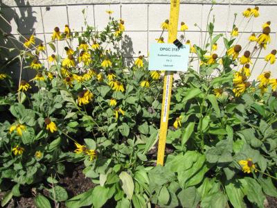 | | 2010 | COLLECTED | 05/26/2010 | Upper West Gulf Coastal Plain. Harrison County. South of Marshall Texas. East on 2625, cross 31, left onto CR 1111, Brad spann road veer right. | 32.47050000, -94.21594400 | 97 | Meadow(Maintained ROW under power lines). Land form: Rolling hills. Land Use: Roadside ROW. Geology: Sandstone. Soil Texture: Sandy. Soil Color: Brown. | Wild material | Erect, clumped, glabrous to 60 cm tall. Flowers numerous, yellow ray florets. | 1897287 | PI 673986 |
| 263 | PI 673989 | TX-11 | Rudbeckia grandiflora (Sweet) C. C. Gmel. ex DC. | Texas, United States | OPGC |  | | 2010 | COLLECTED | 05/26/2010 | Upper West Gulf Coastal Plain. Marion County. Smithland Cuttoff Road approx. 1 mile east of SH 43. | 32.76347200, -94.18152800 | 53 | Roadside ROW/forest edge(tree farm/harvesting area). Land form: Flat. Land Use: Roadside ROW. Geology: Sandstone. Soil Texture: Sandy. Soil Color: Tan. | Wild material | Erect, coarse perennial to 125 cm tall; leaves mostly basal; ray flowers yellow and drooping. | 1897293 | PI 673989 |
| 264 | PI 673991 | TX-23 | Coreopsis lanceolata L. | Texas, United States | OPGC | | | 2010 | COLLECTED | 05/27/2010 | Upper West Gulf Coastal Plain. Jasper County. Roadside ROW along R255. | 31.05984000, -94.00301000 | 135 | Roadside ROW/forest edge. Land form: Rolling hills. Land Use: Roadside ROW. Geology: Sandstone. Soil Texture: Sandy. Soil color: Reddish-orange. | Wild material | Erect, clumped, glabrous to 70 cm tall. Flowers numerous, yellow ray florets. | 1897304 | PI 673991 |
| 265 | PI 673992 | TX-30 | Coreopsis lanceolata L. | Texas, United States | OPGC | | | 2010 | COLLECTED | 05/27/2010 | Upper West Gulf Coastal Plain. Newton County. Roadside approx. 1.5 miles south of 1416 on SH 87. | 30.58986100, -93.79430600 | 27 | Roadside ROW/forest edge. Land form: Flat. Land Use: Roadside ROW. Geology: Sandstone. Soil Texture: Sandy to clay. Soil color: Greyish-brown. | Wild material | Erect, clumped, glabrous to 70 cm tall. Flowers with yellow ray florets, mostly gone to seed. | 1897309 | PI 673992 |
| 266 | PI 653297 | R. argutus HD-2007-070 | Rubus argutus Link | Mississippi, United States | COR | | | 2007 | COLLECTED | 06/09/2007 | Marshall County, northwest of Potts Camp off route 178 onto George Mann Road onto Lake Shore Drive at a drainage ditch in the community of Lake Center. | 34.69310000, -89.36150000 | 120 | Open area in drainage ditch growing on the perimeter road of a lake. Associated Plants: Rhus typhina, Vitis rotundifolia, Pinus taeda, Salix sp., Lonicera japonica, Liquidambar styraciflua and Acer negundo. | Wild material | Kim Hummer, Michael Dossett collection from Mississippi.
| 1730104 | PI 653297 |
| 267 | PI 657239 | V. fuscatum HD-2007-056 | Vaccinium fuscatum Aiton | Alabama, United States | COR | | | 2007 | COLLECTED | 06/07/2007 | Calhoun County, Anniston Museum of Natural History grounds. Woodland trail 0.5 mile from visitors center. Found in the moister areas, such as dried up stream beds. | 33.69411000, -85.82097000 | 230 | Grey loam - from sandstone. South slope 20 percent. Open woods. Associated with: Quercus nigra, Q. stellata, Q. prinus, Vaccinium arboreum, Pinus taeda and Carya. | Wild material | Kim Hummer, Michael Dossett collected from Alabama.
| 1730134 | PI 657239 |
| 268 | PI 649044 | 008 | Echinacea sanguinea Nutt. | Louisiana, United States | NC7 |  | | 1997 | COLLECTED | 08/07/1997 | Kisatchie National Forest, near Leesville, Vernon Parish. Please contact curator for specific site location. | 31.00000000, -93.16666667 | 160 | Upland long-leaf pine. ~70% exposure on level ground. Sandy soil with no stones and fair drainage. | Wild material | Plants were 2-2.5 feet tall in occasional abundance with light pink flowers and some branching. | 1547199 | PI 649044 |
| 269 | NA 89171 | 2025RJLSEUS-04 | Rhododendron catawbiense Michx. | Alabama, United States | NA | | | 2026 | COLLECTED | 09/30/2025 | Scarham Creek: southeast of the Pea Ridge Road bridge, approximately 50-80 meters on the south side of the creek. | 34.32559600, -86.16054600 | 266 | Growing near the base of the slopes above the riparian zone, generally on the exposed geology under very well-drained conditions. The woodlands are primarily deciduous with a few evergreens infrequently mixed. Slope: 15 to 30 percent. Aspect: Northeast. Soil: The primary soil type in the area of this collection is classified as Rockland Series sandstone (Rc). The Rockland series consists of well drained soils formed in loamy colluvium from rotational landslides on slopes of stream valleys and dissections of ground moraines. Saturated hydraulic conductivity is moderate in the upper part of the profile and moderately slow in the lower part. Slopes range from 18 to 70 percent. Some pedons have buried leaves, twigs, and moss. Mass soil movement has left random remnants of soil structure from prior upslope soil development and has buried tree branches, leaves and moss. The upper 0-2 cm of soil contains slightly decomposed organic matter while lower soils layers to a depth of 58 cm are comprised of dark reddish-brown to brown silt loam and are moderately acidic. Below 58 cm the soils are generally dark reddish-brown silt loam and strongly to moderately alkaline. (Source:California Soil Resource Lab/NRCS Official Soil Series Descriptions). Geology: The underlying geology of this area is of Pennsylvanian origin and characterized as Pottsville Formation. It is characterized by light-gray thin to thick-bedded quartzose sandstone and conglomerate containing interbedded dark-gray shale, siltstone, and coal. Mapped on Lookout Mountain, Blount and Chandler Mountains, and Sand Mountain northeast of Blount County, and on the mountains of Jackson, Marshall, and Madison Counties north and west of the TN river. (Source: USGS Alabama Geologic Map Data). | Wild material | Received as R. catawbiense vsr. insularis | 2193305 | NA 89171 |
| 270 | NA 89155 | 2025RJLSEUS-02 | Ilex longipes Chapm. ex Trel. | Alabama, United States | NA | | | 2025 | COLLECTED | 09/30/2025 | Scarham Creek: southeast of the Pea Ridge Road bridge, approximately 50-80 meters on the south side of the creek. | 34.32520700, -86.15967000 | 261 | Plants are growing on relatively steep woodland slopes in shade. The woodlands are primarily deciduous with a few evergreens infrequently mixed. Slope: 15 to 30 percent. Aspect: Northeast. Soil: The primary soil type in the area of this collection is classified as Rockland Series sandstone (Rc). The Rockland series consists of well drained soils formed in loamy colluvium from rotational landslides on slopes of stream valleys and dissections of ground moraines. Saturated hydraulic conductivity is moderate in the upper part of the profile and moderately slow in the lower part. Slopes range from 18 to 70 percent. Some pedons have buried leaves, twigs, and moss. Mass soil movement has left random remnants of soil structure from prior upslope soil development and has buried tree branches, leaves and moss. The upper 0-2 cm of soil contains slightly decomposed organic matter while lower soils layers to a depth of 58 cm are comprised of dark reddish-brown to brown silt loam and are moderately acidic. Below 58 cm the soils are generally dark reddish-brown silt loam and strongly to moderately alkaline. (Source: California Soil Resource Lab/NRCS Official Soil Series Descriptions). Geology: The underlying geology of this area is of Pennsylvanian origin and characterized as Pottsville Formation. It is characterized by light-gray thin to thick-bedded quartzose sandstone and conglomerate containing interbedded dark-gray shale, siltstone, and coal. Mapped on Lookout Mountain, Blount and Chandler Mountains, and Sand Mountain northeast of Blount County, and on the mountains of Jackson, Marshall, and Madison Counties north and west of the TN river. (Source: USGS Alabama Geologic Map Data). | Wild material | | 2193001 | NA 89155 |
| 271 | NA 89156 | 2025RJLSEUS-03 | Euonymus americanus L. | Alabama, United States | NA | | | 2025 | COLLECTED | 09/30/2025 | Scarham Creek: southeast of the Pea Ridge Road bridge, approximately 50-80 meters on the south side of the creek. | 34.32577600, -86.16071000 | 260 | Plants are growing on relatively steep woodland slopes in shade. The woodlands are primarily deciduous with a few evergreens infrequently mixed. Slope: 15 to 30 percent. Aspect: Northeast. Soil: The primary soil type in the area of this collection is classified as Rockland Series sandstone (Rc). The Rockland series consists of well drained soils formed in loamy colluvium from rotational landslides on slopes of stream valleys and dissections of ground moraines. Saturated hydraulic conductivity is moderate in the upper part of the profile and moderately slow in the lower part. Slopes range from 18 to 70 percent. Some pedons have buried leaves, twigs, and moss. Mass soil movement has left random remnants of soil structure from prior upslope soil development and has buried tree branches, leaves and moss. The upper 0-2 cm of soil contains slightly decomposed organic matter while lower soils layers to a depth of 58 cm are comprised of dark reddish-brown to brown silt loam and are moderately acidic. Below 58 cm the soils are generally dark reddish-brown silt loam and strongly to moderately alkaline. (Source: California Soil Resource Lab/NRCS Official Soil Series Descriptions). Geology: The underlying geology of this area is of Pennsylvanian origin and characterized as Pottsville Formation. It is characterized by light-gray thin to thick-bedded quartzose sandstone and conglomerate containing interbedded dark-gray shale, siltstone, and coal. Mapped on Lookout Mountain, Blount and Chandler Mountains, and Sand Mountain northeast of Blount County, and on the mountains of Jackson, Marshall, and Madison Counties north and west of the TN river. (Source: USGS Alabama Geologic Map Data). | Wild material | | 2193002 | NA 89156 |
| 272 | NA 89158 | 2025RJLSEUS-06 | Cornus florida L. | Alabama, United States | NA | | | 2025 | COLLECTED | 10/01/2025 | Coosa Wildlife Management Area: along the edge of gated dirt road on the west side of Coosa County Road 29, 0.3 kilometers north of Hatchet Creek. | 32.86402200, -86.33871400 | 108 | Plants are growing in part sun to shade on dry-mesic slopes above the road cut on the gated dirt road; most likely a road for access for fire control/forest management. The forest is a combination of deciduous and evergreen with evergreens primarily comprised of Pinus taeda. The habitat was quite dry during this time of year. Slope: 5 to 20 percent. Aspect: North. Soils: The primary soil in the area of this collection is classified as Madison-Louisa Series complex, 15 to 30 percent slopes, moderately eroded (MdE2). The Madison Series soils are very deep, well drained soils with medium runoff found on Piedmont uplands in interstream divides, ridges and side slopes. They are comprised of residuum weathered from felsic or intermediate, high-grade metamorphic or igneous rocks high in content of mica. Slopes range from 2 to 60 percent and soil is typically strongly acidic. Louisa Series soils The Louisa Series soils consist of shallow, somewhat excessively drained soils which formed over mica gneiss and schist bedrock. They occur on Piedmont uplands. Slopes are 6 to 80 percent. This soil is moderately acid. (Source: California Soil Resource Lab/NRCS Official Soil Series Descriptions). Geology: The underlying geology of this area is of Precambrian to Paleozoic origin and characterized as Hatchet Creek Group; Pinchoulee Gneiss Formation. It is characterized by medium to fine-grained migmatitic, locally garnetiferous biotite-feldspar gneiss, commonly saturated with granitic pods. (Source: USGS Alabama Geologic Map Data). | Wild material | | 2193004 | NA 89158 |
| 273 | NA 89115 | TLM25-04a | Hamamelis ovalis S. W. Leonard | Texas, United States | NA | | | 2025 | COLLECTED | 07/10/2025 | State Highway 87 approximately 3.25 kilometers north of the crossroad junction with Texas Recreational Road 255 (RE 255); plants were growing in the narrow buffer woods along the east side of the highway. | 31.12051300, -93.72628100 | 138 | The habitat is an upland mixed coniferous and deciduous woodlands in part to full shade and dry conditions, often under drought stress. Plants seem to always occur on the top of dry ridges or well-drained slopes. Slope: 0 to 1 percent. Aspect: N/A. Soils: The soils of this collection area are classified as Tehran-Letney Association, hilly (TLE) soils. The Tehran Series (55%) consists of deep, somewhat excessively drained, moderately rapidly permeable soils on uplands. They formed in thick loamy and sandy sediments on the Western Coastal Plain. These soils are on gently sloping to moderately steep uplands with slopes ranging from 1 to 20 percent. The Letney Series (30%) consists of deep, well drained, moderately rapidly permeable, upland soils. They formed in thick sandy and loamy sediments of the coastal plains. These soils are on gently sloping to moderately steep uplands with slopes ranging from 1 to 20 percent. Soil pH ranges from 4.5 to 6.0. The minor soil components include Doucette Series (10%) and Boykin Series (5%) soils. (Source: California Soil Resource Lab/NRCS Official Soil Series Descriptions). Geology: The underlying geology of this area is of Oligocene origin and characterized as Catahoula Formation. This formation is extensive and deep in Texas, up to 185 meters thick. In the area of the collection the Catahoula Formation is primarily mudstone and sand. The upper 90-150 meters is mudstone that is tuffaceous, and sandy; also, occasionally, with some bentonitic clay. (Source: USGS Texas Geologic Map Data). | Wild material | | 2191654 | NA 89115 |
| 274 | NA 88930 | 24Flam16 | Rhododendron canescens (Michx.) Sweet | Georgia, United States | NA | | | 2025 | COLLECTED | 09/10/2024 | DeKalb County: Stone Mountain: Stone Mountain Park: slope near Robert E. Lee Boulevard. | 33.80238000, -84.15508000 | 286 | Dry, shady slope. Growing in 3/4 shade. Slope: 30 to 45 degrees. Aspect: West-southwest. | Wild material | Note: Seeds from three different plants collected at the same spot were bulked together in this accession; the lowest field collection number (24Flam16) has been chosen as the primary for this record. It appears from the notes that the identity is slightly uncertain; possibly not pure R. canescens. | 2172813 | NA 88930 |
| 275 | NA 88933 | 24Flam40 | Agarista populifolia (Lam.) Judd | South Carolina, United States | NA | | | 2025 | COLLECTED | 09/12/2025 | Robertville, SC: Gillison Branch Road (plants on both sides of road). | 32.58673000, -81.19300000 | 31 | Shady swamp forest with road running between Agarista population. Agarista was the predominant plant throughout. Soggy but solid ground, especially on northern side of road. Growing in 3/4 shade. Slope: Generally flat. | Wild material | Note: Two field collections, 24Flam40 and 24Flam41, were combined together in this USNA accession, with the former identifier being used as the primary one. | 2172816 | NA 88933 |
| 276 | NA 88747 | TXWL2025-038 | Ilex opaca Aiton | Texas, United States | NA | | | 2025 | COLLECTED | 01/23/2025 | Milam, Texas: On flat road, private land. | 31.43288000, -93.88208000 | | Upland shortleaf pine stand with sandy loam; closed canopy. | Wild material | | 2171021 | NA 88747 |
| 277 | NA 88981 | TXWL2025-031 | Ilex opaca Aiton | Texas, United States | NA | | | 2025 | COLLECTED | 01/07/2025 | South of Jericho community. | 31.67015000, -94.25641000 | | Western sandy lands; small grove of Ilex opaca in upland position above a baygall. Bare ground cover with Ilex opaca regeneration. Adjacent to a loblolly pine plantation and a new longleaf pine plantation. | Wild material | | 2170965 | NA 88981 |
| 278 | NA 88982 | TXWL2025-032 | Ilex opaca Aiton | Texas, United States | NA | | | 2025 | COLLECTED | 01/07/2025 | South of Jericho community. | 31.66973000, -94.25613000 | | Western sandy lands; edge of small grove of Ilex opaca with sun exposure in upland position above a baygall. Bare ground cover with Ilex opaca regeneration. Adjacent to a new longleaf pine plantation located on fireline. | Wild material | | 2170966 | NA 88982 |
| 279 | NA 88983 | TXWL2025-033 | Ilex opaca Aiton | Texas, United States | NA | | | 2025 | COLLECTED | 01/12/2025 | Adjacent to Toledo Bend reservoir in Huxley Bay community, eastern Shelby County. | 31.77133000, -93.85094000 | | Low area with heavy duff near reservoir. | Wild material | | 2170967 | NA 88983 |
| 280 | NA 88987 | TXWL2025-037 | Ilex opaca Aiton | Texas, United States | NA | | | 2025 | COLLECTED | 01/13/2025 | Fairmount Township: Sabine National Forest C-139: Foxhunters Hill. | 31.18365000, -93.72211000 | | Baygall below a longleaf pine stand. | Wild material | | 2170971 | NA 88987 |
| 281 | NA 88580 | 2024RJLFL-009 | Ilex myrtifolia Walter | Florida, United States | NA | | | 2024 | COLLECTED | 11/13/2024 | Woodlands on the north side of Fisher Old Mill Road about 0.10 kilometers west of intersection with DOF Y12. | 30.62693800, -86.83962200 | 6 | Mixed evergreen and deciduous moist to wet forest in part shade to full sun. From the associated taxa, this site can be quite wet during the growing season; however, it was dry during this collection time; likely due to extended drought. Slope: 0 percent. Aspect: South. | Wild material | | 2169917 | NA 88580 |
| 282 | NA 88479 | TXWL2024-029 | Ilex longipes Chapm. ex Trel. | Texas, United States | NA | | | 2024 | COLLECTED | 11/20/2024 | Little Cow Creek. | 31.06221000, -93.79603000 | | Upland position above perennial creek. | Wild material | | 2169906 | NA 88479 |
| 283 | NA 87842 | TRX241117-08SC | Ilex opaca Aiton | South Carolina, United States | NA | | | 2024 | COLLECTED | 11/17/2024 | Francis Marion National Forest. | 33.15167000, -79.60253000 | 31 | | Wild material | | 2169895 | NA 87842 |
| 284 | NA 87845 | TRX241119-01GA | Ilex coriacea (Pursh) Chapm. | Georgia, United States | NA | | | 2024 | COLLECTED | 11/19/2024 | St. Simons Island: Guale Preserve. | 31.21861000, -81.36872000 | 6 | | Wild material | | 2169898 | NA 87845 |
| 285 | NA 89088 | 2024RM-TK-001 | Viburnum acerifolium L. | Alabama, United States | NA | | | 2024 | COLLECTED | 09/19/2024 | Haines Island Park. Follow Ferry Road to the top of the hill entering the park where a picnic shelter is located. Plants are growing along trails to the north of the picnic shelter. | 31.72132026, -87.46408910 | 81 | Plants are growing from part-sun to full shade in the understory of a mixed deciduous and coniferous forest on very dry upland habitat. Slope: 10 to 20 percent. Aspect: North. Geology: The underlying geology of this area is probably of Eocene age and characterized as the Claiborne Group: Tallahatta Formation. It is comprised of white to very light-greenish-gray thin-bedded to massive siliceous claystone; interbedded with thin layers of fossiliferous clay, sandy clay, and glauconitic sand and sandstone. White to light-greenish-gray fine to coarse sand and fine gravel occur at the base of the formation in southwest Alabama (Meridian Sand Member). (Source: USGS Alabama Geologic Map Data). Soils: The area of this occurrence is characterized as Arundel Series Loam, 8 to 35 percent slopes (ArF). The Arundel series consists of moderately deep, well drained, very slowly permeable soils on dissected uplands of the Southern Coastal Plain Major Land Resource Area (MLRA 133A). They formed in marine deposits consisting of acid clays underlain by horizontally bedded sandstone, buhrstone and siltstone. Slopes range from 2 to 60 percent. (Source: California Soil Resource Lab/NRCS Official Soil Series Descriptions). EPA Ecoregion (Level III): Southeastern Plains (65). EPA Ecoregion (Level IV): Buhrstone/Lime Hills (65q). | Wild material | | 2169052 | NA 89088 |
| 286 | NA 89089 | 2024RM-TK-002 | Viburnum acerifolium L. | Alabama, United States | NA | | | 2024 | COLLECTED | 09/19/2024 | Woodland slopes around and below the hilltop parking area leading down to the Silver Creek Lake Campground off of Silver Creek Lake Road. | 31.66612294, -87.57569860 | 49 | Plants are growing in shade of upland dry mesic, mature mixed deciduous and evergreen woodland. Generally, the overstory is thinner and there is less leaf litter cover, making the surface soil conditions drier. Slope: 5 to 10 percent. Aspect: Southeast. Geology: The underlying geology of this area is Claiborne Group, Tallahatta Formation, of Eocene origin, with white to very light-greenish-gray thin-bedded to massive siliceous claystone; interbedded with thin layers of fossiliferous clay, sandy clay, and glauconitic sand and sandstone. (Source: USGS Alabama Geologic Map Data). Soils: The primary soil types in the collection area are classified as Arundel-Cantuche Complex soils (15 to 35 percent slopes). The Arundel Series consists of moderately deep, well drained, very slowly permeable soils on dissected uplands of the Southern Coastal Plain. They formed in marine deposits consisting of acid clays underlain by horizontally bedded sandstone, buhrstone and siltstone. These soils are strongly acid. Slopes range from 2 to 60 percent. The Cantuche Series consists of shallow, well drained, moderately permeable soils that formed over horizontally bedded claystone. These soils are on narrow ridgetops and narrow benches on steep side-slopes of dissected landscapes in the Coastal Plain. They are strongly acid. Slopes range from 2 to 35 percent. (Source: California Soil Resource Lab/NRCS Official Soil Series Descriptions). EPA Ecoregion (Level III): Southeastern Plains (65). EPA Ecoregion (Level IV): Buhrstone/Lime Hills (65q). | Wild material | | 2169053 | NA 89089 |
| 287 | NA 89090 | 2024RM-TK-003 | Ilex longipes Chapm. ex Trel. | Alabama, United States | NA | | | 2024 | COLLECTED | 09/19/2024 | Woodland slopes around and below the hilltop parking area leading down to the Silver Creek Lake Campground off of Silver Creek Lake Road. | 31.66612294, -87.57569860 | 39 | Plants are growing in part-shade to shade of a moist mesic deciduous and evergreen woodland on dry, well-drained soil to an area 1-2 meters above a small seasonally spring-fed creek at 31.664428°, -87.574614°. Slope: 5 to 10 percent. Aspect: Southeast. Geology: The underlying geology of this area is Claiborne Group, Tallahatta Formation, of Eocene origin, with white to very light-greenish-gray thin-bedded to massive siliceous claystone; interbedded with thin layers of fossiliferous clay, sandy clay, and glauconitic sand and sandstone. (Source: USGS Alabama Geologic Map Data). Soils: The primary soil types in the collection area are classified as Arundel-Cantuche Complex soils (15 to 35 percent slopes). The Arundel Series consists of moderately deep, well drained, very slowly permeable soils on dissected uplands of the Southern Coastal Plain. They formed in marine deposits consisting of acid clays underlain by horizontally bedded sandstone, buhrstone and siltstone. These soils are strongly acid. Slopes range from 2 to 60 percent. The Cantuche Series consists of shallow, well drained, moderately permeable soils that formed over horizontally bedded claystone. These soils are on narrow ridgetops and narrow benches on steep side-slopes of dissected landscapes in the Coastal Plain. They are strongly acid. Slopes range from 2 to 35 percent. (Source: California Soil Resource Lab/NRCS Official Soil Series Descriptions). EPA Ecoregion (Level III): Southeastern Plains (65). EPA Ecoregion (Level IV): Buhrstone/Lime Hills (65q). | Wild material | | 2169054 | NA 89090 |
| 288 | NA 88838 | RJL-RM2023FLAL-012 | Ilex opaca Aiton | Florida, United States | NA | | | 2023 | COLLECTED | 12/08/2023 | North side of Sid Hayes Road approximately 65 m southeast of the junction with Watson Road. | 30.83277400, -87.24324500 | 32 | Growing in shade, part shade and light shade in dry mesic to moist, occasionally wet, habitats along the edge of the road and in the woodland interior. This species is remarkably adaptable. The only drawback to the range of habitats is that in deep shade, very few fruit can be found, presumably because there is far less flower production and/or fewer pollinators. Slope: 0 to 3 percent. Aspect: South. The underlying geology of this area is the Citronelle Formation of Pliocene origin and consists of gray to orange, often mottled, unconsolidated to poorly consolidated, very fine to very coarse, poorly sorted, clean to clayey sands. It contains significant amounts of clay, silt and gravel which may occur as beds and lenses and may vary considerably over short distances. Limonite nodules and limonite-cemented beds are common. (Source: USGS Florida Geologic Map Data.) The surface soil profile of this area is Dothan Series fine sandy loam soils (5 to 8 percent slopes). The Dothan Series consists of very deep, well drained soils that formed in thick beds of unconsolidated, medium to fine-textured marine sediments. Dothan soils are on interfluves. The surface 0-33 cm is characterized by sandy-loam, well-drained soils that are strongly acid. From 33-200 cm they are characterized by sandy clay loam soils that are more moisture retentive and strongly acid. (Source: NRCS Web Soil Survey.) | Wild material | | 2165668 | NA 88838 |
| 289 | NA 88840 | RJL-RM2023FLAL-014 | Rhododendron viscosum (L.) Torr. | Florida, United States | NA | | | 2023 | COLLECTED | 12/11/2023 | Property of Floyd Griffith off View Drive on the southwest side of McCormick Lake. | 30.63247000, -85.33718200 | 56 | Plants are growing primarily in part shade a few meters above the lake, generally in areas that appear dry, but clearly are associated with hillside seeps. While much of the area has been cultivated, the remnant native flora are largely broadleaved evergreen shrub and deciduous shrub and tree species. Slope: 10 to 15 percent. Aspect: Northeast. The underlying geology of this area is the Citronelle Formation of Pliocene origin and consists of gray to orange, often mottled, unconsolidated to poorly consolidated, very fine to very coarse, poorly sorted, clean to clayey sands. It contains significant amounts of clay, silt and gravel which may occur as beds and lenses and may vary considerably over short distances. Limonite nodules and limonite-cemented beds are common. (Source: USGS Florida Geologic Map Data.) The surface soil profile of this area is primarily Pamlico-Pantego-Rutlege Association. The Pamlico series consists of very poorly drained soils that formed in decomposed organic material underlain by dominantly sandy sediment. The soils are on nearly level flood plains, bays, and depressions of the Coastal Plain. Slopes are less than 1 percent. Pamlico soils have 0.4-1.3 meters of organic material over dominantly sandy sediments. Reaction is extremely in the organic layers and ranges from extremely acid to strongly acid in the underlying mineral layers. The Pantego series consists of very deep, very poorly drained, moderately permeable soils that formed in thick loamy sediments on the Southern Coastal Plain and Atlantic Coast Flatwoods. Slopes are less than 2 percent. This soil is strongly acid. The Rutlege series comprises very deep, very poorly drained persistently wet soils on flats, depressions and floodplains where shallow ponding is common. They are of marine or fluvial sediment origin. Thickness of these loamy sandy soils is greater than 1.5 meters and a reaction from extremely acid to strongly acid. (Source: NRCS Web Soil Survey.) | Wild material | | 2165670 | NA 88840 |
| 290 | NA 88841 | RJL-RM2023FLAL-015 | Pinckneya bracteata (W. Bartram) Raf. | Florida, United States | NA | | | 2023 | COLLECTED | 12/11/2023 | West side of Marville Drive on the edge of the woodlands just a few hundred feet south of Fairway Drive. | 30.60665300, -85.32572200 | 79 | Plants are growing on the edge of a wetland acid habitat in the transitional zone between the obligate and facultative zones. They are growing in part-shade to shade with lower woody competition due to the moist conditions. Slope: N/A. Aspect: N/A. The underlying geology of this area is the Citronelle Formation of Pliocene origin and consists of gray to orange, often mottled, unconsolidated to poorly consolidated, very fine to very coarse, poorly sorted, clean to clayey sands. It contains significant amounts of clay, silt and gravel which may occur as beds and lenses and may vary considerably over short distances. Limonite nodules and limonite-cemented beds are common. (Source: USGS Florida Geologic Map Data.) The surface soil profile of this area is primarily Pamlico-Pantego-Rutlege Association. The Pamlico series consists of very poorly drained soils that formed in decomposed organic material underlain by dominantly sandy sediment. The soils are on nearly level flood plains, bays, and depressions of the Coastal Plain. Slopes are less than 1 percent. Pamlico soils have 0.4-1.3 meters of organic material over dominantly sandy sediments. Reaction is extremely in the organic layers and ranges from extremely acid to strongly acid in the underlying mineral layers. The Pantego series consists of very deep, very poorly drained, moderately permeable soils that formed in thick loamy sediments on the Southern Coastal Plain and Atlantic Coast Flatwoods. Slopes are less than 2 percent. This soil is strongly acid. The Rutlege series comprises very deep, very poorly drained persistently wet soils on flats, depressions and floodplains where shallow ponding is common. They are of marine or fluvial sediment origin. Thickness of these loamy sandy soils is greater than 1.5 meters and a reaction from extremely acid to strongly acid. (Source: NRCS Web Soil Survey.) | Wild material | | 2165671 | NA 88841 |
| 291 | NA 88842 | RJL-RM2023FLAL-016 | Pinckneya bracteata (W. Bartram) Raf. | Florida, United States | NA | | | 2023 | COLLECTED | 12/11/2023 | West side of Scott Road in woodlands approximately 0.13 kilometers north of where the road crosses Ecofina Creek. As of 2023, this road appears permanently closed from previous hurricane damage. | 30.55633300, -85.43520000 | 38 | Plants are growing in the understory of a mixed evergreen and deciduous bottomland forest associated with the Ecofina Creek. Plans are growing mostly on hummocks in a very wet, acidic wetland habitat. Slope: N/A. Aspect: N/A. The underlying geology of this area is the Alum Bluff Group of Miocene origin. It includes the Chipola Formation, Oak Grove Sand, Shoal River Formation, Choctawhatchee Formation and the Jackson Bluff Formation. The formations included in this group are generally defined on the basis of their molluscan faunas and stratigraphic position. Puri (1953) described sediment facies as they relate to the formations of the Alum Bluff Group. These sediments are lithologically distinct as a group, not as individual units. The Alum Bluff Group crops out or is beneath a thin overburden in the western panhandle from river valleys in Okaloosa County eastward to western Jackson County. The Alum Bluff Group consists of clays, sands and shell beds which may vary from fossiliferous, sandy clays to unfossiliferous sands and clays and occasional carbonate beds. Mica is a common constituent and glauconite and phosphate occur sporadically. Induration varies from essentially nonindurated in sands to well indurated in carbonate lenses. Colors range from cream to olive gray with mottled reddish brown in weathered sections. Sand grain size varies from very fine to very coarse with sporadic occurrences of gravel. These sediments generally have low permeabilities and are part of the intermediate confining unit/aquifer system. (Source: USGS Florida Geologic Map Data.) The surface soil profile of this area is primarily Pamlico-Pantego-Rutlege Association. The Pamlico series consists of very poorly drained soils that formed in decomposed organic material underlain by dominantly sandy sediment. The soils are on nearly level flood plains, bays, and depressions of the Coastal Plain. Slopes are less than 1 percent. Pamlico soils have 0.4-1.3 meters of organic material over dominantly sandy sediments. Reaction is extremely in the organic layers and ranges from extremely acid to strongly acid in the underlying mineral layers. The Pantego series consists of very deep, very poorly drained, moderately permeable soils that formed in thick loamy sediments on the Southern Coastal Plain and Atlantic Coast Flatwoods. Slopes are less than 2 percent. This soil is strongly acid. The Rutlege series comprises very deep, very poorly drained persistently wet soils on flats, depressions and floodplains where shallow ponding is common. They are of marine or fluvial sediment origin. Thickness of these loamy sandy soils is greater than 1.5 meters and a reaction from extremely acid to strongly acid. (Source: NRCS Web Soil Survey.) | Wild material | | 2165672 | NA 88842 |
| 292 | NA 88843 | RJL-RM2023FLAL-017 | Rhododendron austrinum (Small) Rehder | Florida, United States | NA | | | 2023 | COLLECTED | 12/11/2023 | Holmes Creek at Live Oak Landing: plants found on the low bluff along the south side of Holmes Creek accessed by foot from a parking lot on Live Oak Landing Road that dead ends into the creek. | 30.59043500, -85.83899800 | 7 | Plants are growing in part shade to shade on the top and slope of the low bluff overlooking Holmes Creek in a mixed deciduous and evergreen forest. The dry mesic habitat has relatively low competition and is quite acidic. Slope: 0 to 45 percent. Aspect: Northwest. The underlying geology of this area is classified as Alluvium, of Pleistocene/Holocene origin and consists of undifferentiated Quaternary sediments of varying thickness including siliciclastics, organics and freshwater carbonates. The siliciclastics are light gray, tan, brown to black, unconsolidated to poorly consolidated, clean to clayey, silty, unfossiliferous, variably organic-bearing sands to blue green to olive green, poorly to moderately consolidated, sandy, silty clays. Organics occur as plant debris, roots, disseminated organic matrix and beds of peat. Freshwater carbonates, often referred to as marls in the literature, are scattered. (Source: USGS Florida Geologic Map Data.) The surface soil profile of this area is primarily Nankin-Cowarts-Lakeland Complex. The Nankin Series consists of very deep, well drained, moderately slowly permeable soils on uplands of the Coastal Plain. They formed in stratified loamy and clayey marine sediments. Slopes range from 0 to 60 percent. Soils are comprised of sandy loam in the upper 25 cm to sandy clay loam and sandy clay in lower strata to about 1.7 meters deep; these soils are strongly acid. The Cowarts Series consists of very deep, moderately well and well drained soils on ridge tops and side slopes on uplands of the Coastal Plain Major Land Resource Area. They formed in loamy marine sediments. Slopes range from 1 to 60 percent. The Lakeland series consists of very deep, excessively drained, rapid to very rapidly permeable soils on uplands. They formed in thick beds of eolian or marine and/or fluvio-marine sands. Thickness of the sand exceeds 2 meters. Silt plus clay in the upper meter ranges from 5-10 percent. Reaction ranges from very strongly acid to moderately acid throughout. (Source: NRCS Web Soil Survey.) | Wild material | | 2165673 | NA 88843 |
| 293 | NA 88844 | RJL-RM2023FLAL-018 | Clethra alnifolia L. | Florida, United States | NA | | | 2023 | COLLECTED | 12/13/2023 | Yellow River Water Management Area, accessed off of Old River Road by vehicle on an unmaintained sand road for approximately 1.68 kilometers. Upon reaching the destination, plants are accessed by foot along unmaintained trail to the east. | 30.83495500, -86.62005400 | 27 | Plants are growing primarily in part shade as understory shrubs in mixed evergreen and deciduous, moist to wet, acidic woodlands. Plants form large colonies and appear to have been subjected to prescribed fire in recent years. Slope: 10 to 15 percent. Aspect: Northeast. The underlying geology of this area is the Citronelle Formation of Pliocene origin and consists of gray to orange, often mottled, unconsolidated to poorly consolidated, very fine to very coarse, poorly sorted, clean to clayey sands. It contains significant amounts of clay, silt and gravel which may occur as beds and lenses and may vary considerably over short distances. Limonite nodules and limonite-cemented beds are common. (Source: USGS Florida Geologic Map Data.) The soil profile for this area is classified as the Bonifay Soil Series. Bonifay soil consists of very deep, well drained, moderately slowly permeable soils on ridges and side slopes in the Southern Coastal Plain. They formed in thick beds of sandy and loamy marine sediments. Solum thickness ranges from 1.5-2.0 m. Soil reaction ranges from very strongly acid to moderately acid throughout, except where the surface has been limed. Ironstone pebbles, 2 to 15 mm in size, range from 0 to 5 percent, by volume. Depth to the plinthic horizon ranges from 1.1-1.7 m. Some horizons contain up to 25 percent plinthite by volume. (Source: NRCS Web Soil Survey.) | Wild material | | 2165674 | NA 88844 |
| 294 | WLP 3377 | TXWL2023-024 | Viburnum dentatum L. | Texas, United States | NA | | | 2023 | COLLECTED | 12/13/2023 | Roadside between Big Cow Creek and Hardy Cemetery. | 31.03548900, -93.85086800 | | Roadside; mesic, mixed hardwood/pine forest. | Wild material | | 2165656 | WLP 3377 |
| 295 | NA 88812 | TXWL2023-018 | Ilex ambigua Torr. | Texas, United States | NA | | | 2023 | COLLECTED | 12/05/2023 | Davy Crockett National Forest: Forest Service Road 526 roadside. | 31.49017400, -95.22343300 | | Roadside. Shortleaf mixed upland hardwood forest; dry-mesic. | Wild material | | 2165615 | NA 88812 |
| 296 | NA 88814 | TXWL2023-021 | Ilex ambigua Torr. | Texas, United States | NA | | | 2023 | COLLECTED | 12/09/2023 | Roadside between Big Cow Creek and Hardy Cemetery. | 31.03548900, -93.85086800 | | Roadside; mesic, mixed hardwood/pine forest. | Wild material | | 2165618 | NA 88814 |
| 297 | NA 88815 | TXWL2023-022 | Ilex opaca Aiton | Texas, United States | NA | | | 2023 | COLLECTED | 12/10/2023 | Angelina National Forest: Upland Island Wilderness Area: Neches River bottom. | 31.03919400, -94.37937900 | | Bottomland hardwood forest. | Wild material | | 2165619 | NA 88815 |
| 298 | NA 88816 | TXWL2023-023 | Ilex decidua Walter | Texas, United States | NA | | | 2023 | COLLECTED | 12/10/2023 | Angelina National Forest: Upland Island Wilderness Area: Neches River bottom. | 31.03478500, -94.38286600 | | Bottomland hardwood forest. | Wild material | | 2165620 | NA 88816 |
| 299 | NA 88800 | TXWL2023-015 | Ilex longipes Chapm. ex Trel. | Texas, United States | NA | | | 2023 | COLLECTED | 11/15/2023 | Sabine National Forest: Compartment 65 along County Road 131 near White Rock, Texas. | 31.55793500, -94.01980900 | | Upland; mixed hardwood and pine; sandy soil; rocky outcrops. | Wild material | | 2159157 | NA 88800 |
| 300 | WLP 3343 | TXWL2023-014 | Croton michauxii G. L. Webster | Texas, United States | NA | | | 2023 | COLLECTED | 11/07/2023 | Angelina National Forest: Compartment 84 Black Branch Area. | 31.03849000, -94.18679000 | | Glade area on the Catahould/Fleming formation. | Wild material | | 2159156 | WLP 3343 |
| 301 | NA 88696 | RJL2023NCSC-001 | Rhododendron catawbiense Michx. | North Carolina, United States | NA | | | 2023 | COLLECTED | 11/12/2023 | Duke Forest property along New Hope Creek. The collection site is accesses by foot along trails. | 35.98317700, -79.01856200 | 103 | Plants growing in shade to part-shade of an upland very dry woodland habitat that is mostly deciduous. The site is steeply sloped underlain by rocky outcrop. Slope: 15 to 25 percent. Aspect: Northwest. The underlying geology of this area is of Cambrian/Late Proterozoic origin and characterized as a Metamorphosed Granitic Rock. It is megacrystic and well foliated; locally contains hornblende. Chapel Hill, Chatham, Farrington, Meadow Flats, Mt. Moriah, Parks Crossroads plutons, and Roxboro and Vance County suites. (Source: USGS North Carolina Geologic Map Data.) The primary soil type in the collection area is classified as Wedowee sandy loam, 15 to 25 percent slopes. Wedowee Series consists of very deep, well drained, moderately permeable soils that formed in residuum weathered from felsic igneous and metamorphic rocks of the Piedmont uplands. These soils are on narrow ridges and on side slopes of uplands. Slopes are dominantly 6 to 25 percent but ranges from 0 to 60 percent. The strata range from dark brown and brownish yellow to strong brown. They are mostly sandy loam; moderate fine granular structure; very friable; strongly acid. (Source: NRCS Web Soil Survey.) | Wild material | | 2159124 | NA 88696 |
| 302 | NA 88697 | RJL2023NCSC-002 | Ilex amelanchier M. A. Curtis ex Chapm. | North Carolina, United States | NA | | | 2023 | COLLECTED | 11/12/2023 | Goose Pond Bay (Nature Conservancy-owned site): wetlands on the south side of McNeil Road approximately 0.64 kilometers west of junction with McIntosh Road. | 34.88254100, -79.09915700 | 60 | Plants are growing in part-shade to sun of a Carolina Bay habitat with seasonally moist to wet, acidic conditions. Slope: N/A. Aspect: N/A. The underlying geology of this area is of Cretaceous origin and characterized as Black Creek Formation. The formation is comprised of clay that is gray to black and lignitic. It contains thin beds and laminae of fine-grained micaceous sand and thick lenses of cross-bedded sand. This formation has glauconitic, fossiliferous clayey sand lenses in the upper part. (Source: USGS North Carolina Geologic Map Data.) The primary soil type in the collection area is classified as McColl loam soil. The McColl Series consists of poorly drained, slowly permeable soils that are shallow or moderately deep to a fragipan and very deep to bedrock. They formed in loamy sediments in oval depressions on the Coastal Plain. The soils are nearly level or concave. Runoff is frequently ponded. Slopes are less than 2 percent. These soils are strongly acid. (Source: NRCS Web Soil Survey.) | Wild material | | 2159125 | NA 88697 |
| 303 | NA 88698 | RJL2023NCSC-003 | Ilex laevigata (Pursh) A. Gray | North Carolina, United States | NA | | | 2023 | COLLECTED | 11/13/2023 | Sandhills Game Land: north side of Pulpwood Road approximately 0.11 km southwest of the junction with Tyner Road. | 34.95939500, -79.48676300 | 114 | Plants growing in shade to part-shade of a spring fed wetland that is a mixed evergreen and deciduous woodland habitat. Slope: 3 to 10 percent. Aspect: Northeast. The underlying geology of this area is of Tertiary origin and characterized as Pinehurst Formation. It is comprised of sand that is medium- to coarse-grained, cross-bedding and rhythmic bands of clayey sand common, unconsolidated. (Source: USGS North Carolina Geologic Map Data.) The primary soil type in the area of this collection is classified as Pelion loamy sand, 6 to 10 percent slopes. Pelion Series soils are very deep, moderately well-drained soils with moderately slow to slow permeability. The upper 30 cm of the strata is sandy loam to sandy clay loam ranging from grayish brown to reddish yellow. This stratum has a weak fine granular structure and is very friable. It contains many fine roots and is moderately acid. Deeper strata to 2 m range from yellow to yellowish red sandy clay, often with masses of oxidized iron and few fine prominent light gray iron depletions; they are strongly acid. (Source: NRCS Web Soil Survey.) | Wild material | | 2159126 | NA 88698 |
| 304 | NA 88699 | RJL2023NCSC-004 | Lyonia ligustrina (L.) DC. | North Carolina, United States | NA | | | 2023 | COLLECTED | 11/13/2023 | Sandhills Game Land: north side of Pulpwood Road approximately 0.11 km southwest of the junction with Tyner Road. | 34.95949000, -79.48665600 | 107 | Plants growing in part-shade to sun on the moist margins of a spring fed wetland that is a mixed evergreen and deciduous woodland habitat. The underlying soils are moist even during dry periods due to seepage from the wetland. Slope: 3 to 10 percent. Aspect: Northeast. The underlying geology of this area is of Tertiary origin and characterized as Pinehurst Formation. It is comprised of sand that is medium- to coarse-grained, cross-bedding and rhythmic bands of clayey sand common, unconsolidated. (Source: USGS North Carolina Geologic Map Data.) The primary soil type in the area of this collection is classified as Pelion loamy sand, 6 to 10 percent slopes. Pelion Series soils are very deep, moderately well-drained soils with moderately slow to slow permeability. The upper 30 cm of the strata is sandy loam to sandy clay loam ranging from grayish brown to reddish yellow. This stratum has a weak fine granular structure and is very friable. It contains many fine roots and is moderately acid. Deeper strata to 2 m range from yellow to yellowish red sandy clay, often with masses of oxidized iron and few fine prominent light gray iron depletions; they are strongly acid. (Source: NRCS Web Soil Survey.) | Wild material | | 2159127 | NA 88699 |
| 305 | NA 88700 | RJL2023NCSC-005 | Clethra alnifolia L. | North Carolina, United States | NA | | | 2023 | COLLECTED | 11/13/2023 | Sandhills Game Land: north side of Pulpwood Road approximately 0.11 km southwest of the junction with Tyner Road. | 34.96008500, -79.48751100 | 108 | Plants growing in shade to part-shade as well as sun (when moisture is abundant) of a spring fed wetland that is comprised of a mixed evergreen and deciduous woodland habitat. Slope: 3 to 10 percent. Aspect: Various. : The underlying geology of this area is of Cretaceous origin and characterized as Middendorf Formation. It is characterized by sand, sandstone, and mudstone, gray to pale gray with an orange cast, mottled; clay balls and iron-cemented concretions common, beds laterally discontinuous, cross-bedding common. (Source: USGS North Carolina Geologic Map Data.) The primary soil type in the area of this collection is classified as Pelion loamy sand, 6 to 10 percent slopes. Pelion Series soils are very deep, moderately well-drained soils with moderately slow to slow permeability. The upper 30 cm of the strata is sandy loam to sandy clay loam ranging from grayish brown to reddish yellow. This stratum has a weak fine granular structure and is very friable. It contains many fine roots and is moderately acid. Deeper strata to 2 m range from yellow to yellowish red sandy clay, often with masses of oxidized iron and few fine prominent light gray iron depletions; they are strongly acid. (Source: NRCS Web Soil Survey.) | Wild material | | 2159128 | NA 88700 |
| 306 | NA 88701 | RJL2023NCSC-006 | Zenobia pulverulenta (W. Bartram ex Willd.) Pollard | North Carolina, United States | NA | | | 2023 | COLLECTED | 11/13/2023 | Sandhills Game Land: north side of Pulpwood Road approximately 0.11 km southwest of the junction with Tyner Road. | 34.96066900, -79.48735300 | 111 | Plants growing in moist-mesic to seasonally saturated soils in part-shade of a spring fed wetland that is a mixed evergreen and deciduous woodland habitat. Slope: 0 to 5 percent. Aspect: Northeast. The underlying geology of this area is of Tertiary origin and characterized as Pinehurst Formation. It is comprised of sand that is medium- to coarse-grained, cross-bedding and rhythmic bands of clayey sand common, unconsolidated. (Source: USGS North Carolina Geologic Map Data.) The primary soil type in the area of this collection is classified as Pelion loamy sand, 6 to 10 percent slopes. Pelion Series soils are very deep, moderately well-drained soils with moderately slow to slow permeability. The upper 30 cm of the strata is sandy loam to sandy clay loam ranging from grayish brown to reddish yellow. This stratum has a weak fine granular structure and is very friable. It contains many fine roots and is moderately acid. Deeper strata to 2 m range from yellow to yellowish red sandy clay, often with masses of oxidized iron and few fine prominent light gray iron depletions; they are strongly acid. (Source: NRCS Web Soil Survey.) | Wild material | | 2159129 | NA 88701 |
| 307 | NA 88702 | RJL2023NCSC-007 | Rhododendron viscosum (L.) Torr. | North Carolina, United States | NA | | | 2023 | COLLECTED | 11/13/2023 | Sandhills Game Land: north side of Pulpwood Road approximately 0.11 km southwest of the junction with Tyner Road. | 34.96080300, -79.48730200 | 113 | Plants growing in moist-mesic to seasonally saturated soils in shade to part-shade of a spring fed wetland that is a mixed evergreen and deciduous woodland habitat. Prescribed fires have burned a portion of the wetland edge where plants are resprouting vigorously. Slope: 0 to 5 percent. Aspect: Norhteast. The underlying geology of this area is of Tertiary origin and characterized as Pinehurst Formation. It is comprised of sand that is medium- to coarse-grained, cross-bedding and rhythmic bands of clayey sand common, unconsolidated. (Source: USGS North Carolina Geologic Map Data.) The primary soil type in the area of this collection is classified as Pelion loamy sand, 6 to 10 percent slopes. Pelion Series soils are very deep, moderately well-drained soils with moderately slow to slow permeability. The upper 30 cm of the strata is sandy loam to sandy clay loam ranging from grayish brown to reddish yellow. This stratum has a weak fine granular structure and is very friable. It contains many fine roots and is moderately acid. Deeper strata to 2 m range from yellow to yellowish red sandy clay, often with masses of oxidized iron and few fine prominent light gray iron depletions; they are strongly acid. (Source: NRCS Web Soil Survey.) | Wild material | | 2159130 | NA 88702 |
| 308 | NA 88703 | RJL2023NCSC-008 | Lyonia lucida (Lam.) K. Koch | North Carolina, United States | NA | | | 2023 | COLLECTED | 11/13/2023 | Sandhills Game Land: north side of Pulpwood Road approximately 0.11 km southwest of the junction with Tyner Road. | 34.95848900, -79.48618700 | 101 | Plants growing in moist-mesic to seasonally saturated soils in shade to part-shade of a spring fed wetland that is a mixed evergreen and deciduous woodland habitat. Slope: 0 to 5 percent. Aspect: Various. The underlying geology of this area is of Tertiary origin and characterized as Pinehurst Formation. It is comprised of sand that is medium- to coarse-grained, cross-bedding and rhythmic bands of clayey sand common, unconsolidated. (Source: USGS North Carolina Geologic Map Data.) The primary soil type in the area of this collection is classified as Pelion loamy sand, 6 to 10 percent slopes. Pelion Series soils are very deep, moderately well-drained soils with moderately slow to slow permeability. The upper 30 cm of the strata is sandy loam to sandy clay loam ranging from grayish brown to reddish yellow. This stratum has a weak fine granular structure and is very friable. It contains many fine roots and is moderately acid. Deeper strata to 2 m range from yellow to yellowish red sandy clay, often with masses of oxidized iron and few fine prominent light gray iron depletions; they are strongly acid. (Source: NRCS Web Soil Survey.) | Wild material | | 2159131 | NA 88703 |
| 309 | NA 88710 | RJL2023NCSC-015 | Cephalanthus occidentalis L. | South Carolina, United States | NA | | | 2023 | COLLECTED | 11/14/2023 | Francis Marion National Forest: plants growing in wetlands/swamps on US Forest Service Road 223 approximately 0.57 kilometers southeast from the junction with Halfway Creek Road. | 33.06771000, -79.67769700 | 20 | Plants are growing in part-shade to sun along the edges of the swamp in seasonally inundated acidic wetland habitat. Slope: N/A. Aspect: N/A. The underlying geology of this area is of Pleistocene origin and characterized as an Socastee Formation. This is a low coastal formation in the Carolinas like Penholoway but younger and lower in altitude. It is comprised primarily of unconsolidated, fine-detrital clay. It is described as variegated quartzose sands, argillaceous sands, and clays, 5 m thick at the type section near Socastee Swamp. (Source: USGS South Carolina Geologic Map Data.) The primary soil type in this collection area is classified as Rutlege Series loamy fine sand. Rutlege Series soils are very deep, very poorly drained soils that are sandy, siliceous, thermic Typic Humaquepts. Upper strata soils (0-38 cm) are black loamy sand with weak medium granular structure. They are loose and very strongly acid. Lower strata (38-175 cm) range from dark gray to dark brown sand that is single grained, loose, and very strongly acid. (Source: NRCS Web Soil Survey.) | Wild material | | 2159138 | NA 88710 |
| 310 | NA 88711 | RJL2023NCSC-016 | Ilex myrtifolia Walter | South Carolina, United States | NA | | | 2023 | COLLECTED | 11/14/2023 | Francis Marion National Forest: plants growing in wetlands/swamps on US Forest Service Road 223 approximately 0.57 kilometers southeast from the junction with Halfway Creek Road. | 33.06786200, -79.67761800 | 11 | Plants are growing in shade to part-shade in the swamp in seasonally inundated acidic wetland habitat. Slope: N/A. Aspect: N/A. The underlying geology of this area is of Pleistocene origin and characterized as an Socastee Formation. This is a low coastal formation in the Carolinas like Penholoway but younger and lower in altitude. It is comprised primarily of unconsolidated, fine-detrital clay. It is described as variegated quartzose sands, argillaceous sands, and clays, 5 m thick at the type section near Socastee Swamp. (Source: USGS South Carolina Geologic Map Data.) The primary soil type in this collection area is classified as Rutlege Series loamy fine sand. Rutlege Series soils are very deep, very poorly drained soils that are sandy, siliceous, thermic Typic Humaquepts. Upper strata soils (0-38 cm) are black loamy sand with weak medium granular structure. They are loose and very strongly acid. Lower strata (38-175 cm) range from dark gray to dark brown sand that is single grained, loose, and very strongly acid. (Source: NRCS Web Soil Survey.) | Wild material | | 2159139 | NA 88711 |
| 311 | NA 88712 | RJL2023NCSC-017 | Itea virginica L. | South Carolina, United States | NA | | | 2023 | COLLECTED | 11/14/2023 | Francis Marion National Forest: plants growing in wetlands/swamps on US Forest Service Road 223 approximately 0.57 kilometers southeast from the junction with Halfway Creek Road. | 33.06755600, -79.67789100 | 11 | Plants are growing in the understory of the acidic swamp that is seasonally inundated in shade. Slope: N/A. Aspect: N/A. The underlying geology of this area is of Pleistocene origin and characterized as an Socastee Formation. This is a low coastal formation in the Carolinas like Penholoway but younger and lower in altitude. It is comprised primarily of unconsolidated, fine-detrital clay. It is described as variegated quartzose sands, argillaceous sands, and clays, 5 m thick at the type section near Socastee Swamp. (Source: USGS South Carolina Geologic Map Data.) The primary soil type in this collection area is classified as Rutlege Series loamy fine sand. Rutlege Series soils are very deep, very poorly drained soils that are sandy, siliceous, thermic Typic Humaquepts. Upper strata soils (0-38 cm) are black loamy sand with weak medium granular structure. They are loose and very strongly acid. Lower strata (38-175 cm) range from dark gray to dark brown sand that is single grained, loose, and very strongly acid. (Source: NRCS Web Soil Survey.) | Wild material | | 2159140 | NA 88712 |
| 312 | NA 88713 | RJL2023NCSC-018 | Ilex opaca Aiton | South Carolina, United States | NA | | | 2023 | COLLECTED | 11/14/2023 | Francis Marion National Forest: plants growing in wetlands/swamps on US Forest Service Road 223 approximately 0.57 kilometers southeast from the junction with Halfway Creek Road. | 33.06783000, -79.67749100 | 11 | Plants are growing in part shade to shade of a swamp in seasonally inundated acidic wetland habitat. Slope: N/A. Aspect: N/A. The underlying geology of this area is of Pleistocene origin and characterized as an Socastee Formation. This is a low coastal formation in the Carolinas like Penholoway but younger and lower in altitude. It is comprised primarily of unconsolidated, fine-detrital clay. It is described as variegated quartzose sands, argillaceous sands, and clays, 5 m thick at the type section near Socastee Swamp. (Source: USGS South Carolina Geologic Map Data.) The primary soil type in this collection area is classified as Rutlege Series loamy fine sand. Rutlege Series soils are very deep, very poorly drained soils that are sandy, siliceous, thermic Typic Humaquepts. Upper strata soils (0-38 cm) are black loamy sand with weak medium granular structure. They are loose and very strongly acid. Lower strata (38-175 cm) range from dark gray to dark brown sand that is single grained, loose, and very strongly acid. (Source: NRCS Web Soil Survey.) | Wild material | | 2159141 | NA 88713 |
| 313 | NA 88714 | RJL2023NCSC-019 | Smilax walteri Pursh | South Carolina, United States | NA | | | 2023 | COLLECTED | 11/14/2023 | Francis Marion National Forest: plants growing in wetlands/swamps on US Forest Service Road 223 approximately 0.57 kilometers southeast from the junction with Halfway Creek Road. | 33.06757700, -79.67792800 | 11 | Plants are growing in shade, part-shade and sun in the acid soils of a swamp and along the edges of the swamp where the soils are seasonally inundated. Slope: N/A. Aspect: N/A. The underlying geology of this area is of Pleistocene origin and characterized as a Socastee Formation. This is a low coastal formation in the Carolinas like Penholoway but younger and lower in altitude. It is comprised primarily of unconsolidated, fine-detrital clay. It is described as variegated quartzose sands, argillaceous sands, and clays, 5 m thick at the type section near Socastee Swamp. (Source: USGS South Carolina Geologic Map Data.) The primary soil type in this collection area is classified as Rutlege Series loamy fine sand. Rutlege Series soils are very deep, very poorly drained soils that are sandy, siliceous, thermic Typic Humaquepts. Upper strata soils (0-38 cm) are black loamy sand with weak medium granular structure. They are loose and very strongly acid. Lower strata (38-175 cm) range from dark gray to dark brown sand that is single grained, loose, and very strongly acid. (Source: NRCS Web Soil Survey.) | Wild material | | 2159142 | NA 88714 |
| 314 | NA 88716 | RJL2023NCSC-021 | Ilex myrtifolia Walter | South Carolina, United States | NA | | | 2023 | COLLECTED | 11/14/2023 | Francis Marion National Forest: plants growing in a pond cypress-water tupelo swamp on the west side of Thompson Branch Road just south of the junction with Round Pond Road B. | 33.15167800, -79.60253700 | 31 | Plants are growing in part-shade to shade as understory trees among the pond cypress-water tupelo forest throughout the acid swamp which is seasonally inundated. The overstory is largely deciduous and comprised of pond cypress and water tupelo, while the understory is a mix of evergreen and deciduous broadleaved shrubs and understory trees. Slope: N/A. Aspect: N/A. The underlying geology of this area is of Pleistocene origin and characterized as a Socastee Formation. This is a low coastal formation in the Carolinas like Penholoway but younger and lower in altitude. It is comprised primarily of unconsolidated, fine-detrital clay. It is described as variegated quartzose sands, argillaceous sands, and clays, 5 m thick at the type section near Socastee Swamp. (Source: USGS South Carolina Geologic Map Data.) The primary soil type in this collection area is classified as Pickney Series loamy fine sand. The Pickney Series consists of very deep, very poorly drained, persistently wet, permeable soils that formed from marine or fluvial sediments. Slopes range from 0 to 2 percent. The upper strata soil, 0-75 cm, is black loamy fine sand that is very friable and extremely acid. The lower strata, 75-120 cm is dark gray fine sand with occasional white mottling, loose, and moderately acid. (Source: NRCS Web Soil Survey.) | Wild material | | 2159144 | NA 88716 |
| 315 | NA 88717 | RJL2023NCSC-022 | Ilex opaca Aiton | South Carolina, United States | NA | | | 2023 | COLLECTED | 11/14/2023 | Francis Marion National Forest: plants growing in a pond cypress-water tupelo swamp on the west side of Thompson Branch Road just south of the junction with Round Pond Road B. | 33.15161300, -79.60217900 | 22 | Plants are growing in part-shade to shade as understory trees among the pond cypress-water tupelo forest, mostly along the edges of the acid swamp which is seasonally inundated. The overstory is largely deciduous and comprised of pond cypress and water tupelo, while the understory is a mix of evergreen and deciduous broadleaved shrubs and understory trees. Slope: N/A. Aspect: N/A. The underlying geology of this area is of Pleistocene origin and characterized as a Socastee Formation. This is a low coastal formation in the Carolinas like Penholoway but younger and lower in altitude. It is comprised primarily of unconsolidated, fine-detrital clay. It is described as variegated quartzose sands, argillaceous sands, and clays, 5 m thick at the type section near Socastee Swamp. (Source: USGS South Carolina Geologic Map Data.) The primary soil type in this collection area is classified as Pickney Series loamy fine sand. The Pickney Series consists of very deep, very poorly drained, persistently wet, permeable soils that formed from marine or fluvial sediments. Slopes range from 0 to 2 percent. The upper strata soil, 0-75 cm, is black loamy fine sand that is very friable and extremely acid. The lower strata, 75-120 cm is dark gray fine sand with occasional white mottling, loose, and moderately acid. (Source: NRCS Web Soil Survey.) | Wild material | | 2159145 | NA 88717 |
| 316 | NA 88668 | TXWL2023-011 | Amorpha paniculata Torr. & A. Gray | Texas, United States | NA | | | 2023 | COLLECTED | 10/02/2023 | Angelina National Forest: Forest Service Road 302A roadside [Note: GPS coordinates are west of FS Road 302A, closer to County Road 348B.] | 31.09190000, -94.29072400 | | Roadside. | Wild material | | 2159043 | NA 88668 |
| 317 | WLP 3213 | TXWL2023-001 | Lyonia mariana (L.) D. Don | Texas, United States | NA | | | 2023 | COLLECTED | 08/22/2023 | Angelina National Forest. | 31.05522100, -94.26205200 | | Baygall below longleaf [pine] stand. | Wild material | | 2158757 | WLP 3213 |
| 318 | WLP 3214 | TXWL2023-002 | Stewartia malacodendron L. | Texas, United States | NA | | | 2023 | COLLECTED | 08/27/2023 | Little Cow Creek. | 31.06090300, -93.79570300 | | Mesic mixed hardwood-pine forest adjacent to riparian area. Some blowdown evident. | Wild material | | 2158758 | WLP 3214 |
| 319 | WLP 3215 | TXWL2023-003 | Stewartia malacodendron L. | Texas, United States | NA | | | 2023 | COLLECTED | 08/27/2023 | Little Cow Creek. | 31.06228800, -93.79734300 | | Mesic mixed hardwood-pine forest adjacent to riparian area. Some blowdown evident. | Wild material | | 2158759 | WLP 3215 |
| 320 | WLP 3216 | TXWL2023-004 | Chionanthus virginicus L. | Texas, United States | NA | | | 2023 | COLLECTED | 09/09/2023 | Davy Crockett National Forest. | | | Pine stand with mixed hardwood. Heavy midstory and [notes cut off here.] | Wild material | | 2158760 | WLP 3216 |
| 321 | WLP 3345 | AS/SG/2023/025/235 | Styrax grandifolius Aiton | Arkansas, United States | NA |  | | 2023 | COLLECTED | 08/27/2023 | Ouachita National Forest - Winona Wildlife Management Area/South Fourche Botanical Area. Approximately 20 miles southwest of Danville, along County Road 362, east of Scenic Highway 7. T3N R20W Sec. 23. | 34.89619000, -93.10769400 | 275 | Uplands and on bluffs; understory of pine-hardwood forest. | Wild material | Plants in nature are large, clonally spreading colonies to 20 feet in height and similar width. Peak bloom occurred the last week of April (2023). | 2158786 | WLP 3345 |
| 322 | NA 88599 | RJL2023NC-001 | Ilex decidua Walter | North Carolina, United States | NA | | | 2023 | COLLECTED | 02/18/2023 | Plants growing along a fenceline on a hillside about 10 meters from Interstate 85 (south bound) and approximately 0.65 kilometers south of the North Carolina-Virginia border. | 36.53904800, -78.18822500 | 86 | The plant was growing on the upper shoulder of a slope about 7 meters above the highway in part-shade to sun of an upland, well-drained, dry mesic somewhat disturbed site on the fenceline boundary of Interstate 85 (south bound). The area was originally cleared of all vegetation and now, many years later, native and non-native plant species have aggressively recolonized the area. This early successional habitat is dominated by Juniperus virginiana and Liquidambar styraciflua, as well as, non-native species such as Ligustrum sinense, Lonicera japonica, and Ailanthus altissima. The underlying geology of this area is of Permian/Pennsylvanian origin and characterized as the Granitic Rock Formation. It is characterized by megacrystic to equigranular components and includs Castalia and Wilton intrusives. | Wild material | | 2141480 | NA 88599 |
| 323 | WLP 3087 | RM2023-005 | Rhododendron minus Michx. var. minus | Alabama, United States | NA | | | 2023 | COLLECTED | 12/29/2022 | This plant is growing along the edges of Gantt Lake, accessed by boat. Occasional in shaded areas around Gantt Lake. | 31.40780000, -86.46770000 | 68 | The plants were growing in open conditions on a steep north-facing bluff above Gantt Lake.
Soils: The underlying geology of this area is Claiborne Group, Tallahatta Formation, of Eocene origin, with white to very light-greenish-gray thin-bedded to massive siliceous claystone; interbedded with thin layers of fossiliferous clay, sandy clay, and glauconitic sand and sandstone.
Source: USGS Alabama Geological Map Data (https://mrdata.usgs.gov/geology/state/state.php?state=AL)
The surface soil profile of this area is primarily Eunola Series Loamy Fine Sand (0 to 2 percent slopes, rarely flooded). The Eunola series consists of very deep, moderately well drained, moderately permeable loamy soils that formed in fluvial or marine sediments. They are on low stream or marine terraces of the Southern Coastal Plain. They are strongly acid. Slopes are dominantly 0 to 3 percent but range up to 6 percent.
Source: NRCS Web Soil Survey (https://websoilsurvey.sc.egov.usda.gov/App/WebSoilSurvey.aspx) | Wild material | | 2141441 | WLP 3087 |
| 324 | WLP 3088 | RM2023-006 | Kalmia latifolia L. | Alabama, United States | NA | | | 2023 | COLLECTED | 12/29/2022 | This plant is growing along the edges of Gantt Lake, accessed by boat. Occasional in shaded areas around Gantt Lake. | 31.40780000, -86.46770000 | 68 | The plants were growing in open conditions on a steep north-facing bluff above Gantt Lake.
Soils: The underlying geology of this area is Claiborne Group, Tallahatta Formation, of Eocene origin, with white to very light-greenish-gray thin-bedded to massive siliceous claystone; interbedded with thin layers of fossiliferous clay, sandy clay, and glauconitic sand and sandstone.
Source: USGS Alabama Geological Map Data (https://mrdata.usgs.gov/geology/state/state.php?state=AL)
The surface soil profile of this area is primarily Eunola Series Loamy Fine Sand (0 to 2 percent slopes, rarely flooded). The Eunola series consists of very deep, moderately well drained, moderately permeable loamy soils that formed in fluvial or marine sediments. They are on low stream or marine terraces of the Southern Coastal Plain. They are strongly acid. Slopes are dominantly 0 to 3 percent but range up to 6 percent.
Source: NRCS Web Soil Survey (https://websoilsurvey.sc.egov.usda.gov/App/WebSoilSurvey.aspx) | Wild material | | 2141442 | WLP 3088 |
| 325 | WLP 3089 | RM2023-007 | Oxydendrum arboreum (L.) DC. | Alabama, United States | NA | | | 2023 | COLLECTED | 12/29/2022 | This plant is growing along the edges of Gantt Lake, accessed by boat. Occasional around Gantt Lake. | 31.41156000, -86.46920000 | 70 | The plants were growing in open sunny conditions on a steep east-facing bluff above Gantt Lake.
Soils: The underlying geology of this area is Claiborne Group, Tallahatta Formation, of Eocene origin, with white to very light-greenish-gray thin-bedded to massive siliceous claystone; interbedded with thin layers of fossiliferous clay, sandy clay, and glauconitic sand and sandstone.
Source: USGS Alabama Geological Map Data (https://mrdata.usgs.gov/geology/state/state.php?state=AL)
The surface soil profile of this area is primarily Eunola Series Loamy Fine Sand (0 to 2 percent slopes, rarely flooded). The Eunola series consists of very deep, moderately well drained, moderately permeable loamy soils that formed in fluvial or marine sediments. They are on low stream or marine terraces of the Southern Coastal Plain. They are strongly acid. Slopes are dominantly 0 to 3 percent but range up to 6 percent.
Source: NRCS Web Soil Survey (https://websoilsurvey.sc.egov.usda.gov/App/WebSoilSurvey.aspx) | Wild material | | 2141443 | WLP 3089 |
| 326 | WLP 3090 | RM2023-008 | Lyonia lucida (Lam.) K. Koch | Alabama, United States | NA | | | 2023 | COLLECTED | 12/29/2022 | This plant is growing along the steep edges of Gantt Lake, accessed by boat. Occasional in shaded areas around Gantt Lake. | 31.40780000, -86.46770000 | 68 | The plants were growing in open conditions on a steep north-facing bluff above Gantt Lake.
Soils: The underlying geology of this area is Claiborne Group, Tallahatta Formation, of Eocene origin, with white to very light-greenish-gray thin-bedded to massive siliceous claystone; interbedded with thin layers of fossiliferous clay, sandy clay, and glauconitic sand and sandstone.
Source: USGS Alabama Geological Map Data (https://mrdata.usgs.gov/geology/state/state.php?state=AL)
The surface soil profile of this area is primarily Bibb-Kinston Series Association. Bibb Series soils are coarse-loamy, sandy, acid soils that are poorly drained. They are soils of flood plains and streams subject to frequent flooding. These are found in association with Kinston Series soils that are fine-loamy, sandy, acid soils of flood plains and stream subject to frequent flooding. The Bibb-Kinston association ranges from 1-1.5 meters thick and is strongly acid.
Source: Soil Survey of Santa Rosa County and NRCS Web Soil Survey (https://www.nrcs.usda.gov/Internet/FSE_MANUSCRIPTS/florida/FL113/0/SantaRosa.pdf and https://websoilsurvey.sc.egov.usda.gov/App/WebSoilSurvey.aspx) | Wild material | | 2141444 | WLP 3090 |
| 327 | WLP 3092 | RJLSEUS2022-021 | Rhododendron prunifolium (Small) Millais | Alabama, United States | NA | | | 2023 | COLLECTED | 12/10/2023 | Slopes along Poke Springs Branch inlet accessed by boat from Walter F. George Reservoir. Generally uncommon, but frequent at this site. | 31.72318400, -85.12907800 | 69 | Plants are growing in part-shade to shade on the well-drained mostly deciduous woodland slopes approximately 3-6 meters above the inlet.
Soils: The underlying geology of this area is of Cretaceous origin and characterized as Selma Group; Providence Sand. The upper part of the profile consists of cross-bedded fine to coarse sand and white, dark-gray and pale-red-purple mottled clay containing lignite, sand, and kaolin. The lower part consists of dark-gray laminated to thin-bedded silty clay and abundantly micaceous, carbonaceous, fossiliferous very fine to fine sand.
Source: USGS Alabama Geologic Map Data (https://mrdata.usgs.gov/geology/state/sgmc-unit.php?unit=ALKp%3B1)
The primary soil types in the collection area are classified as Nankin-Lucy Complex soil (20 to 60 percent slopes). The Nankin Series consists of very deep, well drained, moderately slowly permeable soils on uplands of the Coastal Plain. They formed in stratified loamy and clayey marine sediments. Slopes range from 0 to 60 percent. Soils are comprised of sandy loam in the upper 25 cm to sandy clay loam and sandy clay in lower strata to about 1.7 meters deep; these soils are strongly acid. The Lucy Series consists of very deep, well drained, moderately permeable soils on uplands. They formed in sandy and loamy marine and fluvial sediments of the Southern Coastal Plain. Slopes vary from 0 to 45 percent. These soils are generally loamy to sandy loam in the upper 25 cm and sandy clay loam in the lower strata to 2 meters; these are strongly acid soils.
Source: NRCS Web Soil Survey (https://websoilsurvey.sc.egov.usda.gov/App/WebSoilSurvey.aspx) | Wild material | | 2141446 | WLP 3092 |
| 328 | NA 88536 | RJLSEUS2022-007 | Leucothoe axillaris (Lam.) D. Don | South Carolina, United States | NA | | | 2023 | COLLECTED | 12/07/2022 | Plants growing along the margin of Sandy Run and its associated wetland on the north side of Paradise Rd. (State Rd. S-15-403). Common at this site and throughout the drainage of Sandy Run and its associated wetland. | 32.83900000, -80.81014400 | 27 | Plants are growing in part-shade to shade of a moist mesic woodland habitat along a small wetland associated with Sandy Run. Plants are located in an area that occasionally floods, but is not permanently wet.
Soils: The underlying geology of this area is of Pliocene origin and characterized as Bear Bluff Formation. This formation is considered one of the older coastal terrace sequences in the Carolinas. Bear Bluff Formation consists of gray to cream, fossiliferous, coarse-grained calcareous sand, and sandy limestone. It is typically 3-40 meters thick.
Source: USGS South Carolina Geologic Map Data (https://mrdata.usgs.gov/geology/state/sgmc-unit.php?unit=SCTbb%3B1)
The primary soil type in the collection area is classified as Pickney Loamy Sand soils. The Pickney Series consists of very deep, very poorly drained soils. Permeability is rapid. These nearly level soils have negligible runoff and were formed by marine or fluvial sediments in the lower coastal plain on flats, depressions, stream terraces, and flood plains. Slopes range from 0 to 2 percent. The soils of this series are loamy fine sand that is very friable and extremely acid in the upper 0-25 cm. The lower strata are similar, while the lower strata from 0.8-2 meters are comprised of fine sand.
Source: NRCS Web Soil Survey (https://websoilsurvey.sc.egov.usda.gov/App/WebSoilSurvey.aspx) | Wild material | Leucothoe axillaris/fontanesiana | 2140764 | NA 88536 |
| 329 | NA 88537 | RJLSEUS2022-009 | Rhododendron canescens (Michx.) Sweet | South Carolina, United States | NA | | | 2023 | COLLECTED | 12/07/2022 | Plants growing along the upper margin of a small stream and associated wetland on the northwest side of Paradise Rd. (State Rd. S-15-403). Common at this site and throughout the drainage of the stream and associated wetland. | 32.83868100, -80.81099200 | 28 | Plants are growing in part-shade to shade of a moist mesic woodland habitat along a small wetland associated with a creek. Plants are located in an area that occasionally floods, but is not permanently wet.
Soils: The underlying geology of this area is of Pliocene origin and characterized as Bear Bluff Formation. This formation is considered one of the older coastal terrace sequences in the Carolinas. Bear Bluff Formation consists of gray to cream, fossiliferous, coarse-grained calcareous sand, and sandy limestone. It is typically 3-4 meters thick.
Source: USGS South Carolina Geologic Map Data (https://mrdata.usgs.gov/geology/state/sgmc-unit.php?unit=SCTbb%3B1)
The primary soil type in the collection area is classified as Pickney Loamy Sand soils. The Pickney Series consists of very deep, very poorly drained soils. Permeability is rapid. These nearly level soils have negligible runoff and were formed by marine or fluvial sediments in the lower coastal plain on flats, depressions, stream terraces, and flood plains. Slopes range from 0 to 2 percent. The soils of this series are loamy fine sand that is very friable and extremely acid in the upper 0-25 cm. The lower strata are similar, while the lower strata from 0.8-2 meters are comprised of fine sand.
Source: NRCS Web Soil Survey (https://websoilsurvey.sc.egov.usda.gov/App/WebSoilSurvey.aspx) | Wild material | | 2140765 | NA 88537 |
| 330 | NA 88538 | RJLSEUS2022-010 | Ilex glabra (L.) A. Gray | Georgia, United States | NA | | | 2023 | COLLECTED | 12/08/2022 | Junction of Old Whitley Rd & Irwinville Hwy (GA 125). | 31.64601300, -83.33625800 | 111 | Low woods, a remnant woodland/low moist habitat between agricultural fields. Growing in part shade to shade of a moist mesic (occasionally temporarily wet) mixed evergreen and deciduous woodland along the edge where light conditions are slightly higher. The underlying geology of this area is of Neogene origin and characterized as Neogene Undifferentiated. It includes poorly sorted clayey sand and gravel deposited in a fluvial environment in South Carolina but becoming more fluvio-marine in Georgia. This unit is characterized by in situ weathered feldspar and an abundance of quartzite gravel and cobbles. (Source: USGS Georgia Geologic Map Data). The primary soil types in the collection area are classified as Alapaha Loamy Sand soil (0 to 2 percent slopes, occasionally flooded). The Alapaha Series consists of very deep, poorly drained, moderately slow to slowly permeable soils in small drainageways, flats, seepage areas, and depressions. They formed in sandy and loamy marine deposits of the Southern Coastal Plain. Slopes range from 0 to 5 percent. This series consists of deep, somewhat poorly drained soils. Permeability is very slow. These nearly level to gently sloping soils formed in clayey alluvium on flood plains of streams that drain uplands of the Southern Coastal Plain. The water table ranges from 0-25 cm below the surface and the soils are strongly acid. (Source: NRCS Web Soil Survey). | Wild material | | 2140816 | NA 88538 |
| 331 | NA 88542 | RJLSEUS2022-014 | Rosa palustris Marshall | Georgia, United States | NA | | | 2023 | COLLECTED | 12/09/2022 | Plants growing around a pond and associated wetland on the property of Monica Williams north of Albany, Georgia. Common along the transitional edges from wet to dry. | 31.63723900, -84.13776200 | 60 | Plants are growing in full sun mostly in the transitional edges of the pond where conditions are generally moist mesic. Even so, this species appears quite adaptable and can be found in quite moist as well as drier soil conditions.
Soils: The underlying geology of this area is of Eocene origin and characterized as Ocala Limestone. The Ocala Limestone consists of almost pure limestones with occasional dolomites. It can be subdivided into both lower and upper facies with the lower facies composed of a whitish to cream-colored, fine to medium grained, poorly to moderately hard, fossil rich grainstone and packstone. The upper Ocala is white and somewhat weak and poorly sorted. It is extremely fossil rich grainstone, packstone and wackestone and some chert is common in the upper facies.
Source: USGS Georgia Geologic Map Data (https://mrdata.usgs.gov/geology/state/sgmc-unit.php?unit=GANu%3B1)
The primary soil types in the collection area are classified as Herod and Muckalee Series soils. The Herod Series consists of poorly drained moderately permeable soils formed in loamy alluvium. These soils are on flood plains of streams in the Coastal Plain. Slopes range from 0 to 2 percent. The Muckalee Series consists of poorly drained moderately permeable soils formed in loamy and sandy alluvium. These soils are on flood plains of streams in the Coastal Plain. Slopes range from 0 to 2 percent.
Source: NRCS Web Soil Survey (https://websoilsurvey.sc.egov.usda.gov/App/WebSoilSurvey.aspx) | Wild material | | 2140817 | NA 88542 |
| 332 | NA 88547 | RJLSEUS2022-019 | Alnus serrulata (Aiton) Willd. | Alabama, United States | NA | | | 2023 | COLLECTED | 12/10/2022 | Poke Springs Branch inlet accessed by boat from Walter F. George Reservoir. Frequent plants. | 31.72236600, -85.12793700 | 63 | Plants are growing in full sun on the eroded bank of the lake. The plants have access to abundant moisture with root systems extended into the lake.
Soils: The underlying geology of this area is of Cretaceous origin and characterized as Selma Group; Providence Sand. The upper part of the profile consists of cross-bedded fine to coarse sand and white, dark-gray and pale-red-purple mottled clay containing lignite, sand, and kaolin. The lower part consists of dark-gray laminated to thin-bedded silty clay and abundantly micaceous, carbonaceous, fossiliferous very fine to fine sand.
Source: USGS Alabama Geologic Map Data (https://mrdata.usgs.gov/geology/state/sgmc-unit.php?unit=ALKp%3B1)
The primary soil types in the collection area are classified as Nankin-Lucy Complex soils (20 to 60 percent slopes). The Nankin Series consists of very deep, well drained, moderately slowly permeable soils on uplands of the Coastal Plain. They formed in stratified loamy and clayey marine sediments. Slopes range from 0 to 60 percent. Soils are comprised of sandy loam in the upper 25 cm to sandy clay loam and sandy clay in lower strata to about 1.7 meters deep; these soils are strongly acid. The Lucy Series consists of very deep, well drained, moderately permeable soils on uplands. They formed in sandy and loamy marine and fluvial sediments of the Southern Coastal Plain. Slopes vary from 0 to 45 percent. These soils are generally loamy to sandy loam in the upper 25 cm and sandy clay loam in the lower strata to 2 meters; these are strongly acid soils.
Source: NRCS Web Soil Survey (https://websoilsurvey.sc.egov.usda.gov/App/WebSoilSurvey.aspx) | Wild material | | 2140773 | NA 88547 |
| 333 | NA 88548 | RJLSEUS2022-020 | Morella cerifera (L.) Small | Alabama, United States | NA | | | 2023 | COLLECTED | 12/10/2022 | Poke Springs Branch inlet accessed by boat from Walter F. George Reservoir. Common frequency. | 31.72236600, -85.12793700 | 63 | Plants are growing in full sun on the eroded bank of the lake. The plants have access to abundant moisture with root systems extended into the lake.
Soils: The underlying geology of this area is of Cretaceous origin and characterized as Selma Group; Providence Sand. The upper part of the profile consists of cross-bedded fine to coarse sand and white, dark-gray and pale-red-purple mottled clay containing lignite, sand, and kaolin. The lower part consists of dark-gray laminated to thin-bedded silty clay and abundantly micaceous, carbonaceous, fossiliferous very fine to fine sand.
Source: USGS Alabama Geologic Map Data (https://mrdata.usgs.gov/geology/state/sgmc-unit.php?unit=ALKp%3B1)
The primary soil types in the collection area are classified as Nankin-Lucy Complex soils (20 to 60 percent slopes). The Nankin Series consists of very deep, well drained, moderately slowly permeable soils on uplands of the Coastal Plain. They formed in stratified loamy and clayey marine sediments. Slopes range from 0 to 60 percent. Soils are comprised of sandy loam in the upper 25 cm to sandy clay loam and sandy clay in lower strata to about 1.7 meters deep; these soils are strongly acid. The Lucy Series consists of very deep, well drained, moderately permeable soils on uplands. They formed in sandy and loamy marine and fluvial sediments of the Southern Coastal Plain. Slopes vary from 0 to 45 percent. These soils are generally loamy to sandy loam in the upper 25 cm and sandy clay loam in the lower strata to 2 meters; these are strongly acid soils.
Source: NRCS Web Soil Survey (https://websoilsurvey.sc.egov.usda.gov/App/WebSoilSurvey.aspx) | Wild material | | 2140774 | NA 88548 |
| 334 | NA 88549 | RJLSEUS2022-022 | Rhododendron minus Michx. var. minus | Georgia, United States | NA | | | 2023 | COLLECTED | 12/10/2022 | East side of Georgia State Hwy. 39, on the south side of Kolomoki Creek approximately 11 kilometers south of Fort Gaines, Georgia. Common on this site, but otherwise infrequent. This species is near the southernmost end of its natural range. | 31.52053400, -85.02351600 | 53 | Plants are growing in part-shade to shade of deciduous upland, dry, deciduous woodlands on steep slopes 10-15 meters above Kolomoki Creek.
Soils: The underlying geology of this area is of Paleocene origin and characterized as Tuscahoma Sand. As mapped this formation includes lower Eocene Bashi Marl Member of the Hatchetigbee Formation. This formation consists of light-gray to light-olive-gray laminated and thin-bedded carbonaceous silt and clay interbedded with fine sand; thin lignite beds occur locally. Lower part of the formation includes beds of fossiliferous, glauconitic fine quartz sand containing spheroidal sandstone concretions, gravel and clay pebbles.
Source: USGS Georgia Geologic Map Data (https://mrdata.usgs.gov/geology/state/sgmc-unit.php?unit=GANu%3B1)
The primary soil types in the collection area are classified as Ailey-Cowarts Complex Series soils (8 to 25 percent slopes). The Ailey Series consists of well drained or somewhat excessively drained soils formed by fluviomarine and marine deposits. These soils are found marine terraces and low hills of the upper coastal plain and sandhills; they are strongly acidic. The Cowarts Series consists of very deep, moderately well and well drained soils on ridge tops and side slopes on uplands of the Coastal Plain Major Land Resource Area. They formed in loamy marine sediments. Slopes range from 1 to 60 percent.
Source: NRCS Web Soil Survey (https://websoilsurvey.sc.egov.usda.gov/App/WebSoilSurvey.aspx) | Wild material | | 2140776 | NA 88549 |
| 335 | NA 88550 | RJLSEUS2022-023 | Kalmia latifolia L. | Georgia, United States | NA | | | 2023 | COLLECTED | 12/10/2022 | East side of Georgia State Hwy. 39, on the south side of Kolomoki Creek approximately 11 kilometers south of Fort Gaines, Georgia. Common on this site, but otherwise infrequent. This species is near the southernmost end of its natural range. | 31.52053400, -85.02351600 | 53 | Plants are growing in part-shade to shade of deciduous upland, dry, deciduous woodlands on steep slopes 10-15 meters above Kolomoki Creek.
Soils: The underlying geology of this area is of Paleocene origin and characterized as Tuscahoma Sand. As mapped this formation includes lower Eocene Bashi Marl Member of the Hatchetigbee Formation. This formation consists of light-gray to light-olive-gray laminated and thin-bedded carbonaceous silt and clay interbedded with fine sand; thin lignite beds occur locally. Lower part of the formation includes beds of fossiliferous, glauconitic fine quartz sand containing spheroidal sandstone concretions, gravel and clay pebbles.
Source: USGS Georgia Geologic Map Data (https://mrdata.usgs.gov/geology/state/sgmc-unit.php?unit=GANu%3B1)
The primary soil types in the collection area are classified as Ailey-Cowarts Complex Series soils (8 to 25 percent slopes). The Ailey Series consists of well drained or somewhat excessively drained soils formed by fluviomarine and marine deposits. These soils are found marine terraces and low hills of the upper coastal plain and sandhills; they are strongly acidic. The Cowarts Series consists of very deep, moderately well and well drained soils on ridge tops and side slopes on uplands of the Coastal Plain Major Land Resource Area. They formed in loamy marine sediments. Slopes range from 1 to 60 percent.
Source: NRCS Web Soil Survey (https://websoilsurvey.sc.egov.usda.gov/App/WebSoilSurvey.aspx) | Wild material | | 2140777 | NA 88550 |
| 336 | NA 88551 | RJLSEUS2022-024 | Rhododendron minus Michx. var. minus | Alabama, United States | NA | | | 2023 | COLLECTED | 12/10/2022 | Plants growing on the west side of George H. Grimsley Highway (Alabama State Hwy. 95) on the bluffs above the south side of Abbie Creek. Common on this site, but otherwise infrequent. This species is near the southernmost end of its natural range. | 31.47254800, -85.16304800 | 67 | Plants are growing in part-shade to shade of a mixed evergreen and deciduous woodland on the dry well-drained bluffs 4-5 meters above Abbie Creek.
Soils: The underlying geology of this area is of Holocene origin and characterized as Alluvial, coastal and low terrace deposits. Varicolored fine to coarse quartz sand containing clay lenses and gravel in places.
Source: USGS Alabama Geologic Map Data (https://mrdata.usgs.gov/geology/state/sgmc-unit.php?unit=ALHalt%3B0)
The primary soil types in the collection area are classified as Bonneau Loamy Fine Sand soil (0 to 2 percent slopes). The Bonneau Series consists of very deep, well drained, moderately permeable soils on the middle and upper coastal plain. They were formed by marine and fluviomarine deposits. Slopes range from 0 to 12 percent. Soils are comprised of very friable loamy sand that is strongly acid in the upper 0.7 meters. The lower strata to 2 meters are comprised of sandy clay loam that is friable, sometimes with oxidized iron, and strongly acid.
Source: NRCS Web Soil Survey (https://websoilsurvey.sc.egov.usda.gov/App/WebSoilSurvey.aspx) | Wild material | | 2140778 | NA 88551 |
| 337 | NA 88552 | RJLSEUS2022-025 | Hydrangea quercifolia W. Bartram | Alabama, United States | NA | | | 2023 | COLLECTED | 12/12/2022 | Claiborne Bluffs area along unnamed road to boat ramp on the east side of the Alabama River at the U.S. Highway 84 bridge over the river. Common at this location and along the nearby Alabama River. | 31.54879700, -87.51416400 | 40 | Plants are growing in part-shade to shade of mesic, well-drained, circum-neutral slopes and benches in mature mixed deciduous and evergreen woodlands with good litter layer. Soils: The underlying geology of this area is the Jackson Group Undifferentiated. The units of the Jackson Group are the Yazoo Clay and Crystal River and Moodys Branch Formations. Descriptions of the members of the Yazoo Clay follow in descending order. Shubuta Member - in western Alabama consists of light-greenish-gray to white plastic fossiliferous, calcareous clay containing irregular calcareous nodules. From the Tombigbee River eastward, the Shubuta becomes more calcareous and grades into massive clayey glauconitic limestone. Eastward from the Alabama River, equivalent beds grade into the Crystal River Formation. Pachuta Marl Member - light-greenish-grey glauconitic, fossiliferous clayey sand and sandy limestone traceable from western Alabama eastward to Covington County where it grades into the Crystal River Formation. Cocoa Sand Member - yellowish-gray firm calcareous, fossiliferous fine to medium sand or sandy limestone or greenish-grey micaceous, calcareous, very clayey sand. Calcareous and clayey sand equivalent to the Cocoa is traceable from western Alabama to the Conecuh River area. (Source: USGS Alabama Geological Map Data). The surface soil profile of this portion of the bluffs along the Alabama River are characterized as Saffell-Lucy (Flomaton) Series Complex soils. The Saffell Series consists of very deep, well drained, moderately permeable soils that formed in loamy and gravelly marine sediments of the Tertiary Age and have acid reaction. These soils are found on the upper portion of the bluffs along the Alabama River. The Lucy Series consists of very deep, well drained, moderately permeable soils on uplands. They formed in sandy and loamy marine and fluvial sediments of the Southern Coastal Plain Major Land Resource Area. Soil reaction runs from strongly to moderately acid. The Flomaton Series consists of very deep, excessively drained, rapidly permeable soils on uplands of the Southern Coastal Plain Major Land Resource Area. They formed in gravelly sandy marine sediments and also have an acid reaction. The remainder of soils are of miscellaneous origin. (Source: USDA-NRCS Official Soil Series Descriptions). | Wild material | | 2140779 | NA 88552 |
| 338 | NA 88553 | RJLSEUS2022-026 | Hydrangea arborescens L. | Alabama, United States | NA | | | 2023 | COLLECTED | 12/12/2022 | Claiborne Bluffs area along unnamed road to boat ramp on the east side of the Alabama River at the U.S. Highway 84 bridge over the river. Occasionally found in the woodlands. | 31.54940700, -87.51366200 | 25 | Plants are growing in part-shade to shade of mesic, well-drained, circum-neutral slopes mature mixed deciduous and evergreen woodlands where slopes are exposed and detritus does not build up.
Soils: The underlying geology of this area is the Jackson Group Undifferentiated. The units of the Jackson Group are the Yazoo Clay and Crystal River and Moodys Branch Formations. Descriptions of the members of the Yazoo Clay follow in descending order. Shubuta Member - in western Alabama consists of light-greenish-gray to white plastic fossiliferous, calcareous clay containing irregular calcareous nodules. From the Tombigbee River eastward, the Shubuta becomes more calcareous and grades into massive clayey glauconitic limestone. Eastward from the Alabama River, equivalent beds grade into the Crystal River Formation. Pachuta Marl Member - light-greenish-grey glauconitic, fossiliferous clayey sand and sandy limestone traceable from western Alabama eastward to Covington County where it grades into the Crystal River Formation. Cocoa Sand Member - yellowish-gray firm calcareous, fossiliferous fine to medium sand or sandy limestone or greenish-grey micaceous, calcareous, very clayey sand. Calcareous and clayey sand equivalent to the Cocoa is traceable from western Alabama to the Conecuh River area.
Source: USGS Alabama Geological Map Data (https://mrdata.usgs.gov/geology/state/state.php?state=AL)
The surface soil profile of this portion of the bluffs along the Alabama River are characterized by Saffell-Lucy (Flomaton) Series Complex soils. The Saffell Series consists of very deep, well drained, moderately permeable soils that formed in loamy and gravelly marine sediments of the Tertiary Age and have acid reaction. These soils are found on the upper portion of the bluffs along the Alabama River. The Lucy Series consists of very deep, well drained, moderately permeable soils on uplands. They formed in sandy and loamy marine and fluvial sediments of the Southern Coastal Plain Major Land Resource Area. Soil reaction runs from strongly to moderately acid. The Flomaton Series consists of very deep, excessively drained, rapidly permeable soils on uplands of the Southern Coastal Plain Major Land Resource Area. They formed in gravelly sandy marine sediments and also have an acid reaction. The remainder of soils are of miscellaneous origin.
Source: USDA-NRCS Official Soil Series Descriptions (https://soilseries.sc.egov.usda.gov/osdname.aspx) | Wild material | | 2140780 | NA 88553 |
| 339 | NA 88554 | RJLSEUS2022-027 | Rhododendron alabamense Rehder | Alabama, United States | NA | | | 2023 | COLLECTED | 12/12/2022 | Plants growing on woodland slopes around and below the hilltop parking area leading down to the Silver Creek Lake Campground off of Silver Creek Lake Road. Occasional in the upland woodlands. | 31.66613100, -87.57625700 | 49 | Plants are growing in shade of upland dry mesic mature mixed deciduous and evergreen woodland. Generally, the overstory is thinner and there is less leaf litter cover, making the surface soil conditions drier.
Soils: The underlying geology of this area is Claiborne Group, Tallahatta Formation, of Eocene origin, with white to very light-greenish-gray thin-bedded to massive siliceous claystone; interbedded with thin layers of fossiliferous clay, sandy clay, and glauconitic sand and sandstone.
Source: USGS Alabama Geological Map Data (https://mrdata.usgs.gov/geology/state/state.php?state=AL)
The primary soil types in the collection area are classified as Smithdale-Boykin Complex soils (2 to 5 percent slopes). The Smithdale Series consists of very deep, well drained, moderately permeable soils on ridge tops and hill slopes in dissected uplands of the Southern Coastal Plain and in the Western Coastal Plain. They formed in thick beds of loamy marine sediments and are strongly acid. Slopes range from 1 to 60 percent. The Boykin Series consists of deep, well drained, moderately permeable soils that formed in sandy and loamy coastal plain sediments of Pleistocene age. These soils are on gently sloping to moderately steep uplands. Slopes range from 1 to 20 percent.
Source: NRCS Web Soil Survey (https://websoilsurvey.sc.egov.usda.gov/App/WebSoilSurvey.aspx) | Wild material | | 2140781 | NA 88554 |
| 340 | NA 88555 | RJLSEUS2022-028 | Rhododendron canescens (Michx.) Sweet | Alabama, United States | NA | | | 2023 | COLLECTED | 12/12/2022 | Plants growing on woodland slopes below the hilltop parking area leading down to the Silver Creek Lake Campground off of Silver Creek Lake Road. Occasional in the woodlands. | 31.66549700, -87.57624500 | 45 | Plants are growing in shade of moist mesic deciduous and evergreen woodland, mid-slope between the upland dry mesic zone and the creekside habitat below.
Soils: The underlying geology of this area is Claiborne Group, Tallahatta Formation, of Eocene origin, with white to very light-greenish-gray thin-bedded to massive siliceous claystone; interbedded with thin layers of fossiliferous clay, sandy clay, and glauconitic sand and sandstone.
Source: USGS Alabama Geological Map Data (https://mrdata.usgs.gov/geology/state/state.php?state=AL)
The primary soil types in the collection area are classified as Luverne Sandy Loam soils (15 to 35 percent slopes). The Luverne Series consists of very deep, well drained, moderately slowly permeable soils on dissected uplands of the Southern Coastal Plain. They formed in stratified marine sediments and are strongly acid. The lower strata of this series are clay and clay loam. Slopes range from 1 to 45 percent.
Source: NRCS Web Soil Survey (https://websoilsurvey.sc.egov.usda.gov/App/WebSoilSurvey.aspx) | Wild material | | 2140782 | NA 88555 |
| 341 | NA 88556 | RJLSEUS2022-029 | Rhododendron colemanii R. F. Mill. | Alabama, United States | NA | | | 2023 | COLLECTED | 12/12/2022 | Plants growing on woodland slopes below the hilltop parking area leading down to the Silver Creek Lake Campground off of Silver Creek Lake Road. Occasional in the woodlands. | 31.66503300, -87.57468000 | 43 | Plants are growing in shade of moist mesic deciduous and evergreen woodland on rich slopes 1-3 meters above a small spring-fed creek.
Soils: The underlying geology of this area is Claiborne Group, Tallahatta Formation, of Eocene origin, with white to very light-greenish-gray thin-bedded to massive siliceous claystone; interbedded with thin layers of fossiliferous clay, sandy clay, and glauconitic sand and sandstone.
Source: USGS Alabama Geological Map Data (https://mrdata.usgs.gov/geology/state/state.php?state=AL)
The primary soil types in the collection area are classified as Smithdale-Boykin Complex soils (2 to 5 percent slopes). The Smithdale Series consists of very deep, well drained, moderately permeable soils on ridge tops and hill slopes in dissected uplands of the Southern Coastal Plain and in the Western Coastal Plain. They formed in thick beds of loamy marine sediments and are strongly acid. Slopes range from 1 to 60 percent. The Boykin Series consists of deep, well drained, moderately permeable soils that formed in sandy and loamy coastal plain sediments of Pleistocene age. These soils are on gently sloping to moderately steep uplands. Slopes range from 1 to 20 percent.
Source: NRCS Web Soil Survey (https://websoilsurvey.sc.egov.usda.gov/App/WebSoilSurvey.aspx) | Wild material | | 2140783 | NA 88556 |
| 342 | NA 88557 | RJLSEUS2022-030 | Ilex longipes Chapm. ex Trel. | Alabama, United States | NA | | | 2023 | COLLECTED | 12/12/2022 | Silver Creek Lake Campground off of Silver Creek Lake Road: woodland slopes below the hilltop parking lot leading down to the campground. | 31.66442800, -87.57461400 | 39 | Part shade of moist-mesic, mixed deciduous and evergreen woodland on dry, well-drained bank, 1-2 meters above a small spring-fed creek. The underlying geology of this area is Claiborne Group, Tallahatta Formation, of Eocene origin, with white to very light-greenish-gray thin-bedded to massive siliceous claystone; interbedded with thin layers of fossiliferous clay, sandy clay, and glauconitic sand and sandstone. (Source: USGS Alabama Geological Map Data). The primary soil types in the collection area are classified as Arundel-Cantuche Complex soils (15 to 35 percent slopes). The Arundel Series consists of moderately deep, well drained, very slowly permeable soils on dissected uplands of the Southern Coastal Plain. They formed in marine deposits consisting of acid clays underlain by horizontally bedded sandstone, buhrstone and siltstone. These soils are strongly acid. Slopes range from 2 to 60 percent. The Cantuche Series consists of shallow, well drained, moderately permeable soils that formed over horizontally bedded claystone. These soils are on narrow ridgetops and narrow benches on steep side-slopes of dissected landscapes in the Coastal Plain. They are strongly acid. Slopes range from 2 to 35 percent. (Source: NRCS Web Soil Survey). | Wild material | | 2140818 | NA 88557 |
| 343 | NA 88559 | RJLSEUS2022-032 | Rhododendron colemanii R. F. Mill. | Alabama, United States | NA | | | 2023 | COLLECTED | 12/12/2022 | Plants growing in bottomland mostly deciduous woodlands on the south side of Lena Landegger Hwy (Monroe County Road 39) about 0.5 kilometers south of the entrance to the Alabama River Cellulose plant. Common at this site. | 31.56879700, -87.49589500 | 10 | Plants are growing in shade of a moist mesic (occasionally temporarily wet) deciduous woodland less than 1 meter above wetland habitats associated with the nearby Alabama River.
Soils: The underlying geology of this area is of Holocene origin and characterized as Alluvial, coastal and low terrace deposits. Varicolored fine to coarse quartz sand containing clay lenses and gravel in places.
Source: USGS Alabama Geologic Map Data (https://mrdata.usgs.gov/geology/state/sgmc-unit.php?unit=ALHalt%3B0)
The primary soil types in the collection area are classified as Chrysler Silt Loam soils (0 to 5 percent slopes, occasionally flooded). The Chrysler Series consists of deep, moderately well drained, slowly permeable soils that formed in clayey fluvial or alluvial sediments. These soils are on stream terraces of the Coastal Plain. They are strongly acid. The rate at which water runs off the surface is medium to rapid. Slopes range from 0 to 5 percent.
Source: NRCS Web Soil Survey (https://websoilsurvey.sc.egov.usda.gov/App/WebSoilSurvey.aspx) | Wild material | | 2140784 | NA 88559 |
| 344 | NA 88561 | RJLSEUS2022-034 | Hydrangea quercifolia W. Bartram | Alabama, United States | NA | | | 2023 | COLLECTED | 12/12/2022 | Plants growing in the woodlands at Haines Island Park at the foot of Tallahatta cuesta, accessed by foot via Ferry Road. Common at this site. | 31.72178200, -87.46589600 | 66 | Plants are growing in part-shade to shade of a moist mesic, well-drained conditions on rocks and in the eroding matrix of the Tallahatta Questa.
Soils: The underlying geology of this area is Claiborne Group, Tallahatta Formation, of Eocene origin, with white to very light-greenish-gray thin-bedded to massive siliceous claystone; interbedded with thin layers of fossiliferous clay, sandy clay, and glauconitic sand and sandstone.
Source: USGS Alabama Geological Map Data (https://mrdata.usgs.gov/geology/state/state.php?state=AL)
The primary soil type in the collection area is classified as Arundel Loam soil (8 to 35 percent slopes). The Arundel Series consists of moderately deep, well drained, very slowly permeable soils on dissected uplands of the Southern Coastal Plain. They formed in marine deposits consisting of acid clays underlain by horizontally bedded sandstone, buhrstone and siltstone. These soils are strongly acid. Slopes range from 2 to 60 percent.
Source: NRCS Web Soil Survey (https://websoilsurvey.sc.egov.usda.gov/App/WebSoilSurvey.aspx) | Wild material | | 2140786 | NA 88561 |
| 345 | NA 88562 | RJLSEUS2022-035 | Kalmia latifolia L. | Alabama, United States | NA | | | 2023 | COLLECTED | 12/12/2022 | Plants growing on both sides of River Ridge Road accessed from Alabama State Hwy 41 via Tin Cup Alley Road. Common at this site | 31.73823700, -87.35821100 | 132 | Plants are growing in part-shade to full sun on top of a very exposed ridge top under dry conditions.
Soils: The underlying geology of this area is of Eocene origin and characterized as Claiborne Group; Gosport Sand and Lisbon Formation Undifferentiated in part. Greenish-gray calcareous, glauconitic, fossiliferous clayey sand; marl; carbonaceous sand; carbonaceous silty clay; and coarse glauconitic, fossiliferous, quartz sand.
Source: USGS Alabama Geological Map Data (https://mrdata.usgs.gov/geology/state/state.php?state=AL)
The primary soil types in the collection area are classified as Saffell Very Gravelly Sandy Loam soil (5 to 8 percent slopes). The Saffell Series consists of very deep, well drained, moderately permeable soils that formed in loamy and gravelly marine sediments of the Tertiary Age and have acid reaction. These soils are found on the upper portion of the bluffs along the Alabama River.
Source: NRCS Web Soil Survey (https://websoilsurvey.sc.egov.usda.gov/App/WebSoilSurvey.aspx) | Wild material | | 2140787 | NA 88562 |
| 346 | NA 88576 | RJLSEUS2022-049 | Rhododendron atlanticum (Ashe) Rehder | South Carolina, United States | NA | | | 2023 | COLLECTED | 12/16/2022 | Plants growing in mixed evergreen and deciduous woods on the east side of Ip Canal Road approximately 0.33 kilometers south of Pleasant Hill Drive (Georgetown County Road 251). Frequent at this location. | 33.63226900, -79.25831700 | 8 | Plants are growing in part-shade to shade of a dry to periodically moist mesic woodland. Given some of the plant associates, there may be an impermeable subsurface soil layer to add moisture availability.
Soils: The underlying geology of this area is of Pleistocene origin and characterized as Socastee Formation. This is a low coastal formation in the Carolinas like Penholoway but younger and lower in altitude. The Socastee Formation lies seaward of the Penholoway and Canepatch Formations and is the next younger surficial unit. It is exposed in a belt approximately 25 km wide at elevations between 9 and 15 m above sea level. It is described as variegated quartzose sands, argillaceous sands, and clays, 5 m thick at the type section near Socastee Swamp. Unconformably overlies Canepatch Formation; unconformably underlies Waiter Island Formation and Ocean Forest Peat.
Source: USGS Texas Geologic Map Data (https://mrdata.usgs.gov/geology/state/sgmc-unit.php?unit=SCQso%3B1)
The primary soil type in the collection area is classified as Centenary Fine Sand. The Centenary Fine Sand Series consists of deep, well drained or somewhat excessively drained single-grained sand that is loose and moderately acid. The upper layer ranges from 7.5cm to 25cm thick. Deeper layers vary in percentage of single-grained sands and clay.
Source: NRCS Web Soil Survey (https://websoilsurvey.sc.egov.usda.gov/App/WebSoilSurvey.aspx) | Wild material | | 2140794 | NA 88576 |
| 347 | NA 88509 | RJL2022TX-004 | Ilex decidua Walter | Texas, United States | NA | | | 2022 | COLLECTED | 11/01/2022 | Low woodlands along the north side of Texas State Hwy 190 between the highway and an unnamed paved service road that leads down to the Sabine River; the turn for the service road is approximately 0.62 kilometers west of the Sabine River. Near the bridge over the Sabine River. | 30.74730000, -93.61568900 | 20 | Plants are growing in part-shade to shade of a moist mesic (occasionally temporarily wet) woodland. Ilex decidua can be in the low woods most of the way down to the river. Plant is a common understory shrub in the moist woodland habitat not far from the Sabine River. Soils: The underlying geology of this area is of Holocene origin and characterized as Alluvium. The alluvium and low terrace deposits along streams include sand, silt, clay, and gravel. Thickness is variable. In this case alluvium is from the Sabine River. (Source: USGS Texas Geologic Map Data). The primary soil types in the collection area are classified as Urbo and Mantachie soils. The Urbo series consists of deep, somewhat poorly drained soils. Permeability is very slow. These nearly level to gently sloping soils formed in clayey alluvium on flood plains of streams that drain uplands of the Southern Coastal Plain. Slopes range from 0 to 3 percent. In wet seasons late in winter and early in spring, the water table is at a depth of 1 to 2 feet and most areas of Urbo soils are subject to either occasional or frequent flooding of brief to long duration. The Mantachie series consists of very deep, somewhat poorly drained, moderately permeable soils on flood plains of the Southern Coastal Plain. They formed in loamy alluvium and considered acidic. Mantachie soils are subject to rare to frequent flooding in the winter and early spring for brief to long duration, unless protected. The seasonal high water table ranges from 1.0 to 1.5 feet of the surface during periods of high rainfall. (Source: NRCS Web Soil Survey). | Wild material | | 2139816 | NA 88509 |
| 348 | NA 88510 | RJL2022TX-005 | Crataegus marshallii Eggl. | Texas, United States | NA | | | 2022 | COLLECTED | 11/01/2022 | Plants growing along the west side of Texas State Hwy 87 on the edge of the woodlands. Plant is infrequently found, but a regular member of the woodlands as well as forest edge communities along the highway. | 31.15847300, -93.73852000 | 115 | Plants are growing in part-shade to sun on upland dry hills. In shade they survive, but in part-shade to sun they develop excellent flowering and fruiting.
Soils: The underlying geology of this area is of Oligocene origin and characterized as Catahoula Formation. This formation is extensive and deep in Texas, up to 185 meters thick. In the area of the collection the Catahoula Formation is primarily mudstone and sand. The upper 90-150 meters is mudstone that is tuffaceous, and sandy; also, occasionally, with some bentonitic clay.
Source: USGS Texas Geologic Map Data (https://mrdata.usgs.gov/geology/state/sgmc-unit.php?unit=TXQbs%3B0
The primary soil types in the collection area are classified as Letney-Tehran soils. These soils consist of deep, somewhat excessively drained, moderately rapidly permeable soils on uplands. They were formed in thick loamy and sandy sediments on the Western Coastal Plain. The Letney-Tehran soils are on gently sloping to moderately steep uplands with slopes ranging from 1 to 20 percent. They are typically strongly acidic.
Source: NRCS Web Soil Survey (https://websoilsurvey.sc.egov.usda.gov/App/WebSoilSurvey.aspx) | Wild material | | 2139817 | NA 88510 |
| 349 | NA 88511 | RJL2022TX-006 | Persea palustris (Raf.) Sarg. | Texas, United States | NA | | | 2022 | COLLECTED | 11/01/2022 | Plants growing in a wetland on the north side of Clarktown Road approximately 1.5 kilometers west of Texas State Hwy 87 in Sabine National Forest. Plant is common in the moist-wet and mesic edges of the wetland habitat where it is best adapted. | 31.17114800, -93.75106200 | 71 | Plants are growing in part-shade in a depression wetland of a small upland valley stream area surrounded by upland Pinus palustris and Pinus taeda forests. While the region had a severe drought during 2022, this depression wetland remained mucky wet throughout. Higher light conditions that supported heavy fruit production on the Persea may have been due to nearby harvesting of forest sections adjacent to the wetland.
Soils: The underlying geology of this area is of Oligocene origin and characterized as Catahoula Formation. This formation is extensive and deep in Texas, up to 185 meters thick. In the area of the collection the Catahoula Formation is primarily mudstone and sand. The upper 90-150 meters is mudstone that is tuffaceous, and sandy; also, occasionally, with some bentonitic clay.
Source: USGS Texas Geologic Map Data (https://mrdata.usgs.gov/geology/state/sgmc-unit.php?unit=TXQbs%3B0
The primary soil types in the collection area are classified as Letney soils. These soils consist of deep, somewhat excessively drained, moderately rapidly permeable soils on uplands. They were formed in thick loamy and sandy sediments on the Western Coastal Plain. The Letney soils are on gently sloping uplands with slopes ranging from 1 to 5 percent. They are typically strongly acidic. It should be noted that the upper surface, to an unknown depth has a significant amount of decomposed and undecomposed organic litter, presumably from sphagnum, at least, in part.
Source: NRCS Web Soil Survey (https://websoilsurvey.sc.egov.usda.gov/App/WebSoilSurvey.aspx) | Wild material | | 2139818 | NA 88511 |
| 350 | NA 88512 | RJL2022TX-007 | Morella caroliniensis (Mill.) Small | Texas, United States | NA | | | 2022 | COLLECTED | 11/01/2022 | Plants growing in a wetland on the north side of Clarktown Road approximately 1.5 kilometers west of Texas State Hwy 87 in Sabine National Forest. Plant is relatively common in the moist-wet and mesic edges of the wetland habitat. | 31.17181200, -93.75118000 | 81 | Plants are growing in part-shade to part-sun in a depression wetland and slightly upslope of a small upland valley stream area surrounded by upland Pinus palustris and Pinus taeda forests. While the region had a severe drought during 2022, this depression wetland remained mucky wet throughout.
Soils: The underlying geology of this area is of Oligocene origin and characterized as Catahoula Formation. This formation is extensive and deep in Texas, up to 185 meters thick. In the area of the collection the Catahoula Formation is primarily mudstone and sand. The upper 90-150 meters is mudstone that is tuffaceous, and sandy; also, occasionally, with some bentonitic clay.
Source: USGS Texas Geologic Map Data (https://mrdata.usgs.gov/geology/state/sgmc-unit.php?unit=TXQbs%3B0
The primary soil types in the collection area are classified as Letney soils. These soils consist of deep, somewhat excessively drained, moderately rapidly permeable soils on uplands. They were formed in thick loamy and sandy sediments on the Western Coastal Plain. The Letney soils are on gently sloping uplands with slopes ranging from 1 to 5 percent. They are typically strongly acidic. It should be noted that the upper surface, to an unknown depth has a significant amount of decomposed and undecomposed organic litter, presumably from sphagnum, at least, in part.
Source: NRCS Web Soil Survey (https://websoilsurvey.sc.egov.usda.gov/App/WebSoilSurvey.aspx) | Wild material | | 2139819 | NA 88512 |
| 351 | NA 88513 | RJL2022TX-008 | Cephalanthus occidentalis L. | Texas, United States | NA | | | 2022 | COLLECTED | 11/01/2022 | Plants growing in moist sites on the north and south side of Clarktown Road approximately 0.5 kilometers west of Texas State Hwy 87 in Sabine National Forest. Plant is relatively common in the moist-wet and seasonally wet locations; absent elsewhere. | 31.17294500, -93.74133900 | 92 | Plants are growing in part-shade to part-sun in moist-wet areas with low competition. The area generally retains moisture throughout the growing season.
Soils: The underlying geology of this area is of Oligocene origin and characterized as Catahoula Formation. This formation is extensive and deep in Texas, up to 185 meters thick. In the area of the collection the Catahoula Formation is primarily mudstone and sand. The upper 90-150 meters is mudstone that is tuffaceous, and sandy; also, occasionally, with some bentonitic clay.
Source: USGS Texas Geologic Map Data (https://mrdata.usgs.gov/geology/state/sgmc-unit.php?unit=TXQbs%3B0
The primary soil types in the collection area are classified as Mattex-Iulus complex soils. The Mattex series consists of very deep, somewhat poorly drained, slowly permeable, acidic loamy soils. They formed in loamy and clayey alluvium. These are nearly level soils on flood plains. Slopes range from 0 to 1 percent. The Iulus series consists of very deep, moderately well drained, moderately permeable, soils on flood plains. These soils formed in recent alluvium derived from coastal plain sediments, often containing fine sandy elements and are extremely acidic. The slope ranges from 0 to 1 percent.
Source: NRCS Web Soil Survey (https://websoilsurvey.sc.egov.usda.gov/App/WebSoilSurvey.aspx) | Wild material | | 2139820 | NA 88513 |
| 352 | NA 87267 | (female selection) | Ilex vomitoria Sol. ex Aiton f. pendula Foret & Solymosy | Texas, United States | NA | | | 2022 | COLLECTED | 01/27/2020 | Plants growing on the north side of the unpaved Private Road 6061, approximately 0.4 kilometers east of Texas State Hwy 87. | 31.16207000, -93.72862000 | 132 | Growing in almost full sun on a south-facing roadside slope in very dry upland conditions. Soils are deep, somewhat excessively well-drained, and typically strongly acidic. Slope: 8 percent. Aspect: South. The underlying geology of this area is of Oligocene origin and characterized as Catahoula Formation. This formation is extensive and deep in Texas, up to 185 meters thick. In the area of the collection the Catahoula Formation is primarily mudstone and sand. The upper 90-150 meters is mudstone that is tuffaceous, and sandy; also, occasionally, with some bentonitic clay. The primary soil types in the collection area are classified as Letney-Tehran soils. These soils consist of deep, somewhat excessively drained, moderately rapidly permeable soils on uplands. They were formed in thick loamy and sandy sediments on the Western Coastal Plain. The Letney-Tehran soils are on gently sloping to moderately steep uplands with slopes ranging from 1 to 20 percent. They are typically strongly acidic. | Wild material | Full name as recorded at U.S. National Arboretum: Ilex vomitoria forma pendula (female selection). Six plants of a selection of weeping yaupon holly sent from Shangri La Botanical Gardens & Nature Center (Rick Lewandowski facilitated the distribution in retirement). It is evidently from a selection discovered growing in Newton County, Texas, presumably from the wild. A date of 11/25/2020 is on the plant's tag from the source, but it is unknown if this is a propagation date or an accession date. Form received: rooted cutting. | 2158071 | NA 87267 |
| 353 | NA 89033 | RJL2022MD-010 | Clethra alnifolia L. | Maryland, United States | NA | | | 2022 | COLLECTED | 09/15/2022 | Plants growing in low woodlands at the end of Greenway Avenue near a boat dock that leads to the Pocomoke River, adjacent to Winter Quarters Golf Course, Pocomoke City. Plants common throughout the wetland area as well as mesic edges of the woodlands. | 38.08305100, -75.56527800 | | Plants growing in the flood plain of the Pocomoke River in shade to part sun of a mixed deciduous and evergreen bottomland habitat about 10 meters from the edge of the golf course fairway. The habitat is a mucky swamp edge habitat next to the Pocomoke River, most of which seems wet year-round and grades slightly upslope to more mesic conditions.
The underlying geology of this area is comprised of Quaternary Deposits of Wisconsin to Holocene origin. The composition is primarily undifferentiated gray to buff sand and gravel, gray to brown lignitic silt and clay, occasional boulders, and rare shell beds. Surficial deposits occur as shell-bearing estuarine clays and silts.
Source: USGS Maryland Geologic Map Data https://mrdata.usgs.gov/geology/state/sgmc-unit.php?unit=MDQdu%3B5
The surface soil profile of this habitat is classified as Puckum Muck which is frequently flooded. These highly saturated soils are found in flats, depressions and swales. The soil reaction of Puckum Muck is extremely acid to strongly acid throughout the profile. The depth to bedrock is generally greater than 150 cm. Wood fragments comprise 0-25%, by volume of the Puckum Muck throughout the profile which includes mostly twigs, branches, logs, or stumps and are 1.5-30 cm in diameter. The composition of these highly saturated soils, are classified as muck (sapric soil material) or mucky peat (hemic soil material) throughout most of the upper 150 cm and may contain thin layers of mucky silt loam, silty clay loam, sandy loam and/or sand.
Source: NRCS Web Soil Survey (https://websoilsurvey.sc.egov.usda.gov/App/WebSoilSurvey.aspx) | Wild material | | 2139598 | NA 89033 |
| 354 | NA 89032 | RJL2022MD-009 | Rhododendron viscosum (L.) Torr. | Maryland, United States | NA | | | 2022 | COLLECTED | 09/15/2022 | Plants growing in low woodlands at the end of Greenway Avenue near a boat dock that leads to the Pocomoke River, adjacent to Winter Quarters Golf Course, Pocomoke City. Plants scattered throughout the wetland area. Infrequent, but regularly found. | 38.08235200, -75.56566500 | 1 | Plants growing in the flood plain of the Pocomoke River in part shade to shade of a mixed deciduous and evergreen bottomland habitat about 10 meters from the edge of the golf course fairway. The habitat is a mucky swamp edge habitat next to the Pocomoke River, most of which seems wet year-round.
The underlying geology of this area is comprised of Quaternary Deposits of Wisconsin to Holocene origin. The composition is primarily undifferentiated gray to buff sand and gravel, gray to brown lignitic silt and clay, occasional boulders, and rare shell beds. Surficial deposits occur as shell-bearing estuarine clays and silts.
Source: USGS Maryland Geologic Map Data https://mrdata.usgs.gov/geology/state/sgmc-unit.php?unit=MDQdu%3B5
The surface soil profile of this habitat is classified as Puckum Muck which is frequently flooded. These highly saturated soils are found in flats, depressions and swales. The soil reaction of Puckum Muck is extremely acid to strongly acid throughout the profile. The depth to bedrock is generally greater than 150 cm. Wood fragments comprise 0-25%, by volume of the Puckum Muck throughout the profile which includes mostly twigs, branches, logs, or stumps and are 1.5-30 cm in diameter. The composition of these highly saturated soils, are classified as muck (sapric soil material) or mucky peat (hemic soil material) throughout most of the upper 150 cm and may contain thin layers of mucky silt loam, silty clay loam, sandy loam and/or sand.
Source: NRCS Web Soil Survey (https://websoilsurvey.sc.egov.usda.gov/App/WebSoilSurvey.aspx) | Wild material | | 2139597 | NA 89032 |
| 355 | WLP 2610 | 2022VA-01 | Stewartia malacodendron L. | Virginia, United States | NA | | | 2022 | COLLECTED | 09/12/2022 | Woodlands adjacent to and bounded by the interchange of Business Route 168 (N. Battlefield Avenue) and Route 168, next to a detention basin and shopping plaza on the west side of Battlefield Avenue. Accessed by parking in the cul-de-sac at the south end of Kingsborough Square Street. This plant is a very common and abundant component of this woodland with significant recruitment continuing | 36.73888200, -76.24327700 | 9 | Plants growing in rich mesic, moist but well-drained conditions in the high understory shade of a mixed deciduous and evergreen woodland, primarily comprised of deciduous trees in the over-story and a mixture of deciduous and evergreen species in the sub-canopy.
Soils: The underlying geology of this area is the Tabb Formation of Quaternary origin which is comprised of undifferentiated sand, silt, and peat and subdivided into three members. Within the Tabb Formation lies the Sedgefield Member, a pebbly to bouldery, clayey sand and fine to medium, shell-rich sand that grades upward into sandy and clayey silt; locally, channel fill at the base of unit includes as much as 15 meters of fine to coarse, cross-bedded sand and clayey silt and peat containing in-situ tree stumps. Sandy bay facies commonly contain numerous mollusks as well as coral. Thickness is 0 to 15.8 meters.
Source: USGS Virginia Geologic Map Data (https://mrdata.usgs.gov/geology/state/sgmc-unit.php?unit=VAQts%3B0)
The surface soil profile of this area is Tetotum fine sandy loam, 0 to 2 percent slopes. Forming primarily terraces, these soils are moderately well-drained and highly acidic. They are generally 100-150 cm thick, the upper 20 inches of the horizon averages more than 30 percent silt or more than 40 percent silt plus very fine sand.
Source: NRCS Web Soil Survey (https://websoilsurvey.sc.egov.usda.gov/App/WebSoilSurvey.aspx) | Wild material | | 2139348 | WLP 2610 |
| 356 | WLP 2612 | 2022VA-03 | Styrax grandifolius Aiton | Virginia, United States | NA | | | 2022 | COLLECTED | 09/12/2022 | Northwest River Park on the south side of Indian Springs Road behind the Equestrian Center along a bridle trail. This plant is a common in the mesic woodlands at this location. | 36.58361100, -76.16277800 | 21 | Plants growing in shade to part-shade of the mixed deciduous and evergreen mesic woodland about 1 to 2 meters above a nearby wetland area.
The underlying geology of this area is the Tabb Formation of Quaternary origin which is comprised of undifferentiated sand, silt, and peat and subdivided into three members. Within the Tabb Formation lies the Lynnhaven Member with pebbly and cobbly, fine to coarse gray sand grades upward into clayey and silty fine sand and sandy silt. Extensive low lands bounded on the landward side by river-, bay-, and ocean-facing scarps having toe altitudes of 5-6 meters. Thickness is 0 to 6.5 meters.
Source: USGS Virginia Geologic Map Data (https://mrdata.usgs.gov/geology/state/sgmc-unit.php?unit=VAQtl%3B0)
The surface soil profile of this area is Chapanoke-Yeopim complex, 0 to 3 percent slopes. These soil as somewhat poorly to moderately drained, acidic, and found on marine terraces and summits of low elevation coastal plain areas. They are comprised of silt loam, silty clay loam, sandy clay loam and loam in varying quantities across the profile; the depth to parent geology is approximately 200 cm.
Source: NRCS Web Soil Survey (https://websoilsurvey.sc.egov.usda.gov/App/WebSoilSurvey.aspx | Wild material | | 2139350 | WLP 2612 |
| 357 | WLP 2614 | 2022VA-05 | Euonymus americanus L. | Virginia, United States | NA | | | 2022 | COLLECTED | 09/12/2022 | In Colonial Williamsburg, park in the Providence Hall Directors Wing parking lot and enter the Bassett Trace Nature Trail; this species is found in the woodlands on either side of the trail and over a bridge until the it turns right. This plant is infrequent, but occasionally found in the mesic woodlands throughout this location. | 37.26681600, -76.69252800 | 21 | Plants growing in shade to part-shade of the mixed deciduous and evergreen mesic woodland. This species is generally growing in areas with an abundant organic, mature woodland that is relatively undisturbed.
The underlying geology of this area is Windsor Formation of Tertiary-Quaternary origin (lower Pleistocene or upper Pliocene). It is comprised of gray and yellowish- to reddish-brown sand, gravel, silt, and clay. It constitutes surficial deposits of extensive plain and fluvial-estuarine terraces above elevations of 10 meters. The thickness of the Windsor Formation is 0 to 12.5 meters.
Source: USGS Virginia Geologic Map Data (https://mrdata.usgs.gov/geology/state/sgmc-unit.php?unit=VAQTw%3B0)
The surface soil profile of this area is Emporia Complex, 15 to 25 percent slopes. This soil as moderately well-drained, acidic, and found on sloping and elevated terraces. They are comprised of fine sandy loam, loam, and sandy clay loam in varying quantities across the profile; the depth to parent geology is approximately 200 cm.
Source: NRCS Web Soil Survey (https://websoilsurvey.sc.egov.usda.gov/App/WebSoilSurvey.aspx) | Wild material | | 2139352 | WLP 2614 |
| 358 | WLP 2600 | RJL2022FLAL-029 | Stewartia malacodendron L. | Florida, United States | NA | | | 2022 | COLLECTED | 08/07/2022 | Eglin AFB, in woodlands along Weaver Creek accessed from unnamed dirt road, 0.82 kilometers west of junction with Eglin AFB 720; approximately 0.73 kilometers north of junction with Choctaw Nolf Airfield Road and Eglin AFB 720. | 30.51680000, -86.91469400 | 15 | Growing in moist, well-drained sandy soils above Weaver Creek in mixed broadleaved evergreen and deciduous woodland habitat in part shade to shade of west facing slopes several meters above the wetland zone. The Stewartia is growing in a high competition habitat. The underlying geology of this area is the Citronelle Formation, of Pliocene origin, and consists of gray to orange, often mottled, unconsolidated to poorly consolidated, very fine to very coarse, poorly sorted, clean to clayey sands. It contains significant amounts of clay, silt and gravel which may occur as beds and lenses and may vary considerably over short distances. Limonite nodules and limonite-cemented beds are common. | Wild material | | 2138710 | WLP 2600 |
| 359 | Ames 35939 | AS/ML/2022/008/139 | Monarda lindheimeri Engelm. & A. Gray | Texas, United States | NC7 |  | | 2022 | COLLECTED | 04/26/2022 | Located approximately 4.00 miles west, southwest of Huntsville near intersection of Gazebo Street and FM 1791 Rd. | 30.69714300, -95.61197300 | 121 | Recently disturbed woodland edge. | Wild material | | 2140529 | Ames 35939 |
| 360 | NA 88335 | NCBG-425 | Ilex opaca Aiton | Maryland, United States | NA | | | 2021 | COLLECTED | 11/11/2015 | Robinson Neck: Nature Trai: from MD-16W, make a slight left onto Robinson Neck Rd. In about 2.7 miles, park where the nature trail starts off on the left as an old loggin road with a gate across it. Walk down the trail to the east. Seed collected along the trail and on the forest edge to the north of where the trail ends at the salt marsh. | 38.44180000, -76.26266000 | 3 | Forest edge and along trail. | Wild material | | 2132886 | NA 88335 |
| 361 | OPGC 8501 | NCBG-507 | Xyris difformis Chapm. | North Carolina, United States | OPGC | | | 2021 | | | | | | | Wild material | | 2132891 | OPGC 8501 |
| 362 | OPGC 8506 | NCBG-526 | Xyris difformis Chapm. | Maryland, United States | OPGC | | | 2021 | | | | | | | Wild material | | 2132902 | OPGC 8506 |
| 363 | OPGC 8510 | NCBG-547 | Typha angustifolia L. | Virginia, United States | OPGC | | | 2021 | | | | | | | Wild material | | 2132914 | OPGC 8510 |
| 364 | W6 59984 | NCBG-315 | Eupatorium hyssopifolium L. | North Carolina, United States | W6 | | | 2021 | | | | | | | Wild material | | 2132866 | W6 59984 |
| 365 | W6 59986 | NCBG-347 | Schizachyrium scoparium (Michx.) Nash | Virginia, United States | W6 | | | 2021 | | | | | | | Wild material | | 2132868 | W6 59986 |
| 366 | W6 59989 | NCBG-373 | Diospyros virginiana L. | Virginia, United States | W6 | | | 2021 | | | | | | | Wild material | | 2132871 | W6 59989 |
| 367 | W6 60006 | NCBG-504 | Cyperus grayi Torr. | North Carolina, United States | W6 | | | 2021 | | | | | | | Wild material | | 2132888 | W6 60006 |
| 368 | W6 60008 | NCBG-506 | Eleocharis quadrangulata (Michx.) Roem. | North Carolina, United States | W6 | | | 2021 | | | | | | | Wild material | | 2132890 | W6 60008 |
| 369 | W6 60012 | NCBG-512 | Cyperus strigosus L. | North Carolina, United States | W6 | | | 2021 | | | | | | | Wild material | | 2132894 | W6 60012 |
| 370 | W6 60017 | NCBG-520 | Fimbristylis castanea (Michx.) Vahl | Virginia, United States | W6 | | | 2021 | | | | | | | Wild material | | 2132899 | W6 60017 |
| 371 | W6 60024 | NCBG-530 | Panicum virgatum L. | Maryland, United States | W6 | | | 2021 | | | | | | | Wild material | | 2132906 | W6 60024 |
| 372 | W6 60031 | NCBG-546 | Fimbristylis castanea (Michx.) Vahl | Virginia, United States | W6 | | | 2021 | | | | | | | Wild material | | 2132913 | W6 60031 |
| 373 | W6 60033 | NCBG-548 | Fimbristylis castanea (Michx.) Vahl | Virginia, United States | W6 | | | 2021 | | | | | | | Wild material | | 2132915 | W6 60033 |
| 374 | W6 60040 | NCBG-563 | Pluchea odorata (L.) Cass. | Virginia, United States | W6 | | | 2021 | | | | | | | Wild material | | 2132922 | W6 60040 |
| 375 | W6 60051 | NCBG-596 | Panicum virgatum L. | Virginia, United States | W6 | | | 2021 | | | | | | | Wild material | | 2132932 | W6 60051 |
| 376 | W6 60052 | NCBG-597 | Schizachyrium scoparium (Michx.) Nash | Virginia, United States | W6 | | | 2021 | | | | | | | Wild material | | 2132933 | W6 60052 |
| 377 | W6 60059 | NCBG-724 | Bolboschoenus robustus (Pursh) Soják | Maryland, United States | W6 | | | 2021 | | | | | | | Wild material | | 2132940 | W6 60059 |
| 378 | Ames 35728 | F-11 | Echinacea laevigata (C. L. Boynton & Beadle) S. F. Blake | Georgia, United States | NC7 |  | Contact Site | 2021 | COLLECTED | 07/06/2021 | Fort Stewart Training Area F-11 | 32.11108600, -81.78672200 | | Pine woodland situated on Fuquay loamy sand that slopes down to Osier soils. | Wild material | Specimens in nature reaching approximately 33 inches in height. Peak flowering occurred 10 June 2021. | 2116603 | Ames 35728 |
| 379 | NA 86881 | ASA-009A | Ilex vomitoria Aiton | Virginia, United States | NA | | | 2021 | COLLECTED | 01/13/2020 | Virginia Beach: First Landing State Park. Collected in the park campground, near the location of VIRG-015. One plant at campsite #166, the other near site #73 | 36.91886900, -76.05188900 | 2 | 15 deg slope; SE-facing; sand. Dunes with live oaks | Wild material | | 2116470 | NA 86881 |
| 380 | NA 88460 | NCBG-414 | Smilax rotundifolia L. | Virginia, United States | NA | | | 2021 | | | | | | | Wild material | | 2116305 | NA 88460 |
| 381 | OPGC 8271 | NCBG-661 | Solidago sempervirens L. | Virginia, United States | OPGC | | | 2021 | | | | | | | Wild material | | 2116371 | OPGC 8271 |
| 382 | OPGC 8274 | NCBG-755 | Heterotheca subaxillaris (Lam.) Britton & Rusby | North Carolina, United States | OPGC | | | 2021 | | | | | | | Wild material | | 2116387 | OPGC 8274 |
| 383 | OPGC 8275 | NCBG-760 | Lythrum lineare L. | Maryland, United States | OPGC | | | 2021 | | | | | | | Wild material | | 2116429 | OPGC 8275 |
| 384 | W6 59017 | NCBG-480 | Teucrium canadense L. | North Carolina, United States | W6 | | | 2021 | | | | | | | Wild material | | 2116335 | W6 59017 |
| 385 | W6 59041 | NCBG-623 | Sorghastrum nutans (L.) Nash | North Carolina, United States | W6 | | | 2021 | | | | | | | Wild material | | 2116357 | W6 59041 |
| 386 | W6 59063 | NCBG-681 | Pityopsis graminifolia (Michx.) Nutt. var. latifolia (Fernald) Semple & F. D. Bowers | Virginia, United States | W6 | | | 2021 | | | | | | | Wild material | | 2116425 | W6 59063 |
| 387 | W6 59064 | NCBG-682 | Chasmanthium laxum (L.) H. O. Yates | Virginia, United States | W6 | | | 2021 | | | | | | | Wild material | | 2116377 | W6 59064 |
| 388 | W6 59071 | NCBG-705 | Danthonia spicata (L.) P. Beauv. ex Roem. & Schult. | North Carolina, United States | W6 | | | 2021 | | | | | | | Wild material | | 2116382 | W6 59071 |
| 389 | NA 87036 | Site 3A/Live Oak Landing/Holmes Creek Site | Magnolia ashei Weath. | Florida, United States | NA | | | 2020 | COLLECTED | 07/15/2020 | Along Holmes Creek at Live Oak Landing. | 30.59208000, -85.83750000 | 11 | Shade to partial shade of bluffs above the creek in well-drained mesic to dry deciduous woodlands with a few broadleaved and coniferous evergreens. | Wild material | Although these were collected without any field collection number, seeds from individual trees were separated with letter identifiers that will be maintained with the qualifier (seedling) records. The relationships are as follows: 1. Maternal letter G, NA 87036-J, L, P, and T; maternal letter H, NA 87036-V; maternal letter K, NA 87036-X, Z, and H1; maternal letter N, NA 87036-H2. In addition, three seedlings' maternal letters were lost, and these will be NA 87036-H3, H4, and H5. See the following accessions for earlier collections from this same site/population, listed in our records as "Site 3A/Live Oak Landing/Holmes Creek Site": NA 81555 (2013), NA 82745 (2015), and NA 82745.01 (2019). | 2109403 | NA 87036 |
| 390 | NA 88149 | NCBG-313 | Liquidambar styraciflua L. | North Carolina, United States | NA |  | | 2019 | | | | | | | Wild material | | 2098409 | NA 88149 |
| 391 | NA 88150 | NCBG-317 | Aralia spinosa L. | Virginia, United States | NA |  | | 2019 | | | | | | | Wild material | | 2098410 | NA 88150 |
| 392 | NA 88153 | NCBG-321 | Morella cerifera (L.) Small | North Carolina, United States | NA |  | | 2019 | | | | | | | Wild material | | 2098413 | NA 88153 |
| 393 | NA 88156 | NCBG-326 | Cephalanthus occidentalis L. | North Carolina, United States | NA |  | | 2019 | | | | | | | Wild material | | 2098416 | NA 88156 |
| 394 | NA 88163 | NCBG-423 | Chamaecyparis thyoides (L.) Britton et al. | North Carolina, United States | NA |  | | 2019 | | | | | | | Wild material | | 2098444 | NA 88163 |
| 395 | NA 88166 | NCBG-558 | Chamaecyparis thyoides (L.) Britton et al. | North Carolina, United States | NA |  | | 2019 | | | | | | | Wild material | | 2098472 | NA 88166 |
| 396 | NA 88170 | NCBG-666 | Baccharis halimifolia L. | Maryland, United States | NA |  | | 2019 | | | | | | | Wild material | | 2098505 | NA 88170 |
| 397 | NA 88381 | NCBG-327 | Iva frutescens L. | Virginia, United States | NA |  | | 2019 | | | | | | | Wild material | | 2098417 | NA 88381 |
| 398 | OPGC 7972 | NCBG-411 | Oenothera biennis L. | Virginia, United States | OPGC |  | | 2019 | | | | | | | Wild material | | 2098436 | OPGC 7972 |
| 399 | OPGC 7974 | NCBG-413 | Rhexia nashii Small | Virginia, United States | OPGC |  | | 2019 | | | | | | | Wild material | | 2098438 | OPGC 7974 |
| 400 | OPGC 7975 | NCBG-416 | Lechea maritima Legg. ex Britton | North Carolina, United States | OPGC |  | | 2019 | | | | | | | Wild material | | 2098440 | OPGC 7975 |
| 401 | OPGC 7983 | NCBG-601 | Rhexia mariana L. | North Carolina, United States | OPGC |  | | 2019 | | | | | | | Wild material | | 2098481 | OPGC 7983 |
| 402 | OPGC 7985 | NCBG-609 | Lechea maritima Legg. ex Britton | North Carolina, United States | OPGC |  | | 2019 | | | | | | | Wild material | | 2098485 | OPGC 7985 |
| 403 | W6 57458 | NCBG-269 | Mikania scandens (L.) Willd. | Virginia, United States | W6 |  | | 2019 | | | | | | | Wild material | | 2098382 | W6 57458 |
| 404 | W6 57535 | NCBG-488 | Teucrium canadense L. | Maryland, United States | W6 |  | | 2019 | | | | | | | Wild material | | 2098459 | W6 57535 |
| 405 | W6 57538 | NCBG-497 | Cyperus strigosus L. | North Carolina, United States | W6 |  | | 2019 | | | | | | | Wild material | | 2098462 | W6 57538 |
| 406 | W6 57555 | NCBG-598 | Andropogon gerardi Vitman | Virginia, United States | W6 |  | | 2019 | | | | | | | Wild material | | 2098479 | W6 57555 |
| 407 | W6 57560 | NCBG-608 | Chrysopsis gossypina (Michx.) Elliott subsp. gossypina | North Carolina, United States | W6 |  | | 2019 | | | | | | | Wild material | | 2098484 | W6 57560 |
| 408 | W6 57562 | NCBG-611 | Alnus serrulata (Aiton) Willd. | Virginia, United States | W6 |  | | 2019 | | | | | | | Wild material | | 2098486 | W6 57562 |
| 409 | W6 57568 | NCBG-619 | Saccharum giganteum (Walter) Pers. | North Carolina, United States | W6 |  | | 2019 | | | | | | | Wild material | | 2098492 | W6 57568 |
| 410 | W6 57585 | NCBG-677 | Schizachyrium scoparium (Michx.) Nash subsp. littorale (Nash) Gandhi & Smeins | North Carolina, United States | W6 |  | | 2019 | | | | | | | Wild material | | 2098509 | W6 57585 |
| 411 | W6 57586 | NCBG-678 | Saccharum giganteum (Walter) Pers. | North Carolina, United States | W6 |  | | 2019 | | | | | | | Wild material | | 2098510 | W6 57586 |
| 412 | W6 57590 | NCBG-693 | Saccharum giganteum (Walter) Pers. | Virginia, United States | W6 |  | | 2019 | | | | | | | Wild material | | 2098514 | W6 57590 |
| 413 | NA 88103 | MARSB-390 | Ilex opaca Aiton | Delaware, United States | NA |  | | 2019 | COLLECTED | 11/03/2015 | Prime Hook National Wildlife Refuge: follow Broadkill Road towards Broadkill Beach. Almost immediately after the first bridge take the gated gravel road before a sharp right turn. Follow the gravel road until a right towards tree stand 9 (there is a sign). The population extends along the road. | 38.81797000, -75.20372000 | 7 | North Atlantic maritime scrub forest. | Wild material | | 2097608 | NA 88103 |
| 414 | W6 57082 | MARSB-210 | Teucrium canadense L. | Delaware, United States | W6 |  | | 2019 | | | | | | | Wild material | | 2097521 | W6 57082 |
| 415 | WLP 157 | NACPEC19-026 | Carpinus caroliniana Walter | Kentucky, United States | NA | | | 2019 | COLLECTED | 09/09/2019 | Madison County; Berea College Forest: Gabertown Road, near junction of Gabertown Road (KY 1617) + Scaffold Cane (KY595) | 37.54309800, -84.27086000 | 292 | Former Pinus taeda plantation | Wild material | | 2110469 | WLP 157 |
| 416 | WLP 163 | NACPEC19-046B | Hydrangea cinerea Small | Georgia, United States | NA | | | 2019 | COLLECTED | 09/14/2019 | Walker County; Lula Lake Land Trust: Bridge from parking lot to South Creek Trail | 34.92114500, -85.38035700 | 373 | Limestone bluffs surrounding dry creek bed in mixed mesophytic forest | Wild material | | 2110475 | WLP 163 |
| 417 | WLP 164 | NACPEC19-047 | Kalmia latifolia L. | Georgia, United States | NA | | | 2019 | COLLECTED | 09/14/2019 | Walker County; Lula Lake Land Trust: Off of South Creek trail on North side of bridge from parking lot | 34.92134100, -85.38051100 | 373 | Riparian zone, wet slope of creek, moist, sandy banks | Wild material | | 2110476 | WLP 164 |
| 418 | WLP 167 | NACPEC19-053 | Mitchella repens L. | Georgia, United States | NA | | | 2019 | COLLECTED | 09/14/2019 | Walker County; Lula Lake Land Trust: Middle Trail near top, also collected along Connector Trail to Middle Trail from parking lot. | 34.93141800, -85.36991400 | 469 | Mesic, sandy, rocky Oak-Hickory woodland slope - likely acidic | Wild material | | 2110479 | WLP 167 |
| 419 | WLP 168 | NACPEC19-054 | Viburnum acerifolium L. | Georgia, United States | NA | | | 2019 | COLLECTED | 09/14/2019 | Walker County; Lula Lake Land Trust: Middle Trail near top. | 34.93146200, -85.37018800 | 449 | Mesic, sandy, rocky Oak-Hickory woodland slope - likely acidic | Wild material | | 2110480 | WLP 168 |
| 420 | Ames 34783 | NCBG-274 | Rhus copallinum L. | North Carolina, United States | NC7 |  | | 2018 | COLLECTED | 09/09/2015 | Cape Hatteras National Seashhore on Hatteras Island along Water Association Road. | 35.25722000, -75.58613000 | 1 | Maritime evergreen forest edges next to interdune swales | Wild material | | 1965902 | Ames 34783 |
| 421 | Ames 34788 | NCBG-385 | Rhus copallinum L. | Virginia, United States | NC7 |  | | 2018 | COLLECTED | 10/19/2015 | Eastern Shore National Wildlife Refuge (Cape Charles) along Hallet Circle and Fitchetts Road. | 37.13108000, -75.95869000 | 5 | Mesic Meadow | Wild material | | 1965941 | Ames 34788 |
| 422 | Ames 34794 | NCBG-739 | Rhus glabra L. | North Carolina, United States | NC7 |  | | 2018 | COLLECTED | 10/07/2017 | Just north of Oswego. | 36.19391000, -78.19391000 | 91 | Ruderal loblolly pine/sweetgum red maple forest | Wild material | | 1966040 | Ames 34794 |
| 423 | NA 88035 | NCBG-622 | Ilex glabra (L.) A. Gray | North Carolina, United States | NA |  | | 2018 | COLLECTED | 10/27/2016 | From Roanoke Island, head SW on US-64 W, turn left onto US-264 W, population on left for approximately 12 miles. | 35.71316000, -75.76819000 | 1 | Pine-inkberry swamp. | Wild material | | 1965992 | NA 88035 |
| 424 | NA 88349 | NCBG-593 | Iva frutescens L. | Maryland, United States | NA |  | | 2018 | | | | | | | Wild material | Iva frutescens | 1965985 | NA 88349 |
| 425 | NA 88425 | NCBG-738 | Rosa carolina L. | North Carolina, United States | NA |  | | 2018 | | | | | | | Wild material | Rosa carolina | 1966039 | NA 88425 |
| 426 | OPGC 7231 | NCBG-728 | Lachnanthes caroliana (Lam.) Dandy | North Carolina, United States | OPGC |  | | 2018 | | | | | | | Wild material | | 1966033 | OPGC 7231 |
| 427 | W6 54630 | NCBG-204 | Juncus effusus L. | Virginia, United States | W6 | | | 2018 | | | | | | | Wild material | Juncus effusus | 1965856 | W6 54630 |
| 428 | W6 54633 | NCBG-208 | Bolboschoenus robustus (Pursh) Soják | North Carolina, United States | W6 | | | 2018 | | | | | | | Wild material | Bolboschoenus robustus | 1965859 | W6 54633 |
| 429 | W6 54635 | NCBG-210 | Schoenoplectus pungens (Vahl) Palla | North Carolina, United States | W6 | | | 2018 | | | | | | | Wild material | Schoenoplectus pungens | 1965861 | W6 54635 |
| 430 | W6 54641 | NCBG-217 | Juncus effusus L. | North Carolina, United States | W6 | | | 2018 | | | | | | | Wild material | Juncus effusus | 1965867 | W6 54641 |
| 431 | W6 54702 | NCBG-359 | Distichlis spicata (L.) Greene | Virginia, United States | W6 |  | | 2018 | | | | | | | Wild material | Distichlis spicata | 1965928 | W6 54702 |
| 432 | W6 54730 | NCBG-476 | Schoenoplectus pungens (Vahl) Palla | North Carolina, United States | W6 |  | | 2018 | | | | | | | Wild material | Schoenoplectus pungens | 1965956 | W6 54730 |
| 433 | W6 54740 | NCBG-502 | Pluchea odorata (L.) Cass. | North Carolina, United States | W6 |  | | 2018 | | | | | | | Wild material | Pluchea odorata | 1965966 | W6 54740 |
| 434 | W6 54758 | NCBG-592 | Distichlis spicata (L.) Greene | Maryland, United States | W6 |  | | 2018 | | | | | | | Wild material | Distichlis spicata | 1965984 | W6 54758 |
| 435 | W6 54765 | NCBG-621 | Trichostema dichotomum L. | North Carolina, United States | W6 |  | | 2018 | | | | | | | Wild material | Trichostema dichotomum | 1965991 | W6 54765 |
| 436 | W6 54767 | NCBG-624 | Tridens flavus (L.) Hitchc. | North Carolina, United States | W6 |  | | 2018 | | | | | | | Wild material | Tridens flavus | 1965993 | W6 54767 |
| 437 | W6 54775 | NCBG-652 | Pluchea odorata (L.) Cass. | Virginia, United States | W6 |  | | 2018 | | | | | | | Wild material | Pluchea odorata | 1966001 | W6 54775 |
| 438 | W6 54776 | NCBG-654 | Tridens flavus (L.) Hitchc. | Virginia, United States | W6 |  | | 2018 | | | | | | | Wild material | Tridens flavus | 1966002 | W6 54776 |
| 439 | W6 54800 | NCBG-716 | Juncus gerardi Loisel. | Maryland, United States | W6 |  | | 2018 | | | | | | | Wild material | Juncus gerardii var. gerardii | 1966026 | W6 54800 |
| 440 | NA 87992 | MARSB-205 | Juniperus virginiana L. | Delaware, United States | NA |  | | 2018 | | | | | | | Wild material | | 1964733 | NA 87992 |
| 441 | NA 87993 | MARSB-206 | Morella cerifera (L.) Small | Delaware, United States | NA |  | | 2018 | | | | | | | Wild material | | 1964734 | NA 87993 |
| 442 | NA 88002 | MARSB-637 | Morella cerifera (L.) Small | Delaware, United States | NA |  | | 2018 | | | | | | | Wild material | | 1964812 | NA 88002 |
| 443 | W6 54019 | MARSB-209 | Elymus virginicus L. | Delaware, United States | W6 |  | | 2018 | | | | | | | Wild material | Elymus virginicus | 1964735 | W6 54019 |
| 444 | W6 54101 | MARSB-648 | Bolboschoenus maritimus (L.) Palla | Delaware, United States | W6 |  | | 2018 | | | | | | | Wild material | Bolboschoenus maritimus | 1964817 | W6 54101 |
| 445 | NA 85961 | PCC15-SEUSA025 | Quercus boyntonii Beadle | Alabama, United States | NA | | | 2017 | COLLECTED | 10/28/2015 | Shelby County; Birmingham; Off parking lot of EBSCO Industries, Inc., located at 5724 US-280, Birmingham, Alabama. | 33.37888000, -86.67333000 | | Ridge of Appalachian forest. | Wild material | | 2109093 | NA 85961 |
| 446 | NA 85963 | PCC15-SEUSA045 | Quercus arkansana Sarg. | Alabama, United States | NA | | | 2017 | COLLECTED | 10/30/2015 | Sumter County; ; Roadside, unincorporated area of Sumter County. | 32.56277000, -88.02721000 | | Prairie woods, roadside. | | Seed from plant. Ground, vouchered. [Seed from plant and ground?] Ca five plants in area. No threats observed. | 2109095 | NA 85963 |
| 447 | NA 84577 | RJL-RM001 | Halesia diptera J. Ellis | Texas, United States | NA | | | 2017 | COLLECTED | 07/22/2017 | Along either side of a clear creek on private property approximately 1.42 kilometers north of Texas Recreational Road 255 in northeastern Jasper County. | 31.07135000, -93.94985000 | 107 | Plants growing along the embankments of the clear creek just above normal flood stage in primarily deciduous woodlands with some broadleaved evergreens and conifers. Plants are growing in part shade; some direct sunlight occurs during mid-day hours for 1-2 hours. Soils sandy and topped with a generous undisturbed decomposed litter layer. Slope: 10 percent. Aspect: variable. | Wild material | | 1953812 | NA 84577 |
| 448 | NA 84578 | RJL-RM002 | Magnolia pyramidata W. Bartram | Texas, United States | NA | | | 2017 | COLLECTED | 07/22/2017 | Newton County Road 425, about 2.8 miles south of Texas Recreational Road 255. | 30.85996000, -93.89596000 | 105 | Along roadsides and among young loblolly pines in forestry plantation. Plants growing in part shade to full sun in heavily regenerating roadside woodlands associated with loblolly pine plantations. Plants are growing in well drained, highly sandy soils. | Wild material | | 1953814 | NA 84578 |
| 449 | NA 82643 | NA 82643 | Lonicera sempervirens L. | Texas, United States | NA | | | 2015 | COLLECTED | 07/20/2014 | East side of Texas Route 87 approximately 0.52 miles south of Trout Creek, Texas. | 30.61156000, -93.80506000 | 21 | Southwest-facing edge of mature woodland in part to full sun; well-drained, seasonally moist soils that are sandy loam; surface has an excellent organic litter layer. | | | 1952603 | NA 82643 |
| 450 | NA 81603 | (seedling of pink form) | Rhododendron austrinum (Small) Rehder | Florida, United States | NA | | | 2013 | COLLECTED | 2013 | On the Escambia river near the mouth of the Yellow River. [GPS coordinates are actually at the confluence of the White River, the Little Simpson River, and the Buzzard Lake River (and gas line canal). -SBL] | 30.59699000, -87.22295000 | | Plants were collected along along the sandy berms along river delta. | | | 1950972 | NA 81603 |
| 451 | Ames 32729 | 286187 | Triadenum walteri (J. F. Gmel.) Gleason | Texas, United States | NC7 |  | | 2011 | COLLECTED | 11/25/2005 | 2.4 km west of Interstate 45, south of FM 1488, Montgomery County. | 30.22427000, -95.49622000 | | Above coastal mud flat. Sandy soil. | Wild material | | 1895385 | Ames 32729 |
| 452 | OPGC 7630 | MSB286693 | Xyris ambigua Beyr. ex Kunth | Texas, United States | OPGC |  | | 2011 | | | | | | | Wild material | | 1895400 | OPGC 7630 |
| 453 | W6 42836 | MSB286523 | Juncus coriaceus Mack. | Texas, United States | W6 |  | | 2011 | | | | | | | Wild material | | 1895299 | W6 42836 |
| 454 | W6 42884 | MSB286224 | Pluchea foetida (L.) DC. | Texas, United States | W6 |  | | 2011 | | | | | | | Wild material | | 1895342 | W6 42884 |
| 455 | W6 42897 | MSB286615 | Rhynchospora inexpansa (Michx.) Vahl | Texas, United States | W6 |  | | 2011 | | | | | | | Wild material | | 1895355 | W6 42897 |
| 456 | OPGC 3957 | PZSH2011-34 | Phlox pilosa L. subsp. pulcherrima Lundell | Texas, United States | OPGC |  | | 2011 | COLLECTED | 04/11/2011 | Shelby County; Approx 3.5 miles E of the juncture of State Route 87 and FM 2261, on S side of the road. | 31.61409000, -93.91220000 | 87 | Roadside ditch, bordering Slash Pine plantations; Baptisia nuttalliana, Quercus spp., Pinus taeda, Carya texana, Smilax spp. | Wild material | Plants erect, slender, to 45 cam tall; Flowers dull lavender-pink, with lavender-purple striae; leaves narrow-lanceolate, pilose abaxially. | 1907091 | OPGC 3957 |
| 457 | OPGC 3200 | TX-19 | Rudbeckia texana (Perdue) P. B. Cox & Urbatsch | Texas, United States | OPGC | | | 2010 | COLLECTED | 05/27/2010 | Upper West Gulf Coastal Plain. Jasper County. Roadside north of R255 between CR 61 and 60. | 31.04313900, -94.15833300 | 48 | Roadside ROW/forest edge(adjacent to U.S. National Forest). Land form: Flat. Land Use: Roadside ROW. Geology: Sandstone. Soil Texture: Sandy. Soil Color: Tan. | Wild material | Plants to 2 m tall, leathery leaves, rhizomatous; ray petals yellow. | 1897300 | OPGC 3200 |
| 458 | NA 78035 | AL #44 | Philadelphus inodorus L. | Alabama, United States | NA | | | 2008 | COLLECTED | 09/17/2008 | Just above the Cahaba River, near end of road and Caffee Creek. | | | | Wild material | | 1913895 | NA 78035 |
| 459 | NA 78039 | ANN #3 | Frangula sp. | Alabama, United States | NA | | | 2008 | COLLECTED | 09/18/2008 | Calhoun County; ; Anniston Army Depot, woodland edge near road | | | Woodland edge near road. | | | 2108701 | NA 78039 |
| 460 | Ames 27660 | JM2004013 | Hypericum hypericoides (L.) Crantz | South Carolina, United States | NC7 |  | | 2004 | COLLECTED | 10/06/2004 | Poe Creek outcrop, state forest, Pickens County. | 34.93055556, -82.86805556 | 241 | Granite flatrock/glade community. Roadside. 10 degrees of slope. Calcareous soil. | Wild material | 0.5-1 meter tall. | 1667580 | Ames 27660 |