| 0 | NA 77486 | NA 77486 | Populus deltoides W. Bartram ex Marshall | South Carolina, United States | NA | | | 2008 | COLLECTED | 1977 | Swampy edge of unknown creek, east of Clover. [Present accession represents seedlings of trees that were grown from cuttings taken at this location; presumably found at the home of Ron Lance.] | | | Swampy edge of creek. | Cultivated material | | 1899477 | NA 77486 |
| 1 | Ames 36138 | Muscatatuck NWR | Populus heterophylla L. | Indiana, United States | NC7 |  | | 2023 | COLLECTED | 05/30/2023 | Muscatatuck National Wildlife Refuge located 4.37 miles east, southeast of Seymour, T6N R6E SW 1/4 Sec. 24 | 38.94292000, -85.81076600 | 159 | Edge of stagnant swamp along road. Soils rather mucky/heavy clay. | Wild material | Native to North America, this deciduous tree has a native range that covers the Atlantic coastal plain concentrated in the Carolinas and also along the Mississippi and Ohio Rivers along with various, tiny disjunct populations widely scattered across the southeast U.S. (Little, 1971). As an obligate wetland plant, the soils that this species inhabits is typically heavy clay (ranging 24 to 65%) and slightly acidic (soil pH ranges from 4.6 to 5.9) (Johnson 1990). Typical habitat is bottomlands/floodplains that generally have standing, shallow water. Sites that are often too wet for P. deltoides are suitable for P. heterophylla. Swamp Cottonwood can reach 10-20 meters in height and generally has an upright, rounded form. Broadly ovate leaves are rather large reaching up to 25 cm in length and nearly 15 cm wide with abaxial surfaces usually pubescent to partially glabrate. As with many other species in Salicaceae, P. heterophylla is dioecious with staminate and pistillate catkins appearing in early spring and reaching up to 10 and 15 cm in length, respectively. Seeds are dispersed in spring through early summer. Swamp Cottonwood is distinguishable from other Populus largely due to the distinctly cordate leaf bases and distinctive orange-brown pith in young twigs (McMaster 2003). Ornamental characteristics include golden yellow fall color. This taxon is essentially non-existent in the nursery trade and extremely rare in botanical garden and arboretum collections. Due to this species ability to grow in anaerobic, soils heavy in clay, this species may perform well in the typical urban landscape. Its potential to withstand extreme, drought despite being an obligate wetland plant may be similar to that found in Taxodium distichum. Genetics of this accession were collected in southern Indiana. Specimens sampled in nature were approximately 40-50' in height and were clonally (vegetative) spreading by rhizomes. | 2158343 | Ames 36138 |
| 2 | PI 704822 sos | M. arvensis CBG-9416 | Mentha arvensis L. | Nebraska, United States | COR |  | | 2019 | | | | | | | Wild material | PI assigned before phyical inventory of W6 shipment and is missing. Maintain COR as site in case seeds are recovered. | 2092791 | PI 704822 sos |
| 3 | PI 710482 | CBG-7511 | Desmanthus illinoensis (Michx.) MacMill. ex B. L. Rob. & Fernald | Nebraska, United States | S9 |  | | 2017 | | | | | | | Wild material | | 1954797 | PI 710482 |
| 4 | PI 667181 | Grace Kostel #15101 | Suckleya suckleyana (Torr.) Rydb. | South Dakota, United States | NC7 |  | | 2012 | COLLECTED | 06/25/2012 | Approximately 9 miles east-northeast of Belle Fourche, southeast edge of Belle Fourche Reservoir (Orman Dam), Butte County. | 44.69501600, -103.67538100 | | Drying pond at reservoir edge. Associated with Eleocharis, Heliotropium curvassicum, Polygonum, Populus deltoides, and Xanthium strumarium. | Wild material | | 1903498 | PI 667181 |
| 5 | PI 664877 | Ames 28312 | Prunella vulgaris L. | Iowa, United States | NC7 | | | 2006 | COLLECTED | 09/10/2006 | Near center of NW 1/4 of Section 21, T69N, R9W, Keosauqua, Van Buren County. | 40.76583333, -91.90388889 | 175 | Muddy, rocky bed of Rock Creek. Partial shade; nearly flat slope, open to the south. Alluvium soil mixed with rocks; very stony with good drainage. Rare population abundance. Floodplain forest. | Wild material | | 1707771 | PI 664877 |
| 6 | PI 664822 | WV2 | Actaea racemosa L. | West Virginia, United States | NC7 | | | 2005 | | | | | | | Wild material | | 1698900 | PI 664822 |
| 7 | PI 638222 | R. strigosus Colorado OCJ-39 | Rubus idaeus L. subsp. strigosus (Michx.) Focke | Colorado, United States | COR |  | | 2002 | COLLECTED | 09/16/2002 | South off US-50 on S-149, then south 1.5 miles on County Road 31. Willow creek, Gunnison River Watershed. | 38.45250000, -107.05861000 | 2478 | Aspect: NE Associated vegetation: Populus deltoides and Rosa | Wild material | | 1642364 | PI 638222 |
| 8 | PI 495604 | 8 | Cornus drummondii C. A. Mey. | Iowa, United States | NC7 |  | | 1984 | COLLECTED | 09/21/1984 | Along south end of parking area, Lake of Three Fires State Park, extreme NW corner of Section 7, T68N, R33W, Bedford Quad, Taylor County. | 40.71194444, -94.68583333 | 360 | | Wild material | Perennial woody. Plants in wide thicket to 2 meters tall, heavy fruiting. Very clean foliage with nice white fruits. | 1390540 | PI 495604 |
| 9 | PI 495617 | WLP 1567 | Rosa rubiginosa L. | Nebraska, United States | NA | | | 1984 | COLLECTED | 09/23/1984 | Indian Cave State Park, (T3N R17E Section 9) | 40.26184500, -95.56697800 | 264 | Base of bluff. In association with Apocynum, Solidago, and cottonwood. | Wild material | Collected and received as Rosa setigera. [Note: Dr. David Zlesak received seeds from WLPGR storage for research and raised seedlings that he determined to be Rosa rubiginosa (pers. comm., 2026). It appears all but certain that the parent plant was misidentified and was a naturalized European sweetbriar.] | 1390553 | PI 495617 |
| 10 | Ames 36197 | DB 2023001 | Chenopodium berlandieri Moq. subsp. berlandieri var. zschackei (Murr) Murr | Nebraska, United States | NC7 |  | | 2023 | COLLECTED | 08/04/2023 | North of Sapp Bros. gas station on the south bank of the South Platt River. | 41.11785700, -101.71342500 | 982 | River's edge on rough ground by a mowed area. | Wild material | The foliage had a foul fishy smell. Collected early in the season so only the early seeds were mature. | 2159169 | Ames 36197 |
| 11 | Ames 36198 | DB 2023002 | Chenopodium album L. var. missouriense (Aellen) Bassett & Crompton | Missouri, United States | NC7 |  | | 2023 | COLLECTED | 10/29/2023 | Columbia Bottoms Conservation Area. North East side of Duck Island south of the confluence of the Missouri and Mississippi rivers. | 38.80381700, -90.12333200 | 130 | River's edge near a transition between the silty riverbank and sand of a large sand bar. | Wild material | Plants with several red vertical branches from near the ground. The sepals have small keels. Collected late in the season after most of the leaves had fallen. | 2159170 | Ames 36198 |
| 12 | OPGC 8769 | NM930-523 | Asclepias speciosa Torr. | New Mexico, United States | OPGC | | | 2023 | | | | | | | Wild material | Plants are 1+ meter tall, showy pink/purple flower clusters (distinct star shape), oblong opposite leaves, seeds in large pods with soft spines, seeds attached to fuzzy white hairs to assist with dispersal. Pods split open when mature. Growing along Rio Chama below dam, high flow control. | 2142148 | OPGC 8769 |
| 13 | W6 61208 | NM930-538 | Sporobolus airoides (Torr.) Torr. | New Mexico, United States | W6 |  | | 2023 | | | | | | | Wild material | Perennial grass with wide spreading panicles. Panicles have spikelets coming off of branchlets coming off of branches. | 2142163 | W6 61208 |
| 14 | W6 61209 | NM930-539 | Schizachyrium scoparium (Michx.) Nash | New Mexico, United States | W6 | 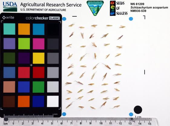 | | 2023 | | | | | | | Wild material | Tall perennial grass with red-orange stems. Hairy tufts on either side of seed. Have swollen dark red joints on stems. | 2142164 | W6 61209 |
| 15 | W6 61212 | NM930-542 | Eriocoma hymenoides (Roem. & Schult.) Rydb. | New Mexico, United States | W6 |  | | 2023 | | | | | | | Wild material | Perennial bunchgrass with branching panicles with dark seeds with hairy fluff extending from mature seeds. | 2142167 | W6 61212 |
| 16 | Ames 36024 | AS/FN/2023/011/221 | Fraxinus nigra Marshall | Wisconsin, United States | NC7 |  | | 2023 | COLLECTED | 02/26/2023 | Located just north of Leland approximately 0.70 miles along Hemlock Road, T10N R5E SW 1/4 NW 1/4 Sec. 18 | 43.34472800, -89.95099700 | 242 | Floodplain | Wild material | Single mother tree sample with signs of wood pecker damage on trunk. | 2141557 | Ames 36024 |
| 17 | NA 89039 | RJL2022IL-001 | Ptelea trifoliata L. | Illinois, United States | NA | | | 2022 | COLLECTED | 09/28/2022 | Site of plant habitat is located at 823 E Co Rd 1220, Hamilton, IL 62341 which is the property where Jacob's Geode Shop and Mine is located. This species is scattered and relatively common throughout the woodlands on this site. | 40.37848400, -91.35390200 | 175 | Plants growing in shade to part-shade of deciduous woodlands above a small creek.
Soils: The underlying geology of this area is of Mississippian origin and comprised of Warsaw Formation and Salem Limestone. Major lithological components include limestone that can be shaly, oolitic, bioclastic, or cherty. Minor lithological components include siltstone that can contain geodes or drusy quartz and can be calcareous.
Source: USGS Illinois Geologic Map Data (https://mrdata.usgs.gov/geology/state/sgmc-unit.php?unit=ILMws%3B0)
The surface soil profile of this area is Coffeen silt loam, 0 to 2 percent slopes, that are frequently flooded. The Coffeen series consists of very deep, somewhat poorly drained, moderately permeable soils on flood plains, low terraces or benches, toe slopes, and alluvial fans. They formed in silty alluvium. Much of the alluvium is of local origin derived from the nearby loess-covered uplands.
Source: NRCS Web Soil Survey (https://websoilsurvey.sc.egov.usda.gov/App/WebSoilSurvey.aspx) | Wild material | | 2139604 | NA 89039 |
| 18 | NA 89037 | RJL2022KS-004 | Fraxinus pennsylvanica Marshall | Kansas, United States | NA |  for this accession.") | | 2022 | COLLECTED | 09/21/2022 | Coronado Heights Park, Smoky View, Kansas hillsides surrounding the historic WPA circa 1932 Coronado Heights Castle located about 91 meters above the surrounding land. This plant is scattered and infrequent on the slopes of this site. | 38.61065700, -97.70408300 | 448 | Plants growing in full sun, under extreme exposure, rocky, dry and thin soils of this short grass prairie habitat on the slopes surrounding the summit of Coronado Heights Park. Plants tend
Soils: The underlying geology of this area is of Upper Cretaceous origin and comprised of Kiowa Shale or FM- light -gray to black illitic shale with thin coquinoidal limestone beds at the base; sandstone lenses are common. Cheyenne Sandstone-massive to cross-bedded, light-gray to buff fine-grained sandstone with lenses to be found in runoff zones where moisture is temporarily more abundant.of gray sandy shale and conglomerate.
Source: USGS Kansas Geologic Map Data (https://mrdata.usgs.gov/geology/state/sgmc-unit.php?unit=KSKkc%3B0)
The surface soil profile of this area is Lancaster-Hedville complex, 3 to 20 percent slopes. The Lancaster series consists of moderately deep, well drained soils that formed in residuum from sandstone and sandy shales; it can be up to 200 cm deep. Slopes range from 1-20%. Hedville soils have bedrock within 50 centimeters of the surface and occur on similar hillslope positions.
Source: NRCS Web Soil Survey (https://websoilsurvey.sc.egov.usda.gov/App/WebSoilSurvey.aspx) | Wild material | | 2139602 | NA 89037 |
| 19 | NA 89036 | RJL2022KS-003 | Cornus drummondii C. A. Mey. | Kansas, United States | NA | | | 2022 | COLLECTED | 09/21/2022 | Coronado Heights Park, Smoky View, Kansas hillsides surrounding the historic WPA circa 1932 Coronado Heights Castle located about 91 meters above the surrounding land. This plant is common and abundant on the slopes of this site. | 38.61348400, -97.70343100 | 475 | Plants growing in part shade to full sun, under extreme exposure, rocky, dry and thin soils of this short grass prairie habitat on the slopes surrounding the summit of Coronado Heights Park. The underlying geology of this area is of Upper Cretaceous origin and comprised of Kiowa Shale or FM- light -gray to black illitic shale with thin coquinoidal limestone beds at the base; sandstone lenses are common. Cheyenne Sandstone-massive to cross-bedded, light-gray to buff fine-grained sandstone with lenses of gray sandy shale and conglomerate.
Source: USGS Kansas Geologic Map Data (https://mrdata.usgs.gov/geology/state/sgmc-unit.php?unit=KSKkc%3B0)
The surface soil profile of this area is Lancaster-Hedville complex, 3 to 20 percent slopes. The Lancaster series consists of moderately deep, well drained soils that formed in residuum from sandstone and sandy shales; it can be up to 200 cm deep. Slopes range from 1-20%. Hedville soils have bedrock within 50 centimeters of the surface and occur on similar hillslope positions.
Source: NRCS Web Soil Survey (https://websoilsurvey.sc.egov.usda.gov/App/WebSoilSurvey.aspx)
Slope: 5-20% Aspect: all | Wild material | | 2139601 | NA 89036 |
| 20 | NA 89035 | RJL2022KS-002 | Rosa arkansana Porter | Kansas, United States | NA | | | 2022 | COLLECTED | 09/20/2022 | Coronado Heights Park, Smoky View, Kansas hillsides surrounding the historic WPA circa 1932 Coronado Heights Castle located about 91 meters above the surrounding land. This plant is quite abundant on the slopes of this site and highly competitive. | 38.61158800, -97.70427000 | 475 | Plants growing in part-sun to full sun, under extreme exposure, rocky, dry and thin soils of this short grass prairie habitat on the slopes surrounding the summit of Coronado Heights Park.
The underlying geology of this area is of Upper Cretaceous origin and comprised of Kiowa Shale or FM- light -gray to black illitic shale with thin coquinoidal limestone beds at the base; sandstone lenses are common. Cheyenne Sandstone-massive to cross-bedded, light-gray to buff fine-grained sandstone with lenses of gray sandy shale and conglomerate.
Source: USGS Kansas Geologic Map Data (https://mrdata.usgs.gov/geology/state/sgmc-unit.php?unit=KSKkc%3B0)
The surface soil profile of this area is Lancaster-Hedville complex, 3 to 20 percent slopes. The Lancaster series consists of moderately deep, well drained soils that formed in residuum from sandstone and sandy shales; it can be up to 200 cm deep. Slopes range from 1-20%. Hedville soils have bedrock within 50 centimeters of the surface and occur on similar hillslope positions.
Source: NRCS Web Soil Survey (https://websoilsurvey.sc.egov.usda.gov/App/WebSoilSurvey.aspx) | Wild material | | 2139600 | NA 89035 |
| 21 | W6 59936 | CBG-10659 | Carex crus-corvi Shuttlew. | Illinois, United States | W6 | | | 2021 | | | | | | | Wild material | | 2132515 | W6 59936 |
| 22 | NA 88287 | CBG-10561 | Cephalanthus occidentalis L. | Illinois, United States | NA | | | 2021 | | | | | | | Wild material | Plant numbers sampled estimated. | 2120156 | NA 88287 |
| 23 | W6 59120 | CBG-10069 | Juncus canadensis J. Gay ex Laharpe | Wisconsin, United States | W6 | | | 2021 | | | | | | | Wild material | | 2120049 | W6 59120 |
| 24 | W6 59174 | CBG-10461 | Juncus bufonius L. | Illinois, United States | W6 | | | 2021 | | | | | | | Wild material | | 2120096 | W6 59174 |
| 25 | W6 58575 | MARSB-215 | Juncus secundus P. Beauv. ex Poir. | New York, United States | W6 | | | 2021 | | | | | | | Wild material | Plants are in seed. The inflorescences are straw colored. The inflorescences are at the top of the stem, not spreading. It is taller than Juncus tenuis. | 2113505 | W6 58575 |
| 26 | W6 57084 | MARSB-216 | Carex annectens (E. P. Bicknell) E. P. Bicknell | New York, United States | W6 |  | | 2019 | | | | | | | Wild material | | 2097523 | W6 57084 |
| 27 | Ames 35216 | Potato Creek SP | Monarda sp. | Indiana, United States | NC7 |  | | 2019 | COLLECTED | 09/02/2019 | Potato Creek State Park located approximately 2.6 miles northeast of North Liberty, T36N R1E extreme eastern edge of NW 1/4 SW 1/4 Sec. 23. | 41.55439400, -86.38375900 | 222 | Degraded floodplain, along sides of elevated road bed. | Wild material | This taxa is currently undescribed and according to Campbell and Medley in The atlas of vascular plants in Kentucky (Accessed 06 September 2019) was provisionally named Monarda serotina by R.T. Simmers. Described as a broad-leaved form of M. fistulosa, generally intermediate between M. fistulosa and M. clinopodia, with probable hybrid origin. Typcial habitat is mesic woods and edges on lowlands. In contrast to M. fistulosa, this taxon has longer petioles (usually 2-3 cm versus 0.5-2.0 cm), lower leaf surfaces with scattered spreading hairs, and corollas are paler pink at tips to almost white with peak flowering occurring prior to M. fistulosa by approximately 1-2 weeks. Leaves are rather rugose, where upper leaf tissue between veins is visibly raised. This accession represents genetics from northern Indiana (Potato Creek State Park). Plants at the collection site in nature peaked flowering near 8 July 2019 where flower colors were more lavender in sun but pale in shade (Namestnik, S., personal communication, 15 July 2020). Peak fruiting occurs mid-August. Average height of plants sampled in nature estimated at 4.5' in height. | 2097752 | Ames 35216 |
| 28 | OPGC 7471 | CBG-8944 | Anemone canadensis L. | Iowa, United States | OPGC |  | | 2019 | | | | | | | Wild material | | 2092726 | OPGC 7471 |
| 29 | OPGC 7484 | CBG-9413 | Verbena hastata L. | Nebraska, United States | OPGC |  | | 2019 | | | | | | | Wild material | | 2092789 | OPGC 7484 |
| 30 | W6 56681 | CBG-9193 | Amorpha fruticosa L. | Nebraska, United States | W6 |  | | 2019 | | | | | | | Wild material | | 2092780 | W6 56681 |
| 31 | W6 56688 | CBG-9357 | Ageratina altissima (L.) R. M. King & H. Rob. var. altissima | Iowa, United States | W6 |  | | 2019 | | | | | | | Wild material | | 2092787 | W6 56688 |
| 32 | W6 56410 | NM930-485 | Sporobolus cryptandrus (Torr.) A. Gray | New Mexico, United States | W6 |  | | 2019 | | | | | | | Wild material | Sporobolus cryptandrus | 2091595 | W6 56410 |
| 33 | NA 88037 | NM930-317 | Fallugia paradoxa (D. Don) Endl. ex Torr. | New Mexico, United States | NA |  | | 2018 | | | | | | | Wild material | | 1966050 | NA 88037 |
| 34 | NA 88038 | NM930-318 | Fallugia paradoxa (D. Don) Endl. ex Torr. | New Mexico, United States | NA |  | | 2018 | | | | | | | Wild material | | 1966051 | NA 88038 |
| 35 | OPGC 6624 | NM930-323 | Mentzelia multiflora (Nutt.) A. Gray | New Mexico, United States | OPGC |  | | 2018 | | | | | | | Wild material | Mentzelia multiflora | 1966056 | OPGC 6624 |
| 36 | W6 54946 | NM930-444 | Sporobolus airoides (Torr.) Torr. | New Mexico, United States | W6 |  | | 2018 | | | | | | | Wild material | Sporobolus airoides | 1966173 | W6 54946 |
| 37 | NA 88194 | NM080-38 | Baccharis salicina Torr. & A. Gray | New Mexico, United States | NA |  | | 2018 | | | | | | | Wild material | | 1964364 | NA 88194 |
| 38 | W6 53810 | NM080-63 | Sphaeralcea angustifolia (Cav.) G. Don | New Mexico, United States | W6 |  | | 2018 | | | | | | | Wild material | | 1964388 | W6 53810 |
| 39 | Ames 34173 | APS/GD/2018/024/323 | Gymnocladus dioicus (L.) K. Koch | Kansas, United States | NC7 |  | | 2018 | COLLECTED | 03/15/2018 | Private property approximately 3.65 miles north of Lake City on Cottonwood Creek and Sand Creek watersheds. T30S R14W W1/2 Sec. 27, Barber County | 37.40016300, -98.84148600 | 595 | Cedar and elm woods. | Wild material | | 1957951 | Ames 34173 |
| 40 | NA 85024 | JDC/SS/2018/020/833 | Sapindus saponaria L. var. drummondii (Hook. & Arn.) L. D. Benson | Kansas, United States | NA |  | | 2018 | COLLECTED | 03/15/2018 | Private property approximately 3.65 miles north of Lake City on Cottonwood Creek and Sand Creek watersheds, T30S R14W, Barber County | 37.39995200, -98.84153900 | 593 | Cedar and elm woods. | Wild material | | 1957961 | NA 85024 |
| 41 | Ames 34720 | NM930-282 | Helianthus annuus L. | New Mexico, United States | NC7 |  | | 2018 | | | | | | | Wild material | | 1957580 | Ames 34720 |
| 42 | OPGC 7194 | NM930-236 | Sidalcea neomexicana A. Gray | New Mexico, United States | OPGC |  | | 2018 | | | | | | | Wild material | | 1957533 | OPGC 7194 |
| 43 | W6 53186 | NM930-239 | Achillea millefolium L. | New Mexico, United States | W6 |  | | 2018 | | | | | | | Wild material | | 1957536 | W6 53186 |
| 44 | W6 53195 | NM930-247 | Sporobolus cryptandrus (Torr.) A. Gray | New Mexico, United States | W6 |  | | 2018 | | | | | | | Wild material | | 1957545 | W6 53195 |
| 45 | W6 53210 | NM930-262 | Sporobolus contractus Hitchc. | New Mexico, United States | W6 |  | | 2018 | | | | | | | Wild material | | 1957560 | W6 53210 |
| 46 | W6 53211 | NM930-263 | Atriplex canescens (Pursh) Nutt. | New Mexico, United States | W6 |  | | 2018 | | | | | | | Wild material | | 1957561 | W6 53211 |
| 47 | W6 53212 | NM930-264 | Sphaeralcea fendleri A. Gray | New Mexico, United States | W6 |  | | 2018 | | | | | | | Wild material | | 1957562 | W6 53212 |
| 48 | W6 53213 | NM930-265 | Sporobolus airoides (Torr.) Torr. | New Mexico, United States | W6 |  | | 2018 | | | | | | | Wild material | | 1957563 | W6 53213 |
| 49 | W6 53214 | NM930-266 | Sporobolus flexuosus (Thurb. ex Vasey) Rydb. | New Mexico, United States | W6 |  | | 2018 | | | | | | | Wild material | | 1957564 | W6 53214 |
| 50 | W6 53254 | NM930-308 | Hordeum jubatum L. | New Mexico, United States | W6 |  | | 2018 | | | | | | | Wild material | | 1957604 | W6 53254 |
| 51 | NA 87967 | CBG-8082 | Cephalanthus occidentalis L. | Illinois, United States | NA |  | | 2017 | | | | | | | Wild material | | 1954783 | NA 87967 |
| 52 | W6 53003 | CBG-7115 | Angelica atropurpurea L. | Illinois, United States | W6 |  | | 2017 | | | | | | | Wild material | | 1954754 | W6 53003 |
| 53 | Ames 34052 | PB1701 | Betula papyrifera Marshall | Minnesota, United States | NC7 |  | | 2017 | COLLECTED | 09/16/2017 | Detroit Mountain area just east of Detroit Lakes approximately 2.9 miles, T139N R40W SW 1/4 NE 1/4 and NE 1/4 NE 1/4 NW 1/4 Sec. 21, Becker County | 46.81210900, -95.78208300 | 457 | Mixed deciduous woods. | Wild material | | 1954341 | Ames 34052 |
| 54 | Ames 34007 | JDC/PP/2017/052/806 | Pinus ponderosa P. Lawson & C. Lawson | Nebraska, United States | NC7 |  | | 2017 | COLLECTED | 08/29/2017 | Areas on both north and south sides of the Niobrara River between Long Pine and Springview, T32N R21W; T32N R20W; and T31N R21W in Brown and Keya Paha Counties. | 42.75716800, -99.74657300 | 685 | Dry, rocky ridgetops. | Wild material | Genetics represent the extreme eastern edgeo of the species native range. | 1953921 | Ames 34007 |
| 55 | W6 52062 | CA350-49 | Lotus corniculatus L. | Nevada, United States | W6 | | | 2017 | | | | | | | Wild material | | 1947197 | W6 52062 |
| 56 | Ames 33918 | APS/GD/2017/008/267 | Gymnocladus dioicus (L.) K. Koch | Minnesota, United States | NC7 |  | | 2017 | COLLECTED | 03/16/2017 | Minnesota River watershed covering approximately 9.0 river miles between Redwood Falls and Vicksburg Park, Renville County | 44.61447700, -95.14878600 | 254 | Mixed habitats, both upland dry sites, wet sites, and rocky sites. | Wild material | | 1946985 | Ames 33918 |
| 57 | Ames 33357 | JDC/UT/2016/018/733 | Ulmus thomasii Sarg. | Iowa, United States | NC7 |  | | 2016 | COLLECTED | 06/03/2016 | Malanaphy Springs State Preserve just northwest of Decorah, T99N R8W SW ¼ NW ¼ SE ¼ Sec. 31 | 43.34713800, -91.83840000 | 302 | Deciduous woods. Rocky substrate. 20 degree northwest-facing slope | Wild material | Ulmus thomasii (Rock elm) is an underutilized tree species both in conservation and in the urban landscape. Charles Sprague Sargent (first director of the Arnold Arboretum of Harvard University, Boston, MA) described the wood of Rock Elm as "heavy, hard, very strong and tough, closely grained, and susceptible of receiving a beautiful polish". Historically noted for a variety of uses in woodworking including furniture, heavy agricultural implements, timber frame buildings, pianos, hockey sticks, and hand tools. U. thomasii is extremely drought tolerant, adaptable to very calcareous soils, and compared to U. americana or U. rubra has a very conservative growth rate requiring minimal attention in regards to pruning. Rock elm naturally tends to develop into a nice structural specimen in the landscape, unlike other fast growing U. americana cultivars in the nursery trade needing frequent attention. Rock elm has very fissured bark and is well known for maintaining a strong central leader resulting in a very attractive, pyramidal form. Despite many literature sources stating that "wings" on the stems are a key identifiying characteristic, this trait is not reliable and many genotypes may completely lack "wings" on the stems. While growth habit and morphology of dormant buds (very pointy) are good traits to help aid in identification, fruits are the best way to confirm identity. Fruits are densly pubescent, often described as "inflated" and generally reach maturity a couple weeks after U. rubra and U. americana. U. thomasii flowering in central Iowa typically occurs the last week in April into the first week in May and are rather distinguishable from other Ulmus in being pendulous. Fruits are extremely prized treats for many birds, where fruits are often "robbed" prior to full maturity. Fruits are also highly prized by many other animals such as mice, squirrels, chipmunks, turkeys, etc. and are generally consumed within hours after fruit abscission. The native range of U. thomasii is concentrated in the northeastern United States and into Canada with disjunct populations documented in northwestern Missouri and northwestern Arkansas (Little, E. L. Jr. 1971). In the 1895 Silva of North America (vol. 7) it was stated that, “The value of the wood of the Rock Elm threatens its extinction and most of the large trees have already been cut.” Today, since rock elm is rather rare, especially in areas near the edges of its range, many states list the species as endangered or threatened warranting preservation efforts. This accession represents genetics from northeast Iowa (Winneshiek County). In an assessment of some of the largest Ulmus thomasii (native and cultivated) across Iowa, four of the nine largest specimens in Iowa are present in Malanaphy Springs State Preserve where this accession was sampled. The second largest U. thomasii in the state located in Malanaphy Springs was measured on 22 May 2020 with a circumference of 6.42', height of 86.58', and an average crown spread of 68.00' (180 points) (Rouw, M., personal communication, 8 February 2021). | 1940580 | Ames 33357 |
| 58 | W6 50152 | WY050-108 | Artemisia tridentata Nutt. subsp. tridentata | Wyoming, United States | W6 |  | | 2015 | | | | | | | Wild material | | 1927464 | W6 50152 |
| 59 | W6 50243 | CA690-054 | Juncus balticus Willd. subsp. mexicanus (Willd.) Snogerup | California, United States | W6 |  | | 2015 | | | | | | | Wild material | | 1927547 | W6 50243 |
| 60 | Ames 32960 | JDC/BP/2015/046/703 | Betula papyrifera Marshall | Iowa, United States | NC7 | | | 2015 | COLLECTED | 09/11/2015 | Ruby Woodland, T88N R19W NW 1/4 Sec. 8 Hardin County. | 42.45099600, -93.09671200 | 328 | Mid portions of north-facing slope (45-60 degrees) in cool, moist deciduous woods. Growing in association with Fraxinus nigra, Staphylea trifolia, Carpinus caroliniana, Quercus rubra, Fraxinus americana, Acer saccharum, Cornus alternifolia, Carya ovata, Urtica dioica, Amelanchier arborea, Ostrya virginiana, Hepatica sp., Smilax rotudifolia, Prunus Virginiana, Betula papyrifera, Betula alleghaniensis, Populus deltoides, Tilia americana, and Allium tricoccum. | Wild material | | 1927430 | Ames 32960 |
| 61 | W6 49557 | CBG-2512 | Glycyrrhiza lepidota Pursh | South Dakota, United States | W6 |  | | 2015 | | | | | | | Wild material | | 1926030 | W6 49557 |
| 62 | W6 49578 | CBG-2563 | Scirpus atrovirens Willd. | Illinois, United States | W6 |  | | 2015 | | | | | | | Wild material | | 1926049 | W6 49578 |
| 63 | W6 49594 | CBG-2586 | Schoenoplectus pungens (Vahl) Palla | South Dakota, United States | W6 |  | | 2015 | | | | | | | Wild material | | 1926064 | W6 49594 |
| 64 | W6 49603 | CBG-2602 | Elymus virginicus L. var. virginicus | Illinois, United States | W6 |  | | 2015 | | | | | | | Wild material | | 1926166 | W6 49603 |
| 65 | W6 49643 | CBG-2667 | Lycopus americanus Muhl. ex W. P. C. Barton | Illinois, United States | W6 |  | | 2015 | | | | | | | Wild material | | 1926108 | W6 49643 |
| 66 | Ames 32895 | APS/GD/2015/018/200 | Gymnocladus dioicus (L.) K. Koch | Oklahoma, United States | NC7 |  | | 2015 | COLLECTED | 03/15/2015 | Canadian County: Near/adjacent to unnamed creek that empties into the Canadian River, T12N R10W SW 1/4 Sec. 20. Private property approximately 4 miles northeast of Hinton. | 35.49409300, -98.28655400 | 434 | Bottomland. | Wild material | | 1925361 | Ames 32895 |
| 67 | Ames 32897 | APS/GD/2015/023/205 | Gymnocladus dioicus (L.) K. Koch | Oklahoma, United States | NC7 |  | | 2015 | COLLECTED | 03/16/2015 | Roger Mills County: Sergeant Major Creek watershed and surrounding area, T13N R24W SE 1/4 Sec. 24. Private property approximately 2.5 miles southwest of Cheyenne. | 35.58728500, -99.69840100 | 607 | Bottomlands, sandy soils and upland areas. | Wild material | | 1925363 | Ames 32897 |
| 68 | Ames 32898 | APS/GD/2015/025/207 | Gymnocladus dioicus (L.) K. Koch | Oklahoma, United States | NC7 |  | | 2015 | COLLECTED | 03/17/2015 | Ellis County: West Creek confluence with the Canadian River, T16N R24W E 1/4 Sec. 10. Packsaddle Wildlife Management Area approximately 18 miles north of Cheyenne. | 35.87199300, -99.72757700 | 608 | Bottomlands. | Wild material | | 1925364 | Ames 32898 |
| 69 | Ames 32887 | APS/GD/2015/003/185 | Gymnocladus dioicus (L.) K. Koch | Arkansas, United States | NC7 |  | | 2015 | COLLECTED | 03/04/2015 | Stone and Izard Counties: White River watershed, Ozark National Forest, Sylamore State Wildlife Management Area near Allison. | 35.95017300, -92.11129600 | 126 | Floodplain, base of slopes. | Wild material | | 1924365 | Ames 32887 |
| 70 | Ames 32812 | Ames 32812 | Euonymus atropurpureus Jacq. | Iowa, United States | NC7 |  | | 2014 | COLLECTED | 10/22/2014 | Chichaqua Bottoms Greenbelt, Polk County. | 41.77483000, -93.43145600 | 250 | Bottomland/floodplain forest of Skunk River watershed. | Wild material | One specimen sampled in nature was approximately 20 feet in height. In cultivation at NCRPIS, plants display attractive fall foliage colors ranging from pale pink to deep red. Fruits are ornamentally significant, varying in color from pale to bright pink. | 1921817 | Ames 32812 |
| 71 | Ames 32386 | JDC/BN/2014/013/515 | Betula nigra L. | Iowa, United States | NC7 |  | | 2014 | COLLECTED | 06/05/2014 | Bearbower Sand Prairie, T87N R9W SW 1/4 of SW 1/4 Sec. 32. | 42.29814100, -91.92822800 | 289 | Sand prairie with likely high water table. | Wild material | | 1919307 | Ames 32386 |
| 72 | Ames 32388 | JDC/BN/2014/015/517 | Betula nigra L. | Iowa, United States | NC7 |  | | 2014 | COLLECTED | 06/05/2014 | Princeton Wildlife Management Area, T80N R5E NE 1/4 Sec. 35. | 41.69417800, -90.34158400 | 177 | Wet, heavy soil floodplain. | Wild material | | 1919309 | Ames 32388 |
| 73 | Ames 32125 | JDC/SA/2013/051/495 | Spiraea alba Du Roi | Iowa, United States | NC7 | | | 2013 | COLLECTED | 12/17/2013 | Bearbower Sand Prairie, T87N R9W SW 1/4 of SW 1/4 of SW 1/4 of Sec. 32. | 42.29854000, -91.92799000 | 289 | Low, wet area near large specimens of Betula nigra and Populus deltoides. 1 to 4 percent slope. Clyde-Floyd complex (silty clay loam); poorly drained soils. Water table at approximately 12 inches | Wild material | | 1914769 | Ames 32125 |
| 74 | Ames 31982 | APS/GD/2013/004/089 | Gymnocladus dioicus (L.) K. Koch | Kansas, United States | NC7 |  | | 2013 | COLLECTED | 02/18/2013 | Walnut Creek watershed, southwest of Marysville, Sections 5, 8, and 17, T3S R6E, Marshall County. | 39.79300943, -96.78506600 | 382 | Dry floodplain. | Wild material | | 1907535 | Ames 31982 |
| 75 | Ames 31984 | APS/GD/2013/007/092 | Gymnocladus dioicus (L.) K. Koch | Kansas, United States | NC7 |  | | 2013 | COLLECTED | 02/19/2013 | Salt Creek, west of Minneapolis, Sections 4 and 11, T11S R4W, Ottawa County. | 39.12575800, -97.75880300 | 384 | Floodplain. | Wild material | | 1907537 | Ames 31984 |
| 76 | Ames 31676 | GA12010001 | Fraxinus pennsylvanica Marshall | Minnesota, United States | NC7 |  | | 2012 | COLLECTED | NEAR 09/24/2012 | Near Mashaug Creek just north of Twin Valley, Norman County. | 47.28851660, -96.26865000 | 327 | Upland forest, dominated by Populus deltoides. | Wild material | | 1906587 | Ames 31676 |
| 77 | Ames 31678 | GA12003001 | Fraxinus pennsylvanica Marshall | Minnesota, United States | NC7 |  | | 2012 | COLLECTED | NEAR 09/26/2012 | Buffalo River State Park along the Buffalo River, east of Glyndon, Clay County. | 46.86481660, -96.46406660 | 302 | Floodplain. Transistion zone between prairie and forest | Wild material | | 1906589 | Ames 31678 |
| 78 | Ames 31217 | GA15004001 | Fraxinus pennsylvanica Marshall | North Dakota, United States | NC7 |  | | 2011 | COLLECTED | 09/24/2011 | Along Forest Service Road 842, SW 1/4 of Section 2, T147N, R99W, Long X Divide Quad, Badlands, Little Missouri National Grasslands, McKenzie County. | 47.57730000, -103.26760000 | 674 | Clay substrate. | Wild material | Requests will be filled using inventory sample 11ncao02 (JDZ/2011/004/002) unless otherwise noted. | 1896696 | Ames 31217 |
| 79 | Ames 31086 | 691 | Fraxinus pennsylvanica Marshall | New York, United States | NC7 |  | | 2011 | COLLECTED | 09/10/2011 | Winters Road, south of Main Street, Chemung County. | 42.13200000, -76.92800000 | 275 | Floodplain of Cuthrie Run | Wild material | | 1891472 | Ames 31086 |
| 80 | Ames 31087 | 692 | Fraxinus pennsylvanica Marshall | New York, United States | NC7 |  | | 2011 | COLLECTED | 09/11/2011 | McMaster at Jasper-North Cameron Road, Steuben County. | 42.20400000, -77.41500000 | 349 | Edge of Canisteo River, adjacent farmland. | Wild material | | 1891473 | Ames 31087 |
| 81 | Ames 31091 | 713 | Fraxinus pennsylvanica Marshall | New York, United States | NC7 |  | | 2011 | COLLECTED | 09/17/2011 | Old River Road Trail and White Wagon Road, on north and south sides of Chemung River, respectively, Chemung County. | 42.00700000, -76.55900000 | 241 | Urban-distrurbed floodplain forest, north side of Chemung River; roadside edge and adjacent farm fields on south side of Chemung River. Steep, south-facing slope | Wild material | | 1891477 | Ames 31091 |
| 82 | Ames 30681 | JDC/FP/2010/068/338 | Fraxinus pennsylvanica Marshall | Wisconsin, United States | NC7 |  | | 2010 | COLLECTED | 09/28/2010 | East side of Lower Turtle Lake, north of boat ramp on 4th Street, SE 1/4 of NE 1/4 of Section 34, T34N R14W, Almena Quad, east of Turtle Lake, Barron County. | 45.38861000, -92.07153000 | 358 | | Uncertain improvement status | | 1853839 | Ames 30681 |
| 83 | Ames 30685 | JDC/FP/2010/075/345 | Fraxinus pennsylvanica Marshall | Wisconsin, United States | NC7 |  | | 2010 | COLLECTED | 09/30/2010 | Parking area for Richter Lane boat ramp, north side of Trauba Road, near northeast shore of Lake Poygan, SE 1/4 of NE 1/4 of Section 36, T20N R14E, Lake Poygan Quad, Winnebago County. | 44.16382000, -88.76668000 | 230 | | Wild material | | 1853843 | Ames 30685 |
| 84 | Ames 30603 | JDC/FP/2010/055/325 | Fraxinus pennsylvanica Marshall | Kansas, United States | NC7 |  | | 2010 | COLLECTED | 09/19/2010 | Along highway 160, Mouse Creek watershed, just east of Independence, Montgomery County. | 37.22496000, -95.66045000 | 233 | Shallow soils in bedrock with seeps. | Wild material | | 1848898 | Ames 30603 |
| 85 | Ames 30518 | APS/GD/2009/020/029 | Gymnocladus dioicus (L.) K. Koch | Iowa, United States | NC7 |  | | 2010 | COLLECTED | 04/11/2010 | North Raccoon River Watershed, Section 6, Section 7, and NW 1/4 of NW 1/4 of Section 18, between Iowa Highway 44 (240th Street) and Adel, Dallas County. | 41.67297500, -94.03777500 | 320 | Bottomland/floodplain forest. | Wild material | Plants ranged from 60-75 feet tall and averaged 20 inches d.b.h. Seeds seemed very small and round. | 1836761 | Ames 30518 |
| 86 | Ames 30511 | JDC/GD/2010/015/285 | Gymnocladus dioicus (L.) K. Koch | Iowa, United States | NC7 |  | | 2010 | COLLECTED | 03/21/2010 | Along 170th Street, east of Old Lincoln Highway, SE 1/4 of Section 24, NE1/4 of NW 1/4 of Section 11, SE 1/4 of NE 1/4 of Section 25, NW 1/4 of Section 25, NW 1/4 of SE 1/4 of Section 14, NW 1/4 of NE 1/4 of Section 14, T77N, R44W, Honey Creek Quad and SW 1/4 of SW 1/4 of SW 1/4 of Section 2, SE 1/4 of SE 1/4 of Section 3, T77N, R44W, Loveland Quad, south-southeast of Loveland, Pottawattamie County. | 41.46948600, -95.86295900 | 353 | Bluffs of Loess Hills. Slope generally 30-40%, variation in aspect. Elevation ranged between 323 and 379 meters. | Wild material | Average plant height was approximately 55 feet (range 40-70 feet). Average diameter at breast height was approximately 12 inches. (range 7-26 inches). Two specimens measured in the 23-26 inches d.b.h. range. | 1836389 | Ames 30511 |
| 87 | Ames 30493 | APS/GD/2010/015/050 | Gymnocladus dioicus (L.) K. Koch | Iowa, United States | NC7 |  | | 2010 | COLLECTED | 02/24/2010 | Iowa River Watershed, near Toolesboro T73N R2W NW 1/4 Sec. 1 and also SE 1/4 NW 1/4 Sec. 14. | 41.15416700, -91.04153300 | 170 | Floodplain/mouth of Iowa River and base of northeast-facing slope. | Wild material | Kentucky Coffeetree is native to North America centered throughout majority of the Midwest from central Ohio west to central Kansas and from southern Minnesota south to northern Arkansas (Gymnocladus dioicus Native Distribution from Elbert Little's "Atlas of United States Trees"). Kentucky coffeetree is a picturesque shade tree that is extremely tolerant to highly alkaline and also slightly acidic soils, tolerant to both extreme drought and flood events, and has no serious insect or disease problems. These traits make G. dioicus a promising candidate among diverse tree genera to replace ash (Fraxinus) trees affected by the emerald ash borer (Agrilus planipennis) or oaks (Quercus) being affected by oak wilt (caused by the fungus Ceratocystis fagacearum) (Schmitz & Carstens 2017). Specimens at the collection site in nature averaged (n=7) 14.50” DBH and 53’ in height (Individual Tree measurements (DBH/Height): #1 = 13"/40', #2 = 15"/50', #3 = 14"/40', #4 = 15"/50', #5 = 13"/30', #6 = 16"/90', and #7 = 15"/70'). Sampling in 2010 estimated more than one hundred genetically distinct trees – the most coffeetrees noted in any single area observed throughout the species native range (Schmitz & Carstens 2018). A return site visit in 2016, estimated that three-quarters of the coffeetrees were dead or in decline after becoming overgrown by hops (Humulus sp.), a result of major flooding events in 2013 and 2014 where floods in 2013 persisted for nearly three months. Flood stage for this population of coffeetrees in the NW ¼ of Sec. 1 resides at 538 MSL (Mean Sea Level) which can be compared against data from the Mississippi River Lock and Dam 17 (Flood Events 2009-2024), where water levels were recorded 14' above ground level where multiple trees of Ames 30493 were sampled. | 1831352 | Ames 30493 |
| 88 | Ames 30090 | 01A | Fraxinus pennsylvanica Marshall | Kansas, United States | NC7 |  | | 2009 | COLLECTED | 09/14/2009 | Along Cedar Creek, 4.5 miles south of Cedar Point, Chase County. | 38.19250000, -96.81194444 | | Along a stream. | Wild material | | 1813253 | Ames 30090 |
| 89 | Ames 29975 | JDC/GD/2009/004/154 | Gymnocladus dioicus (L.) K. Koch | Nebraska, United States | NC7 |  | | 2009 | COLLECTED | 03/20/2009 | Ponca State Park, approximately 2 miles north of Ponca, T30N R6E Sec. 3 Ponca Quad., Dixon County. | 42.60166667, -96.71444444 | 365 | Variable from mid-level elevation sloped area to bottomland type. Variable exposure. 0-60 degrees of slope with variable aspects. | Wild material | Plants between 40 and 75 feet in height and 8 to 26 inches DBH. | 1798767 | Ames 29975 |
| 90 | Ames 29976 | JDC/GD/2009/005/155 | Gymnocladus dioicus (L.) K. Koch | Nebraska, United States | NC7 |  | | 2009 | COLLECTED | 03/20/2009 | Wiseman Wildlife Management Area, approximately 3 miles northeast of Wynot, T32N R3E Sec. 8 and Sec. 9 Meckling Quad., Cedar County. | 42.76055556, -97.09472222 | 363 | Hillside. 100% filtered exposure. 40 degrees of slope with a northern aspect. | Wild material | Plants sampled measured between 30 and 45 feet in height and 8 to 16 inches DBH. | 1798768 | Ames 29976 |
| 91 | Ames 29848 | JDC/GD/2009/001/151 | Gymnocladus dioicus (L.) K. Koch | Minnesota, United States | NC7 |  | | 2009 | COLLECTED | 02/02/2009 | Minnesota River Watershed approximately 2-3 miles north-northeast of Le Sueur, NW 1/4 of NW 1/4 of Section 19, T112N, R25W, Tyrone Township, Le Sueur Quad, Le Sueur County. | 44.49833333, -93.88666667 | 238 | Floodplain/mesic woods adjacent to river. Majority found on lower slopes (20%, west facing) & where ravines met bottomland. Few found at higher elevation; dry ridge on slope (30%, south facing). | Wild material | Plant size ranged from approximately 40 to 90 feet in height and 36 to 60 d.b.h. | 1794565 | Ames 29848 |
| 92 | Ames 29615 | JDC/FN/2008/018/088 | Fraxinus nigra Marshall | Iowa, United States | NC7 |  | | 2008 | COLLECTED | 09/24/2008 | Adjacent to Des Moines River, along Dolliver Park Avenue between Prairie Creek and Bone Yard Hollow, Dolliver State Park, W 1/2 of Section 35, Webster County. | 42.39750000, -94.07583333 | 289 | Open picnic/campground/park areas, flood plain, mesic forest. | Wild material | Some of the largest specimens sampled in nature at collection site were approximately 2.0' DBH and 100+ feet in height. | 1786594 | Ames 29615 |
| 93 | WLP 2487 | JDC-0112006 | Viburnum prunifolium L. | Iowa, United States | NA |  | | 2006 | COLLECTED | 09/12/2006 | Lake of Three Fires State Park, Bedford Quad.T68N R33W extreme NW corner of Sec. 7 | 40.71194444, -94.68583333 | 360 | Moderately shaded deciduous woods. | Wild material | Noted in nature as small understory trees, approximately 15-20 feet in height with clean foliage under moderate to heavy shade. In cultivation, fall color seems to vary from year to year ranging from dark purplish to bright red with peak fall color occurring around the later part of October (central Iowa). Flowers are white with peak flowering occurring in early-mid May. The range of this North American native is noted throughout the eastern and southeastern U.S. This accession represents genetics from the extreme northwestern corner of the species native range. Viburnum prunifolium in Iowa is rather rare and generally restricted and more commonly found in the extreme southeast corner of the state. This disjunct population in Taylor County (southwest Iowa) has been questioned as to whether it is a true native population or a naturalized escape. Additional V. prunifolium elsewhere in southwest Iowa has not been reported/documented. Immediately to the south of Taylor County, V. prunifolium is documented throughout most of Missouri and thus it is suspected that these genetics do represent a true native population. | 1708694 | WLP 2487 |