| 0 | PI 664899 | JDC/PV/2009/092/242 | Prunella vulgaris L. | Ohio, United States | NC7 |  | | 2009 | COLLECTED | 10/16/2009 | Wayne National Forest, near Dirtyface Creek, SE 1/4 of SW 1/4 of Section 21, T6N, R17W, Gallia Quad, Jackson County. | 38.80750000, -82.53000000 | 210 | Open prairie. Variable soil types present. | Wild material | | 1823940 | PI 664899 |
| 1 | PI 664896 | JDC/PV/2008/022/092 | Prunella vulgaris L. | Missouri, United States | NC7 |  | | 2008 | COLLECTED | 10/06/2008 | Northeast of intersection of Highway 63 and County Road J, approximately 1 mile north of Greentop, Schuyler County. | 40.36722222, -92.56111111 | 295 | Shortgrass prairie with both wet and dry substrates present. | Wild material | | 1788217 | PI 664896 |
| 2 | PI 664897 | JDC/PV/2008/061/131 | Prunella vulgaris L. | Illinois, United States | NC7 |  | | 2008 | COLLECTED | 10/12/2008 | Along 2150 North Road, east of Irvington, SW 1/4 of NE 1/4 of Section 15, T1S, R1E, Walnut Hill Quad, Jefferson County. | 38.43833333, -89.07833333 | 161 | Only on south side of road; northern exposure; mostly shaded due to woody vegetation. | Wild material | | 1788218 | PI 664897 |
| 3 | PI 664898 | JDC/PV/2008/071/141 | Prunella vulgaris L. | Illinois, United States | NC7 |  | | 2008 | COLLECTED | 10/13/2008 | Along Opossum Creek on US Highway 51, SE 1/4 of SE 1/4 of Section 16, T10N, R1E, Oconee Quad, Shelby County. | 39.30527778, -89.08388889 | 200 | | Wild material | | 1788219 | PI 664898 |
| 4 | PI 664900 | 60974-H218105-01-06 | Prunella vulgaris L. subsp. lanceolata (W. P. C. Barton) Piper & Beattie | Oregon, United States | NC7 |  | | 2007 | COLLECTED | PRE 09/21/2006 | Marion and Polk Counties. | 44.88650600, -123.13119500 | | Prairie remnants. | Wild material | | 1740913 | PI 664900 |
| 5 | PI 664888 | JM200708001 | Prunella vulgaris L. | South Ossetia, Georgia | NC7 | | | 2007 | COLLECTED | 08/28/2007 | Along dirt road between Orbete and Nichbisi, toward Mt. Oidgori, Kartli Region. | 41.73555556, 44.41138889 | 1767 | Secondary subalpine meadow. Roadside. | Wild material | | 1744191 | PI 664888 |
| 6 | PI 664889 | JM200708014 | Prunella vulgaris L. | South Ossetia, Georgia | NC7 | | | 2007 | COLLECTED | 08/29/2007 | Tana River Gorge, on road from Gori to Tana, Kartli Region. | 41.90000000, 44.05944444 | 799 | Along Tana River. | Wild material | | 1744192 | PI 664889 |
| 7 | PI 664890 | JM200708017 | Prunella vulgaris L. | South Ossetia, Georgia | NC7 | | | 2007 | COLLECTED | 08/29/2007 | Tana River Gorge, upper Boshurebi village on road from Gori, Kartli Region. | 41.85694444, 43.85861111 | 1398 | Along Tana river in meadow; evidence of grazing. | Wild material | | 1744193 | PI 664890 |
| 8 | PI 664891 | JM200708035 | Prunella vulgaris L. | South Ossetia, Georgia | NC7 | | | 2007 | COLLECTED | 08/31/2007 | Along road to Gombori, Kakheti Region. | 41.80638889, 45.14277778 | 854 | Meadow beside road. | Wild material | | 1744194 | PI 664891 |
| 9 | PI 664892 | JM200708040 | Prunella vulgaris L. | South Ossetia, Georgia | NC7 | | | 2007 | COLLECTED | 08/31/2007 | Sabaduri Forest, road to Tskvarichamia, near Gululebe village, Mtkheta Region. | 41.90777778, 44.91166667 | 1415 | Old growth forest edge. | Wild material | | 1744195 | PI 664892 |
| 10 | PI 664893 | BH200709044 | Prunella vulgaris L. | South Ossetia, Georgia | NC7 | | | 2007 | COLLECTED | 09/01/2007 | 40 m off Georgian Military Highway, near Gaudare, Mtkheta Region. | 42.49305556, 44.46666667 | 2217 | Alpine meadow. | Wild material | | 1744196 | PI 664893 |
| 11 | PI 664894 | JM200709073 | Prunella vulgaris L. | South Ossetia, Georgia | NC7 | | | 2007 | COLLECTED | 09/05/2007 | Along road to Akhaltsikadzia, Samckhe Javakheti Region. | 41.78277778, 43.47833333 | 1436 | Open pine/spruce forest edge. | Wild material | | 1744197 | PI 664894 |
| 12 | PI 664895 | JM200709114 | Prunella vulgaris L. | Ajaria, Georgia | NC7 | | | 2007 | COLLECTED | 09/10/2007 | Chakuistskali River Valley Gorge, Mtrila National Forest, Ajara Region. | 41.70027778, 41.81416667 | 76 | Colchic forest. Rocky, creek side seep. | Wild material | | 1744198 | PI 664895 |
| 13 | PI 664886 | Lab No. 109402 | Prunella vulgaris L. | Oregon, United States | NC7 | | | 2007 | COLLECTED | 07/21/2005 | Bald Hill, Benton County. | 44.56520000, -123.33200000 | | | Wild material | | 1729554 | PI 664886 |
| 14 | PI 664887 | Lab No. 109403 | Prunella vulgaris L. | Oregon, United States | NC7 | | | 2007 | COLLECTED | NEAR 08/03/2006 | Samples collected from multiple sites in the Pacific Northwest all located in Oregon including: Clear Creek in Clackamas County, Kingston Prairie in Linn County, Stayton Sublimity Interchange, Highway 22-Old Mehema Road, and Sublimity Prairie in Marion County, | 45.05848200, -122.55002900 | | | Wild material | | 1729556 | PI 664887 |
| 15 | PI 656842 | JM20061010 | Prunella vulgaris L. | Missouri, United States | NC7 | | | 2006 | COLLECTED | 09/25/2006 | Forest Service Road 2000, Highway Y, approximately 8 miles south of intersection with Highway 8, Washington County. | 37.82388889, -91.07722222 | 289 | Roadside prairie remnant. | Wild material | | 1715757 | PI 656842 |
| 16 | PI 664884 | JM20061006 | Prunella vulgaris L. | Missouri, United States | NC7 | | | 2006 | COLLECTED | 09/25/2006 | South of Cuba and Hwy 19, roadside. West Sullivan, Crawford County. | 38.03972222, -91.38888889 | 297 | Oak-hickory savannah, roadside. | Wild material | | 1715756 | PI 664884 |
| 17 | PI 664885 | JM20061020 | Prunella vulgaris L. | South Carolina, United States | NC7 | | | 2006 | COLLECTED | 09/28/2006 | East side of State Road 1149, north of Highway 11, Pickens, Pickens County. | 34.93500000, -82.88750000 | 262 | Cove hardwood forest, roadside. | Wild material | | 1715758 | PI 664885 |
| 18 | PI 656839 | 1 | Prunella vulgaris L. | Iowa, United States | NC7 | | | 2006 | COLLECTED | 09/19/2006 | 200 yards southwest of Whitetail parking lot, Don Williams County Park, near western border of park, SE 1/4 of NW 1/4 of SW 1/4 of Section 5, T84N, R27W, Yell Township, Boone County. | 42.11166667, -94.02388889 | 313 | Native prairie remnant. Afternoon sun. Moist-west mesic soil. | Wild material | Plants up to 18 inches tall. | 1712923 | PI 656839 |
| 19 | PI 656840 | 4 | Prunella vulgaris L. | Iowa, United States | NC7 | | | 2006 | COLLECTED | 09/15/2006 | 100 yards northeast of sewage treatment plant, McHose Park, Boone, NE 1/4 of NW 1/4 of SW 1/4 of Section 33, T84N, R26W, Des Moines Township, Boone County. | 42.04222222, -93.88861111 | 344 | Southeast shoreline of pond and small spring on northwest corner of pond. Partial sun. Wet soil. | Wild material | Plants up to 18 inches tall. | 1712924 | PI 656840 |
| 20 | PI 656841 | 7 | Prunella vulgaris L. | Iowa, United States | NC7 | | | 2006 | COLLECTED | 09/26/2006 | Parking lot on deadend farm driveway through woods to Boone River, Department of Natural Resources public area, 0.5 mile west of 305th Street, T87N R26W NW 1/4 of SE 1/4 of NE 1/4 of Sec. 15, Webster Township, Hamilton County | 42.34916667, -93.85916667 | 289 | Bottom ground field. Partial to full sun. Moist soil. Site extends 0.25 mile along driveway | Wild material | Plants up to 24-26 inches tall. | 1712927 | PI 656841 |
| 21 | PI 664880 | 5 | Prunella vulgaris L. | Iowa, United States | NC7 | | | 2006 | COLLECTED | 09/27/2006 | Department of Natural Resources public area, approximately 0.75 mile northwest of Des Moines River bridge, west of Luther, SW 1/4 of NW 1/4 of SE 1/4 of Section 29, T83N, R26W, Marcy Township, Boone County. | 41.96944444, -93.90333333 | 329 | Far west side of Des Moines River floodplain spring. Full sun. Edge of wet spring. | Wild material | Plants 16 inches tall. | 1712925 | PI 664880 |
| 22 | PI 664881 | 6 | Prunella vulgaris L. | Iowa, United States | NC7 | | | 2006 | COLLECTED | 10/02/2006 | Near the east end of Reindeer Ridge, Ledges State Park, NE 1/4 of NE 1/4 of NW 1/4 of Section 21, T83N, R26W, Worth Township, Boone County. | 41.99388889, -93.88444444 | 329 | Large slump below sandstone cliff outcrop. Few feet up from Pea's creek floodplain. Partial sun. Northwest facing. Moist-wet clay soil. | Wild material | Plants 12 inches tall. | 1712926 | PI 664881 |
| 23 | PI 664882 | 9 | Prunella vulgaris L. | Iowa, United States | NC7 | | | 2006 | COLLECTED | 09/22/2006 | 300 yards south of Carl Fritz Henning Shelter House, 300 yards northeast of Lost Lake parking lot, Lower Ledges Road, Ledges State Park, NW 1/4 of NE 1/4 of SW 1/4 of Section 21, T83N, R26W, Worth Township, Boone County. | 41.98555556, -93.88833333 | 329 | Cleared woods for powerline right-of-way. Moist-wet mostly clay soil. Plants scattered over entire hilltops. Site approximately 250 yards by 30 feet. | Wild material | Plants 16-18 inches tall. | 1712928 | PI 664882 |
| 24 | PI 664883 | 10 | Prunella vulgaris L. | Iowa, United States | NC7 | | | 2006 | COLLECTED | 09/15/2006 | Downhill, east-southeast of primitive campground parking lot, Ledges State Park, NE 1/4 of SW 1/4 of SW 1/4 of Section 15, T83N, R26W, Worth Township, Boone County. | 41.99638889, -93.87111111 | 329 | 3-4 small springs at bottom of west facing hillside and clay slump on west side of a deep gulley. Dense woods. Very wet soil. | Wild material | Plants up to 11 inches tall. | 1712929 | PI 664883 |
| 25 | PI 664877 | Ames 28312 | Prunella vulgaris L. | Iowa, United States | NC7 | | | 2006 | COLLECTED | 09/10/2006 | Near center of NW 1/4 of Section 21, T69N, R9W, Keosauqua, Van Buren County. | 40.76583333, -91.90388889 | 175 | Muddy, rocky bed of Rock Creek. Partial shade; nearly flat slope, open to the south. Alluvium soil mixed with rocks; very stony with good drainage. Rare population abundance. Floodplain forest. | Wild material | | 1707771 | PI 664877 |
| 26 | PI 664878 | JM20060801 | Prunella vulgaris L. | Iowa, United States | NC7 | | | 2006 | COLLECTED | 08/31/2006 | 1 mile north of 150th on 560th Avenue (1 mile west of Interstate 35 and 1 mile south of County Road E-18), Doolittle Prairie State Preserve, Story County. | 42.14910000, -93.58920000 | 255 | Mesic prairie (pothole). 0-10 degrees of slope. | Wild material | Plants 25-30 cm in height. | 1707772 | PI 664878 |
| 27 | PI 664879 | JM20060802 | Prunella vulgaris L. | Iowa, United States | NC7 |  | | 2006 | COLLECTED | 08/31/2006 | 2505 Tullamore Lane, Ames, Story County. | 42.08840000, -93.57870000 | 317 | Garden; open pollinated. 0-10 degrees of slope. | Cultivated material | Plants 50-60 cm in height. | 1707773 | PI 664879 |
| 28 | PI 664876 | 16 | Prunella vulgaris L. | Missouri, United States | NC7 | | | 2004 | COLLECTED | 10/19/2004 | Railroad tracks, roadside along Interstate 44, Crawford County. | 38.03526600, -91.51978300 | 325 | Prairie remnant, partly mowed. 1-5 degrees of slope with a western aspect. | Wild material | 15-30 cm tall. | 1668207 | PI 664876 |
| 29 | PI 664873 | JM2004005 | Prunella vulgaris L. | North Carolina, United States | NC7 | | | 2004 | COLLECTED | 10/02/2004 | Highway 276 to East Fork Road, Pine Shore Lakes, Brevard, Transylvania County. | 35.12611111, -82.72944444 | 851 | Pine-oak forest. Lakeside on private land. 15 degrees of slope with a northwestern aspect. | Wild material | 15-40 cm tall. | 1667584 | PI 664873 |
| 30 | PI 664874 | JM2004022 | Prunella vulgaris L. | North Carolina, United States | NC7 | | | 2004 | COLLECTED | 10/08/2004 | Roan Mountain, along road from Carvers Gap to Rhododendron gardens, Pisgah National Forest, Mitchell County. | 36.10166667, -82.12666667 | 1754 | Roadside, spruce/fir community. 30-40 degrees of slope with a northeastern aspect. | Wild material | Up to 35 cm tall. | 1667585 | PI 664874 |
| 31 | PI 664875 | JM2004023 | Prunella vulgaris L. | North Carolina, United States | NC7 | | | 2004 | COLLECTED | 10/07/2004 | Off Forest Service Road 479S, approximately 1 mile north of Blue Ridge Parkway, near Rocky Branch Creek, Bent Creek Experimental Forest, Pisgah National Forest, Buncombe County. | 35.46333333, -82.66277778 | 812 | Trail side, rich mesic cove forest. 20 degrees of slope with a northeastern aspect. | Wild material | 15-35 cm tall. | 1667586 | PI 664875 |
| 32 | PI 440618 | P-68 | Prunella vulgaris L. | Russian Federation | NC7 | | | 1978 | COLLECTED | 07/25/1977 | Mt. Strizhament. | 44.77638889, 42.01527778 | 810 | | Wild material | Flowers blue. Possible ornamental. | 1335554 | PI 440618 |
| 33 | W6 61967 | OR930A-04 | Prunella vulgaris L. | Oregon, United States | W6 |  | | 2024 | | | | | | | Wild material | This is found on carpeting roadsides and disturbed areas | 2168372 | W6 61967 |
| 34 | W6 61975 | OR930A-16 | Prunella vulgaris L. | Oregon, United States | W6 |  | | 2024 | | | | | | | Wild material | Flowers in bracteate terminal spike corolla purple | 2168427 | W6 61975 |
| 35 | W6 61978 | OR930A-20 | Prunella vulgaris L. | Oregon, United States | W6 |  | | 2024 | | | | | | | Wild material | Flowers in bracteate terminal spikes corolla purple | 2168377 | W6 61978 |
| 36 | W6 61280 | OR080-98 | Prunella vulgaris L. subsp. lanceolata (W. P. C. Barton) Piper & Beattie | Oregon, United States | W6 |  | | 2023 | | | | | | | Wild material | Purple/violet flowers form tight inflorescences above 20-inch, square stems. | 2142724 | W6 61280 |
| 37 | W6 61285 | OR090B-320 | Prunella vulgaris L. subsp. lanceolata (W. P. C. Barton) Piper & Beattie | Oregon, United States | W6 |  | | 2023 | | | | | | | Wild material | Clumps or single stem, hairy, unbranched. Leaves lance- to egg-shaped, entire or slightly toothed; opposite. Flowers with short stalks in stout round head above 2 spreading, pointed bracts at stem top. Flower purple, pink or white; upper lip hood-like; lower lip 3-lobed. 0.75-1.75ft tall. | 2142729 | W6 61285 |
| 38 | W6 61286 | OR090B-321 | Prunella vulgaris L. subsp. lanceolata (W. P. C. Barton) Piper & Beattie | Oregon, United States | W6 |  | | 2023 | | | | | | | Wild material | Clumps or single stem, hairy, unbranched. Leaves lance- to egg-shaped, entire or slightly toothed; opposite. Flowers with short stalks in stout round head above 2 spreading, pointed bracts at stem top. Flower purple, pink or white; upper lip hood-like; lower lip 3-lobed. 0.75-1.75ft tall. | 2142730 | W6 61286 |
| 39 | W6 58232 | CA930E-10 | Prunella vulgaris L. | California, United States | W6 | | | 2020 | | | | | | | Wild material | Flowers pink. | 2107612 | W6 58232 |
| 40 | W6 57661 | CA180-208 | Prunella vulgaris L. | California, United States | W6 | | | 2020 | | | | | | | Wild material | SOS 92nd Shipment | 2104959 | W6 57661 |
| 41 | W6 56047 | OR090B-251 | Prunella vulgaris L. | Oregon, United States | W6 |  | | 2019 | | | | | | | Wild material | Prunella vulgaris | 1971293 | W6 56047 |
| 42 | W6 53711 | OR110-1033 | Prunella vulgaris L. subsp. lanceolata (W. P. C. Barton) Piper & Beattie | Oregon, United States | W6 |  | | 2018 | | | | | | | Wild material | | 1964289 | W6 53711 |
| 43 | Ames 34205 | JDC/PV/2018/038/851 | Prunella vulgaris L. | Texas, United States | NC7 | _thumbnail.jpg "Click for 4 image(s) for this accession.") | | 2018 | COLLECTED | 05/23/2018 | Located 4.10 miles east of Mineola along County Road 2650 just 1.00 miles north of intersection with FM 1801, Wood County | 32.67184300, -95.41677700 | 142 | Roadside. Very diverse vegetation. | Wild material | Plants approximately 10" tall. Seeds collected right at peak maturity (23 May 2018). | 1963388 | Ames 34205 |
| 44 | W6 52402 | OR090A-299 | Prunella vulgaris L. subsp. lanceolata (W. P. C. Barton) Piper & Beattie | Oregon, United States | W6 |  | | 2017 | | | | | | | Wild material | | 1948657 | W6 52402 |
| 45 | W6 50303 | OR110-806 | Prunella vulgaris L. | Oregon, United States | W6 |  | | 2015 | | | | | | | Wild material | | 1927603 | W6 50303 |
| 46 | Ames 32767 | JDC/PV/2014/036/538 | Prunella vulgaris L. | Iowa, United States | NC7 |  | | 2014 | COLLECTED | 09/03/2014 | Crossman Prairie State Preserve, approximately 5 miles northeast of Riceville, Howard County. | 43.40777300, -92.47500720 | 413 | Remnant tallgrass prairie. | Wild material | | 1921315 | Ames 32767 |
| 47 | Ames 31624 | APS/PV/2012/004/080 | Prunella vulgaris L. | Oregon, United States | NC7 |  | | 2012 | COLLECTED | 09/05/2012 | Salmon River Trailhead, off Salmon River Road, approximately 3.5 miles south of Welches, Mount Hood National Forest, Clackamas County. | 45.27788000, -121.93951300 | | | Wild material | | 1905315 | Ames 31624 |
| 48 | Ames 32633 | PRVUL2-SOS-OR931-72-11 | Prunella vulgaris L. subsp. lanceolata (W. P. C. Barton) Piper & Beattie | Oregon, United States | NC7 |  | | 2012 | COLLECTED | 2011 | | 45.86958000, -122.81948000 | | | Wild material | | 1905136 | Ames 32633 |
| 49 | Ames 31184 | APS/PV/2011/024/074 | Prunella vulgaris L. | Colorado, United States | NC7 |  | | 2011 | COLLECTED | 10/2022 | Arapaho National Recreation Area, small island at Monarch Lake, Grand County. | 40.10789000, -105.74384000 | 2546 | Moist habitat, a few feet from waters edge. | Wild material | Very short, compact plants. | 1892269 | Ames 31184 |
| 50 | Ames 31098 | 363 | Prunella vulgaris L. | New York, United States | NC7 |  | | 2011 | COLLECTED | 09/12/2011 | Hanging Bog Game Management Area, access road between Punkey Hollow and Federal Road, Allegany County. | 42.32400000, -78.22600000 | 603 | Grassy roadside. | Wild material | | 1891484 | Ames 31098 |
| 51 | Ames 31437 | PRVU-SOS-OR110-214-10 | Prunella vulgaris L. | Oregon, United States | NC7 |  | | 2011 | COLLECTED | PRE 2011 | | 42.63623333, -122.98576110 | | | Wild material | | 1868884 | Ames 31437 |
| 52 | Ames 31438 | PRVUL2-SOS-OR100-140-10 | Prunella vulgaris L. subsp. lanceolata (W. P. C. Barton) Piper & Beattie | United States | NC7 |  | | 2011 | COLLECTED | 01/01/2011 | | 43.41736111, -123.61077778 | | | Wild material | | 1856107 | Ames 31438 |
| 53 | Ames 30389 | JDC/PV/2009/116/266 | Prunella vulgaris L. | Ohio, United States | NC7 |  | | 2009 | COLLECTED | 10/19/2009 | Erie Sand Barrens State Nature Preserve, Kimball Quad, Erie County. | 41.35861111, -82.70805556 | 209 | Sandy, dry soils. | Wild material | | 1823941 | Ames 30389 |
| 54 | Ames 30306 | JPN-2009-009 | Prunella vulgaris L. subsp. asiatica (Nakai) H. Hara | Hokkaidô, Japan | NC7 |  | | 2009 | COLLECTED | 09/09/2009 | Hokkaido University Botanical Garden, Sapporo. | 43.06527778, 141.34416667 | 25 | Garden collection. | Cultivated material | Seed collected from cultivated plants grown from seed of wild origin. Short plant, about 6 cm tall. | 1823699 | Ames 30306 |
| 55 | Ames 30307 | JPN-2009-054 | Prunella vulgaris L. subsp. asiatica (Nakai) H. Hara | Hokkaidô, Japan | NC7 | | | 2009 | COLLECTED | 09/11/2009 | Near town of Niseko Waisu. | 42.89444444, 140.66888889 | 579 | Open edge of road in drainage ditch. | Wild material | Low growing perennial herb. Purple flower, about 2-3 cm long. | 1823700 | Ames 30307 |
| 56 | Ames 30308 | JPN-2009-128 | Prunella vulgaris L. subsp. asiatica (Nakai) H. Hara | Iwate, Japan | NC7 |  | | 2009 | COLLECTED | 09/20/2009 | Toshichi-onsen (spa). | 39.94166667, 140.85805560 | 1413 | Sub-alpine area near sulfur springs. Open sunny gravel path along road. | Wild material | Short herbaceous perennial with upright inflorescences. Purple flowers. | 1823701 | Ames 30308 |
| 57 | Ames 30163 | LQ/PV/2009/001/001 | Prunella vulgaris L. | Wisconsin, United States | NC7 |  | | 2009 | COLLECTED | 09/21/2009 | Snow Bottoms State Natural Area, SW 1/4 of SW 1/4 of Section 35, T7N, R1W, Highland West Quad, Grant County. | 43.03277778, -90.46777778 | 262 | Gravel path. 30% slope; south and west facing. | Wild material | | 1819744 | Ames 30163 |
| 58 | Ames 30164 | LQ/PV/2009/004/004 | Prunella vulgaris L. | Wisconsin, United States | NC7 |  | | 2009 | COLLECTED | 09/23/2009 | South side of Chub Lake, SE 1/4 of NE 1/4 of Section 25, T9N, R13E, Waterloo Quad, Dodge County. | 43.21944444, -88.89388889 | 239 | Crawfish River watershed. Wet, open woodland. | Wild material | | 1819745 | Ames 30164 |
| 59 | Ames 30165 | LQ/PV/2009/005/005 | Prunella vulgaris L. | Wisconsin, United States | NC7 |  | | 2009 | COLLECTED | 09/23/2009 | Lazy Days Campground, near Green Lake, SE 1/4 of SW 1/4 of Section 33, T12N, R20E, Newburg Quad, Washington County. | 43.45555556, -88.11416667 | 265 | Drainage area. | Wild material | | 1819746 | Ames 30165 |
| 60 | Ames 30166 | LQ/PV/2009/006/006 | Prunella vulgaris L. | Wisconsin, United States | NC7 |  | | 2009 | COLLECTED | 09/23/2009 | Very close to Pebble Brook, Vernon State Wildlife Area, NW 1/4 of NW 1/4 of Section 4, T5N, R19E, Genesee Quad, Waukesha County. | 42.92805556, -88.26722222 | 241 | Wetland open woods. | Wild material | | 1819747 | Ames 30166 |
| 61 | Ames 29995 | 1989.053 | Prunella vulgaris L. subsp. asiatica (Nakai) H. Hara | Honshu, Japan | NC7 |  | | 2009 | COLLECTED | 10/17/1989 | Nosemura, Mount Gomadon, Koyosan Area, Nara Prefecture. | 34.05000000, 135.56666667 | 1230 | Common in shaded areas under herbaceous growth. Exposed hillside covered with scrub and sasa thicket. | Cultivated material | Cultivated material from wild collection. | 1802293 | Ames 29995 |
| 62 | Ames 29048 | Lab No. 109404 | Prunella vulgaris L. | Oregon, United States | NC7 |  | | 2007 | COLLECTED | 08/2006 | Samples collected from multiple sites in the Pacific Northwest all located in Lane County, Orgegon including: Helt, Oxbow East, Westmoreland, Willowcreek, Applegate, Camas Swale, Spores, and Fisher Butte. | 43.91677900, -122.88870000 | | | Wild material | | 1729555 | Ames 29048 |
| 63 | Ames 29050 | Lab No. 109405 | Prunella vulgaris L. | Oregon, United States | NC7 |  | | 2007 | COLLECTED | NEAR 08/08/2006 | Samples collected from multiple sites in the Pacific Northwest all located in Orgeon including: Crowe, Baskett Slough, and Rupers in Polk County; Cooke and Mt. Richmond in Yamhill County, and Cooper Mountain in Washington County. | 45.20089500, -123.10043700 | | | Wild material | | 1729557 | Ames 29050 |
| 64 | Ames 29934 | 202790 | Prunella vulgaris L. | California, United States | NC7 |  | | 2005 | COLLECTED | 08/25/2003 | Ecoregion 14, Humboldt County. Elk River Trail in Headwaters Reserve. | 40.69111000, -124.13639000 | 60 | Redwood forest. | Wild material | Forb 0.15-0.75 meters tall. | 1674315 | Ames 29934 |
| 65 | PI 704844 sos | R. parviflorus Nutt. OR080-35 | Rubus parviflorus Nutt. | Oregon, United States | COR |  | | 2018 | | | | | | | Wild material | | 1957618 | PI 704844 sos |
| 66 | PI 704845 sos | V. parvifolium OR080-49 | Vaccinium parvifolium Sm. | Oregon, United States | COR |  | | 2018 | | | | | | | Wild material | | 1957632 | PI 704845 sos |
| 67 | PI 673986 | TX-03 | Rudbeckia grandiflora (Sweet) C. C. Gmel. ex DC. | Texas, United States | OPGC | 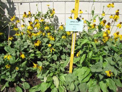 | | 2010 | COLLECTED | 05/26/2010 | Upper West Gulf Coastal Plain. Harrison County. South of Marshall Texas. East on 2625, cross 31, left onto CR 1111, Brad spann road veer right. | 32.47050000, -94.21594400 | 97 | Meadow(Maintained ROW under power lines). Land form: Rolling hills. Land Use: Roadside ROW. Geology: Sandstone. Soil Texture: Sandy. Soil Color: Brown. | Wild material | Erect, clumped, glabrous to 60 cm tall. Flowers numerous, yellow ray florets. | 1897287 | PI 673986 |
| 68 | PI 673987 | TX-07 | Coreopsis lanceolata L. | Texas, United States | OPGC | | | 2010 | COLLECTED | 05/26/2010 | Upper West Gulf Coastal Plain. Harrison County.SH 43 between Marshall and Karnack Texas. | 32.63652800, -94.18847200 | 90 | Maintained Roadside ROW adjacent to mixed pine forest. Land form: Rolling hills to flat. Land Use: Roadside ROW. Geology: Sandstone. Soil Texture: Sandy. Soil Color: Tan. | Wild material | Erect, clumped, glabrous to 70 cm tall. Flowers numerous, yellow ray florets. | 1897289 | PI 673987 |
| 69 | PI 673988 | TX-08 | Rudbeckia maxima Nutt. | Texas, United States | OPGC |  | | 2010 | COLLECTED | 05/26/2010 | Upper West Gulf Coastal Plain. Harrison County.SH 43 between Marshall and Karnack Texas. | 32.63652800, -94.18847200 | 90 | Maintained Roadside ROW adjacent to mixed pine forest. Land form: Rolling hills to flat. Land Use: Roadside ROW. Geology: Sandstone. Soil Texture: Sandy. Soil Color: Tan. | Wild material | Large blue-green leathery leaves mostly basal, plants to 2 m tall, yellow ray florets. | 1897290 | PI 673988 |
| 70 | PI 664377 | F. vesca f. alba JPN-2009-063 | Fragaria vesca L. subsp. vesca f. alba (Ehrh.) Staudt | Hokkaidô, Japan | COR | | | 2009 | COLLECTED | 09/12/2009 | Kombu-Dake | 42.73721000, 140.65747000 | 494 | Edge of trail in open woods, growing in gravel, lots of light, growing with Fragaria iinumae, Prunella vulgaris, Potentilla fragarioides, broad leaf plantain and Dryopterus. | Wild material | From September 7 to 25, 2009, U.S. scientists K. Hummer and J. Postman from the USDA Agricultural Research Service and Japanese scientists H. Iketani and H. Imanishi from the Japanese Ministry of Forestry and Fisheries/National Institute of Agrobiological Sciences, and Akita Agricultural University collaborated on an expedition to collect temperate fruit genera in Hokkaido and northern Honshu, Japan. An agreement between Japan and the USDA specified the terms of exchange, and materials collected were shared between scientists of both countries. | 1824041 | PI 664377 |
| 71 | PI 673982 | JDC/RH/2009/025/175 | Rudbeckia hirta L. | Wisconsin, United States | OPGC |  | | 2009 | COLLECTED | 09/21/2009 | Near the Blue River, Snow Bottoms State Natural Area, SW 1/4 of SW 1/4 of Section 35, T7N, R1W, Highland West Quad, Grant County. | 43.03611111, -90.46777778 | 262 | Riverbank. Associated with Achillea millefolium, Agrimonia, Monarda fistulosa, Prunella vulgaris, Trifolium pratense, and Ulmus. | Wild material | | 1819750 | PI 673982 |
| 72 | PI 604738 | 298 | Trifolium pratense L. | Krasnodar, Russian Federation | W6 | | | 1996 | COLLECTED | 09/19/1995 | Krasnodarskiy kray, nearest village is Zazulin. | | | Now cut/grazed. Slope 0-5%. Open. Moist, ridgetop (watershed). Vegetation closed, seasonal broad-leafed herb vegetation. | Wild material | Dominant herb/grass species Prunella vulgaris, Plantago lanceolata, Daucus carota, Fillipendula vulgaris, Leontodon caucasicus, Molinia caerulea, Dorycnium herbaceum. Population distribution uniform, abundance occasinal. Growth habit spreading. Extensive regional climate data available in spreadsheet format or image maps in raster format suitable for GIS analysis. Contact Dr. Stephanie L. Greene (sgreene@ars-grin.gov). | 1531023 | PI 604738 |
| 73 | PI 611030 | VIR 297 | Dactylis glomerata L. | Russian Federation | W6 | | | 1996 | COLLECTED | 09/19/1995 | Krasnodarskiy kray. Nearest village Zazulin. | 44.47861111, 39.93611111 | 200 | Area cut/grazed. Slope 0-5%. Light open. Moist, ridgetop (watershed). pH 5.8. Vegetation closed, seasonal broad-leafed herb vegetation. | Wild material | Dominant herb/grass species Prunella vulgaris, Plantago lanceolata, Daucus carota, Fillipendula vulgaris, Leontodon caucasicus, Molinia caerulea, Dorycnium herbaceum. Population distribution uniform, abundance occasional. Growth habit erect. Extensive regional climate data available in spreadsheet format or image maps in raster format suitable for GIS analysis. Contact Dr. Stephanie L. Greene (sgreene@ars-grin.gov). | 1517982 | PI 611030 |
| 74 | PI 611031 | VIR 300 | Dactylis glomerata L. | Russian Federation | W6 | | | 1996 | COLLECTED | 09/19/1995 | Krasnodarskiy kray. Nearest village Zazulin. | 44.47861111, 39.93611111 | 200 | Area cut/grazed. Slope 0-5%. Light open. Moist, ridgetop (watershed). pH 5.8. Vegetation closed, seasonal broad-leafed herb vegetation. | Wild material | Dominant herb/grass species Prunella vulgaris, Plantago lanceolata, Daucus carota, Fillipendula vulgaris, Leontodon caucasicus, Molinia caerulea, Dorycnium herbaceum. Population distribution uniform, abundance occasional. Growth habit spreading. Extensive regional climate data available in spreadsheet format or image maps in raster format suitable for GIS analysis. Contact Dr. Stephanie L. Greene (sgreene@ars-grin.gov). | 1517983 | PI 611031 |
| 75 | PI 634060 | 295 | Trifolium hybridum L. | Krasnodar, Russian Federation | W6 | | | 1996 | COLLECTED | 09/19/1995 | Krasnodarskiy kray, nearest village Zazulin. | | | Now cut/grazed. Slope 0-5%. Open. Moist, ridgetop (watershed). Vegetation closed, seasonal broad-leafed herb vegetation. | Wild material | Dominant herb/grass species Prunella vulgaris, Plantago lanceolata, Daucus carota, Fillipendula vulgaris, Leontodon caucasicus, Molinia caerulea, Dorycnium herbaceum. Population distribution uniform, abundance frequent. Growth habit spreading. Extensive regional climate data available in spreadsheet format or image maps in raster format suitable for GIS analysis. Contact Dr. Stephanie L. Greene (sgreene@ars-grin.gov). | 1531021 | PI 634060 |
| 76 | PI 641480 | 296 | Lotus corniculatus L. | Krasnodar, Russian Federation | W6 |  | | 1996 | COLLECTED | 09/19/1995 | Krasnodarskiy kray, nearest village is Zazulin. | | | Now cut/grazed. Slope 0-5%. Open. Moist, ridgetop (watershed). Vegetation closed, seasonal broad-leafed herb vegetation. | Wild material | Dominant herb/grass species Prunella vulgaris, Plantago lanceolata, Daucus carota, Fillipendula vulgaris, Leontodon caucasicus, Molinia caerulea, Dorycnium herbaceum. Population distribution uniform, abundance occasional. Growth habit spreading. Extensive regional climate data available in spreadsheet format or image maps in raster format suitable for GIS analysis. Contact Dr. Stephanie L. Greene (sgreene@ars-grin.gov). | 1531022 | PI 641480 |
| 77 | PI 641481 | 299 | Lotus corniculatus L. | Krasnodar, Russian Federation | W6 |  | | 1996 | COLLECTED | 09/19/1995 | Krasnodarskiy kray, nearest village is Zazulin. | | | Now cut/grazed. Slope 0-5%. Open. Moist, ridgetop (watershed). Vegetation closed, seasonal broad-leafed herb vegetation. | Wild material | Dominant herb/grass species Prunella vulgaris, Plantago lanceolata, Daucus carota, Fillipendula vulgaris, Leontodon caucasicus, Molinia caerulea, Dorycnium herbaceum. Population distribution uniform, abundance occasional-frequent. Growth habit spreading. Extensive regional climate data available in spreadsheet format or image maps in raster format suitable for GIS analysis. Contact Dr. Stephanie L. Greene (sgreene@ars-grin.gov). | 1531024 | PI 641481 |
| 78 | PI 558162 | SCl 4519 | Solanum palustre Poepp. ex Schltdl. | Neuquén, Argentina | NR6 | | | 1991 | COLLECTED | 02/20/1990 | Huiliches. On dirt road on N side of Lago Lacar, on way to Hua-Hum, 24.5 km W of route 234, just N of San Martin de Los Andes. | -40.13333333, -71.51666667 | 915 | Roadside, near drainage ditch, under Nothofagus, Chusquea, Prunella vulgaris. | Wild material | Roadside, near drainage ditch, under Nothofagus, Chusquea, Prunella vulgaris. Flowers gone. | 1453134 | PI 558162 |
| 79 | W6 62516 | FWS0300-106 | Rudbeckia hirta L. | Michigan, United States | W6 |  | | 2025 | | | | | | | Wild material | | 2192214 | W6 62516 |
| 80 | W6 62541 | FWS0300-65 | Coreopsis lanceolata L. | Michigan, United States | W6 |  | | 2025 | | | | | | | Wild material | Only scouted the part of the population on USFWS property | 2192239 | W6 62541 |
| 81 | W6 61951 | OR090B-340 | Juncus oxymeris Engelm. | Oregon, United States | W6 |  | | 2024 | | | | | | | Wild material | Robust population | 2168356 | W6 61951 |
| 82 | W6 61977 | OR930A-19 | Chamaenerion angustifolium (L.) Scop. subsp. angustifolium | Oregon, United States | W6 |  | | 2024 | | | | | | | Wild material | Flowers pink purple 4 lobed stigma 8 stamens | 2168376 | W6 61977 |
| 83 | Ames 36158 | JDC/MM/2023/058/1090 | Monarda maxmedleyi J. J. N. Campb. & Floden | Kentucky, United States | NC7 |  | | 2023 | COLLECTED | 08/09/2023 | South of Morehead approximately 5.8 miles on Pretty Ridge Road (highway 1274) just north of intersection with Road 801 | 38.10409000, -83.42610600 | 353 | Roadside. High-quality remnant prairie/open woods in immediate area. | Wild material | Plants measuring 12-18" in height. Spreading vegetatively via rhizomes. Majority of specimens with light pink flowers but a few have white flowers. Peak flowering at collection site occurred near 25th of May (2023). | 2158363 | Ames 36158 |
| 84 | W6 61403 | CBG- 10836 | Triosteum aurantiacum E. P. Bicknell | Wisconsin, United States | W6 |  | | 2023 | | | | | | | Wild material | | 2142285 | W6 61403 |
| 85 | W6 61417 | CBG- 10852 | Verbesina alternifolia (L.) Britton ex Kearney | Illinois, United States | W6 |  | | 2023 | | | | | | | Wild material | | 2142299 | W6 61417 |
| 86 | W6 61418 | CBG- 10853 | Agastache scrophulariifolia (Willd.) Kuntze | Illinois, United States | W6 |  | | 2023 | | | | | | | Wild material | | 2142300 | W6 61418 |
| 87 | Ames 35940 | AS/ML/2022/009/140 | Monarda lindheimeri Engelm. & A. Gray | Texas, United States | NC7 |  | | 2022 | COLLECTED | 08/05/2022 | Located approximately 6.60 miles west of Huntsville along highway 30. | 30.69318900, -95.65743400 | 108 | Roadside fenceline. | Wild material | | 2140530 | Ames 35940 |
| 88 | Ames 35955 | AS/ML/2022/024/155 | Monarda lindheimeri Engelm. & A. Gray | Texas, United States | NC7 |  | | 2022 | COLLECTED | 08/05/2022 | Located just north of Roans Prairie approximately 1.27 miles on highway 90 N. | 30.60214700, -95.94961100 | 116 | Roadside, woodland edge. | Wild material | | 2140545 | Ames 35955 |
| 89 | Ames 35956 | AS/ML/2022/025/156 | Monarda lindheimeri Engelm. & A. Gray | Texas, United States | NC7 |  | | 2022 | COLLECTED | 08/05/2022 | Located just south of Bedias approximately 4.34 miles on highway 90 N (east side). | 30.71054100, -95.96554500 | 98 | Roadside, woodland edge. | Wild material | | 2140546 | Ames 35956 |
| 90 | W6 60625 | CA930E-17 | Camassia quamash (Pursh) Greene | California, United States | W6 |  | | 2022 | | | | | | | Wild material | Flowers purple. | 2138744 | W6 60625 |
| 91 | OPGC 8297 | CBG-10428 | Lobelia siphilitica L. | Illinois, United States | OPGC | | | 2021 | | | | | | | Wild material | | 2120072 | OPGC 8297 |
| 92 | W6 59148 | CBG-10429 | Scirpus cyperinus (L.) Kunth | Illinois, United States | W6 | | | 2021 | | | | | | | Wild material | | 2120073 | W6 59148 |
| 93 | W6 59151 | CBG-10432 | Eupatorium perfoliatum L. | Illinois, United States | W6 | | | 2021 | | | | | | | Wild material | | 2120076 | W6 59151 |
| 94 | W6 59171 | CBG-10456 | Carex annectens (E. P. Bicknell) E. P. Bicknell | Illinois, United States | W6 | | | 2021 | | | | | | | Wild material | | 2120093 | W6 59171 |
| 95 | W6 59177 | CBG-10464 | Carex normalis Mack. | Illinois, United States | W6 | | | 2021 | | | | | | | Wild material | | 2120098 | W6 59177 |
| 96 | W6 59200 | CBG-10494 | Cinna arundinacea L. | Illinois, United States | W6 | | | 2021 | | | | | | | Wild material | | 2120119 | W6 59200 |
| 97 | Ames 35560 | Hawthorn Prairie | Echinacea pallida (Nutt.) Nutt. | Iowa, United States | NC7 |  | | 2020 | COLLECTED | 08/14/2020 | Hawthorn Lake Wildlife Management Area, located one mile south of Barnes City on the northeast side of Hawthorn Lake, Mahaska County | 41.48270000, -92.45230000 | 260 | Remnant prairie. | Wild material | Plants sampled in nature measuring approximately 2-3 feet in height. | 2107723 | Ames 35560 |
| 98 | Ames 35541 | NAO/MB/2020/01/53 | Monarda bradburiana L. C. Beck | Illinois, United States | NC7 |  | | 2020 | COLLECTED | 07/16/2020 | Eagle Point Bay area located at southwest portion of Lake of Egypt, T11S R2E NE1/4 Sec. 1 and T11S R2E NW1/4 Sec. 6, Johnson County | 37.59183900, -88.93008100 | 168 | Roadside, wooded rocky hillside. | Wild material | | 2106720 | Ames 35541 |
| 99 | W6 57621 | 916734 | Pisum sativum L. | Samegrelo-Zemo Svaneti, Georgia | W6 | | | 2019 | COLLECTED | 07/10/2016 | Ontopo. Samegrelo-Zemo Svaneti Region. Abasha Municipality. Village Ontopo. | 42.23191667, 42.24030556 | 65 | Agricultural land . Among corn crops. Soil Texture: Loam. | Wild material | | 2098618 | W6 57621 |
| 100 | W6 57622 | 916745 | Pisum sativum L. | Samegrelo-Zemo Svaneti, Georgia | W6 | | | 2019 | COLLECTED | 07/15/2016 | Lesichine. Samegrelo-Zemo Svaneti Region. Chkhorotsku Municipality. Village Lesichine. | 42.47147222, 42.10952778 | 130 | Agricultural land. In corn crops. Soil Texture: Loam. | Wild material | | 2098619 | W6 57622 |
| 101 | W6 57623 | 916756 | Pisum sativum L. | Samegrelo-Zemo Svaneti, Georgia | W6 | | | 2019 | COLLECTED | 07/16/2016 | Mukhurcha. Samegrelo-Zemo Svaneti Region. Martvili Municipality. Village Mukhurcha. | 42.32341667, 42.32341667 | 70 | Agricultural land. In corn crops. Soil Texture: Loam. | Wild material | | 2098620 | W6 57623 |
| 102 | Ames 35237 | Ames 35237 | Monarda fistulosa L. | New Mexico, United States | NC7 |  | | 2019 | COLLECTED | 10/03/2019 | Railroad Canyon located approximately 6.38 miles west of Kingston just north of highway 152, T16S R10W Grant County | 32.91279900, -107.81640300 | 2173 | Sparsely wooded canyon with small creek. | Wild material | | 2097773 | Ames 35237 |
| 103 | NA 88206 | CBG-9427 | Ceanothus americanus L. | Illinois, United States | NA |  | | 2019 | | | | | | | Wild material | | 2092801 | NA 88206 |
| 104 | OPGC 7368 | OR090B-241 | Eriophyllum lanatum (Pursh) J. Forbes | Oregon, United States | OPGC |  | | 2019 | | | | | | | Wild material | | 1971285 | OPGC 7368 |
| 105 | OPGC 7369 | OR090B-242 | Clarkia amoena (Lehm.) A. Nelson & J. F. Macbr. | Oregon, United States | OPGC |  | | 2019 | | | | | | | Wild material | | 1971286 | OPGC 7369 |
| 106 | Ames 34315 | JDC/ML/2018/039/852 | Monarda luteola Singhurst & W. C. Holmes | Texas, United States | NC7 |  | | 2018 | COLLECTED | 07/18/2018 | Located 4.10 miles east of Mineola on west side of County Road 2650 just 0.88 miles north of intersection with FM 1801, Wood County | 32.66918400, -95.41726400 | 139 | Very diverse vegetation. Roadside. | Wild material | Plants with lemon scent, pubescent stems and leaves with faint yellow flowers measuring circa 1.0-2.5' in height. Plants likely reached peak flower on 15 May 2018. Seeds likely reached full maturity around first week in July (2018). | 1964622 | Ames 34315 |
| 107 | OPGC 6477 | OR110-1031 | Rudbeckia glaucescens Eastw. | Oregon, United States | OPGC |  | | 2018 | | | | | | | Wild material | | 1964287 | OPGC 6477 |
| 108 | W6 53272 | OR080-39 | Bromus pacificus Shear | Oregon, United States | W6 |  | | 2018 | | | | | | | Wild material | | 1957622 | W6 53272 |
| 109 | W6 53280 | OR080-47 | Scirpus microcarpus J. Presl & C. Presl | Oregon, United States | W6 |  | | 2018 | | | | | | | Wild material | | 1957630 | W6 53280 |
| 110 | Ames 33733 | JDC/BP/2016/039/754 | Betula pumila L. | Iowa, United States | NC7 |  | | 2016 | COLLECTED | 08/29/2016 | Clear Creek Wildlife Management Area located approximately 4.5 miles east, southeast of Dorchester just off Golden Ridge Road. T100N R5W NW ¼ SE ¼ NW ¼ Sec. 27 Allamakee County. | 43.45316700, -91.42476900 | 215 | High-quality, wetland fen of Clear Creek watershed. Growing in association with Solidago speciosa, Gentiana alba, Salix candida, Salix pedicellaris, Spiranthes (either cernua or magnicamporum), Parnassia (likely glauca), Monarda fistulosa, Eutrochium maculatum, Prunella vulgaris, Impatiens capensis, Betula papyrifera (2 specimens noted), Betula hybrid (1 specimen noted, likely B. x sandbergii), and Helianthus grosseserratus. | Wild material | | 1942684 | Ames 33733 |
| 111 | OPGC 4242 | JDC/LS/2015/055/712 | Lobelia siphilitica L. | Iowa, United States | OPGC | | | 2015 | COLLECTED | 10/02/2015 | Approximatley 4.25 miles northwest of Ames, T84N R25W SE 1/4 SE 1/4 SE 1/4 Sec. 25. | 42.04909700, -93.70113000 | | Roadside, rather wet. Shallow areas with standing water. Growing in association with Ambrosia trifida, Bromus inermis, Chamaecrista fasciculata, Juniperus virginiana, Prunella vulgaris, Carex molesta, Sorghastrum nutans, Cannabis sativa, Solidago, and Monarda fistulosa. | Wild material | Abundant occurrence. Peak bloom occurred first week in September (2015). Peak harvest first week in October (2015). Plants ranging from 1-2.5' in height. | 1927776 | OPGC 4242 |
| 112 | Ames 32965 | JDC/BA/2015/051/708 | Betula alleghaniensis Britton | Iowa, United States | NC7 | | | 2015 | COLLECTED | 09/15/2015 | Yellow River State Forest, T97N R4W northern edge of SW 1/4 NW 1/4 Sec. 36 | 43.17782100, -91.26584600 | 227 | North-facing algific talus slope (45-60 degrees) adjacent to Paint Creek. Moist deciduous woods. Growing in association with Fraxinus nigra, Staphylea trifolia, Carpinus caroliniana, Quercus rubra, Acer saccharum, Cornus alternifolia, Amelanchier arborea, Ostrya virginiana, Viburnum opulus var. americanum, Cornus rugosa, Cornus alternifolia, Zanthoxylum americanum, Viburnum rafinesqueanum, Cypripedium pubescens, Ribes sp.,Corylus sp., Juniperus virginiana, Dirca palustris, Ulmus thomasii, Prunella vulgaris, Diervilla lonicera, Quercus macrocarpa, Carya cordiformis, Taxus canadensis, Tilia americana, Adiantum pedatum, and Aconitum noveboracense. | Wild material | | 1927435 | Ames 32965 |
| 113 | Ames 32966 | JDC/VA/2015/052/709 | Viburnum opulus L. var. americanum Aiton | Iowa, United States | NC7 |  | | 2015 | COLLECTED | 09/15/2015 | Yellow River State Forest, T97N R4W northern edge of SW ¼ NW ¼ Sec. 36. | 43.17778200, -91.26642800 | 239 | North-facing algific talus slope (45-60 degrees) adjacent to Paint Creek. Moist deciduous woods. | Wild material | Formerly known as Viburnum trilobum, American highbush cranberry (V. opulus var. americanum) is a North American native shrub that is utilized as an important ornamental and conservation plant that is also harvested as a minor fruit crop (jams/jellies). In nature, this variety is generally found in moist habitats typically along stream banks and swamps where ample moisture is readily available. The native range of V. opulus var. americana is concentrated in the northeastern United States and into Canada (Little, E. L. Jr. 1977). Attractive ornamental characteristics includes showy lacecap flowers in spring and bright red fruits and foliage in the fall. Fruits are tart with a hint of sweetness. The European highbush cranberry (V. opulus var. opulus) is nearly identical to American highbush cranberry other than small glands (<1 mm) on the petiole making the exact determination very challenging resulting in common misidentifications. A major difference between the American and European highbush cranberries is that the European variety produces unpalatable fruit. Recent research has shown that American and European highbush cranberries are genetically distinct and that plants of hybrid origin are uncommon (Tork et al. 2025). Vigorous early spring growth and good tolerance to late spring frosts. Genetic analysis from Tork et al. 2025 confirmed that genetics of this accession represents American highbush Cranberry (Viburnum opulus var. americanum). This accession represents genetics from northeast Iowa and thus the extreme western edge of the species native range. | 1927436 | Ames 32966 |
| 114 | OPGC 6160 | CBG-2674 | Boltonia asteroides (L.) LʼHér. var. recognita (Fernald & Griscom) Cronquist | Illinois, United States | OPGC |  | | 2015 | | | | | | | Wild material | | 1926172 | OPGC 6160 |
| 115 | Ames 32761 | JDC/BP/2014/034/536 | Betula pumila L. | Iowa, United States | NC7 |  | | 2014 | COLLECTED | 09/03/2014 | Crossman Prairie State Preserve, approximately 5 miles northeast of Riceville, Howard County. | 43.40777300, -92.47500720 | 413 | Remnant tallgrass prairie. | Wild material | | 1921309 | Ames 32761 |
| 116 | Ames 32769 | JDC/SA/2014/033/535 | Spiraea alba Du Roi | Iowa, United States | NC7 |  | | 2014 | COLLECTED | 09/03/2014 | Crossman Prairie State Preserve, approximately 5 miles northeast of Riceville. | 43.40777300, -92.47500720 | 413 | Remnant tallgrass prairie. Clyde-Floyd complex (1-4 percent slopes) depth to water table: 12-42 inches, 0-17 inches silty clay loam, somewhat poorly drained | Wild material | | 1921317 | Ames 32769 |
| 117 | OPGC 4196 | JDC/LP/2014/035/537 | Liatris pycnostachya Michx. | Iowa, United States | OPGC | | | 2014 | COLLECTED | 09/03/2014 | Crossman Prairie State Preserve, approximately 5 miles northeast of Riceville, Howard County. | 43.40777300, -92.47500720 | 413 | Remnant tallgrass prairie. Associated with Aesclepias, Amorpha canescens, Andropogon gerardi, Baptisia, Betula pumila, Cornus amomum, C. racemosa, Dalea purpurea, Eryngium yuccifolium, Gentiana andrewsii, Helianthus grosseserratus, Hypericum ascyron subsp. pyramidatum, Liatris pcynostachya, Monarda fistulosa, Populus tremuloides, Prunella vulgaris, Prunus americana, Salix, Silphium laciniatum, Solidago, and Spiraea alba. | Wild material | | 1921312 | OPGC 4196 |
| 118 | W6 45296 | OR110-334 | Festuca californica Vasey | Oregon, United States | W6 | | | 2012 | | | | | | | Wild material | | 1905724 | W6 45296 |
| 119 | Ames 30381 | JDC/MF/2009/093/243 | Monarda fistulosa L. | Ohio, United States | NC7 |  | | 2009 | COLLECTED | 10/16/2009 | Wayne National Forest, near Dirtyface Creek, SE 1/4 of SW 1/4 of Section 21, T6N, R17W, Gallia Quad, Jackson County. | 38.80750000, -82.53000000 | 210 | Open prairie. Variable soil types present. | Wild material | During an observation trial of 19 Monarda accessions at NCRPIS, this accession was found to be unique in having an extremely high number of inflorescences on each flowering stem. | 1823933 | Ames 30381 |
| 120 | WLP 1046 | JDC/CF/2009/091/241 | Cornus florida L. | Ohio, United States | NA | | | 2009 | COLLECTED | 10/16/2009 | Wayne National Forest, near Dirtyface Creek, SE 1/4 of SW 1/4 of Section 21, T6N, R17W, Gallia Quad, Jackson County. | 38.80750000, -82.53000000 | 210 | Associated with Acer saccharum, Cephalanthus occidentalis, Eutrochium maculatum, Hypericum densiflorum, Liriodendron tulipifera, Monarda fistulosa, Penstemon digitalis, Pinus virginiana, Prunella vulgaris, Rhus copallinum, (continued below) | Wild material | | 1823920 | WLP 1046 |
| 121 | W6 36816 | OR110-149 | Eriocoma lemmonii (Vasey) Romasch. | Oregon, United States | W6 |  | | 2009 | | | | | | | Wild material | | 1827131 | W6 36816 |
| 122 | Ames 30142 | JDC/FN/2009/051/201 | Fraxinus nigra Marshall | Wisconsin, United States | NC7 |  | | 2009 | COLLECTED | 09/23/2009 | Lazy Days Campground, near Green Lake, SE 1/4 of SW 1/4 of Section 33, T12N, R20E, Newburg Quad, Washington County. | 43.45555556, -88.11416667 | 265 | Drainage area. | Wild material | | 1819723 | Ames 30142 |
| 123 | Ames 30148 | JDC/FP/2009/045/195 | Fraxinus pennsylvanica Marshall | Wisconsin, United States | NC7 |  | | 2009 | COLLECTED | 09/23/2009 | South side of Chub Lake, SE 1/4 of NE 1/4 of Section 25, T9N, R13E, Waterloo Quad, Dodge County. | 43.21944444, -88.89388889 | 239 | Crawfish River watershed. Wet, open woodland. | Wild material | | 1819729 | Ames 30148 |
| 124 | Ames 30160 | JDC/MF/2009/027/177 | Monarda fistulosa L. | Wisconsin, United States | NC7 |  | | 2009 | COLLECTED | 09/21/2009 | Snow Bottoms State Natural Area, SW 1/4 of SW 1/4 of Section 35, T7N, R1W, Highland West Quad, Grant County. | 43.03277778, -90.46777778 | 262 | Gravel path. 30% slope; south and west facing. | Wild material | | 1819741 | Ames 30160 |
| 125 | NA 82194 | JDC/IV/2009/052/202 | Ilex verticillata (L.) A. Gray | Wisconsin, United States | NA | | | 2009 | COLLECTED | 09/23/2009 | Wisconsin: Washington County; Lazy Days Campground, near Green Lake, SE 1/4 of SW 1/4 of Section 33, T12N, R20E, Newburg Quad. | 43.45555556, -88.11416667 | 265 | Drainage area. Associated with Acer saccharinum, Fraxinus nigra, F. pennsylvanica, Plantago, Prunella vulgaris, and Symplocarpus foetidus. | Wild material | | 1819739 | NA 82194 |
| 126 | WLP 1368 | JDC/LL/2009/056/206 | Larix laricina (Du Roi) K. Koch | Wisconsin, United States | NA | | | 2009 | COLLECTED | 09/23/2009 | Wisconsin: Waukesha County; Vernon State Wildlife Area, very close to Pebble Brook; NW 1/4 of NW 1/4 of Section 4, T5N, R19E, Genesee Quad. | 42.92805556, -88.26722222 | 241 | Wetland open woods. Associated with Acer saccharinum, Angelica atropurpurea, Cirsium muticum, Cornus sericea, Dasiphora fruticosa, Fraxinus nigra, Pedicularis lanciolata, Physocarpus opulifolius, Platanthera psycodes, Prunella vulgaris, Rhus vernix, and Symplocarpus foetidus. | Wild material | | 1819740 | WLP 1368 |