| 0 | PI 638735 | P. pensylvanica | Prunus pensylvanica L. f. | Russian Federation | GEN | 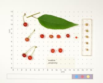 | | 1999 | DONATED | | | | | | Cultivar | | 1589513 | PI 638735 |
| 1 | GPRU 163 | MARSB-153 | Prunus maritima Marshall | Delaware, United States | GEN |  | | 2019 | | | | | | | Wild material | | 2097500 | GPRU 163 |
| 2 | GPRU 164 | MARSB-290 | Prunus maritima Marshall | New Jersey, United States | GEN |  | | 2019 | | | | | | | Wild material | | 2097559 | GPRU 164 |
| 3 | GPRU 168 | MARSB-577 | Prunus serotina Ehrh. | New York, United States | GEN |  | | 2019 | | | | | | | Wild material | | 2097661 | GPRU 168 |
| 4 | GPRU 160 | MARSB-576 | Prunus maritima Marshall | New York, United States | GEN |  | | 2018 | | | | | | | Wild material | | 1964799 | GPRU 160 |
| 5 | NA 88123 | MARSB-798 | Morella pensylvanica (Mirb.) Kartesz | New York, United States | NA |  | | 2019 | | | | | | | Wild material | | 2097709 | NA 88123 |
| 6 | NA 88033 | NCBG-403 | Morella pensylvanica (Mirb.) Kartesz | Virginia, United States | NA |  | | 2018 | | | | | | | Wild material | | 1965944 | NA 88033 |
| 7 | NA 87990 | MARSB-150 | Morella pensylvanica (Mirb.) Kartesz | Delaware, United States | NA |  | | 2018 | | | | | | | Wild material | | 1964723 | NA 87990 |
| 8 | NA 87995 | MARSB-224 | Morella pensylvanica (Mirb.) Kartesz | New York, United States | NA |  | | 2018 | | | | | | | Wild material | | 1964741 | NA 87995 |
| 9 | NA 87996 | MARSB-291 | Morella pensylvanica (Mirb.) Kartesz | New Jersey, United States | NA |  | | 2018 | | | | | | | Wild material | | 1964750 | NA 87996 |
| 10 | NA 87999 | MARSB-468 | Morella pensylvanica (Mirb.) Kartesz | New Jersey, United States | NA |  | | 2018 | | | | | | | Wild material | | 1964778 | NA 87999 |
| 11 | NA 88000 | MARSB-579 | Morella pensylvanica (Mirb.) Kartesz | New York, United States | NA |  | | 2018 | | | | | | | Wild material | | 1964800 | NA 88000 |
| 12 | NA 88001 | MARSB-595 | Morella pensylvanica (Mirb.) Kartesz | New York, United States | NA |  | | 2018 | | | | | | | Wild material | | 1964805 | NA 88001 |
| 13 | NA 88003 | MARSB-639 | Morella pensylvanica (Mirb.) Kartesz | Delaware, United States | NA |  | | 2018 | | | | | | | Wild material | | 1964813 | NA 88003 |
| 14 | Ames 38800 | Camp Mitigwa | Amelanchier arborea (F. Michx.) Fernald | Iowa, United States | NC7 |  | | 2026 | COLLECTED | 06/01/2026 | Mitigwa Scout Camp located on west side of Des Moines River watershed approximately 7.50 miles south, southwest of Boone, T82N R26W N 1/4 Sec. 5 and T83N R26W S 1/4 Sec. 32. | 41.94894500, -93.90537200 | 310 | High-quality white oak - ironwood, mature woods. | Wild material | The native range of Amelanchier arborea is concentrated in the eastern half of the U.S. (Little, 1977). This accession represents a collection of A. arborea germplasm from the western edge of the species native range, specifically central Iowa. Specimens sampled at the collection site in nature were small to medium understory or woodland edge single and/or multi-trunked trees with a few trees getting close to being deemed as canopy specimens. Bark smooth and light grey in color. Specimens sampled in nature ranging 15-50' in height. Peak flowering occurred on 8 April 2026 with white flowers appearing prior to leaf expansion. Fall colors ranging from orange to orange-red peaking typically at the end of September (central Iowa). Fruits, dark-pink to red, maturing in early June (peak in 2026 occurred on 2 June) averaging 8 mm in diameter, except for mother tree #6 that had rather large fruits at 11 mm in diameter. | 2197049 | Ames 38800 |
| 15 | W6 62512 | FWS0300-100 | Sporobolus cryptandrus (Torr.) A. Gray | Michigan, United States | W6 |  | | 2025 | | | | | | | Wild material | | 2192210 | W6 62512 |
| 16 | W6 62513 | FWS0300-102 | Sorghastrum nutans (L.) Nash | Michigan, United States | W6 |  | | 2025 | | | | | | | Wild material | Near active artillery range | 2192211 | W6 62513 |
| 17 | W6 62524 | FWS0300-120 | Liatris aspera Michx. | Michigan, United States | W6 |  | | 2025 | | | | | | | Wild material | | 2192222 | W6 62524 |
| 18 | W6 62526 | FWS0300-127 | Bromus kalmii A. Gray | Michigan, United States | W6 |  | | 2025 | | | | | | | Wild material | Near active artillery range. The above population size does not include vegetative plants. | 2192224 | W6 62526 |
| 19 | W6 62527 | FWS0300-130 | Solidago hispida Muhl. ex Willd. | Michigan, United States | W6 |  | | 2025 | | | | | | | Wild material | Received as: Solidago hispida | 2192225 | W6 62527 |
| 20 | W6 62538 | FWS0300-153 | Monarda punctata L. | Michigan, United States | W6 |  | | 2025 | | | | | | | Wild material | | 2192236 | W6 62538 |
| 21 | W6 62542 | FWS0300-66 | Danthonia spicata (L.) P. Beauv. ex Roem. & Schult. | Michigan, United States | W6 |  | | 2025 | | | | | | | Wild material | | 2192240 | W6 62542 |
| 22 | W6 62543 | FWS0300-67 | Avenella flexuosa (L.) Parl. | Michigan, United States | W6 |  | | 2025 | | | | | | | Wild material | | 2192241 | W6 62543 |
| 23 | W6 62546 | FWS0300-97 | Schizachyrium scoparium (Michx.) Nash | Michigan, United States | W6 |  | | 2025 | | | | | | | Wild material | There is Solidago vossii in the area. | 2192244 | W6 62546 |
| 24 | W6 62547 | FWS0300-98 | Andropogon gerardi Vitman | Michigan, United States | W6 |  | | 2025 | | | | | | | Wild material | There is Solidago vossii in the area. | 2192245 | W6 62547 |
| 25 | W6 62548 | FWS0300-99 | Elymus canadensis L. | Michigan, United States | W6 |  | | 2025 | | | | | | | Wild material | | 2192246 | W6 62548 |
| 26 | OPGC 8857 | Marietta Sand Prairie | Verbena stricta Vent. | Iowa, United States | OPGC | | | 2024 | COLLECTED | 09/04/2024 | Marietta Sand Prairie State Preserve located 7.5 miles northwest of Marshalltown on Knapp Avenue, T84N R19W SW ¼ Sec. 11. | 42.09711200, -93.03873400 | 297 | Remnant sand prairie. | Wild material | | 2170474 | OPGC 8857 |
| 27 | NA 88593 | 2024RJLNJ-001 | Ilex glabra (L.) A. Gray | New Jersey, United States | NA | | | 2024 | COLLECTED | 11/24/2024 | Mullica Township: Both sides of Duerer Street, approximately 0.37 kilometers southeast of 4th Avenue. | 39.55885000, -74.66442500 | 21 | Shade to almost full sun on compacted seasonally moist to temporarily wet areas of a mixed evergreen and deciduous woodland dominated by Pinus rigida. Vegetation of this area is very much defined by small changes in elevation that go from wet to very dry. Ilex glabra remains abundant throughout, though. Slope: N/A. Aspect: N/A. The underlying geology of this area is the Cohansey Formation of middle Miocene origin and comprised of sand, white to yellow with local gravel and clay. It is sometimes locally stained red or orange brown by iron oxides and (or) cemented into large blocks of ironstone. Unweathered clay is typically dark gray, but commonly weathers white where it is interbedded with thin beds of ironstone. Sand is typically medium grained and moderately sorted although it ranges from fine to very coarse grained and from poorly to well sorted. Sand consists of quartz and siliceous rock fragments. Some beds are locally micaceous. Maximum thickness in the map area is about 60 meters; however, thickness is difficult to determine because of the irregular basal contact and extensive post-depositional erosion. (Source: USGS New Jersey Geologic Map Data). The primary soil type in the area of this collection is classified as Mullica Series sandy loam, 0 to 2 percent slopes. These soils are typically coarse-loamy, siliceous, semiactive, and mesic typic humaquepts that are strongly to extremely acidic throughout the profile. The typical solum thickness ranges from 50-150+ cm. These soils are generally considered to be poorly drained. (Source: NRCS Web Soil Survey). | Wild material | | 2169930 | NA 88593 |
| 28 | NA 89080 | 2024RJLPA-006 | Ilex montana Torr. & A. Gray | Pennsylvania, United States | NA | | | 2024 | COLLECTED | 09/20/2024 | Berks and Schuylkill Counties: Hawk Mountain Sanctuary. | 40.64162200, -75.99122600 | 418 | Plants are growing from shade to full sun on a dry-mesic to very dry, well-drained upland/montane habitat characterized by an upland mixed deciduous and evergreen forest that is very rocky. All the plants found in this habitat go through periods of drought during the growing season due to the limited litter/soil layer in which moisture can be held. Elevation: 405 to 430 meters. Slope: 5 to 25 percent. Aspect: various. Geology: The underlying geology of this area is of Silurian origin and comprised of Shawangunk Formation. This formation is primarily light- to dark-gray, fine- to very coarse-grained sandstone and conglomerate containing thin shale interbeds. (Source: USGS Pennsylvania Geologic Map Data). Soils: The surface soil profile of this area is characterized as the Hazleton Series which consists of deep and very deep, well drained soils formed in residuum of acid gray, brown or red sandstone on uplands. The matrix includes a considerable accumulation of thin, flat, coarse fragments of sandstone, limestone, or schist with diameters up to 15 cm. Slope ranges from 0-80%. Permeability is moderately rapid to rapid. (Source: USDA-NRCS Official Soil Series Descriptions). EPA Ecoregion (Level III): Ridge and Valley (67). EPA Ecoregion (Level IV): Northern Sandstone Ridges (67c). | Wild material | | 2169044 | NA 89080 |
| 29 | OPGC 8803 | CBG- 10754 | Aquilegia canadensis L. | Illinois, United States | OPGC | | | 2023 | | | | | | | Wild material | | 2142225 | OPGC 8803 |
| 30 | OPGC 8813 | CBG- 10781 | Hieracium scabrum Michx. | Illinois, United States | OPGC | | | 2023 | | | | | | | Wild material | | 2142247 | OPGC 8813 |
| 31 | OPGC 8820 | CBG- 10801 | Apocynum androsaemifolium L. | Illinois, United States | OPGC | | | 2023 | | | | | | | Wild material | | 2142260 | OPGC 8820 |
| 32 | W6 61358 | CBG- 10772 | Carex cephalophora Muhl. ex Willd. | Wisconsin, United States | W6 |  | | 2023 | | | | | | | Wild material | | 2142240 | W6 61358 |
| 33 | WLP 2673 | RJL2022NJ-004 | Lyonia mariana (L.) D. Don | New Jersey, United States | NA | | | 2022 | COLLECTED | 10/24/2022 | Plants growing on both sides of Duerer Street approximately 0.37 kilometers southeast of 4th Avenue, Mullica Township, New Jersey. Plants are common but scattered on both sides of the road at this site. | 39.55730700, -74.66376100 | 22 | Plants grow from part shade to full sun throughout the habit from the upper edges of the ditches through the herbaceous grass dominant buffer and all the way to the part shade of the woodland edge. Plants transition through moist/wet conditions in full sun to quite dry conditions in part shade and seem equally adapted.
Soils: The underlying geology of this area is the Cohansey Formation of middle Miocene origin and comprised of sand, white to yellow with local gravel and clay. It is sometimes locally stained red or orange brown by iron oxides and (or) cemented into large blocks of ironstone. Unweathered clay is typically dark gray, but commonly weathers white where it is interbedded with thin beds of ironstone. Sand is typically medium grained and moderately sorted although it ranges from fine to very coarse grained and from poorly to well sorted. Sand consists of quartz and siliceous rock fragments. Some beds are locally micaceous. Maximum thickness in the map area is about 60 meters; however, thickness is difficult to determine because of the irregular basal contact and extensive post-depositional erosion.
Source: USGS New Jersey Geologic Map Data (https://mrdata.usgs.gov/geology/state/sgmc-unit.php?unit=NJTch%3B1)
The primary soil type in the area of this collection is classified as Mullica sandy loam, 0 to 2 percent slopes. These soils are typically coarse-loamy, siliceous, semiactive, and mesic typic humaquepts that are strongly to extremely acidic throughout the profile. The typical solum thickness ranges from 50-150+ cm. These soils are generally considered to be poorly drained.
Source: NRCS Web Soil Survey (https://websoilsurvey.sc.egov.usda.gov/App/WebSoilSurvey.aspx) | Wild material | | 2139664 | WLP 2673 |
| 34 | NA 88500 | RJL2022NJ-002 | Ilex glabra (L.) A. Gray | New Jersey, United States | NA | | | 2022 | COLLECTED | 10/24/2022 | Mullica Township: both sides of Duerer Street, approximately 0.37 kilometers southeast of 4th Avenue. | 39.55885000, -74.66442500 | 21 | Plants growing in shade to almost full sun on compacted seasonally moist to temporarily wet areas of a mixed evergreen and deciduous woodland dominated by Pinus rigida. Vegetation of this area is very much defined by small changes in elevation that go from wet to very dry. Ilex glabra remains abundant throughout, though. Plants are abundant on the edge of the woodlands as well as the understory of the woodlands. Soils: The underlying geology of this area is the Cohansey Formation of middle Miocene origin and comprised of sand, white to yellow with local gravel and clay. It is sometimes locally stained red or orange brown by iron oxides and (or) cemented into large blocks of ironstone. Unweathered clay is typically dark gray, but commonly weathers white where it is interbedded with thin beds of ironstone. Sand is typically medium grained and moderately sorted although it ranges from fine to very coarse grained and from poorly to well sorted. Sand consists of quartz and siliceous rock fragments. Some beds are locally micaceous. Maximum thickness in the map area is about 60 meters; however, thickness is difficult to determine because of the irregular basal contact and extensive post-depositional erosion. (Source: USGS New Jersey Geologic Map Data). The primary soil type in the area of this collection is classified as Mullica sandy loam, 0 to 2 percent slopes. These soils are typically coarse-loamy, siliceous, semiactive, and mesic typic humaquepts that are strongly to extremely acidic throughout the profile. The typical solum thickness ranges from 50-150+ cm. These soils are generally considered to be poorly drained. (Source: NRCS Web Soil Survey). | Wild material | | 2139663 | NA 88500 |
| 35 | NA 88489 | RJL2022PA-005 | Kalmia latifolia L. | Pennsylvania, United States | NA | | | 2022 | COLLECTED | 09/10/2022 | Plants are growing on the lands of Hawk Mountain Sanctuary. This species is very common and abundant. It is one of the most dominant understory plants in woodlands. This species is a common understory shrub throughout the entire region in upland dry woodland habitats. | 40.63862000, -75.99071200 | 430 | Plants are growing primarily in shade to part-shade on a dry-mesic to very dry, well-drained upland/montane habitat characterized by upland mixed deciduous and evergreen forest that is very rocky. All of the plants found in this habitat go through periods of drought during the growing season due to the limited litter/soil layer in which moisture can be held. The underlying geology of this area is of Silurian origin and comprised of Shawangunk Formation. This formation is primarily light- to dark-gray, fine- to very coarse-grained sandstone and conglomerate containing thin shale interbeds.
Source: USGS Pennsylvania Geologic Map Data (https://mrdata.usgs.gov/geology/state/sgmc-unit.php?unit=PASs%3B14)
The surface soil profile of this area is the Hazleton series consists of deep and very deep, well drained soils formed in residuum of acid gray, brown or red sandstone on uplands. The matrix includes a considerable accumulation of thin, flat, coarse fragments of sandstone, limestone, or schist with diameters up to 15 cm. Slope ranges from 0-80%. Permeability is moderately rapid to rapid.
Source: NRCS Web Soil Survey (https://websoilsurvey.sc.egov.usda.gov/App/WebSoilSurvey.aspx) | Wild material | | 2139368 | NA 88489 |
| 36 | NA 88490 | RJL2022PA-006 | Ilex montana Torr. & A. Gray | Pennsylvania, United States | NA | | | 2022 | COLLECTED | 09/10/2022 | Hawk Mountain Sanctuary. | 40.64162200, -75.99122600 | 420 | Plants are growing from shade to full sun on a dry-mesic to very dry, well-drained upland/montane habitat characterized by an upland mixed deciduous and evergreen forest that is very rocky. All of the plants found in this habitat go through periods of drought during the growing season due to the limited litter/soil layer in which moisture can be held. The underlying geology of this area is of Silurian origin and comprised of Shawangunk Formation. This formation is primarily light- to dark-gray, fine- to very coarse-grained sandstone and conglomerate containing thin shale interbeds. (Source: USGS Pennsylvania Geologic Map Data). The surface soil profile of this area is the Hazleton series consists of deep and very deep, well drained soils formed in residuum of acid gray, brown or red sandstone on uplands. The matrix includes a considerable accumulation of thin, flat, coarse fragments of sandstone, limestone, or schist with diameters up to 15 cm. Slope ranges from 0-80%. Permeability is moderately rapid to rapid. (Source: NRCS Web Soil Survey). | Wild material | | 2139369 | NA 88490 |
| 37 | NA 88491 | RJL2022PA-007 | Rhododendron maximum L. | Pennsylvania, United States | NA | | | 2022 | COLLECTED | 09/10/2022 | Plants are growing on the lands of Hawk Mountain Sanctuary. This species was common, but generally restricted to steep rocky outcrops. | 40.63813900, -75.98835200 | 420 | Plants are growing from shade to full sun on a dry-mesic to very dry, well-drained upland/montane habitat characterized by an upland mixed deciduous and evergreen forest that is very rocky. Even so, most heavily fruited plants were growing in part shade to almost full sun. All of the plants found in this habitat go through periods of drought during the growing season due to the limited litter/soil layer in which moisture can be held. The underlying geology of this area is of Silurian origin and comprised of Shawangunk Formation. This formation is primarily light- to dark-gray, fine- to very coarse-grained sandstone and conglomerate containing thin shale interbeds.
Source: USGS Pennsylvania Geologic Map Data (https://mrdata.usgs.gov/geology/state/sgmc-unit.php?unit=PASs%3B14)
The surface soil profile of this area is the Hazleton series consists of deep and very deep, well drained soils formed in residuum of acid gray, brown or red sandstone on uplands. The matrix includes a considerable accumulation of thin, flat, coarse fragments of sandstone, limestone, or schist with diameters up to 15 cm. Slope ranges from 0-80%. Permeability is moderately rapid to rapid.
Source: NRCS Web Soil Survey (https://websoilsurvey.sc.egov.usda.gov/App/WebSoilSurvey.aspx) | Wild material | | 2139370 | NA 88491 |
| 38 | OPGC 7587 | Marietta Sand Prairie | Packera plattensis (Nutt.) W. A. Weber & Á. Löve | Iowa, United States | OPGC |  | | 2022 | COLLECTED | 06/03/2022 | Marietta Sand Prairie State Preserve located 12.0 km northwest of Marshalltown and 10.0 km north of Highway 30 on Knapp Avenue, T84N R19W W ½ Sec. 11. | 42.09835700, -93.03457900 | 299 | Remnant sand prairie. | Wild material | Plants in nature are approximately one to two feet in height. Peak flower and fruiting in 2022 occurred on 26 May and 3 June, respectively. | 2138177 | OPGC 7587 |
| 39 | OPGC 8519 | MARSB-415 | Limonium carolinianum (Walter) Britton | New York, United States | OPGC | | | 2021 | | | | | | | Wild material | | 2137176 | OPGC 8519 |
| 40 | W6 60082 | MARSB-144 | Hudsonia tomentosa Nutt. | New Jersey, United States | W6 | | | 2021 | | | | | | | Wild material | Scale like leaves, blueish tint, yellow flowers. | 2137167 | W6 60082 |
| 41 | NA 86885 | RJL2021PA-004 | Ilex verticillata (L.) A. Gray | Pennsylvania, United States | NA | | | 2021 | COLLECTED | 11/16/2021 | Plants growing in woodlands along a small unnamed creek corridor dumping into the Middle Branch White Clay Creek in Goddard Park, West Grove Pennsylvania, off of Wickerton Road, Chester County. | 39.81063861, -75.82750806 | 124 | Plants are growing in a range of habitats from mesic woodlands to saturated streamside settings of deciduous woodlands that drain toward the Middle Branch White Clay Creek. Plants grow in high understory shade with dappled to indirect sunlight. The only female (fruiting) plants were found in areas along the creek where soils are moist to saturated. Numerous male specimens were found in the areas described above. Soils: Soils found in the areas where this collection was made are comprised primarily of Baile silt loam (Ba), Hatboro silt loam (Ha), and Glenelg silt loam, 8 to 15 percent slopes (GgC). Baile silt loam consists of very deep, poorly drained, moderately low to moderately high saturated hydraulic conductivity, soils on upland depressions and footslopes that were formed in local alluvium over residuum from acid crystalline rocks, chiefly mica schist and granitized schist and gneiss; slope ranges from 0 to 8 percent. Hatboro silt loam consists of very deep and poorly drained soils formed in deposited alluvium derived from metamorphic and crystalline rock. They are on flood plains. Slopes range from 0 to 3 percent. Glenelg silt loam, 8 to 15 percent slopes consists of very deep, well drained soils formed in residuum weathered from micaceous schist on uplands of the Blue Ridge and the Northern Piedmont. This soil is undifferentiated, mostly poorly drained sandy bottomland soils intermingled with decomposing organic litter and eroded silts and clays due to erosion. Slope: 0 to 15% Aspect: Variable. | Wild material | | 2123125 | NA 86885 |
| 42 | WLP 1731 | RJL2021PA-001 | Viburnum acerifolium L. | Pennsylvania, United States | NA | | | 2021 | COLLECTED | 11/05/2021 | Plants growing in woodlands above a small unnamed creek that dumps into the Middle Branch White Clay Creek in Goddard Park, West Grove Pennsylvania, off of Wickerton Road, Chester County. | 39.80462083, -75.82888750 | 103 | Plants growing in a mesic, well-drained habitat of deciduous woodlands, for the most part, above the riparian zone that drains toward a small unnamed creek that feeds into the Middle Branch White Clay Creek. Plants are growing in high understory shade with very little direct sun during most of the day. The remnant woodlands exist mostly along the steep slopes, wetlands and seeps of seasonal and year-round creeks flowing into the Middle Branch White Clay Creek. The woodlands are bordered by numerous housing developments and land converted to meadows; hence there is significant first order edge that is heavily impacted by invasive plant intrusion. Soils: Soils are classified as Glenelg silt loam, 8 to 15% slopes (GgC); this series consists of very deep, well drained soils formed in residuum weathered from micaceous schist on uplands of the Blue Ridge and the Northern Piedmont. Saturated hydraulic conductivity is moderately high in the subsoil and moderately high to high in the substratum. This upper horizon of this soil is undifferentiated, mostly poorly drained sandy bottomland soils intermingled with decomposing organic litter and eroded silts and clays due to erosion. Slope: 8 to 15% Aspect: West. | Wild material | | 2123080 | WLP 1731 |
| 43 | WLP 1732 | RJL2021PA-002 | Viburnum prunifolium L. | Pennsylvania, United States | NA | | | 2021 | COLLECTED | 11/05/2021 | Plants growing in woodlands along a small unnamed creek corridor dumping into the Middle Branch White Clay Creek in Goddard Park, West Grove Pennsylvania, off of Wickerton Road, Chester County. | 39.80462083, -75.82888750 | 102 | Plants are growing in a range of habitats from drier upland woods to moist creekside settings of deciduous woodlands that drain toward the Middle Branch White Clay Creek. Plants grow in part shade to high understory shade with dappled to indirect direct sunlight. Plants achieve their largest size and fruiting potential in part sun of the riparian zone of the creek where woodland canopy is thinner. Soils: Soils found in the areas where this collection was made are comprised primarily of flood plain Hatboro silt loam (Ha) and well-drained, upland Glenelg silt loam, 8 to 15 percent slopes (GgC). Hatboro silt loam consists of very deep and poorly drained soils formed in deposited alluvium derived from metamorphic and crystalline rock. They are on flood plains. Slopes range from 0 to 3 percent. Glenelg silt loam, 8 to 15 percent slopes consists of very deep, well drained soils formed in residuum weathered from micaceous schist on uplands of the Blue Ridge and the Northern Piedmont. This soil is undifferentiated, mostly poorly drained sandy bottomland soils intermingled with decomposing organic litter and eroded silts and clays due to erosion. Slope: 0 to 15% Aspect: Variable. | Wild material | | 2123098 | WLP 1732 |
| 44 | WLP 1733 | RJL2021PA-003 | Viburnum dentatum L. | Pennsylvania, United States | NA | | | 2021 | COLLECTED | 11/05/2021 | Plants growing in woodlands along a small unnamed creek corridor dumping into the Middle Branch White Clay Creek in Goddard Park, West Grove Pennsylvania, off of Wickerton Road, Chester County. | 39.80522167, -75.82928139 | 107 | Plants are growing in a range of habitats from mesic woodland to moist creekside settings of deciduous woodlands that drain toward the Middle Branch White Clay Creek. Plants grow in high understory shade with dappled to indirect sunlight. Soils: Soils found in the areas where this collection was made are comprised primarily of flood plain Hatboro silt loam (Ha) and well-drained, upland Glenelg silt loam, 8 to 15 percent slopes (GgC). Hatboro silt loam consists of very deep and poorly drained soils formed in deposited alluvium derived from metamorphic and crystalline rock. They are on flood plains. Slopes range from 0 to 3 percent. Glenelg silt loam, 8 to 15 percent slopes consists of very deep, well drained soils formed in residuum weathered from micaceous schist on uplands of the Blue Ridge and the Northern Piedmont. This soil is undifferentiated, mostly poorly drained sandy bottomland soils intermingled with decomposing organic litter and eroded silts and clays due to erosion. Slope: 0 to 15% Aspect: Variable. | Wild material | | 2123124 | WLP 1733 |
| 45 | W6 58574 | MARSB-176 | Cyperus grayi Torr. | Delaware, United States | W6 | | | 2021 | | | | | | | Wild material | Inflorescence looks like fireworks, bulbous root growths. Grows in clumps. | 2113504 | W6 58574 |
| 46 | W6 58628 | MARSB-553 | Avenella flexuosa (L.) Parl. | New York, United States | W6 | | | 2021 | | | | | | | Wild material | Round stem, inflorescence with thin wiry branches and tan seed. Large tufts of straight, wiry basal leaves. | 2113558 | W6 58628 |
| 47 | W6 58631 | MARSB-580 | Cyperus grayi Torr. | New York, United States | W6 | | | 2021 | | | | | | | Wild material | Triangular stem, branches fork from one point at the top of the stem, flat, feather-like inflorescences, bulbous root nodules. | 2113561 | W6 58631 |
| 48 | NA 88106 | MARSB-412 | Baccharis halimifolia L. | New York, United States | NA |  | | 2019 | | | | | | | Wild material | | 2097620 | NA 88106 |
| 49 | NA 88125 | MARSB-875 | Juniperus virginiana L. | New Jersey, United States | NA |  | | 2019 | | | | | | | Wild material | | 2097745 | NA 88125 |
| 50 | NA 88440 | MARSB-419 | Rosa virginiana Mill. | New York, United States | NA |  | | 2019 | | | | | | | Wild material | | 2097623 | NA 88440 |
| 51 | W6 57056 | MARSB-138 | Avenella flexuosa (L.) Parl. | New York, United States | W6 |  | | 2019 | | | | | | | Wild material | | 2097495 | W6 57056 |
| 52 | W6 57057 | MARSB-140 | Hudsonia tomentosa Nutt. | New York, United States | W6 |  | | 2019 | | | | | | | Wild material | | 2097496 | W6 57057 |
| 53 | W6 57083 | MARSB-212 | Carex silicea Olney | New York, United States | W6 |  | | 2019 | | | | | | | Wild material | | 2097522 | W6 57083 |
| 54 | W6 57086 | MARSB-223 | Cyperus grayi Torr. | New York, United States | W6 |  | | 2019 | | | | | | | Wild material | | 2097525 | W6 57086 |
| 55 | W6 57124 | MARSB-300 | Cyperus grayi Torr. | New Jersey, United States | W6 | 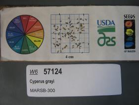 | | 2019 | | | | | | | Wild material | | 2097563 | W6 57124 |
| 56 | W6 57139 | MARSB-329 | Hexasepalum teres (Walter) J. H. Kirkbr. | New Jersey, United States | W6 |  | | 2019 | | | | | | | Wild material | | 2097578 | W6 57139 |
| 57 | W6 57182 | MARSB-416 | Parthenocissus quinquefolia (L.) Planch. | New York, United States | W6 |  | | 2019 | | | | | | | Wild material | | 2097621 | W6 57182 |
| 58 | W6 57183 | MARSB-418 | Pseudognaphalium obtusifolium (L.) Hilliard & B. L. Burtt | New York, United States | W6 |  | | 2019 | | | | | | | Wild material | | 2097622 | W6 57183 |
| 59 | Ames 34781 | MARSB-594 | Rhus copallinum L. | New York, United States | NC7 |  | | 2018 | COLLECTED | 09/20/2016 | Brooklyn Marine Park just off Gerritsen Avenue. | 40.59222000, -73.91822000 | 2 | Maritime successional forest | Wild material | | 1964804 | Ames 34781 |
| 60 | NA 87998 | MARSB-417 | Baccharis halimifolia L. | New York, United States | NA |  | | 2018 | | | | | | | Wild material | | 1964771 | NA 87998 |
| 61 | OPGC 6539 | MARSB-445 | Solidago sempervirens L. | New Jersey, United States | OPGC |  | | 2018 | | | | | | | Wild material | Solidago sempervirens | 1964772 | OPGC 6539 |
| 62 | W6 54020 | MARSB-211 | Juncus gerardi Loisel. | New York, United States | W6 |  | | 2018 | | | | | | | Wild material | Juncus gerardii | 1964736 | W6 54020 |
| 63 | W6 54027 | MARSB-232 | Schoenoplectus pungens (Vahl) Palla | New York, United States | W6 |  | | 2018 | | | | | | | Wild material | Schoenoplectus pungens | 1964743 | W6 54027 |
| 64 | Ames 34780 | MARSB-396 | Rhus copallinum L. | New York, United States | NC7 |  | | 2017 | COLLECTED | 11/03/2015 | Jones Beach State Park (Field 6). | 40.61213000, -73.42044000 | 3 | Atlantic coastal beach, north Atlantic coastal shrub and grass dune | Wild material | | 1954643 | Ames 34780 |
| 65 | WLP 1984 | MARSB-809 | Viburnum dentatum L. | New York, United States | NA | | | 2017 | COLLECTED | 08/24/2017 | Suffolk County; ; Hither Hills State Park: Cemetery Road & Old Montauk Highway. | 41.00577000, -72.02097000 | | Mid-succession scrubland; roadside. Sand soil (Dune Land, Montauk Loam). Land used for conservation and recreation. | Wild material | Seeds collected from 80 plants; 100 plants found in an area of three acres. Two herbarium vouchers collected on 24 Aug. 2017; held at Smithsonian and MARSB. Material identified in field by Clara Holmes on 24 Nov. 2017. Ecoregion: 84E -- Atlantic Coastal Pine Barrens (Omernik). | 2108828 | WLP 1984 |
| 66 | Ames 34014 | Ames 34014 | Aronia melanocarpa (Michx.) Elliott | Illinois, United States | NC7 |  | | 2017 | COLLECTED | 09/03/2017 | Nachusa Grasslands - locally known as Coyote Point approximately 3.80 miles northwest of Franklin Grove just 0.60 miles west of Lowden Road, T22N R10E NE 1/4 NE 1/4 SW 1/4 Sec. 21, Lee County | 41.87972200, -89.35305600 | 220 | St. Peter's sandstone cliff, specimens noted on ridgetop and on slopes. | Wild material | This accession based on morphological/phenological observations at NCRPIS field plots seems to represent the "southern form" of A. melanocarpa, potentially a new Aronia species. This southern form was originally discovered by Brand et al. 2022 (Ploidy, genetic diversity and speciation of the genus Aronia) and is known for having glabrous stems and leaves and a distinct phyllotaxy than other Aronia species. In addition, plants tend to bloom approximately two weeks later than all other Aronia taxonomic groups and the inflorescences/infructescences are more spreading and extended due to longer peduncles and pedicels within the cyme. Fruit maturity tends to occur 2 to 4 weeks later than tetraploid A. melanocarpa and 4 to 6 weeks later than diploid A. melanocarpa. Phenolic levels are much higher in comparison to other A. melanocarpa accessions (Brand et al., 2017 - Anthocyanins, total phenolics, ORAC and moisture content of wild and cultivated dark-fruited Aronia species.) | 1953928 | Ames 34014 |
| 67 | W6 48847 | MARSB-054 | Avenella flexuosa (L.) Parl. | New York, United States | W6 |  | | 2015 | | | | | | | Wild material | | 1922854 | W6 48847 |
| 68 | Ames 32835 | GA14014001 | Fraxinus pennsylvanica Marshall | North Dakota, United States | NC7 |  | | 2014 | COLLECTED | 10/30/2014 | Bottineau County, Turtle Mountains. | 48.97000000, -100.45000000 | 737 | Mixed oak-aspen forest | Wild material | | 1921828 | Ames 32835 |
| 69 | WLP 1746 | Ames 32838 | Viburnum opulus L. var. americanum Aiton | North Dakota, United States | NA | | | 2014 | COLLECTED | 10/31/2014 | Turtle Mountains - Bottineau County. | 48.95000000, -100.43000000 | 692 | Wet, aspen forest. Growing in association with Sanicula marilandica, Fragaria virginiana, Trifolium repens, Rubus sp., Typha latifolia, Prunus pensylvanica, Prunus virginiana, Corylus sp., Crataegus sp., Viburnum lentago, Rosa sp., Cornus sericea, Amelanchier sp., Symphoricarpos sp., Salix sp., Betula papyrifera, Populus tremuloides, Ulmus americana, Acer negundo, Quercus macrocarpa, and Fraxinus pennsylvanica. | Wild material | | 1921831 | WLP 1746 |
| 70 | Ames 32096 | BA13009001 | Fraxinus nigra Marshall | Minnesota, United States | NC7 |  | | 2013 | COLLECTED | 09/23/2013 | T144N R38W, Clearwater County. | 47.25711000, -95.49000667 | 543 | Edges of lakes and forest edges. Growing in association with Fraxinus pennsylvanica, Quercus macrocarpa, Ulmus americana, Populus tremuloides, Populus balsamifera, Acer saccharum, Betula papyrifera, Salix sp., Larix laricina, Quercus rubra, Abies balsamea, Picea glauca, Sambucus canadensis, Cornus rugosa, Acer spicatum, Rosa sp., Viburnum opulus var. americanum, Viburnum dentatum, Alnus sp., Cornus canadensis, Corylus sp., Prunus virginiana, Ribes sp., Prunus pensylvanica, Rhamnus alnifolia, Equisetum sp., Carex sp., Rubus sp., Impatiens capensis, Bromus sp., and Thalictrum dasycarpum. | Wild material | D.B.H. ranged between 3 and 6 inches. | 1914713 | Ames 32096 |
| 71 | Ames 31677 | GA12001001 | Fraxinus pennsylvanica Marshall | Minnesota, United States | NC7 |  | | 2012 | COLLECTED | 09/24/2012 | Southwest Becker County near Lake Cormorant and Lake Maud.. | 46.73903330, -95.97883330 | 415 | Edge of slough and forest. | Wild material | | 1906588 | Ames 31677 |
| 72 | Ames 31074 | 697 | Fraxinus americana L. | New York, United States | NC7 |  | | 2011 | COLLECTED | 09/13/2011 | Two Mile Road, Allegany County. | 42.03800000, -78.46400000 | 524 | | Wild material | | 1891460 | Ames 31074 |
| 73 | NA 70422 | MWPCC00-078 | Magnolia acuminata (L.) L. | North Carolina, United States | NA | | | 2000 | COLLECTED | 09/14/2000 | Blue Ridge Parkway pullover, N of marker 417. | 35.32333333, -82.82694444 | 1353 | Just in from mowed roadside. Slope: 15 degrees, Aspect: East, 3/4 day sun, Soil Type: gritty loam, well-drained, moist bottom of slope. | Wild material | | 1608250 | NA 70422 |