| 0 | NA 85007 | JDC/QB/2008/079/149 [related collection number] | Quercus bicolor Willd. | Iowa, United States | NA | | | 2018 | COLLECTED | 09/24/2015 | Chichaqua Wildlife Habitat Park bottoms, near Elkhart, NW 1/4 of NW 1/4 of Section 32, T81N, R22W, Loring Quad. | 41.79000000, -93.43972222 | 247 | | Wild material | Seedlings from seed collected at the same site as NA 81010, which was received in 2012 under collection number JDC/QB/2008/079/149, and also as Ames 29670. GRIN narrative: "A small proportion of seedlings during growout were noted to be Q. bicolor x Q. macrocarpa hybrids." Digital photographs of source trees available in GRIN under NA 85010/Ames 29670. | 2141805 | NA 85007 |
| 1 | NA 81010 | JDC/QB/2008/079/149 | Quercus bicolor Willd. | Iowa, United States | NA |  | | 2008 | COLLECTED | 10/21/2008 | Chichaqua Wildlife Habitat Park bottoms, near Elkhart, NW 1/4 of NW 1/4 of Section 32, T81N, R22W, Loring Quad, Polk County. | 41.79000000, -93.43972222 | 247 | | Wild material | A couple of specimens are approximately 300 years in age. Very large mature specimens, approximately 70-90 feet in height and 4-5 feet d.b.h. Largest specimen sampled was 54.5" d.b.h. A small proportion of seedlings during grow out were noted to be Q. bicolor x Q. macrocarpa hybrids. | 1788225 | NA 81010 |
| 2 | NA 77491 | NA 77491 | Quercus bicolor Willd. | Virginia, United States | NA | | | 2008 | COLLECTED | 09/2005 | South of Fancy Gap, near rest area of I-77. | | | | Wild material | | 1895985 | NA 77491 |
| 3 | NA 66677 | MORT 63 | Quercus bicolor Willd. | Iowa, United States | NA | | | 1992 | COLLECTED | PRE 05/15/1992 | Iowa, Des Moines | | | | Wild material | | 1643591 | NA 66677 |
| 4 | NA 86080 | NA 86080 | Quercus lyrata Walter | Maryland, United States | NA | | | 2019 | COLLECTED | 10/10/2019 | Prince George's County; ; Patuxent Wildlife Refuge, Shaver Farm Road off 197 west of Bowie State College. | 39.02805000, -76.77652000 | | | Wild material | | 2109127 | NA 86080 |
| 5 | WLP 1456 | HLJ090 | Lespedeza bicolor Turcz. | Heilongjiang Sheng, China | NA | | | 1993 | COLLECTED | 09/13/1993 | Rocky cliff above Jingpo Lake. [originally listed as Jian Shan Jiao; unable to verify place name. -SBL] | | 340 | Scrub community on rocky cliff above lake. | | | 1951972 | WLP 1456 |
| 6 | PI 664869 | JDC/HP/2008/030/100 | Hypericum prolificum L. | Missouri, United States | NC7 |  | | 2008 | COLLECTED | 10/06/2008 | Rudolf Bennitt Conservation Area, NE 1/4 of NE 1/4 of Section 25, T52N, R14W, Renick Quad, Randolph County. | 39.27527778, -92.43388889 | 256 | | Wild material | | 1788211 | PI 664869 |
| 7 | WLP 3658 | TRx250704-01NY | Lonicera morrowii A. Gray | New York, United States | NA | | | 2025 | COLLECTED | 07/04/2025 | | 43.31284000, -78.49509400 | | Edge of disturbed forest | Wild material | | 2191634 | WLP 3658 |
| 8 | NA 89081 | 2024RJLPA-009 | Rosa carolina L. | Pennsylvania, United States | NA | | | 2024 | COLLECTED | 09/22/2024 | Lancaster and York Counties: outcrops along the Susquehanna River, accessed from the Historic Lock 12 parking lot off of Pennsylvania Road 372. | 39.81483500, -76.32762200 | 34 | Plants are growing from part-sun to full sun in crevices of the outcrops and where organic debris has accumulated in between boulders along the Susquehanna River. The sites range from nearly xeric to dry mesic, at least on the surface. Plants are generally growing 4-10 m above the normal flow of the river; however, the Holtwood Dam is less than 1 kilometer upstream and debris found trapped in the boulders indicates that there is periodic flooding, at least, in the lower zone of 4+ meters or so above normal river flow. This habitat has a diverse assemblage of deciduous trees and shrubs as well as abundant herbaceous taxa. Slope: 0 to 60 percent. Aspect: Northeast (generally). Geology: The underlying geology of this area is probably of lower Paleozoic age and characterized as the Octoraro Formation. It includes albite-chlorite schist, phyllite, some hornblende gneiss, and granitized members. Soils: The area where this species occurs is right on the edge of two soil zones that transition from the river’s edge to mesic conditions upslope. The first is generally referred to as Rock Outcrop. This terrestrial matrix in which plants grow is largely exposed underlying rock geology with accumulated outwash, rock decomposition, and organic debris buildup. The second is Mt. Airy (80%) and Manor (20%) Series soils, 25 to 60 percent slopes, extremely stony (MRF). (Source: California Soil Resource Lab/NRCS Official Soil Series Descriptions). EPA Ecoregion (Level III): Northern Piedmont (64). EPA Ecoregion (Level IV): Piedmont Uplands (64c). | Wild material | | 2169045 | NA 89081 |
| 9 | NA 89082 | 2024RJLPA-010 | Amorpha fruticosa L. | Pennsylvania, United States | NA | | | 2024 | COLLECTED | 09/22/2024 | Outcrops along the Susquehanna River, accessed from the Historic Lock 12 parking lot off of Pennsylvania Road 372. | 39.81481500, -76.32757900 | 34 | Plants are growing from part-sun to full sun in crevices of the outcrops and where organic debris has accumulated in between boulders along the Susquehanna River. The sites range from nearly xeric to dry mesic, at least on the surface. Plants are generally growing 4-10 m above the normal flow of the river; however, the Holtwood Dam is less than 1 kilometer upstream and debris found trapped in the boulders indicates that there is periodic flooding, at least, in the lower zone of 4+ meters or so above normal river flow. This habitat has a diverse assemblage of deciduous trees and shrubs as well as abundant herbaceous taxa. Slope: 0 to 25 percent. Aspect: Northeast (generally). Geology: The underlying geology of this area is probably of lower Paleozoic age and characterized as the Octoraro Formation. It includes albite-chlorite schist, phyllite, some hornblende gneiss, and granitized members. Soils: The area where this species occurs is right on the edge of two soil zones that transition from the river’s edge to mesic conditions upslope. The first is generally referred to as Rock Outcrop. This terrestrial matrix in which plants grow is largely exposed underlying rock geology with accumulated outwash, rock decomposition, and organic debris buildup. The second is Mt. Airy (80%) and Manor (20%) Series soils, 25 to 60 percent slopes, extremely stony (MRF). (Source: California Soil Resource Lab/NRCS Official Soil Series Descriptions). EPA Ecoregion (Level III): Northern Piedmont (64). EPA Ecoregion (Level IV): Piedmont Uplands (64c). | Wild material | | 2169046 | NA 89082 |
| 10 | NA 89083 | 2024RJLPA-012 | Rhododendron periclymenoides (Michx.) Shinners | Pennsylvania, United States | NA | | | 2024 | COLLECTED | 09/22/2024 | Outcrops along the Susquehanna River, accessed from the Historic Lock 12 parking lot off of Pennsylvania Road 372. | 39.81477400, -76.32807300 | 35 | Plants are growing from shade to part-sun and occasionally full sun in crevices of the outcrops and where organic debris has accumulated in between boulders along the Susquehanna River. The sites range from nearly xeric to mesic, at least on the surface. Plants are generally growing 4-10 m above the normal flow of the river; however, the Holtwood Dam is less than 1 kilometer upstream and debris found trapped in the boulders indicates that there is periodic flooding, at least, in the lower zone of 4+ meters or so above normal river flow. This habitat has a diverse assemblage of deciduous trees and shrubs as well as abundant herbaceous taxa. Slope: 0 to 60 percent. Aspect: Northeast (generally). Geology: The underlying geology of this area is probably of lower Paleozoic age and characterized as the Octoraro Formation. It includes albite-chlorite schist, phyllite, some hornblende gneiss, and granitized members. Soils: The area where this species occurs is right on the edge of two soil zones that transition from the river’s edge to mesic conditions upslope. The first is generally referred to as Rock Outcrop. This terrestrial matrix in which plants grow is largely exposed underlying rock geology with accumulated outwash, rock decomposition, and organic debris buildup. The second is Mt. Airy (80%) and Manor (20%) Series soils, 25 to 60 percent slopes, extremely stony (MRF). (Source: California Soil Resource Lab/NRCS Official Soil Series Descriptions). EPA Ecoregion (Level III): Northern Piedmont (64). EPA Ecoregion (Level IV): Piedmont Uplands (64c). | Wild material | | 2169047 | NA 89083 |
| 11 | NA 89084 | 2024RJLPA-013 | Physocarpus opulifolius (L.) Maxim. | Pennsylvania, United States | NA | | | 2024 | COLLECTED | 09/22/2024 | Outcrops along the Susquehanna River, accessed from the Historic Lock 12 parking lot off of Pennsylvania Road 372. | 39.81466300, -76.32833900 | 36 | Plants are growing from shade to part-sun where organic debris has accumulated in between boulders as well as further upslope in deeper mesic soils along the Susquehanna River. This habitat has a diverse assemblage of deciduous trees and shrubs as well as abundant herbaceous taxa. Slope: 10 to 25 percent. Aspect: Northeast (generally). Geology: The underlying geology of this area is probably of lower Paleozoic age and characterized as the Octoraro Formation. It includes albite-chlorite schist, phyllite, some hornblende gneiss, and granitized members. Soils: The area where this species occurs is right on the edge of two soil zones that transition from the river’s edge to mesic conditions upslope. The first is generally referred to as Rock Outcrop. This terrestrial matrix in which plants grow is largely exposed underlying rock geology with accumulated outwash, rock decomposition, and organic debris buildup. The second is Mt. Airy (80%) and Manor (20%) Series soils, 25 to 60 percent slopes, extremely stony (MRF). (Source: California Soil Resource Lab/NRCS Official Soil Series Descriptions). EPA Ecoregion (Level III): Northern Piedmont (64). EPA Ecoregion (Level IV): Piedmont Uplands (64c). | Wild material | | 2169048 | NA 89084 |
| 12 | NA 89085 | 2024RJLPA-014 | Rhododendron arborescens (Pursh) Torr. | Pennsylvania, United States | NA | | | 2024 | COLLECTED | 09/22/2024 | Outcrops along the Susquehanna River, accessed from the Historic Lock 12 parking lot off of Pennsylvania Road 372. | 39.81618100, -76.33069800 | 38 | Plants are growing from shade to part-sun and occasionally full sun in crevices of the outcrops and where organic debris has accumulated in between boulders along the Susquehanna River. The sites range from nearly xeric to mesic, at least on the surface. Plants are generally growing 4-10 m above the normal flow of the river; however, the Holtwood Dam is less than 1 kilometer upstream and debris found trapped in the boulders indicates that there is periodic flooding, at least, in the lower zone of 4+ meters or so above normal river flow. This habitat has a diverse assemblage of deciduous trees and shrubs as well as abundant herbaceous taxa. Slope: 0 to 75 percent. Aspect: Northeast (generally). Geology: The underlying geology of this area is probably of lower Paleozoic age and characterized as the Octoraro Formation. It includes albite-chlorite schist, phyllite, some hornblende gneiss, and granitized members. Soils: The area where this species occurs is right on the edge of two soil zones that transition from the river’s edge to mesic conditions upslope. The first is generally referred to as Rock Outcrop. This terrestrial matrix in which plants grow is largely exposed underlying rock geology with accumulated outwash, rock decomposition, and organic debris buildup. The second is Mt. Airy (80%) and Manor (20%) Series soils, 25 to 60 percent slopes, extremely stony (MRF). (Source: California Soil Resource Lab/NRCS Official Soil Series Descriptions). EPA Ecoregion (Level III): Northern Piedmont (64). EPA Ecoregion (Level IV): Piedmont Uplands (64c). | Wild material | | 2169049 | NA 89085 |
| 13 | NA 89086 | 2024RJLPA-015 | Ilex verticillata (L.) A. Gray | Pennsylvania, United States | NA | | | 2024 | COLLECTED | 09/22/2024 | Outcrops along the Susquehanna River, accessed from the Historic Lock 12 parking lot off of Pennsylvania Road 372. | 39.81656600, -76.33136600 | 38 | Plants are growing from part-sun to full sun in crevices of the outcrops and where organic debris has accumulated in between boulders along the Susquehanna River. The sites range from nearly xeric to dry mesic, at least on the surface. Plants are generally growing 4-10 m above the normal flow of the river; however, the Holtwood Dam is less than 1 kilometer upstream and debris found trapped in the boulders indicates that there is periodic flooding, at least, in the lower zone of 4+ meters or so above normal river flow. This habitat has a diverse assemblage of deciduous trees and shrubs as well as abundant herbaceous taxa. Slope: 0 to 10 percent. Aspect: Northeast (generally). Geology: The underlying geology of this area is probably of lower Paleozoic age and characterized as the Octoraro Formation. It includes albite-chlorite schist, phyllite, some hornblende gneiss, and granitized members. Soils: The area where this species occurs is right on the edge of two soil zones that transition from the river’s edge to mesic conditions upslope. The first is generally referred to as Rock Outcrop. This terrestrial matrix in which plants grow is largely exposed underlying rock geology with accumulated outwash, rock decomposition, and organic debris buildup. The second is Mt. Airy (80%) and Manor (20%) Series soils, 25 to 60 percent slopes, extremely stony (MRF). (Source: California Soil Resource Lab/NRCS Official Soil Series Descriptions). EPA Ecoregion (Level III): Northern Piedmont (64). EPA Ecoregion (Level IV): Piedmont Uplands (64c). | Wild material | | 2169050 | NA 89086 |
| 14 | W6 61511 | CA180-281 | Collinsia heterophylla Graham | California, United States | W6 |  | | 2024 | | | | | | | | | 2167610 | W6 61511 |
| 15 | W6 60922 | CA160-21 | Amsinckia menziesii (Lehm.) A. Nelson & J. F. Macbr. | California, United States | W6 | 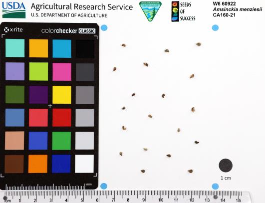 | | 2023 | | | | | | | Wild material | Big population on hillside, mostly dried this time of year | 2142560 | W6 60922 |
| 16 | W6 60935 | CA160-35 | Chorizanthe membranacea Benth. | California, United States | W6 |  | | 2023 | | | | | | | Wild material | Ready to collect. Stems hold on to seeds, either wind dispersed or by attachment. One seed per flower, which is about 10 seeds per fruiting head on average. Along side of road on very dry exposed soil. | 2142573 | W6 60935 |
| 17 | NA 89039 | RJL2022IL-001 | Ptelea trifoliata L. | Illinois, United States | NA | | | 2022 | COLLECTED | 09/28/2022 | Site of plant habitat is located at 823 E Co Rd 1220, Hamilton, IL 62341 which is the property where Jacob's Geode Shop and Mine is located. This species is scattered and relatively common throughout the woodlands on this site. | 40.37848400, -91.35390200 | 175 | Plants growing in shade to part-shade of deciduous woodlands above a small creek.
Soils: The underlying geology of this area is of Mississippian origin and comprised of Warsaw Formation and Salem Limestone. Major lithological components include limestone that can be shaly, oolitic, bioclastic, or cherty. Minor lithological components include siltstone that can contain geodes or drusy quartz and can be calcareous.
Source: USGS Illinois Geologic Map Data (https://mrdata.usgs.gov/geology/state/sgmc-unit.php?unit=ILMws%3B0)
The surface soil profile of this area is Coffeen silt loam, 0 to 2 percent slopes, that are frequently flooded. The Coffeen series consists of very deep, somewhat poorly drained, moderately permeable soils on flood plains, low terraces or benches, toe slopes, and alluvial fans. They formed in silty alluvium. Much of the alluvium is of local origin derived from the nearby loess-covered uplands.
Source: NRCS Web Soil Survey (https://websoilsurvey.sc.egov.usda.gov/App/WebSoilSurvey.aspx) | Wild material | | 2139604 | NA 89039 |
| 18 | Ames 35926 | AS/FN/2022/077/208 | Fraxinus nigra Marshall | Wisconsin, United States | NC7 |  | | 2022 | COLLECTED | 09/30/2022 | Approximately eight miles north-northeast of Cumberland at county line with Washburn County (collected on both sides of county line). Coordinates listed refer to the first plant sampled; coordinates for each specimen may be provided upon request. T36N R13W Sec. 3. | 45.63936700, -91.95952900 | 406 | Northern hardwood forest. | Wild material | | 2139689 | Ames 35926 |
| 19 | Ames 35884 | AS/MR/2022/003/133 | Morus rubra L. | Iowa, United States | NC7 |  | | 2022 | COLLECTED | 07/06/2022 | Chichaqua Bottoms Greenbelt located northeast of Bondurant, T81N R22W Sec. 33 and also T80N R22W Sec. 10. | 41.78917100, -93.41777300 | 247 | Floodplain. | Wild material | Specimens sampled in nature displayed the following morphological characters: elongated acuminate leaf tips, impressed veins, pubescent upper and lower leaves, flaky bark (often with tiny pin holes (insect emergence holes)), cordate leaf base, and umbrella-shaped growth habit. Majority of specimens were approximately 30-50' in height with the largest diameter specimen (133-6) measuring 19.5" DBH. All M. rubra specimens noted were exhibiting determinate growth compared to local hybrids and M. alba, which were still actively growing with newly emerging leaves. Soluble solids content for fruit samples collected in nature ranged from 12.8-22.8 degrees Brix. This range of Brix values is likely a result of genetic diversity and also variation in maturity of fruits. The highest Brix value was from specimen 133-4. | 2138217 | Ames 35884 |
| 20 | OPGC 8485 | CBG-10693 | Ludwigia polycarpa Short & R. Peter | Illinois, United States | OPGC | | | 2021 | | | | | | | Wild material | | 2132541 | OPGC 8485 |
| 21 | W6 59936 | CBG-10659 | Carex crus-corvi Shuttlew. | Illinois, United States | W6 | | | 2021 | | | | | | | Wild material | | 2132515 | W6 59936 |
| 22 | W6 59939 | CBG-10662 | Carex crus-corvi Shuttlew. | Illinois, United States | W6 |  | | 2021 | | | | | | | Wild material | | 2132518 | W6 59939 |
| 23 | OPGC 8369 | CA180-219 | Clarkia purpurea (Curtis) A. Nelson & J. F. Macbr. subsp. quadrivulnera (Douglas ex Lindl.) F. H. Lewis & M. E. Lewis | California, United States | OPGC | | | 2021 | | | | | | | Wild material | Petals purple to wine red often with a contrasting purple spot in center or edge but highly variable | 2120360 | OPGC 8369 |
| 24 | W6 59308 | CA180-222 | Brodiaea elegans Hoover | California, United States | W6 | | | 2021 | | | | | | | Wild material | Flower tube funnel shaped, violet, ascending; tips recurved. Staminodesûheld away from stamens which are flat and white. Three chambered fruit not split when ripe. Tiny black seeds. û | 2120363 | W6 59308 |
| 25 | W6 59171 | CBG-10456 | Carex annectens (E. P. Bicknell) E. P. Bicknell | Illinois, United States | W6 | | | 2021 | | | | | | | Wild material | | 2120093 | W6 59171 |
| 26 | W6 59177 | CBG-10464 | Carex normalis Mack. | Illinois, United States | W6 | | | 2021 | | | | | | | Wild material | | 2120098 | W6 59177 |
| 27 | W6 59181 | CBG-10472 | Carex muskingumensis Schwein. | Illinois, United States | W6 | | | 2021 | | | | | | | Wild material | | 2120102 | W6 59181 |
| 28 | W6 57055 | MARSB-130 | Danthonia spicata (L.) P. Beauv. ex Roem. & Schult. | New Jersey, United States | W6 |  | | 2019 | | | | | | | Wild material | | 2097494 | W6 57055 |
| 29 | NA 87967 | CBG-8082 | Cephalanthus occidentalis L. | Illinois, United States | NA |  | | 2017 | | | | | | | Wild material | | 1954783 | NA 87967 |
| 30 | OPGC 6391 | CBG-7403 | Lobelia cardinalis L. | Washington, United States | OPGC |  | | 2017 | | | | | | | Wild material | | 1954824 | OPGC 6391 |
| 31 | OPGC 7773 | CBG-7497 | Eutrochium maculatum (L.) E. E. Lamont | Wisconsin, United States | OPGC |  | | 2017 | | | | | | | Wild material | | 1954809 | OPGC 7773 |
| 32 | OPGC 7775 | CBG-7498 | Helenium autumnale L. | Wisconsin, United States | OPGC |  | | 2017 | | | | | | | Wild material | | 1954812 | OPGC 7775 |
| 33 | Ames 33358 | 730-1 | Betula nigra L. | Illinois, United States | NC7 |  | | 2016 | COLLECTED | 06/07/2016 | Momence wetlands - Kankakee River watershed, Kankakee County | 41.16335000, -87.52944100 | | Floodplain | Wild material | | 1940581 | Ames 33358 |
| 34 | NA 83060 | NA 83060 | Prunus hortulana L. H. Bailey | | NA | | | 2015 | | | | | | | | | 1950570 | NA 83060 |
| 35 | DPRU 3196 | DPRU 3196 | Prunus hortulana L. H. Bailey | Missouri, United States | DAV |  | | 2013 | COLLECTED | 08/14/2013 | Specimen 1 along South Rangeline Road, SW 1/4 of Section 30; Specimen 2 along State Road H (East Englewood Road), NW 1/4 of SE 1/4 of Section 30; Specimen 3 near State Road H (East Englewood Road), SE 1/4 of NE 1/4 of SE 1/4 of Section 30; Specimen 4 along South Rangeline Road, near airport, NW 1/4 of NW 1/4 of NW 1/4 of Section 30; Millersburg SW Quad, Boone County. | 38.82384400, -92.20357575 | 267 | Specimen 1 growing roadside, associated with Festuca and Solidago. Specinen 2 growing roadside, associated with Quercus bicolor, Toxicodendron radicans, and Ulmus. Specimen 3 growing in windbreak, associated with Celtis occidentalis, Juniperus virginiana, Lonicera maackia, Toxicodendron radicans, and Ulmus. Specimen 4 growing roadside associated with Celtis occidentalis, Diospyros virginiana, Euonymus atropurpueraus, Juniperus virginiana, Lonicera maackia, Salix, Toxicodendron radicans, Ulmus, and Vitis riparia. | Wild material | Specimen 1: fruit diameter ranged between 18 mm and 20 mm; fruits approximately 1 mm wider than long; approximately 10 feet in height and 6 feet in spread; leaves papery thin to the touch and glabrous; purple-copper colored bark with obvious lenticels. Specimen 2: fruit diameter ranged between 19 mm and 22 mm; approximately 15 feet in height and 10 feet in spread; leaves papery thin to the touch and glabrous; purple-copper colored bark on younger branches with exfoliating grayish bark on trunk. Specimen 3: fruit diameter ranged between 21 mm and 25 mm; approximately 20 feet in height and 10 feet in spread; leaves papery thin to the touch and glabrous; greyish, exfoliating bark. Specimen 4: fruit diameter ranged between 19 mm and 20 mm; approximately 20 feet in height and 10 feet in spread; leaves papery thin to the touch and glabrous; greyish, exfoliating bark. | 1912773 | DPRU 3196 |
| 36 | Ames 30686 | JDC/FP/2010/076/346 | Fraxinus pennsylvanica Marshall | Wisconsin, United States | NC7 |  | | 2010 | COLLECTED | 10/01/2010 | NE 1/4 of Section 21, T18N R1E, Wyeville Quad, near Wyeville, Monroe County. | 44.02556000, -90.37684000 | 277 | | Wild material | | 1853844 | Ames 30686 |
| 37 | Ames 30366 | JDC/CA/2009/090/240 | Cornus amomum Mill. subsp. obliqua (Raf.) J. S. Wilson | Ohio, United States | NC7 |  | | 2009 | COLLECTED | 10/16/2009 | Along Dicks Creek, Wayne National Forest, just southeast of Kitchen, NW 1/4 of NE 1/4 of Section 5, T6N, R17W, Gallia Quad, Jackson County. | 38.86166667, -82.53805556 | 204 | Wet marsh. | Wild material | | 1823918 | Ames 30366 |
| 38 | Ames 30393 | JDC/RT/2009/115/265 | Rhus typhina L. | Ohio, United States | NC7 |  | | 2009 | COLLECTED | 10/19/2009 | Along West Oak Hickory Trail, 0.5 mile southeast of Driver and Smoky Road intersection, Edison Woods, Berlin Heights Quad, Erie County | 41.35138889, -82.47722222 | 205 | | Wild material | | 1823945 | Ames 30393 |
| 39 | Ames 30137 | JDC/EM/2009/020/170 | Eutrochium maculatum (L.) E. E. Lamont var. maculatum | Wisconsin, United States | NC7 | | | 2009 | COLLECTED | 09/21/2009 | Bridgeport Landing, Lower Wisconsin State Riverway, near Bridgeport, SW 1/4 of NE 1/4 of Section 14, T6N, R6W, Brodtville Quad, Grant County. | 42.99833333, -91.05055556 | 189 | Wisconsin River watershed/floodplain. Associated with Betula nigra, Cephalanthus occidentalis, Quercus bicolor, Ulmus rubra, and Urtica dioica. | Wild material | | 1819718 | Ames 30137 |
| 40 | Ames 30144 | JDC/FP/2009/019/169 | Fraxinus pennsylvanica Marshall | Wisconsin, United States | NC7 |  | | 2009 | COLLECTED | 09/21/2009 | Bridgeport Landing, Lower Wisconsin State Riverway, near Bridgeport, SW 1/4 of NE 1/4 of Section 14, T6N, R6W, Brodtville Quad, Grant County. | 42.99833333, -91.05055556 | 189 | Wisconsin River watershed/floodplain. | Wild material | | 1819725 | Ames 30144 |
| 41 | Ames 30147 | JDC/FP/2009/042/192 | Fraxinus pennsylvanica Marshall | Wisconsin, United States | NC7 |  | | 2009 | COLLECTED | 09/22/2009 | Along Levee Road, Pine Island State Wildlife Area, SW 1/4 of NW 1/4 of Section 11, T12N, R8E, Pine Island Quad, Columbia County. | 43.53250000, -89.51555556 | 242 | Wisconsin River watershed/floodplain. | Wild material | | 1819728 | Ames 30147 |
| 42 | WLP 855 | JDC/CO/2009/021/171 | Cephalanthus occidentalis L. | Wisconsin, United States | NA | | | 2009 | COLLECTED | 09/21/2009 | Wisconsin: Grant County; Wisconsin River watershed/flood plain; Wisconsin River flood plain. Bridgeport Landing, Lower Wisconsin State Riverway, near Bridgeport, SW 1/4 of NE 1/4 of Section 14, T6N, R6W, Brodtville Quad. | 42.99833333, -91.05055556 | 189 | Wisconsin River watershed/floodplain. Associated with Betula nigra, Fraxinus pennsylvanica, Quercus bicolor, Ulmus rubra, and Urtica dioica. | Wild material | | 1819710 | WLP 855 |
| 43 | WLP 856 | JDC/CO/2009/043/193 | Cephalanthus occidentalis L. | Wisconsin, United States | NA | | | 2009 | COLLECTED | 09/22/2009 | Wisconsin: Columbia County; Pine Island State Wildlife Area, Wisconsin River flood plain along Levee Road, SW 1/4 of NW 1/4 of Section 11, T12N, R8E, Pine Island Quad, Columbia County. | 43.53250000, -89.51555556 | 242 | Wisconsin River watershed/floodplain. Associated with Acer saccharinum, Betula nigra, Cornus amomum subsp. obliqua, Fraxinus pennsylvanica, and Quercus bicolor. | Wild material | | 1819711 | WLP 856 |
| 44 | Ames 29628 | JDC/FA/2008/029/099 | Fraxinus americana L. | Missouri, United States | NC7 |  | | 2008 | COLLECTED | 10/06/2008 | Rudolf Bennitt Conservation Area, NE 1/4 of NE 1/4 of Section 25, T52N, R14W, Renick Quad, Randolph County. | 39.27527778, -92.43388889 | 256 | | Wild material | Original specimens ranged from 6-10 inches d.b.h. and 30-50 feet in height. Reddish-orange fall color more apparent in males. | 1788183 | Ames 29628 |
| 45 | Ames 29653 | JDC/FP/2008/062/132 | Fraxinus pennsylvanica Marshall | Illinois, United States | NC7 |  | | 2008 | COLLECTED | 10/13/2008 | Along 100N Road, near north fork of Kaskaskia River, NE 1/4 of NW 1/4 of Section 35, T4N, R1W, Wildcat Lake Quad, Fayette County. | 38.75250000, -89.16750000 | 140 | | Wild material | | 1788208 | Ames 29653 |
| 46 | Ames 29655 | JDC/HP/2008/023/093 | Hypericum prolificum L. | Missouri, United States | NC7 |  | | 2008 | COLLECTED | 10/06/2008 | Thousand Hills State Park, T62N R16W NW 1/4 SW 1/4 Sec. 12, Novinger Quad, | 40.18805556, -92.64500000 | 280 | | Wild material | | 1788210 | Ames 29655 |
| 47 | WLP 771 | NA 73814 | Cephalanthus occidentalis L. | Iowa, United States | NA |  | | 2003 | COLLECTED | 10/21/2003 | Chichaqua Wildlife Habitat Park bottoms, Elkhart, T81N R22W, NW 1/4 of NW 1/4, Section 32, Loring Quad, Polk County. | 41.79000000, -93.43972222 | 247 | Edge of oxbow ponds. Sunny. Flat. Alluvial soil. Associated with reed canary grass, Anemone canadensis, Quercus bicolor, Cornus drummondii, and Amorpha fruticosa. | Wild material | Large, well branched shrubs to 2.5 meters tall. | 1649920 | WLP 771 |
| 48 | Ames 25022 | 190-98P | Alnus japonica (Thunb.) Steud. | Primorye, Russian Federation | NC7 |  | | 1998 | COLLECTED | 09/14/1997 | | 44.19416667, 131.64833330 | | Flat area with wet soil on top of hill. 0 degrees of slope. | Wild material | Shrub, 6-8 feet tall. Further south it grows to tree form, 24-30 feet tall. | 1563774 | Ames 25022 |
| 49 | NA 64550 | BJG041 | Pinus tabuliformis Carrière | Beijing Shi, China | NA | | | 1994 | COLLECTED | 09/15/1994 | Yunmeng Shan (Dense Cloud Mountain), Miyun Couny, PRC. | 40.58333333, 116.73333333 | 1000 | Plant growing on a south facing slope in full sun in association with Lezpedeza bicolor, Quercus sp., Dianthus chinensis and Carpinus turczaninovii. | Wild material | | 1511099 | NA 64550 |