| 0 | PI 566824 | 'Boomer' | Quercus macrocarpa Michx. | Oklahoma, United States | NC7 |  | | 1993 | COLLECTED | 1972 | Along Boomer Creek near Clinton, Custer County. | | | | Wild material | Tall, long-lived, deciduous hardwood tree native to the Great Plains from southern Texas up through and into Canada. Originally collected from native stands in Custer County, Oklahoma. Selected from seven collections evaluated in a series of long term growth trials, 'Boomer' consistently outperformed the others in overall growth and habit. Moderate growth up to 60 feet. Branches form conspicuous corky ridges after second year. Bark light gray. Deciduous leaves, dark green with grayish green undersides, dense, large (ranging in size from 6-12 inches long and 3-6 inches wide). Field studies at three sites have proven this selection is well adapted for windbreak use on the Southen High Plains and Rolling Plains of Oklahoma and Texas. It is adapted to a wide range of soil types and will perform well in dry areas when provided supplemental irrigation. Heavy spreading branches, large dense leaves, and large acorns make it attractive to wildlife by providing shelter and food. It will make an attractive landscape plant for urban and recreation areas by providing dense shade. Hardiness Zone 5. Released by James E. "Bud Smith Plant Materials Center in Knox City, Texas in 1994. | 1461795 | PI 566824 |
| 1 | NA 77495 | NA 77495 | Quercus macrocarpa Michx. | Missouri, United States | NA | | | 2008 | COLLECTED | 10/1999 | Big Oak Tree State Park. | | | | Wild material | | 1895986 | NA 77495 |
| 2 | Ames 26202 | 'Lippert' | Quercus macrocarpa Michx. | Oklahoma, United States | NC7 |  | | 2001 | COLLECTED | 1970 | Stillwater City Park, Payne County. | 36.11555556, -97.05805556 | 274 | | Wild material | Released in 1994 by the USDA-ARS Natural Resource Conservation Service Manhattan Plant Materials Center in cooperation with Kansas State and Extension Forestry. Selected from a collection of 4 bur oak accessions assembled and evaluated at the Manhattan Plant Materials Center from 1972 to 1994. Selected as a superior strain on the basis of growth rate, plant vigor, form, and seedling vigor. Broad leaf, deciduous, medium-to-tall tree reaching a mature height of 100 feet. Characterized by a broad, round, open crown, corky twigs; and thick, ridged, deeply furrowed bark. Leaves are bright green above, pale beneath with a close, fine, stellate pubescence, five to nine rounded loves, deeply incised in the middle, almost in two; oblong, the terminal half broader than the basal portion. Staminate flowers are small, in clustered, pendant catkins, while pistillate flowers are solitary to few in leaf axils. Fruit is an acorn up to 2 inches long, 1/2 to entirely encloesd in a distinctive fringed cup. Multiple use species, including multi-row-windbreaks, watershed protection, and plantings for farmsteads and parks. Its acorns are consumed by white-tail deer, squirrels, wood ducks, and other animals. Tolerant of a broad spectrum of physical and chemical soil porperties, but prefers moist, deep bottomland soils, but occurs on shallow uplands in coarse soils derived of limestone and sedimentaries to bluffs and at the edge of dry prairies. While the full area of adaptation is unknown, survival and adaptation ranges from the Panhandle of Texas, to central Oklahoma, and north to Manhattan, Kansas. The potential area of adaptation includes most of Oklahoma, eastern Kansas, and eastern Nebraska. For additional information, view the 'Lippert' USDA-NRCS Brochure | 1613053 | Ames 26202 |
| 3 | NA 85007 | JDC/QB/2008/079/149 [related collection number] | Quercus bicolor Willd. | Iowa, United States | NA | | | 2018 | COLLECTED | 09/24/2015 | Chichaqua Wildlife Habitat Park bottoms, near Elkhart, NW 1/4 of NW 1/4 of Section 32, T81N, R22W, Loring Quad. | 41.79000000, -93.43972222 | 247 | | Wild material | Seedlings from seed collected at the same site as NA 81010, which was received in 2012 under collection number JDC/QB/2008/079/149, and also as Ames 29670. GRIN narrative: "A small proportion of seedlings during growout were noted to be Q. bicolor x Q. macrocarpa hybrids." Digital photographs of source trees available in GRIN under NA 85010/Ames 29670. | 2141805 | NA 85007 |
| 4 | NA 82038 | JDC/QM/2014/052/554 | Quercus michauxii Nutt. | Missouri, United States | NA | 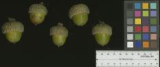 | | 2014 | COLLECTED | 09/19/2014 | Missouri: Mississippi County; Big Oak Tree State Park. | 36.64463600, -89.28721300 | 108 | Native, wet woods. Growing in association with Fraxinus sp., Liquidambar styraciflua, Carya laciniosa, Quercus macrocarpa, and Ulmus sp. | Wild material | Acorns rather green approximately 2-3 weeks away from peak maturity. Specimen sampled approximatley 100' in height. | 1922339 | NA 82038 |
| 5 | NA 81010 | JDC/QB/2008/079/149 | Quercus bicolor Willd. | Iowa, United States | NA |  | | 2008 | COLLECTED | 10/21/2008 | Chichaqua Wildlife Habitat Park bottoms, near Elkhart, NW 1/4 of NW 1/4 of Section 32, T81N, R22W, Loring Quad, Polk County. | 41.79000000, -93.43972222 | 247 | | Wild material | A couple of specimens are approximately 300 years in age. Very large mature specimens, approximately 70-90 feet in height and 4-5 feet d.b.h. Largest specimen sampled was 54.5" d.b.h. A small proportion of seedlings during grow out were noted to be Q. bicolor x Q. macrocarpa hybrids. | 1788225 | NA 81010 |
| 6 | Ames 23752 | NSA 960194 | Quercus hybr. | Nebraska, United States | NC7 |  | | 1997 | COLLECTED | PRE 1997 | Southwest of Salem approximately 2.6 miles, T1N R15E NW 1/4 NW 1/4 Sec. 21, Richardson County. | 40.04268000, -95.74558000 | 330 | Prairie knoll/ridge, very dry and rocky substrate. Growing in association with Rhus sp., Liatris aspera (white and purple), Juniperus virginiana, Quercus rubra, Quercus macrocarpa, and Schizachyrium scoparium. | Wild material | Specimens at the collection site in nature are represented as very large/old plants, approximately 5.0 meters in height with trunk diameters to 25.0 cm. After 15 years of growth in cultivation in central Iowa, specimens average approximately 3.5 x 3.5 meters. This species is reported to sucker, but all specimens of this accession have shown no signs of suckering while grown in cultivation. Peak fall color tends to occur during the second week in October in central Iowa ranging from reddish-orange; brownish-red, brownish-orange, etc. Acorn production tends to be consistently heavy every year and can initiate production after three years in age. Peak fruiting tends to occur between 5-15 of September in central Iowa, which is approximately 1 week prior to Q. muehlenbergii. Acorns are extremely favored by deer, rabbits, raccoons, turkeys and bluejays. Quercus prinoides in Nebraska is extremely rare. To date (2022), only two counties totalling four localities have recorded this taxa including Richardson County: two areas near Salem; one in Indian Caves State Park and one in Nemaha County described as near Nemaha. Species tends to be restricted to dry rocky upland hills and bluffs. Recent research (Hipp et al., 2019), noted that using the unweighted pair group method with arithmetic mean and non-metric multidimensional scaling ordination did not separate individuals of Q. muehlenbergii and Q. prinoides as distinct species. However, W. M. Keith Jr. (1957) states that "Q. muehlenbergii never spreads vegetatively and acorns are rarely borne until it has attained small tree size whereas Q. prinoides bears at extremely small sizes, usually a foot or so high and spreads vegetatively via rhizomes". Therefore, genetics of this accession most likely represents the hybrid of Q. prinoides x Q. muehlenbergii under the assumption that the true Q. prinoides is represented only by those that clonally spread via rhizomes. Further research is needed to clarify the identity of Q. prinoides. This accession is therefore being listed as Q. hybr. Specimens are clearly "dwarf" or shrubby in growth habit and produce acorns at extremely early ages, but do not spread via rhizomes. | 1543547 | Ames 23752 |
| 7 | PI 710493 | CBG-9354 | Lespedeza capitata Michx. | Wisconsin, United States | S9 |  | | 2019 | | | | | | | Wild material | | 2092784 | PI 710493 |
| 8 | PI 667435 | JDC-0192007 | Liatris punctata Hook. | Nebraska, United States | OPGC | | | 2007 | COLLECTED | 09/01/2007 | Approximately 0.5 mile south of the intersection of 561 Avenue and 835 1/2 Road, then 0.25 mile south, Wood Duck Wildlife Management Area, approximately 3 miles southwest of Stanton, Stanton County. | 41.93444444, -97.32361111 | 466 | Prairie knoll. Very dry, sandy soil. Associated with Penstemon grandiflorus, Quercus macrocarpa, and Yucca. | Wild material | | 1740667 | PI 667435 |
| 9 | PI 691664 | BC 1 | Silphium terebinthinaceum Jacq. | Ohio, United States | W6 | | | 2004 | COLLECTED | 09/30/2004 | Bigalow Cemetery State Nature Preserve, Madison County. State route 161 West from Columbus, South on Rosedale Road | 40.10972222, -83.41916667 | | Drainage(1-well, 4-poor): 3 Full sun. Slope: None. Small prairie remnant in pioneer cemetery, total land area approx 100 m . Surrounded by farm fields, road. | Wild material | 5-7', very large cordate leaves at plant base. Yellow rays 2-3 cm. (2n=14) Sample size: 50. Population size: 200. Site size: 10 square meters. | 1690533 | PI 691664 |
| 10 | PI 664832 | L.K. 24 | Echinacea purpurea (L.) Moench | Ohio, United States | NC7 |  | | 2004 | COLLECTED | 11/15/2003 | State Route 161 West from Columbus, south on Rosedale Road, Bigelow Cemetery State Nature Preserve, Madison County. | 40.10972222, -83.41916667 | 301 | Full sun (except for shading from taller prairie plants) on flat ground. Dark, loamy soil with some gravel and a little clay, fair to good drainage. | Wild material | Somewhat clump forming. Toothed/serrated margin, long petioles, pubescent, impressed veins. 3-4 feet in height. Rays reddish purple. Flower heads 3-4 inches in diameter; bristly central disk. | 1655342 | PI 664832 |
| 11 | PI 649714 | 13a | Drymocallis arguta (Pursh) Rydb. | Iowa, United States | NC7 |  | | 2003 | COLLECTED | 09/14/2003 | North Bear Creek Wildlife Area near Highlandville, T100N, R7W N edge of SE 1/4 of SW 1/4 of Sec. 25, Dorchester Quad, Winneshiek County. | 43.44583333, -91.62222222 | 311 | Dolomite cliffs. Half sunny. Edge of sheer cliff with a north to northwest aspect. Rock crevices. | Wild material | | 1649464 | PI 649714 |
| 12 | PI 633671 | SC 4 | Echinacea purpurea (L.) Moench | Ohio, United States | NC7 |  | | 2000 | COLLECTED | 09/30/2004 | | | | Site size 5 square meters; total land area approximately 300 feet x 300 feet. | Wild material | Plants noted in nature measuring 3-4 feet in height. Lanceolate lower leaves. Flower heads 3 inches in diameter, rays reddish purple, drooping. | 1606281 | PI 633671 |
| 13 | PI 613194 | V. arboreum Missouri | Vaccinium arboreum Marshall | Missouri, United States | COR |  | | 1993 | COLLECTED | 10/1992 | T34N R3E, See. 15, NE 1/4 and Sec. 16, NW 1/4. Elephant Rocks State Park, Iron County, Missouri. | 37.65000000, -90.68333000 | 0 | Plants growing in exposed granite rocky area and extending into the understory of the surrounding forest at the base of the rocks. | Wild material | Elephant Rocks are an exposed 1.6-2.0 ha of granite rising 30 m above surrounding landscape. Large population of plants, predominant species in the rocky area and population extended into the understory of the surrounding forest at the base of the rocks. Fruit ripen at this site from late August until a hard freeze. Green fruit have been seen in late October at this site. The fruit was collected in early October 1992. Fruiting plants ranging from 1.2-4.6 m tall. Both shrub and small tree habit; trunks up to 10 cm in diameter. Leaves were glossy and dark green. Fruit ranging from dark blue to black. Fruit size from 0.4-1.0 cm in diameter. Location in crevices suggest drought tolerance; during an extreme drought in 1991, oaks (Quercus alba and Q. macrocarpa) in the area appeared to be dying from drought while the V. arboreum appeared unaffected. No visible winter injury or insect damage. Minimal disease problems; Ophiodothella spp. which doesn't appear to affect the plant and som fruit that appeared to have mummyberry (Monilinia spp.). Seed from this population were germinated and several seedlings submitted to the NCGR. | 1011294 | PI 613194 |
| 14 | PI 495609 | APS/GD/2013/003/088 | Gymnocladus dioicus (L.) K. Koch | Missouri, United States | NC7 |  | | 1984 | COLLECTED | 09/22/1984 | Squaw Creek N.W.R., Section 30, T61N, R38W, Holt County. | 40.06555556, -95.22611111 | 303 | Intermediate elevation and bases of slopes. | Wild material | | 1390545 | PI 495609 |
| 15 | Ames 36697 | APS/JC/2025/XXX/XXX | Juniperus communis L. | Iowa, United States | NC7 |  | | 2025 | COLLECTED | 09/15/2025 | Located off Iowa River Drive approximately 2.5 miles southwest of New Albin, T100N R4W NE 1/4 NW 1/4 Sec. 21. | 43.46830000, -91.32128000 | 207 | Sandy ridge of a power line cut. | Wild material | | 2192820 | Ames 36697 |
| 16 | Ames 36260 | Thomson Causeway Recreation Area | Cornus drummondii C. A. Mey. | Illinois, United States | NC7 |  | | 2024 | COLLECTED | 08/19/2024 | Thomson Causeway Recreation Area, approximately 1 mile southwest of Thomson. Scattered along Potter Road starting just east of the causeway heading west, and along the gravel service road to the south. T23N R3E SE 1/4 Sec. 26. | 41.94919700, -90.11822100 | 179 | Floodplain of wetland complex along east bank of Mississippi River. Soils are moist and seasonally inundated with high organic matter content. | Wild material | Shrubs in nature measuring approximately 10 feet in height (to 15 feet) with varying degrees of red pigmentation on the pedicles. Peak fruit ripening occurred in late August 2024. Minor foliar disease noted at the time of collection. Growing as individual shrubs in shadier locations and forming thickets in sunnier sites. | 2168984 | Ames 36260 |
| 17 | Ames 36251 | JDC/UT/2024/008/1130 | Ulmus thomasii Sarg. | Minnesota, United States | NC7 | 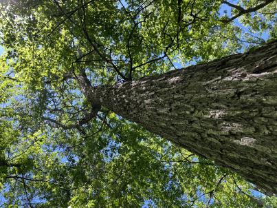 | | 2024 | COLLECTED | 06/05/2024 | Near southeast edge of Kasota Lake approximately 9.0 miles east, southeast of Willmar, T119N R34W SE 1/4 NE 1/4 Sec. 36 and also Robbins Island Park in Wilmar, T119N R35W Sec. 11. | 45.07399600, -94.88484100 | 352 | Deciduous woods | Wild material | Ulmus thomasii (Rock elm) is an underutilized tree species both in conservation and in the urban landscape. Described by Charles Sprague Sargent (first director for the Arnold Arborteum) as "heavy, hard, very strong and tough, closely grained, and susceptible of receiving a beautiful polish". Historically noted for a variety of uses in woodworking including furniture, heavy agricultural implements, timber frame buildings, pianos, hockey sticks, and hand tools. Ulmus thomasii is extremely drought tolerant, adaptable to very calcareous soils, and compared to U. americana or U. rubra has a very conservative growth rate requiring minimal attention in regards to pruning. Rock elm naturally tends to develop into a nice structural specimen in the landscape, unlike other fast growing cultivars in the nursery trade needing frequent attention. Rock elm has very fissured bark and is well known for maintaining a strong central leader resulting in a very attractive, pyramidal form. Despite many literature sources stating that "wings" on the stems are a key identifiying characteristic, this trait is not reliable and many genotypes may completely lack "wings" on the stems. While growth habit and morphology of dormant buds (very pointy) are good traits to help aid in identification, fruits are the best way to confirm identity. Fruits are densly pubescent, often described as "inflated" and generally reach maturity a couple weeks after Ulmus rubra and Ulmus americana. U. thomasii inflorescences are rather distinguishable from other Ulmus in being pendulous. Fruits are extremely prized treats for many birds, where fruits are often "robbed" prior to full maturity. Fruits are also highly prized by many other animals such as mice, squirrels, chipmunks, turkeys, etc. and are generally consumed within hours after fruit abscission. The native range of U. thomasii is concentrated in the northeastern United States and into Canada with disjunct populations documented in northwestern Missouri and northwestern Arkansas (Little, E. L. Jr. 1971). In the 1895 Silva of North America (vol. 7) it was stated that, “The value of the wood of the Rock Elm threatens its extinction and most of the large trees have already been cut.” Today, while rock elm is rather rare, especially in areas near the edges of its range, many states list the species as endangered or threatened warranting preservation efforts. Genetics of this accession would be representative of the species northwestern edge of its native range. Majority of specimens noted did not have characteristic "wings" on the stems and measured approximately 20" DBH or more with a few specimens nearing 30". Heights estimated between 70-90'. Rock elm in this area could be classified as locally abundant. | 2167953 | Ames 36251 |
| 18 | WLP 3492 | St. Francois State Park | Hydrangea arborescens L. | Missouri, United States | NA |  | | 2024 | COLLECTED | 01/19/2024 | St. Francois State Park, 8920 US Highway 67 North, approximately 3.2 miles north-northeast of Bonne Terre. | 37.96381000, -90.53403000 | 202 | Rocky outcrops above Big River and rocky areas on bank of Big River. | Wild material | | 2166135 | WLP 3492 |
| 19 | OPGC 8815 | CBG- 10787 | Maianthemum racemosum (L.) Link subsp. racemosum | Wisconsin, United States | OPGC | | | 2023 | | | | | | | Wild material | | 2142251 | OPGC 8815 |
| 20 | W6 61347 | CBG- 10759 | Brachyelytrum erectum (Schreb.) P. Beauv. | Wisconsin, United States | W6 |  | | 2023 | | | | | | | Wild material | | 2142229 | W6 61347 |
| 21 | W6 61417 | CBG- 10852 | Verbesina alternifolia (L.) Britton ex Kearney | Illinois, United States | W6 |  | | 2023 | | | | | | | Wild material | | 2142299 | W6 61417 |
| 22 | W6 61418 | CBG- 10853 | Agastache scrophulariifolia (Willd.) Kuntze | Illinois, United States | W6 |  | | 2023 | | | | | | | Wild material | | 2142300 | W6 61418 |
| 23 | Ames 36017 | AS/GD/2023/002/212 | Gymnocladus dioicus (L.) K. Koch | Wisconsin, United States | NC7 |  | | 2023 | | | | | | | Wild material | Kentucky coffeetree in Wisconsin is rather rare. The Wisconsin Natural Heritage Inventory Program currently (2023) lists this taxon in Wisconsin as a species of concern with a state rank of S2 (Imperiled in Wisconsin due to a restricted range, few populations or occurrences, steep declines, severe threats, or other factors.) This accession represents genetics from a localized population with a near equal porportion of male and female specimens. While there are other known locations along the Wisconsin River, this population is producing seeds. The other known locations represent single clones that are distant enough from other existing clones that prevent the transfer of pollen and thus lack the ability to produce seed or will rarely produce. | 2141550 | Ames 36017 |
| 24 | NA 89039 | RJL2022IL-001 | Ptelea trifoliata L. | Illinois, United States | NA | | | 2022 | COLLECTED | 09/28/2022 | Site of plant habitat is located at 823 E Co Rd 1220, Hamilton, IL 62341 which is the property where Jacob's Geode Shop and Mine is located. This species is scattered and relatively common throughout the woodlands on this site. | 40.37848400, -91.35390200 | 175 | Plants growing in shade to part-shade of deciduous woodlands above a small creek.
Soils: The underlying geology of this area is of Mississippian origin and comprised of Warsaw Formation and Salem Limestone. Major lithological components include limestone that can be shaly, oolitic, bioclastic, or cherty. Minor lithological components include siltstone that can contain geodes or drusy quartz and can be calcareous.
Source: USGS Illinois Geologic Map Data (https://mrdata.usgs.gov/geology/state/sgmc-unit.php?unit=ILMws%3B0)
The surface soil profile of this area is Coffeen silt loam, 0 to 2 percent slopes, that are frequently flooded. The Coffeen series consists of very deep, somewhat poorly drained, moderately permeable soils on flood plains, low terraces or benches, toe slopes, and alluvial fans. They formed in silty alluvium. Much of the alluvium is of local origin derived from the nearby loess-covered uplands.
Source: NRCS Web Soil Survey (https://websoilsurvey.sc.egov.usda.gov/App/WebSoilSurvey.aspx) | Wild material | | 2139604 | NA 89039 |
| 25 | Ames 35887 | JDC/MR/2022/034/1014 | Morus rubra L. | Iowa, United States | NC7 |  | | 2022 | COLLECTED | 07/12/2022 | Waubonsie State Park located north, northwest of Hamburg, T68N R42W Sec. 29 and Sec. 32. | 40.67552500, -95.68690400 | 355 | Mid slope (ranging from 10-30 degrees) to base of slopes and along all drainages and valleys of deciduous woods. | Wild material | The native range for Red Mulberry is reported from the eastern margin of the Great Plains, extending north to southern Ontario, Canada, and distributed as far south as southern Florida (Little, 1971). Conservation assessments in North America indicate current (2026) and future concern for the species including Michigan (threatened); Massachusetts (endangered); Ontario Canada (endangered); with NatureServe's 2025 global G5 rank due to genetic swamping and habitat pressure. Red Mulberry seems to be extremely localized to moist, floodplain areas that are high-quality bottomland forests. This accession represents genetics collected from the northwestern edge of the species native range. Specimens sampled in nature displayed the following morphological characters: acuminate leaf tips, impressed veins, pubescent upper and lower leaves, flaky bark (often with tiny pin holes (insect emergence holes)), cordate leaf base, and umbrella-shaped growth habit. M. rubra specimens noted ranged in size from 1"-23" inches DBH with some of the tallest specimens reaching 70' in height. The largest specimen sampled (#172-13) measuring 23.25" DBH. Estimated hundreds, perhaps a thousand specimens of M. rubra noted within the park with very little representation of hybrids or Morus alba. Representation of M. rubra outside of park boundaries is near completely absent and the presence of hybrids and M. alba is extremely evident. Soluble solids content from fruits collected in the wild ranged from 19.0-32.9 degrees Brix. This range of Brix values is likely a result of genetic diversity and also variation in maturity of fruits. Fruits selected for Brix measurements were black in color. The specimen sampled with the highest Brix value was #172-9. All M. rubra specimens noted at time of sampling (12 July 2022) were exhibiting determinate growth compared to local hybrids and M. alba, which were still actively growing with newly emerging leaves. The first study (Adhikari et al. 2026) on the mitogenome of M. rubra utilized sample #172-13 (Ames 35887 Tree #13) reporting 359,221 base pairs (bp) long with 45.8% GC content, comprising 57 genes: 32 protein-coding, 21 transfer, and four ribosomal RNAs. | 2138220 | Ames 35887 |
| 26 | Ames 35884 | AS/MR/2022/003/133 | Morus rubra L. | Iowa, United States | NC7 |  | | 2022 | COLLECTED | 07/06/2022 | Chichaqua Bottoms Greenbelt located northeast of Bondurant, T81N R22W Sec. 33 and also T80N R22W Sec. 10. | 41.78917100, -93.41777300 | 247 | Floodplain. | Wild material | Specimens sampled in nature displayed the following morphological characters: elongated acuminate leaf tips, impressed veins, pubescent upper and lower leaves, flaky bark (often with tiny pin holes (insect emergence holes)), cordate leaf base, and umbrella-shaped growth habit. Majority of specimens were approximately 30-50' in height with the largest diameter specimen (133-6) measuring 19.5" DBH. All M. rubra specimens noted were exhibiting determinate growth compared to local hybrids and M. alba, which were still actively growing with newly emerging leaves. Soluble solids content for fruit samples collected in nature ranged from 12.8-22.8 degrees Brix. This range of Brix values is likely a result of genetic diversity and also variation in maturity of fruits. The highest Brix value was from specimen 133-4. | 2138217 | Ames 35884 |
| 27 | W6 59934 | CBG-10657 | Calamagrostis canadensis (Michx.) P. Beauv. | Illinois, United States | W6 | | | 2021 | | | | | | | Wild material | | 2132513 | W6 59934 |
| 28 | W6 59961 | CBG-10690 | Dasiphora fruticosa (L.) Rydb. | Illinois, United States | W6 | | | 2021 | | | | | | | Wild material | | 2132539 | W6 59961 |
| 29 | OPGC 7576 | McFarland Park | Solidago flexicaulis L. | Iowa, United States | OPGC |  | | 2021 | COLLECTED | 09/26/2021 | McFarland Park just north, northeast of Ames, T84N R23W Sec. 7 | 42.09667500, -93.57083500 | 288 | Moist areas near streambanks and bottomlands in hardwood forest understory. | Wild material | Plants in nature ranged in height from approximately one to three feet, growing as spreading clumps. Peak flowering in 2021 occurred near 18 September. | 2132830 | OPGC 7576 |
| 30 | Ames 35746 | Guye Woods | Acer saccharum Marshall subsp. nigrum (F. Michx.) Desmarais | Iowa, United States | NC7 |  | | 2021 | COLLECTED | 09/08/2021 | Guye Woods County Park located 6.0 miles northeast of Winterset, T76N R27W NE1/4 Sec. 4 | 41.41235000, -93.96373000 | 278 | Moist deciduous maple, oak, hickory forest, northwest facing slope above the North River. | Wild material | Multiple specimens in this population were observed to be 24" diameter at breast height (DBH) or larger with the largest specimen encountered at the time of collection measuring 36.5" DBH.
Morphological traits of leaves suggests sampled specimens are true to type of Acer saccharum subsp. nigrum including leaves with three distinct points, leathery/thick, and drooping in appearance. On September 25, 2020 (Schmitz, A., personal communication, 31 January 2022), peak fall color on Acer saccharum subsp. nigrum at Guye Woods was observed with specimens having a clean yellow fall color, also indicative of Acer saccharum subsp. nigrum.
| 2122010 | Ames 35746 |
| 31 | OPGC 8359 | CBG-10615 | Symphyotrichum drummondii (Lindl.) G. L. Nesom | Illinois, United States | OPGC | | | 2021 | | | | | | | Wild material | Plant numbers sampled estimated. | 2120231 | OPGC 8359 |
| 32 | W6 59234 | CBG-10548 | Dasistoma macrophyllum (Nutt.) Raf. | Illinois, United States | W6 | | | 2021 | | | | | | | Wild material | Received as Dasistoma macrophylla. Plant numbers estimated. Few this year; abundant other years in numerous locations. | 2120206 | W6 59234 |
| 33 | W6 59274 | CBG-10598 | Scrophularia marilandica L. | Illinois, United States | W6 | | | 2021 | | | | | | | Wild material | Plant numbers sampled estimated. | 2120183 | W6 59274 |
| 34 | Ames 35612 | Ames 35612 | Agastache nepetoides (L.) Kuntze | Iowa, United States | NC7 |  | | 2020 | COLLECTED | 10/15/2020 | Private property located approximately 5.8 miles southeast of Westfield on both sides of N Ridge Road, T91N R48W SW 1/4 Sec. 16, Sioux Twp., Plymouth County | 42.69938500, -96.51933700 | 419 | Savanna (bur oak, walnut, hackberry). Loess hills and valleys. Distrurbed open forest. | Wild material | Plants sampled in nature measuring approximately 3-4 feet in height. | 2110274 | Ames 35612 |
| 35 | Ames 35550 | Scuppernong Prairie | Salix myricoides Muhl. | Wisconsin, United States | NC7 |  | | 2020 | COLLECTED | 09/04/2020 | Two areas of Salix myricoides were identified approximately 2.5 miles apart. The northern area is located along the Scuppernong Springs Nature Trail (intersection of State Highway 67 and County Highway ZZ) and the adjacent marsh prairie to the south. The southern area is located in the Scuppernong Prairie State Natural Area, at the intersection of Wilton Road and County Highway N. Kettle Moraine State Forest - Southern Unit, Waukesha County | 42.93363600, -88.47242400 | 260 | Marsh, riverbank, prairie and woodland. | Wild material | Bayberry willow is native to areas of the northeastern U.S. and north into Canada, localized around the Great Lakes region. Known to occur on shorelines/dunes but also in swamps, fens, and on talus (Haines 2004) with the potential to reach six meters in height (Dorn 1995). Ornamental characteristics include glaucous lower leaf blades that appear chalky white. Staminate flowering occurs before or during leaf expansion with purple-turning-yellow anthers (Haines 2004). This accession was sampled on wet, slightly above neutral pH soils (6.0-7.3) which may result in superior performance in the urban landscape. Under cultivation, the plants grow in a widely spreading growth habit (some are nearly prostrate); however, this trait was not noticed at the time of collection from nature. Shrubs noted in nature measuring 0.5 to 2 m tall. The two areas sampled contained both Salix myricoides and Salix discolor, and likely hybrids between the two species. Attempts were made to collect only Salix myricoides based on the following characteristics: white undersides of the leaves, large stipules and finely serrated leaf margins. During collection on 6 April 2021, S. discolor was in flower while S. myricoides was not yet flowering. | 2107011 | Ames 35550 |
| 36 | Ames 35235 | JDC/AF/2019/017/896 | Agastache foeniculum (Pursh) Kuntze | Wisconsin, United States | NC7 |  | | 2019 | COLLECTED | 09/25/2019 | Brule River watershed located along E. Jersett Road appproximately 4.92 miles northeast of Solon Springs,T45N R11W: NE ¼ NW ¼ Sec. 13; NW ¼ NW ¼ Sec. 14; and NW ¼ Sec. 15. | 46.38906900, -91.68919500 | 357 | Roadside, sandy soils | Wild material | Plants measuring approximately 3-4' in height with attractive pale lavender to lilac colored flowers. Spikes measuring circa 5" in length. Leaves with undersides whitish in color. Peak flowering occurred 5 August 2019 in nature. Species rather rare in immediate area and county. | 2097771 | Ames 35235 |
| 37 | Ames 35221 | JDC/AF/2019/019/898 | Agastache foeniculum (Pursh) Kuntze | Wisconsin, United States | NC7 |  | | 2019 | COLLECTED | 09/17/2019 | Crex Meadows Wildlife Management Area located along N. Refuge Road approximately 7.0 miles north of Grantsburg (sampled within T39N R19W SW 1/4 Sec. 12; T39N R18W NE1/4 Sec. 8; T39N R18W NW1/4 Sec. 9; and T39N R18W SE1/4 Sec. 5), Burnett County | 45.88440500, -92.61196900 | 290 | Prairie remnant with sandy soils | Wild material | Plants measuring approximately 3-4' in height with attractive blue flowers circa 5-6" spikes and leaves with undersides whitish in color. Peak flowering occurred 5 August 2019 in nature. Species locally abundant in area. | 2097757 | Ames 35221 |
| 38 | Ames 35222 | JDC/MF/2019/032/911 | Monarda fistulosa L. | Wisconsin, United States | NC7 |  | | 2019 | COLLECTED | 09/17/2019 | Crex Meadows Wildlife Management Area located along N. Refuge Road approximately 7.0 miles north of Grantsburg (sampled within T39N R19W SW 1/4 Sec. 12; T39N R18W NE1/4 Sec. 8; T39N R18W NW1/4 Sec. 9; and T39N R18W SE1/4 Sec. 5), Burnett County | 45.88440500, -92.61196900 | 290 | Prairie remnant with sandy soils. | Wild material | Plants measuring approximately 2-3' in height with attractive pink flowers. Peak flowering occurred circa 28 July 2019 in nature. Species locally abundant to infrequent in area. | 2097758 | Ames 35222 |
| 39 | OPGC 7496 | CBG-9546 | Solidago ulmifolia Muhl. ex Willd. | Illinois, United States | OPGC |  | | 2019 | | | | | | | Wild material | | 2092814 | OPGC 7496 |
| 40 | Ames 34208 | NAO/UT/2018/23/48 | Ulmus thomasii Sarg. | Illinois, United States | NC7 |  | | 2018 | COLLECTED | 05/31/2018 | Private property located 2.0 miles northeast of Plano along Big Rock Creek just off Needham Road, T37N R6E SW 1/4 NE 1/4 Sec. 14 | 41.68543300, -88.51368600 | 188 | Flat open (mowed) areas and edge of woods. | Wild material | Ulmus thomasii (Rock elm) is an underutilized tree species both in conservation and in the urban landscape. Charles Sprague Sargent (first director of the Arnold Arboretum of Harvard University, Boston, MA) described the wood of Rock Elm as "heavy, hard, very strong and tough, closely grained, and susceptible of receiving a beautiful polish". Historically noted for a variety of uses in woodworking including furniture, heavy agricultural implements, timber frame buildings, pianos, hockey sticks, and hand tools. U. thomasii is extremely drought tolerant, adaptable to very calcareous soils, and compared to U. americana or U. rubra has a very conservative growth rate requiring minimal attention in regards to pruning. Rock elm naturally tends to develop into a nice structural specimen in the landscape, unlike other fast growing U. americana cultivars in the nursery trade needing frequent attention. Rock elm has very fissured bark and is well known for maintaining a strong central leader resulting in a very attractive, pyramidal form. Despite many literature sources stating that "wings" on the stems are a key identifiying characteristic, this trait is not reliable and many genotypes may completely lack "wings" on the stems. While growth habit and morphology of dormant buds (very pointy) are good traits to help aid in identification, fruits are the best way to confirm identity. Fruits are densly pubescent, often described as "inflated" and generally reach maturity a couple weeks after U. rubra and U. americana. U. thomasii inflorescences are rather distinguishable from other Ulmus in being pendulous. Fruits are extremely prized treats for many birds, where fruits are often "robbed" prior to full maturity. Fruits are also highly prized by many other animals such as mice, squirrels, chipmunks, turkeys, etc. and are generally consumed within hours after fruit abscission. The native range of U. thomasii is concentrated in the northeastern United States and into Canada with disjunct populations documented in northwestern Missouri and northwestern Arkansas (Little, E. L. Jr. 1971). In the 1895 Silva of North America (vol. 7) it was stated that, “The value of the wood of the Rock Elm threatens its extinction and most of the large trees have already been cut.” Today, since rock elm is rather rare, especially in areas near the edges of its range, many states list the species as endangered or threatened warranting preservation efforts. Genetics of this accession were collected on private property in north central Illinois (Kendall County) from a localized population in nature represented by 10-16" DBH specimens with little to no signs of decline. | 1963391 | Ames 34208 |
| 41 | Ames 34201 | NAO/UR/2018/22/47 | Ulmus rubra Muhl. | Iowa, United States | NC7 |  | | 2018 | COLLECTED | 05/24/2018 | Private property located 5.0 miles west of Grinnell off N 39th Ave E., T80N R17W NW ¼ SW ¼ Sec. 15, Jasper County | 41.73626700, -92.82183600 | 325 | Dry ridge top. Old-growth remnant woods historically and currently utilized as cattle pasture. | Wild material | Mature 20-26" d.b.h. (inches) specimens with little to no signs of decline. | 1963308 | Ames 34201 |
| 42 | Ames 34086 | APS/HD/2017/038/297 | Helianthus divaricatus L. | Illinois, United States | NC7 |  | | 2017 | COLLECTED | 11/11/2017 | Trail of Tears State Forest approximately 6.11 miles northwest of Anna along North Forest Road (both sides), T12S R2W NW 1/4 NW 1/4 Sec. 4, Union County | 37.50864000, -89.33891000 | 218 | Ridgetop of dry-mesic oak forest | Wild material | Plants 2-5 feet tall, elongated leaves quite rough on both the upper and lower sides. Herbarium specimen is clearly Helianthus divaricatus, however, there is a large amount of variation in seed size, shape, and color. Seed sample may contain genetics of Helianthus hirsutus. | 1954437 | Ames 34086 |
| 43 | Ames 34052 | PB1701 | Betula papyrifera Marshall | Minnesota, United States | NC7 |  | | 2017 | COLLECTED | 09/16/2017 | Detroit Mountain area just east of Detroit Lakes approximately 2.9 miles, T139N R40W SW 1/4 NE 1/4 and NE 1/4 NE 1/4 NW 1/4 Sec. 21, Becker County | 46.81210900, -95.78208300 | 457 | Mixed deciduous woods. | Wild material | | 1954341 | Ames 34052 |
| 44 | Ames 34007 | JDC/PP/2017/052/806 | Pinus ponderosa P. Lawson & C. Lawson | Nebraska, United States | NC7 |  | | 2017 | COLLECTED | 08/29/2017 | Areas on both north and south sides of the Niobrara River between Long Pine and Springview, T32N R21W; T32N R20W; and T31N R21W in Brown and Keya Paha Counties. | 42.75716800, -99.74657300 | 685 | Dry, rocky ridgetops. | Wild material | Genetics represent the extreme eastern edgeo of the species native range. | 1953921 | Ames 34007 |
| 45 | WLP 2602 | JDC/TA/2017/053/807 | Tilia americana L. | Nebraska, United States | NA |  | | 2017 | COLLECTED | 08/29/2017 | Niobrara River Valley just 25.9 miles east, southeast of Valentine, T33N R23W Sec. 32 and Sec. 33. | 42.78284200, -100.05716700 | 658 | Floodplain and also base of adjacent bluffs/slopes (north-facing). | Wild material | Genetics represent the extreme western edge of the species native range. | 1953922 | WLP 2602 |
| 46 | Ames 33918 | APS/GD/2017/008/267 | Gymnocladus dioicus (L.) K. Koch | Minnesota, United States | NC7 |  | | 2017 | COLLECTED | 03/16/2017 | Minnesota River watershed covering approximately 9.0 river miles between Redwood Falls and Vicksburg Park, Renville County | 44.61447700, -95.14878600 | 254 | Mixed habitats, both upland dry sites, wet sites, and rocky sites. | Wild material | | 1946985 | Ames 33918 |
| 47 | Ames 33919 | JDC/AX/2017/009/763 | Agastache nepetoides (L.) Kuntze | Minnesota, United States | NC7 |  | | 2017 | COLLECTED | 03/17/2017 | Minnesota River watershed approximately 6.0 miles north, northwest of Redwood Falls, T113N R36W NW 1/4 SW 1/4 SW 1/4 Sec. 2, Renville County | 44.61767000, -95.15602000 | 303 | Shallow soils. Growing on rocky outcropping. Growing in association with Gymnocladus dioicus, Quercus macrocarpa, and Celtis occidentalis | Wild material | Specimens sampled in nature measuring approximately 4' in height. Floral spikelet dense, 6-8" in length, greenish-white flowers. Stems stout, stongly four-angled and smooth. Seeds with minute hairs that are more pronounced on distal end (opposite of hilum). | 1946986 | Ames 33919 |
| 48 | Ames 33921 | APS/GD/2016/001/236 | Gymnocladus dioicus (L.) K. Koch | Minnesota, United States | NC7 |  | | 2017 | COLLECTED | 03/17/2017 | Blue Earth River watershed covering approximately 9.0 river miles from Vernon Center south to the county line, Blue Earth and Faribault Counties | 43.87215300, -94.17375800 | 316 | Mixed habitats, both upland dry and wet sites. | Wild material | | 1946988 | Ames 33921 |
| 49 | Ames 33922 | JDC/PO/2017/012/766 | Platanus occidentalis L. | Iowa, United States | NC7 |  | | 2017 | COLLECTED | 03/20/2017 | Skunk River watershed of Chichaqua Bottoms Greenbelt approximately 5.75 miles east, southeast of Elkhart, Polk County | 41.77733500, -93.40833400 | 243 | Floodplain. | Wild material | | 1946989 | Ames 33922 |
| 50 | W6 51581 | CBG-4157 | Heracleum sphondylium L. subsp. montanum (Schleich. ex Gaudin) Briq. | Illinois, United States | W6 | | | 2016 | | | | | | | Wild material | | 1942711 | W6 51581 |
| 51 | Ames 33735 | PB16014001 | Betula papyrifera Marshall | North Dakota, United States | NC7 |  | | 2016 | COLLECTED | 08/18/2016 | Bottineau County, North Dakota: Turtle Mountains located approximately 11 miles north, northeast of Bottineau. T163N R74W N1/2 Sec. 16 and T163N R75W NW 1/4 NW 1/4 and also NW 1/4 NE 1/4 Sec. 5. | 48.96006100, -100.31819400 | 700 | Mixed upland forest and wetlands. Growing in association with Quercus macrocarpa, Populus balsamifera, Populus tremuloides, Fraxinus pennsylvanica, Amelanchier sp., Symphoricarpos albus, Corylus sp., Prunus virginiana, Rubus sp., Viburnum opulus var. americanum, and Cirsium arvense. | Wild material | | 1942686 | Ames 33735 |
| 52 | Ames 33288 | APS/GD/2016/009/244 | Gymnocladus dioicus (L.) K. Koch | Michigan, United States | NC7 |  | | 2016 | COLLECTED | 04/05/2016 | Ottawa County: T7N R13W SW 1/4 SW 1/4 NE 1/4 Sec. 32; T7N R13W NE 1/4 NE 1/4 SW 1/4 Sec. 29; and T7N R14W NW 1/4 NW 1/4 Sec. 10 along Grand River both north (approximately 2.87 miles) and east (approximately 3.84 miles) of Allendale. | 43.00148000, -85.91236400 | 184 | Floodplain. | Wild material | | 1940345 | Ames 33288 |
| 53 | Ames 33289 | APS/GD/2016/010/245 | Gymnocladus dioicus (L.) K. Koch | Michigan, United States | NC7 |  | | 2016 | COLLECTED | 04/05/2016 | Ionia County: T5N R5W SW 1/4 SW 1/4 SE 1/4 Sec. 21; T5N R5W NE 1/4 NW 1/4 NW 1/4 Sec. 20; and T5N R5W SW 1/4 SW 1/4 SE 1/4 Sec. 20 along Grand River approximately 4.80 miles south and slightly west of Portland. | 42.80296200, -84.91275400 | 231 | Floodplain. | Wild material | | 1940346 | Ames 33289 |
| 54 | Ames 33291 | APS/GD/2016/015/250 | Gymnocladus dioicus (L.) K. Koch | Michigan, United States | NC7 |  | | 2016 | COLLECTED | 04/07/2016 | Shiawassee County: T6N R4E SE 1/4 SE 1/4 SW 1/4 Sec. 30; T5N R4E SE 1/4 NW 1/4 Sec. 7; and T6N R3E SE 1/4 SE 1/4 NE 1/4 Sec. 25 along Shiawassee River both northeast (approximately 1.35 miles) and southeast (approximately 2.63 miles) of Bancroft. | 42.87985700, -84.03461800 | 244 | Floodplain. | Wild material | | 1940348 | Ames 33291 |
| 55 | WLP 865 | NA 83111 | Carpinus orientalis Mill. subsp. macrocarpa (Willk.) Browicz | Armenia | NA | | | 2016 | COLLECTED | 07/15/2015 | Between the town of Idjevan and Itsakar village. | 40.86416000, 45.17875000 | 1260 | Edge of oak-hornbeam forest. | | | 1951519 | WLP 865 |
| 56 | Ames 32965 | JDC/BA/2015/051/708 | Betula alleghaniensis Britton | Iowa, United States | NC7 | | | 2015 | COLLECTED | 09/15/2015 | Yellow River State Forest, T97N R4W northern edge of SW 1/4 NW 1/4 Sec. 36 | 43.17782100, -91.26584600 | 227 | North-facing algific talus slope (45-60 degrees) adjacent to Paint Creek. Moist deciduous woods. Growing in association with Fraxinus nigra, Staphylea trifolia, Carpinus caroliniana, Quercus rubra, Acer saccharum, Cornus alternifolia, Amelanchier arborea, Ostrya virginiana, Viburnum opulus var. americanum, Cornus rugosa, Cornus alternifolia, Zanthoxylum americanum, Viburnum rafinesqueanum, Cypripedium pubescens, Ribes sp.,Corylus sp., Juniperus virginiana, Dirca palustris, Ulmus thomasii, Prunella vulgaris, Diervilla lonicera, Quercus macrocarpa, Carya cordiformis, Taxus canadensis, Tilia americana, Adiantum pedatum, and Aconitum noveboracense. | Wild material | | 1927435 | Ames 32965 |
| 57 | Ames 32966 | JDC/VA/2015/052/709 | Viburnum opulus L. var. americanum Aiton | Iowa, United States | NC7 |  | | 2015 | COLLECTED | 09/15/2015 | Yellow River State Forest, T97N R4W northern edge of SW ¼ NW ¼ Sec. 36. | 43.17778200, -91.26642800 | 239 | North-facing algific talus slope (45-60 degrees) adjacent to Paint Creek. Moist deciduous woods. | Wild material | Formerly known as Viburnum trilobum, American highbush cranberry (V. opulus var. americanum) is a North American native shrub that is utilized as an important ornamental and conservation plant that is also harvested as a minor fruit crop (jams/jellies). In nature, this variety is generally found in moist habitats typically along stream banks and swamps where ample moisture is readily available. The native range of V. opulus var. americana is concentrated in the northeastern United States and into Canada (Little, E. L. Jr. 1977). Attractive ornamental characteristics includes showy lacecap flowers in spring and bright red fruits and foliage in the fall. Fruits are tart with a hint of sweetness. The European highbush cranberry (V. opulus var. opulus) is nearly identical to American highbush cranberry other than small glands (<1 mm) on the petiole making the exact determination very challenging resulting in common misidentifications. A major difference between the American and European highbush cranberries is that the European variety produces unpalatable fruit. Recent research has shown that American and European highbush cranberries are genetically distinct and that plants of hybrid origin are uncommon (Tork et al. 2025). Vigorous early spring growth and good tolerance to late spring frosts. Genetic analysis from Tork et al. 2025 confirmed that genetics of this accession represents American highbush Cranberry (Viburnum opulus var. americanum). This accession represents genetics from northeast Iowa and thus the extreme western edge of the species native range. | 1927436 | Ames 32966 |
| 58 | WLP 1096 | JDC/CO/2015/025/681 | Cotinus obovatus Raf. | Missouri, United States | NA |  | | 2015 | COLLECTED | 05/19/2015 | T24N R16W NW 1/4 Sec. 4, SW 1/4 SW 1/4 Sec. 17, and SW 1/4 Sec. 9 Ozark County. Mark Twain National Forest Caney Picnic Area (County Road 935) | 36.79873000, -92.71575700 | 407 | Rocky, very shallow soils. Growing in association with Quercus muehlenbergii, Diospyros virginiana, Cercis canadensis, Viburnum rufidulum, Delphinium carolinianum, Penstemon cobea, Rudbeckia sp., Fraxinus americana, Fraxinus quadrangulata (few), Cornus florida, Oenothera macrocarpa, Juniperus virginiana, Tradescantia sp., and Silphium terebinthinaceum. | Wild material | | 1926254 | WLP 1096 |
| 59 | Ames 32895 | APS/GD/2015/018/200 | Gymnocladus dioicus (L.) K. Koch | Oklahoma, United States | NC7 |  | | 2015 | COLLECTED | 03/15/2015 | Canadian County: Near/adjacent to unnamed creek that empties into the Canadian River, T12N R10W SW 1/4 Sec. 20. Private property approximately 4 miles northeast of Hinton. | 35.49409300, -98.28655400 | 434 | Bottomland. | Wild material | | 1925361 | Ames 32895 |
| 60 | Ames 32899 | APS/GD/2015/026/208 | Gymnocladus dioicus (L.) K. Koch | Oklahoma, United States | NC7 |  | | 2015 | COLLECTED | 03/17/2015 | Roger Mills County: Cottonwood Creek and Dugout Creek watersheds, T17N R25W NE 1/4 SE 1/4 Sec. 34. Antelope Hills area approximately 7 miles northeast of Durham. | 35.90486100, -99.84879100 | 664 | Lower elevations. | Wild material | | 1925365 | Ames 32899 |
| 61 | Ames 32904 | APS/GD/2015/032/214 | Gymnocladus dioicus (L.) K. Koch | Oklahoma, United States | NC7 |  | | 2015 | COLLECTED | 03/19/2015 | Osage County: Sand Creek watershed area, T27N R8E SE 1/4 NW 1/4 Sec. 10. Tallgrass Prairie Preserve approximately 13 miles northwest of Pawhuska. | 36.83425300, -96.43091600 | 307 | Dry, rocky outcroppings and floodplain. | Wild material | | 1925370 | Ames 32904 |
| 62 | Ames 32831 | RLD1401 | Cornus rugosa Lam. | Minnesota, United States | NC7 | | | 2014 | COLLECTED | 09/03/2014 | Becker County near Pine Island Lake. | 47.14710000, -95.43608330 | 503 | Upland roadside near steep dropoff with lake below. Mixed deciduous and conifer forest. Growing in association with Fraxinus pennsylvanica, Quercus macrocarpa, Populus tremuloides, Betula papyrifera, Picea glauca, Pinus strobus, Sambucus sp., Acer spicatum, Rosa sp., Rubus sp., and Sanicula marilandica. | Wild material | | 1921824 | Ames 32831 |
| 63 | Ames 32835 | GA14014001 | Fraxinus pennsylvanica Marshall | North Dakota, United States | NC7 |  | | 2014 | COLLECTED | 10/30/2014 | Bottineau County, Turtle Mountains. | 48.97000000, -100.45000000 | 737 | Mixed oak-aspen forest | Wild material | | 1921828 | Ames 32835 |
| 64 | WLP 1746 | Ames 32838 | Viburnum opulus L. var. americanum Aiton | North Dakota, United States | NA | | | 2014 | COLLECTED | 10/31/2014 | Turtle Mountains - Bottineau County. | 48.95000000, -100.43000000 | 692 | Wet, aspen forest. Growing in association with Sanicula marilandica, Fragaria virginiana, Trifolium repens, Rubus sp., Typha latifolia, Prunus pensylvanica, Prunus virginiana, Corylus sp., Crataegus sp., Viburnum lentago, Rosa sp., Cornus sericea, Amelanchier sp., Symphoricarpos sp., Salix sp., Betula papyrifera, Populus tremuloides, Ulmus americana, Acer negundo, Quercus macrocarpa, and Fraxinus pennsylvanica. | Wild material | | 1921831 | WLP 1746 |
| 65 | WLP 1967 | HBC1401 | Viburnum opulus L. var. americanum Aiton | North Dakota, United States | NA | | | 2014 | COLLECTED | 09/29/2014 | Jay Wessels Wildlife Management Area located in Pembina County. | 48.80000000, -97.83000000 | 312 | Diverse habitats including edge of swamp and also upland sandy soils. Growing in association Fraxinus pennsylvanica, Fraxinus nigra, Quercus macrocarpa, Acer negundo, Ulmus americana, Populus tremuloides, Populus balsamifera, Toxicodendron radicans, Cornus sericea, Rosa sp., Corylus sp., Prunus virginiana, Ribes sp., Equisetum sp., Rubus sp., IMpatiens capensis, Thalictrum dasycarpum, Fragaria virginiana, Asarum canadense, Calamagrostis canadensis, Sium suave, Solidago gigantea, Poa pratensis, and Bromus inermis. | Wild material | | 1921830 | WLP 1967 |
| 66 | Ames 32222 | APS/GD/2013/014/099 | Gymnocladus dioicus (L.) K. Koch | Illinois, United States | NC7 | | | 2014 | COLLECTED | 03/20/2014 | Timber Creek watershed, Section 19, T22N, R1E, and Section 24, T22N, R1W, just northeast of McLean, McLean County. | 40.34355000, -89.14919700 | 214 | Floodplain. | Wild material | | 1917826 | Ames 32222 |
| 67 | Ames 32229 | APS/GD/2014/014/145 | Gymnocladus dioicus (L.) K. Koch | Indiana, United States | NC7 | | | 2014 | COLLECTED | 03/23/2014 | Tippecanoe River watershed, Section 19, T31N, R1W, just north of Winamac, Pulaski County. | 41.12152000, -86.57319400 | 216 | Floodplain. | Wild material | | 1917833 | Ames 32229 |
| 68 | Ames 32197 | GA13009001 | Fraxinus pennsylvanica Marshall | Minnesota, United States | NC7 |  | | 2014 | COLLECTED | 09/23/2013 | Clearwater County. | 47.18397220, -95.47407220 | | Mixed upland deciduous forest. | Wild material | | 1917223 | Ames 32197 |
| 69 | Ames 32096 | BA13009001 | Fraxinus nigra Marshall | Minnesota, United States | NC7 |  | | 2013 | COLLECTED | 09/23/2013 | T144N R38W, Clearwater County. | 47.25711000, -95.49000667 | 543 | Edges of lakes and forest edges. Growing in association with Fraxinus pennsylvanica, Quercus macrocarpa, Ulmus americana, Populus tremuloides, Populus balsamifera, Acer saccharum, Betula papyrifera, Salix sp., Larix laricina, Quercus rubra, Abies balsamea, Picea glauca, Sambucus canadensis, Cornus rugosa, Acer spicatum, Rosa sp., Viburnum opulus var. americanum, Viburnum dentatum, Alnus sp., Cornus canadensis, Corylus sp., Prunus virginiana, Ribes sp., Prunus pensylvanica, Rhamnus alnifolia, Equisetum sp., Carex sp., Rubus sp., Impatiens capensis, Bromus sp., and Thalictrum dasycarpum. | Wild material | D.B.H. ranged between 3 and 6 inches. | 1914713 | Ames 32096 |
| 70 | Ames 32092 | Ames 32092 | Viburnum rufidulum Raf. | Missouri, United States | NC7 | | | 2013 | COLLECTED | 10/13/2013 | Private property, north of 27640 EE Highway, NE 1/4 of SE 1/4 of Section 4, T47N R15W, Prairie Home, Prairie Home Quad, Cooper County. | 38.85910000, -92.56030000 | 236 | Wooded hillside. North-facing slope. | Wild material | | 1914036 | Ames 32092 |
| 71 | Ames 32084 | JDC/FQ/2013/043/487 | Fraxinus quadrangulata Michx. | Illinois, United States | NC7 |  | | 2013 | COLLECTED | 08/18/2013 | Silver Springs State Park, Section 34, T37N, R6E, Plano Quad, near Plano, Kendall County. | 41.63202700, -88.52791100 | 186 | Mesic forest. | Wild material | | 1913270 | Ames 32084 |
| 72 | Ames 32018 | APS/GD/2013/032/117 | Gymnocladus dioicus (L.) K. Koch | Missouri, United States | NC7 |  | | 2013 | COLLECTED | 04/09/2013 | Poosey Conservation Area, Livingston County. | 39.94995200, -93.71471700 | 267 | Floodplain. | Wild material | A total of four areas containing Gymnocladus dioicus were noted throughout Poosey Conservation Area. Each area was represented by approximately 2-6 specimens. Specimens ranged between 14-22.5 inches d.b.h. and approximately 90-110 feet in height. Pod production during the 2012 growing season was minimal/below average. Samples 473-1 and 473-2 were very close together (approximately 10 feet apart) and samples 473-3 and 473-4 were also very close together (approximately 48 feet apart). Samples this close together may potentially represent material from a single clone due to the clonal suckering habit of Gymnocladus dioicus. | 1908307 | Ames 32018 |
| 73 | OPGC 7681 | CBG-1868 | Arnoglossum atriplicifolium (L.) H. Rob. | Illinois, United States | OPGC |  | | 2013 | | | | | | | Wild material | | 1908768 | OPGC 7681 |
| 74 | Ames 31982 | APS/GD/2013/004/089 | Gymnocladus dioicus (L.) K. Koch | Kansas, United States | NC7 |  | | 2013 | COLLECTED | 02/18/2013 | Walnut Creek watershed, southwest of Marysville, Sections 5, 8, and 17, T3S R6E, Marshall County. | 39.79300943, -96.78506600 | 382 | Dry floodplain. | Wild material | | 1907535 | Ames 31982 |
| 75 | Ames 31983 | APS/GD/2013/006/091 | Gymnocladus dioicus (L.) K. Koch | Kansas, United States | NC7 |  | | 2013 | COLLECTED | 02/19/2013 | Beaver Creek, south of Scandia, Sections 7, 12, and extreme NW 1/4 of NW 1/4 of Section 8, T4S R5W, Republic County. | 39.72143025, -97.81205050 | 432 | Dry floodplain. | Wild material | | 1907536 | Ames 31983 |
| 76 | Ames 31985 | APS/GD/2013/009/094 | Gymnocladus dioicus (L.) K. Koch | Kansas, United States | NC7 |  | | 2013 | COLLECTED | 02/19/2013 | East Elkhorn Creek, north of Ellsworth, Sections 4 and 33, T14S R7W, Ellsworth and Lincoln Counties. | 38.87404143, -98.10311729 | 455 | Dry floodplain. | Wild material | | 1907538 | Ames 31985 |
| 77 | Ames 31987 | APS/GD/2013/011/096 | Gymnocladus dioicus (L.) K. Koch | Kansas, United States | NC7 |  | | 2013 | COLLECTED | 02/20/2013 | Camp Wood, near Cottonwood River, south of Elmdale, NW 1/4 of Section 3, T20S R7E, Chase County. | 38.34698100, -96.65080500 | 377 | Samples obtained from both upland, rocky and floodplain habitat. | Wild material | | 1907540 | Ames 31987 |
| 78 | Ames 31988 | APS/GD/2013/012/097 | Gymnocladus dioicus (L.) K. Koch | Kansas, United States | NC7 |  | | 2013 | COLLECTED | 02/21/2013 | Canville Creek, west of Savonburg, SW 1/4 of Section 25, T26S R20E, Allen County. | 37.74857200, -95.17660125 | 304 | Dry floodplain. | Wild material | Largest Gymnocladus dioicus specimen was 29.5 inches d.b.h. | 1907541 | Ames 31988 |
| 79 | Ames 31989 | APS/GD/2009/001/010 | Gymnocladus dioicus (L.) K. Koch | Kansas, United States | NC7 |  | | 2013 | COLLECTED | 02/21/2013 | Clinton State Park, west of Lawrence, Section 12, T13S R18E, Douglas County. | 38.93730038, -95.36213950 | 282 | Fairly dry, upland site. Majority of specimens found on upland areas. | Wild material | | 1907542 | Ames 31989 |
| 80 | Ames 31676 | GA12010001 | Fraxinus pennsylvanica Marshall | Minnesota, United States | NC7 |  | | 2012 | COLLECTED | NEAR 09/24/2012 | Near Mashaug Creek just north of Twin Valley, Norman County. | 47.28851660, -96.26865000 | 327 | Upland forest, dominated by Populus deltoides. | Wild material | | 1906587 | Ames 31676 |
| 81 | Ames 31678 | GA12003001 | Fraxinus pennsylvanica Marshall | Minnesota, United States | NC7 |  | | 2012 | COLLECTED | NEAR 09/26/2012 | Buffalo River State Park along the Buffalo River, east of Glyndon, Clay County. | 46.86481660, -96.46406660 | 302 | Floodplain. Transistion zone between prairie and forest | Wild material | | 1906589 | Ames 31678 |
| 82 | Ames 31679 | GA12011001 | Fraxinus pennsylvanica Marshall | North Dakota, United States | NC7 |  | | 2012 | COLLECTED | NEAR 09/27/2012 | Sheyenne National Grassland along the Sheyenne River just east of Lisbon near Richland and Ransom County line. | 46.53246660, -97.26656660 | 302 | Riverbank and transition area of tallgrass prairie and riparian forest. Sandy-silt soil with good drainage and ph of ~7 | Wild material | Population located close to windbreak planted with Fraxinus. | 1906590 | Ames 31679 |
| 83 | Ames 31521 | JDC/FQ/2012/030/423 | Fraxinus quadrangulata Michx. | Illinois, United States | NC7 |  | | 2012 | COLLECTED | 07/21/2012 | Trelease and Brownfield Woods, SE 1/4 of Section 34, T20N, R9E, and SW 1/4 of Section 1, T19N, R9E, Thomasboro Quad, near Urbana, Champaign County. | 40.14687500, -88.16305800 | 229 | Mature, moist woods. Very flat terrain. | Wild material | Relatively large, averaging 1-2 feet d.b.h. and 80-100 feet in height. | 1903748 | Ames 31521 |
| 84 | DPRU 3138 | DPRU 3138 | Prunus serotina Ehrh. | Iowa, United States | DAV | | | 2012 | COLLECTED | 07/15/2012 | Clemmons Creek Wildlife Management Area, NE 1/4 of SW 1/4 of Section 11, T75N, R8W, West Chester Quad, near Washington, Washington County. | 41.31474800, -91.75097600 | 236 | Mixed hardwood forest. Associated with Carya ovata, Cornus, Corylus americana, Populus tremuloides, Quercus imbricaria, and Q. macrocarpa. | Wild material | | 1903760 | DPRU 3138 |
| 85 | Ames 31254 | JDZ/11/007/001 | Fraxinus pennsylvanica Marshall | North Dakota, United States | NC7 |  | | 2011 | COLLECTED | 10/26/2011 | North side of Devil's Lake, Gilbert C. Grafton State Military Reservation, Sections 20, 28, and 29, T153N, R64W, Camp Grafton Quad, Ramsey County. | 48.05360000, -98.90790000 | 450 | | Wild material | D.B.H. between 4 and 14 inches. | 1897492 | Ames 31254 |
| 86 | Ames 31255 | JDZ/11/008/001 | Fraxinus pennsylvanica Marshall | North Dakota, United States | NC7 |  | | 2011 | COLLECTED | 10/26/2011 | South side of Devil's Lake, Sully's Hill National Game Preserve, Section 15, T152N, R65W, Fort Totten Quad, Benson County. | 47.98560000, -98.96810000 | 475 | 10 degrees of slope with southern and southwestern aspects. | Wild material | D.B.H. between 4 and 14 inches. | 1897493 | Ames 31255 |
| 87 | WLP 2480 | 210568 | Malvaviscus arboreus Cav. | Texas, United States | NA |  | | 2011 | COLLECTED | 09/30/2003 | | | | | Wild material | | 1895410 | WLP 2480 |
| 88 | Ames 30619 | JDZ/2011/003/001 | Fraxinus nigra Marshall | Minnesota, United States | NC7 |  | | 2011 | COLLECTED | 09/16/2011 | Buffalo River watershed, Buffalo River State Park, Section 11 and Section 12, T139N, R46W, Downer Quad, Clay County. | 46.86650000, -96.45250000 | 306 | Bottomland/floodplain forest. | Wild material | | 1849377 | Ames 30619 |
| 89 | Ames 31213 | JDZ/2011/002/001 | Fraxinus nigra Marshall | North Dakota, United States | NC7 |  | | 2011 | COLLECTED | 09/09/2011 | Jay V. Wessels Wildlife Management Area, Pembina County. T162N R55W NW 1/4 Sec. 31, SE 1/4 SE 1/4 Sec. 25, and Sec. 20 Hallson Quad. | 48.82030000, -97.82040000 | 308 | Wetland. Sandy soils. | Wild material | Requests will be filled using inventory sample 11ncao05 (JDZ/2011/002/005) unless otherwise noted. | 1893359 | Ames 31213 |
| 90 | Ames 31090 | 709 | Fraxinus pennsylvanica Marshall | Pennsylvania, United States | NC7 |  | | 2011 | COLLECTED | 09/17/2011 | Limerick Lane at Bear (or Bayer) Creek Road; Junction Cross Road at Bradshaw Road near Russel B. Walter Elementary School, Tioga County. | 41.92100000, -77.13400000 | 315 | Floodplain forest. | Wild material | | 1891476 | Ames 31090 |
| 91 | Ames 30680 | JDC/FP/2010/065/335 | Fraxinus pennsylvanica Marshall | Wisconsin, United States | NC7 |  | | 2010 | COLLECTED | 09/28/2010 | Boat ramp on south side of Little Falls Lake, Willow River State Park, NW 1/4 of SW 1/4 of Section 9, T29N R19W, Somerset South Quad, St. Croix County. | 45.02739000, -92.72092000 | 299 | Scattered throughout lakeshore forest | Uncertain improvement status | | 1853838 | Ames 30680 |
| 92 | Ames 30620 | JDZ/2010/002/001 | Fraxinus nigra Marshall | Minnesota, United States | NC7 |  | | 2010 | COLLECTED | 09/11/2010 | Northeastern shore of Lake Ida east to eastern shore of Detroit Lake, Becker County. | 46.73107400, -95.94890000 | 413 | Along edge of roads and edge of mixed deciduous forests. Low spots, but not swampy. | Wild material | Unless otherwise noted, requests will be filled using a balanced sample. | 1849378 | Ames 30620 |
| 93 | Ames 30482 | APS/GD/2010/002/037 | Gymnocladus dioicus (L.) K. Koch | Missouri, United States | NC7 |  | | 2010 | COLLECTED | 02/17/2010 | Lake of the Ozarks, Grandglaize Creek Watershed, T39N R15W NW 1/4 Sec. 36 and NE 1/4 of SE 1/4 Sec. 35, Toronto Quad, Miller County. | 38.07386700, -92.52686700 | 207 | Mixed deciduous woods. | Wild material | | 1831341 | Ames 30482 |
| 94 | Ames 30371 | APS/GD/2013/030/115 | Gymnocladus dioicus (L.) K. Koch | Illinois, United States | NC7 |  | | 2009 | COLLECTED | 10/14/2009 | Old Gillett Farm, Elkhart Hill, SE 1/4 of NW 1/4 of Section 18, T18N, R3W, near Elkhart, Broadwell Quad, Logan County. | 40.01497600, -89.47119800 | 231 | Mature woodland. | Wild material | | 1823923 | Ames 30371 |
| 95 | Ames 30133 | JDC/CD/2009/063/213 | Cornus drummondii C. A. Mey. | Illinois, United States | NC7 |  | | 2009 | COLLECTED | 09/25/2009 | Four Corners Road, north from Illinois Highway 84, NW 1/4 of SW 1/4 of Section 36, T26N, R2E, Blackhawk (IL-IA) Quad, Jo Daviess County. | 42.20027778, -90.22944444 | 194 | Roadside in fence row. | Wild material | | 1819714 | Ames 30133 |
| 96 | Ames 30145 | JDC/FP/2009/031/181 | Fraxinus pennsylvanica Marshall | Wisconsin, United States | NC7 |  | | 2009 | COLLECTED | 09/22/2009 | Tower Hill State Park and Lower Wisconsin State Riverway (Helena Unit), SW 1/4 of SE 1/4 of Section 20 and SW 1/4 of NE 1/4 of Section 17, T8N, R4E, Spring Green Quad, Iowa County. | 43.15055556, -90.04166667 | 237 | Wisconsin River watershed/floodplain | Wild material | | 1819726 | Ames 30145 |
| 97 | Ames 30148 | JDC/FP/2009/045/195 | Fraxinus pennsylvanica Marshall | Wisconsin, United States | NC7 |  | | 2009 | COLLECTED | 09/23/2009 | South side of Chub Lake, SE 1/4 of NE 1/4 of Section 25, T9N, R13E, Waterloo Quad, Dodge County. | 43.21944444, -88.89388889 | 239 | Crawfish River watershed. Wet, open woodland. | Wild material | | 1819729 | Ames 30148 |
| 98 | Ames 30153 | JDC/FP/2009/062/212 | Fraxinus pennsylvanica Marshall | Illinois, United States | NC7 |  | | 2009 | COLLECTED | 09/25/2009 | Four Corners Road, north from Illinois Highway 84, NW 1/4 of SW 1/4 of Section 36, T26N, R2E, Blackhawk (IL-IA) Quad, Jo Daviess County. | 42.20027778, -90.22944444 | 194 | Roadside in fence row. | Wild material | | 1819734 | Ames 30153 |
| 99 | Ames 30164 | LQ/PV/2009/004/004 | Prunella vulgaris L. | Wisconsin, United States | NC7 |  | | 2009 | COLLECTED | 09/23/2009 | South side of Chub Lake, SE 1/4 of NE 1/4 of Section 25, T9N, R13E, Waterloo Quad, Dodge County. | 43.21944444, -88.89388889 | 239 | Crawfish River watershed. Wet, open woodland. | Wild material | | 1819745 | Ames 30164 |
| 100 | Ames 30090 | 01A | Fraxinus pennsylvanica Marshall | Kansas, United States | NC7 |  | | 2009 | COLLECTED | 09/14/2009 | Along Cedar Creek, 4.5 miles south of Cedar Point, Chase County. | 38.19250000, -96.81194444 | | Along a stream. | Wild material | | 1813253 | Ames 30090 |
| 101 | Ames 29974 | JDC/GD/2009/003/153 | Gymnocladus dioicus (L.) K. Koch | Iowa, United States | NC7 |  | | 2009 | COLLECTED | 03/19/2009 | Stone State Park, just northwest of Sioux City, T89N R48W west 1/2 of Sec. 1 and east 1/2 of Sec. 2 Sioux City Quad., extreme northwest corner of Woodbury County. | 42.55805556, -96.46861111 | 390 | Variable-wet bottomland and dry slopes; a few small creeks with running water. Variable exposure. 0-45 degrees of slope with southern and eastern aspects. | Wild material | Plants between 40 and 65 feet in height and 6 to 17 inches DBH. | 1798766 | Ames 29974 |
| 102 | Ames 29975 | JDC/GD/2009/004/154 | Gymnocladus dioicus (L.) K. Koch | Nebraska, United States | NC7 |  | | 2009 | COLLECTED | 03/20/2009 | Ponca State Park, approximately 2 miles north of Ponca, T30N R6E Sec. 3 Ponca Quad., Dixon County. | 42.60166667, -96.71444444 | 365 | Variable from mid-level elevation sloped area to bottomland type. Variable exposure. 0-60 degrees of slope with variable aspects. | Wild material | Plants between 40 and 75 feet in height and 8 to 26 inches DBH. | 1798767 | Ames 29975 |
| 103 | Ames 29530 | JDC/FQ/2008/007/077 | Fraxinus quadrangulata Michx. | Illinois, United States | NC7 |  | | 2008 | COLLECTED | 08/01/2008 | Old Gillett Farm, Elkhart Hill, SE 1/4 of NW 1/4 of Section 18, T18N, R3W, near Elkhart, Broadwell Quad, Logan County. | 40.01333333, -89.47472222 | 213 | Farmstead; hill in middle of nowhere. Approximately 100-150 feet higher than surrounding area. | Wild material | | 1782753 | Ames 29530 |
| 104 | Ames 29376 | APS/GD/2009/009/018 | Gymnocladus dioicus (L.) K. Koch | Iowa, United States | NC7 |  | | 2008 | COLLECTED | 02/03/2008 | Skunk River Watershed. T85N R23W W 1/2 of Sec. 19 Story City Quad; T84N R24W NW 1/4 of Sec. 7 and T84N R23W SE 1/4 of Sec. 12 Ames East Quad, Story County | 42.10222222, -93.57944444 | 280 | Floodplain/bottomland forest. | Wild material | In 2012, a total of 59 mature specimens (d.b.h. of approximately 12" or greater) of Gymnocladus dioicus were noted growing along a 5 mile linear stretch along the Skunk River with 37 specimens recorded as females and 22 recorded as non-fruiting. Considering that seed production was very poor in 2012, some specimens recorded as non-fruiting (potentially males) may actually be females. The SE 1/4 of Sec. 12 seemed to have a fair amount of G. dioicus regeneration with very small (6-24" tall) seedlings present along with an abundant number of Celtis occidentalis in the area of various sizes. Two very large (20-24" d.b.h. specimens of G. dioicus recently dropped to the ground, most likely the result of strong winds. This area also seems to represent two, distinctly different "clones" of males based on morphological branching structure. The SW 1/4 of Sec. 19 has an abundant population of Tilia americana that were significant in size (20-24" d.b.h. and approximately 70' in height). The largest specimen of G. dioicus found in this area is approximately 90' in height and 40' in width and 35.5" in diameter. | 1749824 | Ames 29376 |
| 105 | Ames 29221 | JDC-0222007 | Fraxinus pennsylvanica Marshall | Maine, United States | NC7 |  | | 2007 | COLLECTED | 09/25/2007 | West side of Prairie Road, 1 mile north of Highway 139, Albion, Waldo County. | 44.62611111, -69.35972222 | 50 | Edge of field. Small stream flows through this area. | Wild material | | 1743325 | Ames 29221 |
| 106 | Ames 28250 | BC 11 | Helianthus strumosus L. | Ohio, United States | NC7 |  | | 2004 | COLLECTED | 09/30/2004 | State Route 161 West from Columbus, south on Rosedale Road, Bigalow Cemetery State Nature Preserve, Madison County. | 40.10972222, -83.41916667 | | Small prairie remnant in pioneer cemetery; surrounded by farm fields, road. Full sun. No slope. Fair drainage. Site size 7 square meters; total land area approximately 100 square meters. Associated with Asclepias syriaca, Echinacea purpurea, Monarda fistulosa, Quercus macrocarpa, Ratibida pinnata, Silene regia, Silphium terebinthinaceum, Solidago rigida, and other tallgrass prairie plants. | Wild material | 3-5 feet in height. | 1690542 | Ames 28250 |
| 107 | Ames 28264 | SC 3 | Monarda fistulosa L. | Ohio, United States | NC7 |  | | 2004 | COLLECTED | 09/30/2004 | West of Columbus on State Route 161, south on Kramer Road, west on Boyd Road, Smith Cemetery State Nature Preserve, Madison County. | 40.10305556, -83.32416667 | 294 | Small prairie remnant in pioneer cemetery; surrounded by farm fields. Full sun. Slight slope, south facing. Fair drainage. Site size 5 square meters; total land area approximately 300 feet x 300 feet. | Wild material | 2-3 feet in height. Pink/lilac flowers, foliage scented. | 1690523 | Ames 28264 |
| 108 | Ames 28265 | BC 3 | Monarda fistulosa L. | Ohio, United States | NC7 |  | | 2004 | COLLECTED | 09/30/2004 | State Route 161 West from Columbus, south on Rosedale Road, Bigelow Cemetery State Nature Preserve, Madison County. | 40.10972222, -83.41916667 | 301 | Small prairie remnant in pioneer cemetery; surrounded by farm fields, road. Full sun. No slope. Fair drainage. Site size 3 square meters; total land area approximately 100 square meters. | Wild material | 2-3 feet in height. Pink/lilac flowers, foliage scented. | 1690535 | Ames 28265 |
| 109 | Ames 27341 | JDC/UT/2017/021/775 | Ulmus thomasii Sarg. | Nebraska, United States | NC7 | 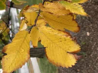 | | 2003 | COLLECTED | | Ponca State Park just north of Ponca approximately 2.75 miles T30N R6E N1/3 SE 1/4 Sec. 3 | 42.60173800, -96.71222100 | 383 | Eastern slopes and ridges of loess bluffs | Wild material | Ulmus thomasii (Rock elm) is an underutilized tree species both in conservation and in the urban landscape. Charles Sprague Sargent (first director of the Arnold Arboretum of Harvard University, Boston, MA) described the wood of Rock Elm as "heavy, hard, very strong and tough, closely grained, and susceptible of receiving a beautiful polish". Historically noted for a variety of uses in woodworking including furniture, heavy agricultural implements, timber frame buildings, pianos, hockey sticks, and hand tools. U. thomasii is extremely drought tolerant, adaptable to very calcareous soils, and compared to U. americana or U. rubra has a very conservative growth rate requiring minimal attention in regards to pruning. Rock elm naturally tends to develop into a nice structural specimen in the landscape, unlike other fast growing U. americana cultivars in the nursery trade needing frequent attention. Rock elm has very fissured bark and is well known for maintaining a strong central leader resulting in a very attractive, pyramidal form. Despite many literature sources stating that "wings" on the stems are a key identifiying characteristic, this trait is not reliable and many genotypes may completely lack "wings" on the stems. While growth habit and morphology of dormant buds (very pointy) are good traits to help aid in identification, fruits are the best way to confirm identity. Fruits are densly pubescent, often described as "inflated" and generally reach maturity a couple weeks after U. rubra and U. americana. U. thomasii inflorescences are rather distinguishable from other Ulmus in being pendulous. Fruits are extremely prized treats for many birds, where fruits are often "robbed" prior to full maturity. Fruits are also highly prized by many other animals such as mice, squirrels, chipmunks, turkeys, etc. and are generally consumed within hours after fruit abscission. The native range of U. thomasii is concentrated in the northeastern United States and into Canada with disjunct populations documented in northwestern Missouri and northwestern Arkansas (Little, E. L. Jr. 1971). In the 1895 Silva of North America (vol. 7) it was stated that, “The value of the wood of the Rock Elm threatens its extinction and most of the large trees have already been cut.” Today, since rock elm is rather rare, especially in areas near the edges of its range, many states list the species as endangered or threatened warranting preservation efforts. This accession was collected in northeast Nebraska (Dixon County) at Ponca State Park representing genetics from the extreme northwestern edge of the species native range and includes genetics (#775-6) from the current (2022) state champion. In an assessment of seedlings from all mother trees sampled (Carstens, J., personal communication, 12 April 2022), #775-4 produces the most vigorous seedlings which also consistently exhibited extremely corky/winged stems on new seedlings. Seedlings from other maternal lines show both winged and non-winged seedlings within the same maternal line and seedlings from some maternal lines have no wings. | 1649925 | Ames 27341 |
| 110 | Ames 27308 | 13 | Dasiphora fruticosa (L.) Rydb. subsp. fruticosa | Iowa, United States | NC7 |  | | 2003 | COLLECTED | 09/14/2003 | North Bear Creek Wildlife Area, Highlandville, N edge of SE 1/4 of SW 1/4 of Section 25, T100N, R7W, Dorchester Quad, Winneshiek County. | 43.44583333, -91.62222222 | 311 | Dolomite cliffs. Half sunny. Edge of sheer cliff with a N to NW aspect. Rock crevices. | Wild material | Small shrubs, 30 to 75 cm tall. | 1649465 | Ames 27308 |
| 111 | Ames 27313 | 22 | Staphylea trifolia L. | Iowa, United States | NC7 |  | | 2003 | COLLECTED | 09/15/2003 | Backbone State Park Cave near Strawberry Point, T90N, R6W NE corner of NW 1/4 of SW 1/4 of Sec. 4, Delaware County | 42.63694444, -91.56194444 | 317 | Alluvium below limestone cave. Nearly full shade. Slight slope w/ SE aspect. Loam soil w/ some stoniness, good drainage | Wild material | Medium to large shrubs. Heavy fruit production. | 1649470 | Ames 27313 |