| 0 | NA 88964 | CF-Qboy-14 | Quercus boyntonii Beadle | Alabama, United States | NA | | | 2023 | COLLECTED | | Nearest town: Gadsden, AL. | 34.05885000, -86.54281000 | 207 | Sandstone glade. Elevation: 681 ft. Aspect: South (170 degrees). | Wild material | 10 acorns received. | 2159025 | NA 88964 |
| 1 | NA 88967 | CF-Qboy-55 | Quercus boyntonii Beadle | Alabama, United States | NA | | | 2023 | COLLECTED | | Nearest town: Gadsden, AL. | 34.05960900, -86.54452900 | 171 | Sandstone glade. Elevation: 562 ft. Aspect: South (180 degrees). | Wild material | 16 acorns received. | 2159028 | NA 88967 |
| 2 | NA 88971 | SC-Qboy-03 | Quercus boyntonii Beadle | Alabama, United States | NA | | | 2023 | COLLECTED | | Nearest town: Pell City, AL. | 33.76418000, -86.24443000 | 262 | Sandstone glade. Elevation: 861 ft. Aspect: South (180 degrees). | Wild material | 10 acorns received. | 2159032 | NA 88971 |
| 3 | NA 88974 | SC-Qboy-25 | Quercus boyntonii Beadle | Alabama, United States | NA | | | 2023 | COLLECTED | | Nearest town: Pell City, AL. | 33.76363000, -86.24612000 | 242 | Sandstone glade. Elevation: 796 ft. Aspect: South-southeast (160 degrees). | Wild material | 5 acorns received. | 2159035 | NA 88974 |
| 4 | NA 88977 | SC-Qboy-53 | Quercus boyntonii Beadle | Alabama, United States | NA | | | 2023 | COLLECTED | | Nearest town: Pell City, AL. | 33.76468400, -86.23974100 | 247 | Sandstone glade. Elevation: 813 ft. Aspect: South (190 degrees). | Wild material | 9 acorns received. | 2159038 | NA 88977 |
| 5 | NA 86519 | P, Thompson 18 | Quercus oglethorpensis W. H. Duncan | Alabama, United States | NA | | | 2020 | COLLECTED | 10/15/2015 | Between timber and hunting properties on a side of County Road 14, ca 3.5 air miles west of Catherine, Alabama. [The GPS coordinates provided, 32.177130 deg. N, 87.522820 deg. W, appear to be slightly east of the collecting site in neighboring Wilcox County. -SBL] | 32.17712000, -87.52281000 | | Mesic roadside. | Wild material | For more information about the project for which this material was collected, see M. Lobdell and P. Thompson, Ex-situ Conservation of _Quercus oglethorpensis_ in Living Collections of Arboreta and Botanical Gardens in _Proceedings of Workshop on Gene Conservation of Tree Species--Banking on the Future_. | 2109228 | NA 86519 |
| 6 | NA 84715 | TDAAR17-015 | Quercus acerifolia (E. J. Palmer) Stoynoff & W. J. Hess ex R. J. Jensen | Arkansas, United States | NA | | | 2017 | COLLECTED | 09/12/2017 | Ouachita National Forest: Porter Mountain area. | 34.38602000, -94.06165000 | 609 | | Wild material | | 1954038 | NA 84715 |
| 7 | NA 82053 | JDC/QM/2014/079/581 | Quercus montana Willd. | Mississippi, United States | NA | | | 2014 | COLLECTED | 09/22/2014 | Mississippi: Tishomingo County; Near J.P. Coleman State Park off County Road 989. | 34.97300100, -88.21763300 | 166 | Pine-oak woods. Growing in association with Liriodendron tulipifera, Pinus sp., Quercus alba, Quercus stellata, Carya sp., Rhus copallinum, Cornus florida, and Cercis canadensis. | Wild material | Optimum timing for harvest. Acorns just starting to drop. Petioles yellow. | 1922354 | NA 82053 |
| 8 | NA 77498 | Q. oglethorpensis x Q. stellata | Quercus hybr. | South Carolina, United States | NA | | | 2008 | COLLECTED | 10/15/2004 | South Carolina, McCormick County, Along Highway 283, circa 2 miles west of Turkey Creek. | | | | Wild material | Quercus oglethorpensis x stellata | 1898076 | NA 77498 |
| 9 | PI 661255 | TX-040 | Daucus pusillus Michx. | Texas, United States | NC7 |  | | 2011 | COLLECTED | 05/28/2010 | Atlanta Cemetery (Plum Creek Cemetery), County Road 135 (Whisper Road), Caldwell County. | 29.65967000, -97.58450000 | 116 | Savannah, cemetery mowed several times most years. Full sun. No slope. Associated with Cnidoscolus texanus, Engelmannia peristenia, Gaillardia pulchella, Helianthus debilis, Monarda punctata, Quercus stellata, and Rudbeckia hirta. | Wild material | | 1862437 | PI 661255 |
| 10 | PI 661256 | TX-041 | Daucus pusillus Michx. | Texas, United States | NC7 |  | | 2011 | COLLECTED | 05/28/2010 | Along Route 713 (Farm to Market Raod), 5 miles south of Rockne, Bastrop County. | 29.84366000, -97.43164000 | 153 | Roadside/savannah. Full sun. No slope. Associated with Gaillardia pulchella, Quercus stellata, Rudbeckia hirta, and Sabatia campestris. | Wild material | | 1862438 | PI 661256 |
| 11 | PI 671849 | FL2010WW-6 | Amphicarpaea bracteata (L.) Fernald | Florida, United States | W6 |  | | 2010 | COLLECTED | 11/09/2010 | Columbia County; Ichetucknee State Park; South entrance; 0.4 miles from entrance; immediately after kiosk, turn left into parking lot; parking lot near maintenance shed; lot perimeter about 15-25 m out | 29.95299000, -82.77148000 | 5 | sand hill; dry, well-drained soil; sunny, open location, edge of open forest dominated by Pinus palustris with an understory of Quercus laevis, Quercus stellata, invasive Quercus laurifolia, Vitis spp, Carya spp. and many annuals | Wild material | Very abundant; prostrate vines; very mature leaves; insect damage; no flowers; few green pods; dry and dehisced pods; small root tuber with fibrous roots extending; adventitious roots from tuber and from lower nodes, growing out to produce other daughter plants; small white ?nodule? on white adventitious roots with more white root growing from it; the main plant often has many satellite plants attached to it. Sample size 750 meters square. | 1854396 | PI 671849 |
| 12 | PI 667472 | TX-51 | Coreopsis sp. | Texas, United States | OPGC |  | | 2010 | COLLECTED | 05/29/2010 | East Central Texas Plain. Wilson County. Approximately 10 miles north of Stockdale. State Highway 123 at Farm-to- Market Road 1681. | 29.37470000, -97.95630000 | 177 | Savannah. Land form: Sand sheet. Land Use: Roadside easment. Geology: Sandy eolian deposits derived from sandstone. Soil Texture: Fine sand. Ecological Site Descriptor: Sandy Loam. | Wild material | Possible Coreopsis nuecensis x C. basalis var. wrightii hybrid; ray petals pale yellow similar to C. nuecensis, taller plants and larger flowers similar to C. basalis var. wrightii. See also TX-63 | 1897328 | PI 667472 |
| 13 | PI 667474 | TX-63 | Coreopsis sp. | Texas, United States | OPGC | | | 2010 | COLLECTED | 05/29/2010 | East Central Texas Plain. Wilson County. Approximately 10 miles north of Stockdale. State Highway 123 at Farm-to- Market Road 1681. | 29.37470000, -97.95630000 | 177 | Savannah. Land form: sand sheet. Land Use: Roadside easment. Geology: Sandy eolian deposits derived from sandstone. Soil Texture:Fine sand. Ecological Site Descriptor: Sandy Loam. | Wild material | Possible Coreopsis nuecensis x C. basalis var. wrightii hybrid; ray petals pale yellow similar to C. nuecensis, taller plants and larger flowers similar to C. basalis var. wrightii. See also TX-51. | 1897339 | PI 667474 |
| 14 | PI 673993 | TX-54 | Coreopsis wrightii (A. Gray) H. M. Parker | Texas, United States | OPGC | 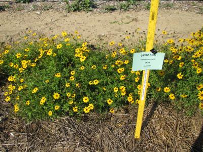 | | 2010 | COLLECTED | 05/29/2010 | East Central Texas Plain. Wilson County. Approximately 5.5 miles northwest of Nixon. Farm-to-Market Road 1681, Near Union Valley Cemetery. | 29.31380000, -97.83930000 | 138 | Savannah. Land form: Stream terrace. Land Use: Roadside easment. Geology: Loamy alluvium. Soil Texture: Loamy sand. Ecological Site Descriptor: Tight sandy Loam. | Wild material | Plants 60 to 75 cm tall; golden yellow ray petals with proximal band of red-brown. | 1897331 | PI 673993 |
| 15 | PI 699412 | TX-52 | Coreopsis nuecensis A. Heller | Texas, United States | OPGC | | | 2010 | COLLECTED | 05/29/2010 | East Central Texas Plain. Wilson County. Approximately 5.5 miles northwest of Nixon. Farm-to-Market Road 1681, Near Union Valley Cemetery. | 29.31380000, -97.83930000 | 138 | Savannah. Land form: Stream terrace. Land Use: Roadside easment. Geology: Loamy alluvium. Soil Texture: Loamy sand. Ecological Site Descriptor: Tight sandy Loam. | Wild material | Plants mown down to about 15 cm tall; Flowers approximately 4 cm in diameter, pale yellow rays with reddish-brown splotches at petal base. | 1897329 | PI 699412 |
| 16 | PI 699444 | TX-50 | Coreopsis wrightii (A. Gray) H. M. Parker | Texas, United States | OPGC | | | 2010 | COLLECTED | 05/29/2010 | East Central Texas Plain. Wilson County. Approximately 10 miles north of Stockdale. State Highway 123 at Farm-to- Market Road 1681. | 29.37470000, -97.95630000 | 177 | Savannah. Land form: Sand sheet. Land Use: Roadside easment. Geology: Sandy eolian deposits derived from sandstone. Soil Texture: Fine sand. Ecological Site Descriptor: Sandy Loam. | Wild material | Plants and flowers to 60 cm; rays yellow with variable proximal red-brown band. Seeds of plants with no ray color band collected as possible C. basalis var. wrightii x C. nuecensis hybrids (TX-51, TX-63). | 1897327 | PI 699444 |
| 17 | PI 657239 | V. fuscatum HD-2007-056 | Vaccinium fuscatum Aiton | Alabama, United States | COR | | | 2007 | COLLECTED | 06/07/2007 | Calhoun County, Anniston Museum of Natural History grounds. Woodland trail 0.5 mile from visitors center. Found in the moister areas, such as dried up stream beds. | 33.69411000, -85.82097000 | 230 | Grey loam - from sandstone. South slope 20 percent. Open woods. Associated with: Quercus nigra, Q. stellata, Q. prinus, Vaccinium arboreum, Pinus taeda and Carya. | Wild material | Kim Hummer, Michael Dossett collected from Alabama.
| 1730134 | PI 657239 |
| 18 | PI 649047 | 15 | Echinacea simulata McGregor | Missouri, United States | NC7 |  | | 2004 | COLLECTED | 10/19/2004 | Roadside along Highway 19, city limits of Cuba, Crawford County. | 38.04761600, -91.39658300 | 314 | Bank of degraded sandstone, along road. 10-20 degrees of slope with a western aspect. Sandy, dry, acidic, chirt and sandstone. | Wild material | | 1668185 | PI 649047 |
| 19 | PI 649084 | 17 | Hypericum punctatum Lam. | Missouri, United States | NC7 |  | | 2004 | COLLECTED | 10/19/2004 | Railroad tracks, roadside along Interstate 44, Crawford County. | 38.03526600, -91.51978000 | 325 | Prairie remnant, partly mowed. 1-5 degrees of slope with a western aspect. | Wild material | | 1668198 | PI 649084 |
| 20 | PI 650941 | 20 | Cuphea viscosissima Jacq. | Missouri, United States | NC7 | | | 2004 | COLLECTED | 10/19/2004 | Railroad tracks, roadside along Interstate 44, Phelps County. | 38.03493300, -91.52031600 | 325 | Prairie remnant. 0-5 degrees of slope with a western aspect. Associated with Agalinis, Baptisia, Cyperus, Juncus, Quercus stellata, and Viburnum dentatum. | Wild material | | 1668180 | PI 650941 |
| 21 | PI 664876 | 16 | Prunella vulgaris L. | Missouri, United States | NC7 | | | 2004 | COLLECTED | 10/19/2004 | Railroad tracks, roadside along Interstate 44, Crawford County. | 38.03526600, -91.51978300 | 325 | Prairie remnant, partly mowed. 1-5 degrees of slope with a western aspect. | Wild material | 15-30 cm tall. | 1668207 | PI 664876 |
| 22 | PI 699919 | 4-21 | Baptisia lactea (Raf.) Thieret var. lactea | Missouri, United States | OPGC |  | | 2004 | COLLECTED | 10/19/2004 | Intersection of Interstate 44 and railroad, Rosati, Phelps County. | 38.03500000, -91.52027778 | 325 | Prairie remnant, partly mown (new owner disked and overseeded with Fescue). 0-5% slope with a western aspect. Wet prairie soil. Associated with Quercus stellata, Baptisia, Juncus, Cyperus, Agalinis, and Viburnum dentatum. | Wild material | 2-3 feet tall. | 1667591 | PI 699919 |
| 23 | PI 618172 | V. stamineum NC96-31-1 | Vaccinium stamineum L. | Alabama, United States | COR | | | 1997 | COLLECTED | | Roadsides and woods edges along county road 7 at Tick Hill Cemetary, 8 miles north of U.S. 29. | 31.92861000, -85.91361000 | 0 | Very dry sandy uplands (were topsoil remains). Much of the vegetation typical for the southern U.S. inner coastal plain. Quercus stellata var. margareta (running post oak) found on top of the hill. Ironstone layer in siol profile. | Wild material | Jim Ballington collection
| 1548792 | PI 618172 |
| 24 | PI 658649 | Index Seminum 42 | Rhus copallinum L. | Pennsylvania, United States | NC7 | | | 1993 | COLLECTED | | Chester County | 39.73710800, -75.93960900 | 120 | Edge of clearing, Chrome Serpentine Barrens, Piedmont Province. | Wild material | | 1086005 | PI 658649 |
| 25 | PI 658653 | Index Seminum 43 | Rhus typhina L. | Pennsylvania, United States | NC7 | | | 1993 | COLLECTED | | Chester County | 39.73333333, -75.93333333 | 120 | Edge of clearing, Chrome Serpentine Barrens, Piedmont Province. | Wild material | | 1086006 | PI 658653 |
| 26 | NA 89158 | 2025RJLSEUS-06 | Cornus florida L. | Alabama, United States | NA | | | 2025 | COLLECTED | 10/01/2025 | Coosa Wildlife Management Area: along the edge of gated dirt road on the west side of Coosa County Road 29, 0.3 kilometers north of Hatchet Creek. | 32.86402200, -86.33871400 | 108 | Plants are growing in part sun to shade on dry-mesic slopes above the road cut on the gated dirt road; most likely a road for access for fire control/forest management. The forest is a combination of deciduous and evergreen with evergreens primarily comprised of Pinus taeda. The habitat was quite dry during this time of year. Slope: 5 to 20 percent. Aspect: North. Soils: The primary soil in the area of this collection is classified as Madison-Louisa Series complex, 15 to 30 percent slopes, moderately eroded (MdE2). The Madison Series soils are very deep, well drained soils with medium runoff found on Piedmont uplands in interstream divides, ridges and side slopes. They are comprised of residuum weathered from felsic or intermediate, high-grade metamorphic or igneous rocks high in content of mica. Slopes range from 2 to 60 percent and soil is typically strongly acidic. Louisa Series soils The Louisa Series soils consist of shallow, somewhat excessively drained soils which formed over mica gneiss and schist bedrock. They occur on Piedmont uplands. Slopes are 6 to 80 percent. This soil is moderately acid. (Source: California Soil Resource Lab/NRCS Official Soil Series Descriptions). Geology: The underlying geology of this area is of Precambrian to Paleozoic origin and characterized as Hatchet Creek Group; Pinchoulee Gneiss Formation. It is characterized by medium to fine-grained migmatitic, locally garnetiferous biotite-feldspar gneiss, commonly saturated with granitic pods. (Source: USGS Alabama Geologic Map Data). | Wild material | | 2193004 | NA 89158 |
| 27 | NA 89115 | TLM25-04a | Hamamelis ovalis S. W. Leonard | Texas, United States | NA | | | 2025 | COLLECTED | 07/10/2025 | State Highway 87 approximately 3.25 kilometers north of the crossroad junction with Texas Recreational Road 255 (RE 255); plants were growing in the narrow buffer woods along the east side of the highway. | 31.12051300, -93.72628100 | 138 | The habitat is an upland mixed coniferous and deciduous woodlands in part to full shade and dry conditions, often under drought stress. Plants seem to always occur on the top of dry ridges or well-drained slopes. Slope: 0 to 1 percent. Aspect: N/A. Soils: The soils of this collection area are classified as Tehran-Letney Association, hilly (TLE) soils. The Tehran Series (55%) consists of deep, somewhat excessively drained, moderately rapidly permeable soils on uplands. They formed in thick loamy and sandy sediments on the Western Coastal Plain. These soils are on gently sloping to moderately steep uplands with slopes ranging from 1 to 20 percent. The Letney Series (30%) consists of deep, well drained, moderately rapidly permeable, upland soils. They formed in thick sandy and loamy sediments of the coastal plains. These soils are on gently sloping to moderately steep uplands with slopes ranging from 1 to 20 percent. Soil pH ranges from 4.5 to 6.0. The minor soil components include Doucette Series (10%) and Boykin Series (5%) soils. (Source: California Soil Resource Lab/NRCS Official Soil Series Descriptions). Geology: The underlying geology of this area is of Oligocene origin and characterized as Catahoula Formation. This formation is extensive and deep in Texas, up to 185 meters thick. In the area of the collection the Catahoula Formation is primarily mudstone and sand. The upper 90-150 meters is mudstone that is tuffaceous, and sandy; also, occasionally, with some bentonitic clay. (Source: USGS Texas Geologic Map Data). | Wild material | | 2191654 | NA 89115 |
| 28 | NA 89095 | SNR2024 | Ilex decidua Walter | Missouri, United States | NA | | | 2024 | COLLECTED | 12/03/2024 | Shaw Nature Reserve: near Shaw Nature Reserve's Trail House. | 38.46697200, -90.81925000 | | Upland site. | Wild material | | 2169943 | NA 89095 |
| 29 | NA 88593 | 2024RJLNJ-001 | Ilex glabra (L.) A. Gray | New Jersey, United States | NA | | | 2024 | COLLECTED | 11/24/2024 | Mullica Township: Both sides of Duerer Street, approximately 0.37 kilometers southeast of 4th Avenue. | 39.55885000, -74.66442500 | 21 | Shade to almost full sun on compacted seasonally moist to temporarily wet areas of a mixed evergreen and deciduous woodland dominated by Pinus rigida. Vegetation of this area is very much defined by small changes in elevation that go from wet to very dry. Ilex glabra remains abundant throughout, though. Slope: N/A. Aspect: N/A. The underlying geology of this area is the Cohansey Formation of middle Miocene origin and comprised of sand, white to yellow with local gravel and clay. It is sometimes locally stained red or orange brown by iron oxides and (or) cemented into large blocks of ironstone. Unweathered clay is typically dark gray, but commonly weathers white where it is interbedded with thin beds of ironstone. Sand is typically medium grained and moderately sorted although it ranges from fine to very coarse grained and from poorly to well sorted. Sand consists of quartz and siliceous rock fragments. Some beds are locally micaceous. Maximum thickness in the map area is about 60 meters; however, thickness is difficult to determine because of the irregular basal contact and extensive post-depositional erosion. (Source: USGS New Jersey Geologic Map Data). The primary soil type in the area of this collection is classified as Mullica Series sandy loam, 0 to 2 percent slopes. These soils are typically coarse-loamy, siliceous, semiactive, and mesic typic humaquepts that are strongly to extremely acidic throughout the profile. The typical solum thickness ranges from 50-150+ cm. These soils are generally considered to be poorly drained. (Source: NRCS Web Soil Survey). | Wild material | | 2169930 | NA 88593 |
| 30 | NA 89091 | 2024RM-TK-004 | Prunus sp. | Florida, United States | NA | | | 2024 | COLLECTED | 09/05/2024 | Blackwater River Wildlife Management Area: on the south side of Boundary Line Road about 0.32 kilometers west of Deaton Bridge Road along an area edged by a barbed wire fence. | 30.68579800, -86.87964300 | 45 | Plants are growing from part-sun to full sun. Plants are growing in an area that is frequently burned with a lot of [Prunus sp. (orig. listed as Prunus alabamensis)] scattered throughout. This habitat is a longleaf pine-wiregrass community with scattered turkey (Quercus laevis) and blackjack oaks (Quercus incana). There is a slight slope downward. The line of [Prunus sp.] goes along a semi-ditch on the side of a dirt road. The plants probably get a bit more water than the plants out in the open forest. The [Prunus sp.] are most often without any other close woody companions. Slope: 0 percent. Aspect: North. Geology: The underlying geology of this area is probably of lower Pliocene age and characterized as the Citronelle Formation. The Citronelle Formation is widespread in the Gulf Coastal Plain. The type section for the Citronelle Formation, named by Matson (1916), is near Citronelle, Alabama. The Citronelle Formation grades laterally, through a broad facies transition, into the Miccosukee Formation of the eastern Florida panhandle. Coe (1979) investigated the Citronelle Formation in portions of the western Florida panhandle. The Citronelle Formation is a siliciclastic, deltaic deposit that is lithologically similar to, and time equivalent with, the Cypresshead Formation and, at least in part, the Long Key Formation (Cunningham et al., 1998) of the peninsula. In the western panhandle, some of the sediments mapped as Citronelle Formation may be reworked Citronelle. The lithologies are the same and there are few fossils present to document a possible younger age. The Citronelle Formation consists of gray to orange, often mottled, unconsolidated to poorly consolidated, very fine to very coarse, poorly sorted, clean to clayey sands. It contains significant amounts of clay, silt and gravel which may occur as beds and lenses and may vary considerably over short distances. Limonite nodules and limonite-cemented beds are common. Marine fossils are rare but fossil pollen, plant remains and occasional vertebrates are found. Much of the Citronelle Formation is highly permeable. It forms the Sand and Gravel Aquifer of the surficial aquifer system. (Source: USGS Florida Geologic Map Data). Soils: The soil of this area is characterized as Lakeland Series Sand, 0 to 5 percent slopes (21). The Lakeland Series consists of very deep, excessively drained, rapid to very rapidly permeable soils on uplands. They formed in thick beds of eolian or marine and/or fluvio-marine sands in the Southern Coastal Plain MLRA (133A), the Carolina and Georgia Sandhills (MLRA 137), the Eastern Gulf Coast Flatwoods (MLRA 152A) and the Atlantic Coast Flatwoods (MLRA 153A). (Source: California Soil Resource Lab/NRCS Official Soil Series Descriptions). EPA Ecoregion (Level III): Southeastern Plains (65). EPA Ecoregion (Level IV): Southern Pine Plains and Hills (65f). | Wild material | Received as Prunus alabamensis; other collections of this material have proven not to be Prunus serotina var. alabamensis, but actually a species of plum; this will likewise be treated as unidentified material until its species can be ascertained. Collectors' notes refer to the plant by the name under which it was collected. | 2169055 | NA 89091 |
| 31 | NA 88812 | TXWL2023-018 | Ilex ambigua Torr. | Texas, United States | NA | | | 2023 | COLLECTED | 12/05/2023 | Davy Crockett National Forest: Forest Service Road 526 roadside. | 31.49017400, -95.22343300 | | Roadside. Shortleaf mixed upland hardwood forest; dry-mesic. | Wild material | | 2165615 | NA 88812 |
| 32 | NA 88806 | TJK2023LA/TX-006 | Vaccinium arboreum Marshall | Texas, United States | NA | | | 2023 | COLLECTED | 11/21/2023 | Interstate 20, westbound, approximately 2.2 miles west of FM (farm-to-market road) 2015 and 0.8 miles east of FM 14. | 32.45250000, -95.26960000 | 10 | Xeric shortleaf pine-post oak-blackjack oak uplands. Slope: flat. Aspect: West. Elevation: 32 feet. | Wild material | | 2159189 | NA 88806 |
| 33 | NA 88668 | TXWL2023-011 | Amorpha paniculata Torr. & A. Gray | Texas, United States | NA | | | 2023 | COLLECTED | 10/02/2023 | Angelina National Forest: Forest Service Road 302A roadside [Note: GPS coordinates are west of FS Road 302A, closer to County Road 348B.] | 31.09190000, -94.29072400 | | Roadside. | Wild material | | 2159043 | NA 88668 |
| 34 | NA 88669 | TXWL2023-012 | Ilex decidua Walter | Texas, United States | NA | | | 2023 | COLLECTED | 10/21/2023 | County Road 3218 en route to Camp Wohaleta, north of Caddo National Grasslands. | 33.75626700, -95.97888900 | | Roadside. | Wild material | | 2159044 | NA 88669 |
| 35 | NA 88670 | TXWL2023-013 | Maclura pomifera (Raf.) C. K. Schneid. | Texas, United States | NA | | | 2023 | COLLECTED | 2023 | Caddo National Grasslands: C-6 near Telephone, Texas [Note: C-6 may refer to Hunter Camp 6 along FM (Farm to Market Road) 409 north of Coffee Mill Lake.] | | | | Wild material | | 2159045 | NA 88670 |
| 36 | Ames 36168 | Mount Magazine | Ptelea trifoliata L. | Arkansas, United States | NC7 |  | | 2023 | COLLECTED | 08/26/2023 | Mount Magazine State Park primarily localized to the northwest rim of the mountain along the trails heading west from Brown's Spring, T6N R25W Sec. 21. | 35.17130900, -93.65582200 | 786 | Top of sky-island mountain. Localized along the rims just above steep cliffs on north facing slopes. | Wild material | Plants in nature ranging from three to fifteen feet in height with peak bloom observed during the first week of May (2023). | 2158787 | Ames 36168 |
| 37 | NA 88599 | RJL2023NC-001 | Ilex decidua Walter | North Carolina, United States | NA | | | 2023 | COLLECTED | 02/18/2023 | Plants growing along a fenceline on a hillside about 10 meters from Interstate 85 (south bound) and approximately 0.65 kilometers south of the North Carolina-Virginia border. | 36.53904800, -78.18822500 | 86 | The plant was growing on the upper shoulder of a slope about 7 meters above the highway in part-shade to sun of an upland, well-drained, dry mesic somewhat disturbed site on the fenceline boundary of Interstate 85 (south bound). The area was originally cleared of all vegetation and now, many years later, native and non-native plant species have aggressively recolonized the area. This early successional habitat is dominated by Juniperus virginiana and Liquidambar styraciflua, as well as, non-native species such as Ligustrum sinense, Lonicera japonica, and Ailanthus altissima. The underlying geology of this area is of Permian/Pennsylvanian origin and characterized as the Granitic Rock Formation. It is characterized by megacrystic to equigranular components and includs Castalia and Wilton intrusives. | Wild material | | 2141480 | NA 88599 |
| 38 | NA 88510 | RJL2022TX-005 | Crataegus marshallii Eggl. | Texas, United States | NA | | | 2022 | COLLECTED | 11/01/2022 | Plants growing along the west side of Texas State Hwy 87 on the edge of the woodlands. Plant is infrequently found, but a regular member of the woodlands as well as forest edge communities along the highway. | 31.15847300, -93.73852000 | 115 | Plants are growing in part-shade to sun on upland dry hills. In shade they survive, but in part-shade to sun they develop excellent flowering and fruiting.
Soils: The underlying geology of this area is of Oligocene origin and characterized as Catahoula Formation. This formation is extensive and deep in Texas, up to 185 meters thick. In the area of the collection the Catahoula Formation is primarily mudstone and sand. The upper 90-150 meters is mudstone that is tuffaceous, and sandy; also, occasionally, with some bentonitic clay.
Source: USGS Texas Geologic Map Data (https://mrdata.usgs.gov/geology/state/sgmc-unit.php?unit=TXQbs%3B0
The primary soil types in the collection area are classified as Letney-Tehran soils. These soils consist of deep, somewhat excessively drained, moderately rapidly permeable soils on uplands. They were formed in thick loamy and sandy sediments on the Western Coastal Plain. The Letney-Tehran soils are on gently sloping to moderately steep uplands with slopes ranging from 1 to 20 percent. They are typically strongly acidic.
Source: NRCS Web Soil Survey (https://websoilsurvey.sc.egov.usda.gov/App/WebSoilSurvey.aspx) | Wild material | | 2139817 | NA 88510 |
| 39 | WLP 2676 | RJL2022NJ-007 | Kalmia latifolia L. | New Jersey, United States | NA | | | 2022 | COLLECTED | 10/24/2022 | Plants growing along Hawkins Bridge Road in Wharton State Forest. Plants are common and frequent throughout the woodlands at this location. | 39.70292400, -74.56106800 | 16 | Plants growing in a mixed Conifer-Broadleaved Evergreen-Deciduous dry to xeric forest habitat in part shade to shade.
Soils: The underlying geology of this area is the Cohansey Formation of middle Miocene origin and comprised of sand, white to yellow with local gravel and clay. It is sometimes locally stained red or orange brown by iron oxides and (or) cemented into large blocks of ironstone. Unweathered clay is typically dark gray, but commonly weathers white where it is interbedded with thin beds of ironstone. Sand is typically medium grained and moderately sorted although it ranges from fine to very coarse grained and from poorly to well sorted. Sand consists of quartz and siliceous rock fragments. Some beds are locally micaceous. Maximum thickness in the map area is about 60 meters; however, thickness is difficult to determine because of the irregular basal contact and extensive post-depositional erosion.
Source: USGS New Jersey Geologic Map Data (https://mrdata.usgs.gov/geology/state/sgmc-unit.php?unit=NJTch%3B1)
The primary soil type in the area of this collection is classified as Lakehurst sand, 0 to 5 percent slopes. Other related soils are found along the collection area; even so, this is the dominant soil in the collecting area of this species. This soil is primarily sandy coastal plain deposition that is moderately well-drained with limited organic matter in the upper horizon. This soil ranges in depth from 0.1-1.5 meters. It is very strongly acidic throughout. It is subject to periods of extreme drought.
Source: NRCS Web Soil Survey (https://websoilsurvey.sc.egov.usda.gov/App/WebSoilSurvey.aspx) | Wild material | | 2139667 | WLP 2676 |
| 40 | WLP 2675 | RJL2022NJ-006 | Kalmia angustifolia L. | New Jersey, United States | NA | | | 2022 | COLLECTED | 10/24/2022 | Plants growing along Hawkins Bridge Road in Wharton State Forest. Plants are common and frequent throughout the woodlands at this location. | 39.70231900, -74.56084200 | 16 | Plants growing in a mixed Conifer-Broadleaved Evergreen-Deciduous dry to xeric forest habitat in part shade to part sun.
Soils: The underlying geology of this area is the Cohansey Formation of middle Miocene origin and comprised of sand, white to yellow with local gravel and clay. It is sometimes locally stained red or orange brown by iron oxides and (or) cemented into large blocks of ironstone. Unweathered clay is typically dark gray, but commonly weathers white where it is interbedded with thin beds of ironstone. Sand is typically medium grained and moderately sorted although it ranges from fine to very coarse grained and from poorly to well sorted. Sand consists of quartz and siliceous rock fragments. Some beds are locally micaceous. Maximum thickness in the map area is about 60 meters; however, thickness is difficult to determine because of the irregular basal contact and extensive post-depositional erosion.
Source: USGS New Jersey Geologic Map Data (https://mrdata.usgs.gov/geology/state/sgmc-unit.php?unit=NJTch%3B1)
The primary soil type in the area of this collection is classified as Lakehurst sand, 0 to 5 percent slopes. Other related soils are found along the collection area; even so, this is the dominant soil in the collecting area of this species. This soil is primarily sandy coastal plain deposition that is moderately well-drained with limited organic matter in the upper horizon. This soil ranges in depth from 0.1-1.5 meters. It is very strongly acidic throughout. It is subject to periods of extreme drought.
Source: NRCS Web Soil Survey (https://websoilsurvey.sc.egov.usda.gov/App/WebSoilSurvey.aspx) | Wild material | | 2139666 | WLP 2675 |
| 41 | WLP 2673 | RJL2022NJ-004 | Lyonia mariana (L.) D. Don | New Jersey, United States | NA | | | 2022 | COLLECTED | 10/24/2022 | Plants growing on both sides of Duerer Street approximately 0.37 kilometers southeast of 4th Avenue, Mullica Township, New Jersey. Plants are common but scattered on both sides of the road at this site. | 39.55730700, -74.66376100 | 22 | Plants grow from part shade to full sun throughout the habit from the upper edges of the ditches through the herbaceous grass dominant buffer and all the way to the part shade of the woodland edge. Plants transition through moist/wet conditions in full sun to quite dry conditions in part shade and seem equally adapted.
Soils: The underlying geology of this area is the Cohansey Formation of middle Miocene origin and comprised of sand, white to yellow with local gravel and clay. It is sometimes locally stained red or orange brown by iron oxides and (or) cemented into large blocks of ironstone. Unweathered clay is typically dark gray, but commonly weathers white where it is interbedded with thin beds of ironstone. Sand is typically medium grained and moderately sorted although it ranges from fine to very coarse grained and from poorly to well sorted. Sand consists of quartz and siliceous rock fragments. Some beds are locally micaceous. Maximum thickness in the map area is about 60 meters; however, thickness is difficult to determine because of the irregular basal contact and extensive post-depositional erosion.
Source: USGS New Jersey Geologic Map Data (https://mrdata.usgs.gov/geology/state/sgmc-unit.php?unit=NJTch%3B1)
The primary soil type in the area of this collection is classified as Mullica sandy loam, 0 to 2 percent slopes. These soils are typically coarse-loamy, siliceous, semiactive, and mesic typic humaquepts that are strongly to extremely acidic throughout the profile. The typical solum thickness ranges from 50-150+ cm. These soils are generally considered to be poorly drained.
Source: NRCS Web Soil Survey (https://websoilsurvey.sc.egov.usda.gov/App/WebSoilSurvey.aspx) | Wild material | | 2139664 | WLP 2673 |
| 42 | NA 88500 | RJL2022NJ-002 | Ilex glabra (L.) A. Gray | New Jersey, United States | NA | | | 2022 | COLLECTED | 10/24/2022 | Mullica Township: both sides of Duerer Street, approximately 0.37 kilometers southeast of 4th Avenue. | 39.55885000, -74.66442500 | 21 | Plants growing in shade to almost full sun on compacted seasonally moist to temporarily wet areas of a mixed evergreen and deciduous woodland dominated by Pinus rigida. Vegetation of this area is very much defined by small changes in elevation that go from wet to very dry. Ilex glabra remains abundant throughout, though. Plants are abundant on the edge of the woodlands as well as the understory of the woodlands. Soils: The underlying geology of this area is the Cohansey Formation of middle Miocene origin and comprised of sand, white to yellow with local gravel and clay. It is sometimes locally stained red or orange brown by iron oxides and (or) cemented into large blocks of ironstone. Unweathered clay is typically dark gray, but commonly weathers white where it is interbedded with thin beds of ironstone. Sand is typically medium grained and moderately sorted although it ranges from fine to very coarse grained and from poorly to well sorted. Sand consists of quartz and siliceous rock fragments. Some beds are locally micaceous. Maximum thickness in the map area is about 60 meters; however, thickness is difficult to determine because of the irregular basal contact and extensive post-depositional erosion. (Source: USGS New Jersey Geologic Map Data). The primary soil type in the area of this collection is classified as Mullica sandy loam, 0 to 2 percent slopes. These soils are typically coarse-loamy, siliceous, semiactive, and mesic typic humaquepts that are strongly to extremely acidic throughout the profile. The typical solum thickness ranges from 50-150+ cm. These soils are generally considered to be poorly drained. (Source: NRCS Web Soil Survey). | Wild material | | 2139663 | NA 88500 |
| 43 | NA 89033 | RJL2022MD-010 | Clethra alnifolia L. | Maryland, United States | NA | | | 2022 | COLLECTED | 09/15/2022 | Plants growing in low woodlands at the end of Greenway Avenue near a boat dock that leads to the Pocomoke River, adjacent to Winter Quarters Golf Course, Pocomoke City. Plants common throughout the wetland area as well as mesic edges of the woodlands. | 38.08305100, -75.56527800 | | Plants growing in the flood plain of the Pocomoke River in shade to part sun of a mixed deciduous and evergreen bottomland habitat about 10 meters from the edge of the golf course fairway. The habitat is a mucky swamp edge habitat next to the Pocomoke River, most of which seems wet year-round and grades slightly upslope to more mesic conditions.
The underlying geology of this area is comprised of Quaternary Deposits of Wisconsin to Holocene origin. The composition is primarily undifferentiated gray to buff sand and gravel, gray to brown lignitic silt and clay, occasional boulders, and rare shell beds. Surficial deposits occur as shell-bearing estuarine clays and silts.
Source: USGS Maryland Geologic Map Data https://mrdata.usgs.gov/geology/state/sgmc-unit.php?unit=MDQdu%3B5
The surface soil profile of this habitat is classified as Puckum Muck which is frequently flooded. These highly saturated soils are found in flats, depressions and swales. The soil reaction of Puckum Muck is extremely acid to strongly acid throughout the profile. The depth to bedrock is generally greater than 150 cm. Wood fragments comprise 0-25%, by volume of the Puckum Muck throughout the profile which includes mostly twigs, branches, logs, or stumps and are 1.5-30 cm in diameter. The composition of these highly saturated soils, are classified as muck (sapric soil material) or mucky peat (hemic soil material) throughout most of the upper 150 cm and may contain thin layers of mucky silt loam, silty clay loam, sandy loam and/or sand.
Source: NRCS Web Soil Survey (https://websoilsurvey.sc.egov.usda.gov/App/WebSoilSurvey.aspx) | Wild material | | 2139598 | NA 89033 |
| 44 | NA 89032 | RJL2022MD-009 | Rhododendron viscosum (L.) Torr. | Maryland, United States | NA | | | 2022 | COLLECTED | 09/15/2022 | Plants growing in low woodlands at the end of Greenway Avenue near a boat dock that leads to the Pocomoke River, adjacent to Winter Quarters Golf Course, Pocomoke City. Plants scattered throughout the wetland area. Infrequent, but regularly found. | 38.08235200, -75.56566500 | 1 | Plants growing in the flood plain of the Pocomoke River in part shade to shade of a mixed deciduous and evergreen bottomland habitat about 10 meters from the edge of the golf course fairway. The habitat is a mucky swamp edge habitat next to the Pocomoke River, most of which seems wet year-round.
The underlying geology of this area is comprised of Quaternary Deposits of Wisconsin to Holocene origin. The composition is primarily undifferentiated gray to buff sand and gravel, gray to brown lignitic silt and clay, occasional boulders, and rare shell beds. Surficial deposits occur as shell-bearing estuarine clays and silts.
Source: USGS Maryland Geologic Map Data https://mrdata.usgs.gov/geology/state/sgmc-unit.php?unit=MDQdu%3B5
The surface soil profile of this habitat is classified as Puckum Muck which is frequently flooded. These highly saturated soils are found in flats, depressions and swales. The soil reaction of Puckum Muck is extremely acid to strongly acid throughout the profile. The depth to bedrock is generally greater than 150 cm. Wood fragments comprise 0-25%, by volume of the Puckum Muck throughout the profile which includes mostly twigs, branches, logs, or stumps and are 1.5-30 cm in diameter. The composition of these highly saturated soils, are classified as muck (sapric soil material) or mucky peat (hemic soil material) throughout most of the upper 150 cm and may contain thin layers of mucky silt loam, silty clay loam, sandy loam and/or sand.
Source: NRCS Web Soil Survey (https://websoilsurvey.sc.egov.usda.gov/App/WebSoilSurvey.aspx) | Wild material | | 2139597 | NA 89032 |
| 45 | NA 88481 | RJL2022MD-002 | Kalmia latifolia L. | Maryland, United States | NA | | | 2022 | COLLECTED | 09/04/2022 | Plants growing at Elkton State Forest along roads and woodlands over a distance of approximately 5 kilometers labelled as the address of 717 Irishtown Rd, North East, MD 21901. Kalmia is very common along the unnamed gravel road as well as the understory of the upland woodlands. | 39.58852900, -75.90452900 | 60 | Plants are growing in a mesic to dry, well-drained habitat of mixed deciduous and evergreen woodlands comprised primarily of acid-loving plants. Plants are growing in shade to part shade along the unnamed road as well as the woodlands. The soils in the collection area are generally described as a complex series of fluviomarine deposits. The soils range from a thin loam layer at the surface to varying levels of loam to sandy loam and/or extremely gravelly sandy clay loam strata, depending upon geographical location (ie. Hillslope summits, slopes, footslopes, swales, etc.). The primary soil types in the collection area are classified as Russett-Christiana-Hambrook Complex and/or Sassafras and Croom Soils; though, others may intersect and overlay in specific areas. | Wild material | | 2139360 | NA 88481 |
| 46 | Ames 35945 | AS/ML/2022/012/143 | Monarda lindheimeri Engelm. & A. Gray | Texas, United States | NC7 |  | | 2022 | COLLECTED | 08/06/2022 | Located approximately 6.5 miles north of Columbus along FM 109 just north of Redgate Creek and also area 1.75 miles to the west along Brune Lane. | 29.80034600, -96.53240000 | 73 | Woodland edges and fencelines. | Wild material | | 2140535 | Ames 35945 |
| 47 | Ames 35948 | AS/ML/2022/017/147 | Monarda lindheimeri Engelm. & A. Gray | Texas, United States | NC7 |  | | 2022 | COLLECTED | 08/06/2022 | Located near Grimes County line along highway 6 approximately 6.5 miles north of Hempstead. | 30.22891300, -96.05532600 | 68 | Woodland edge. | Wild material | Plants in nature measuring up to approximately 3.0-3.5' in height with very long internodes. Extreme variation noted on stem color from green, to purple to green with purple edges. | 2140538 | Ames 35948 |
| 48 | Ames 35950 | AS/ML/2022/019/150 | Monarda lindheimeri Engelm. & A. Gray | Texas, United States | NC7 |  | | 2022 | COLLECTED | 08/06/2022 | Located approximately 1.55 miles west of Dobbin on highway 105 just east of Caney Creek. | 30.35623600, -95.79980200 | 80 | Woodland edge. | Wild material | | 2140540 | Ames 35950 |
| 49 | Ames 35951 | AS/ML/2022/020/151 | Monarda lindheimeri Engelm. & A. Gray | Texas, United States | NC7 |  | | 2022 | COLLECTED | 08/07/2022 | Located northwest of Navasota approximately 5.60 miles along Old Highway 6. | 30.44628200, -96.15333200 | 67 | Powerline cut. | Wild material | Accession consisting of both white flowering specimens and multi-colored (pinkish) flowering specimens. Inventory 01 represented as rather robust plants up to 40" tall that display a rather to somewhat clump type growth habit (possibly due to growing in more of a prairie habitat/full sun), but also includes adjacent specimens that are rhizomatous. Inventory 02 represents a more rhizomatous growth habit and shorter in height (e.g. less than 20" tall). Plants sampled ranging from 1.0-4.5' in height. | 2140541 | Ames 35951 |
| 50 | Ames 35953 | AS/ML/2022/022/153 | Monarda lindheimeri Engelm. & A. Gray | Texas, United States | NC7 |  | | 2022 | COLLECTED | 08/07/2022 | Located 4.98 miles west of Millican on the south side of FM 2154 Rd. | 30.50280100, -96.28483800 | 94 | Roadside, railroad right-of-way. | Wild material | Population extending just over 2.00 miles represented as very vigorous, rhizamatous specimens. In comparison to other M. lindheimeri noted in Texas in 2022, this population is one of the earliest flowering populations, nearly 2-3 weeks earlier typically peaking in mid-April. In 2022, population peaked flower on 18 April. | 2140543 | Ames 35953 |
| 51 | Ames 35954 | AS/ML/2022/023/154 | Monarda lindheimeri Engelm. & A. Gray | Texas, United States | NC7 |  | | 2022 | COLLECTED | 08/07/2022 | Located just southwest of College Station on both Los Robles Dr and White Creek Rd. | 30.57630900, -96.38686600 | 91 | Roadside, woodland edge and savannah. | Wild material | Very rhizamatous specimens noted in nature. In comparison to other M. lindheimeri noted in Texas in 2022, this population is one of the earliest flowering populations, nearly 2-3 weeks earlier typically peaking in mid-April. In 2022, population peaked flower on 18 April. | 2140544 | Ames 35954 |
| 52 | Ames 35957 | AS/ML/2022/026/157 | Monarda luteola Singhurst & W. C. Holmes | Texas, United States | NC7 |  | | 2022 | COLLECTED | 08/05/2022 | Located north of Palestine approximately 3.60 miles on AN Country Road 404 (west side) just 0.7 miles north from intersection with AN Country Road 403 | 31.81051200, -95.63928400 | 185 | Roadside, woodland edge. | Wild material | Lemon-scented foliage when crushed. Population in nature noted slightly prior to peak flowering on 28 April (2022) at collection site. | 2140547 | Ames 35957 |
| 53 | WLP 2576 | RJL2022-001 | Amelanchier arborea (F. Michx.) Fernald | Maryland, United States | NA | | | 2022 | COLLECTED | 05/25/2022 | Plants growing in open woodlands and part shade along unnamed Elkton State Forest gravel road over a distance of approximately 5 kilometers labelled as the address of 717 Irishtown Rd, North East, MD 21901. | 39.58089500, -75.91505900 | 73 | Plants are found regularly but scattered along the unnamed gravel road as well as in open understory of the upland woodlands. Plants growing in a mesic to dry, well-drained habitat of mixed deciduous and evergreen woodlands comprised primarily of acid-loving plants. Plants are growing in part shade and open understory shade. The soils in the collection area are generally described as a complex series of fluviomarine deposits. The soils range from a thin loam layer at the surface to varying levels of loam to sandy loam and/or extremely gravelly sandy clay loam strata, depending upon geographical location (ie. Hillslope summits, slopes, footslopes, swales, etc.). The primary soil types in the collection area are classified as Russett-Christiana-Hambrook Complex and/or Sassafras and Croom Soils; though, others may intersect and overlay in specific areas. | Wild material | | 2138095 | WLP 2576 |
| 54 | NA 86933 | PCCKY16-024 | Viburnum deamii (Rehder) Bush | Ohio, United States | NA | | | 2021 | COLLECTED | 09/07/2019 | Lynx Township: Edge of Appalachia Preserve System: The E. Lucy Braun Lynx Prairie Preserve. | 38.76479000, -83.40996000 | 266 | Oak-hickory woodland over Devonian shale (Ohio shale). Slope: 0 degrees. Aspect: Northwest. | Wild material | Full name as recorded at U.S. National Arboretum: Viburnum dentatum var. deamii. See NA 86224 for original wild-collected seed received from the Arnold Arboretum in 2019. | 2155046 | NA 86933 |
| 55 | Ames 36047 | CBG-10076 | Helianthus divaricatus L. | Oklahoma, United States | NC7 | | | 2021 | | | | | | | Wild material | | 2120050 | Ames 36047 |
| 56 | Ames 36062 | CBG-10584 | Linum sulcatum Riddell | Illinois, United States | NC7 | | | 2021 | | | | | | | Wild material | Plant numbers sampled estimated. | 2120175 | Ames 36062 |
| 57 | NA 88199 | CBG-10062 | Callicarpa americana L. | Oklahoma, United States | NA | | | 2021 | | | | | | | Wild material | | 2120043 | NA 88199 |
| 58 | NA 88332 | CBG-10580 | Hypericum prolificum L. | Illinois, United States | NA | | | 2021 | | | | | | | Wild material | Plant numbers sampled estimated. | 2120171 | NA 88332 |
| 59 | OPGC 8289 | CBG-10186 | Verbena hastata L. | Oklahoma, United States | OPGC | | | 2021 | | | | | | | Wild material | | 2120055 | OPGC 8289 |
| 60 | OPGC 8339 | CBG-10556 | Anemone virginiana L. | Illinois, United States | OPGC | | | 2021 | | | | | | | Wild material | GPS coordinates incomplete. | 2120152 | OPGC 8339 |
| 61 | OPGC 8344 | CBG-10576 | Gillenia stipulata (Muhl. ex Willd.) Nutt. | Illinois, United States | OPGC | | | 2021 | | | | | | | Wild material | plant numbers sampled estimated. | 2120167 | OPGC 8344 |
| 62 | OPGC 8348 | CBG-10581 | Hieracium scabrum Michx. | Illinois, United States | OPGC | | | 2021 | | | | | | | Wild material | Plant numbers sampled estimated. | 2120172 | OPGC 8348 |
| 63 | OPGC 8355 | CBG-10605 | Solidago nemoralis Aiton | Illinois, United States | OPGC | | | 2021 | | | | | | | Wild material | Also collected elsewhere in SCCA. Plant numbers sampled estimated. | 2120226 | OPGC 8355 |
| 64 | OPGC 8356 | CBG-10606 | Solidago ulmifolia Muhl. ex Willd. | Illinois, United States | OPGC | | | 2021 | | | | | | | Wild material | Plant numbers sampled estimated. | 2120227 | OPGC 8356 |
| 65 | W6 59206 | CBG-10504 | Muhlenbergia sobolifera (Muhl. ex Willd.) Trin. | Illinois, United States | W6 | | | 2021 | | | | | | | Wild material | | 2120201 | W6 59206 |
| 66 | W6 59222 | CBG-10529 | Gratiola neglecta Torr. | Illinois, United States | W6 | | | 2021 | | | | | | | Wild material | Plant numbers estimated. | 2120137 | W6 59222 |
| 67 | W6 59238 | CBG-10552 | Agrostis perennans (Walter) Tuck. | Illinois, United States | W6 |  | | 2021 | | | | | | | Wild material | Collection date assumption. Plant numbers estimated. | 2120151 | W6 59238 |
| 68 | W6 59243 | CBG-10560 | Cinna arundinacea L. | Illinois, United States | W6 | | | 2021 | | | | | | | Wild material | Plant numbers estimated. | 2120155 | W6 59243 |
| 69 | W6 59278 | CBG-10602 | Schizachyrium scoparium (Michx.) Nash | Illinois, United States | W6 | | | 2021 | | | | | | | Wild material | Plant numbers sampled estimated. | 2120187 | W6 59278 |
| 70 | NA 86846 | MSD19-001 | Acer pycnanthum K. Koch | Honshu, Japan | NA | | | 2021 | COLLECTED | 05/23/2019 | Gifu Prefecture: Nakatsugawa: farm of Mr. Asano. | 35.49533000, 137.45438000 | 270 | Mesic woods adjacent rice paddies; much of overstory was Cryptomeria (planted); poor drainage throughout; most trees growing at edges where light was abundant. Soil highly organic and shallow. | Wild material | Full name as recorded at U.S. National Arboretum: Acer pycnanthum. Plants picked up by USNA staff on 6/23/2021. | 2154981 | NA 86846 |
| 71 | Ames 35660 | Kiamichi Mountains | Ptelea trifoliata L. | Oklahoma, United States | NC7 | | | 2021 | COLLECTED | 07/19/2018 | Kiamichi Mountains of Ouachita National Forest along Road 6025 just west of State Highway 259, T2N R25E SW 1/4 NE 1/4 SW 1/4 Sec. 27 | 34.61314900, -94.67035700 | 651 | Open, dry ridgetop, rocky roadside. | Wild material | Specimens sampled measuring approximately 20-25' in height. | 2114985 | Ames 35660 |
| 72 | OPGC 7463 | CBG-8629 | Delphinium tricorne Michx. | Idaho, United States | OPGC |  | | 2019 | | | | | | | Wild material | | 2092684 | OPGC 7463 |
| 73 | W6 56613 | CBG-8802 | Carex typhina Michx. | Illinois, United States | W6 |  | | 2019 | | | | | | | Wild material | | 2092712 | W6 56613 |
| 74 | Ames 34307 | JDC/EP/2018/051/864 | Echinacea paradoxa (Norton) Britton | Missouri, United States | NC7 |  | | 2018 | COLLECTED | 07/16/2018 | Auxvasse Natural Area located 8.44 miles southeast of Fulton, T46N R8W S 1/4 Sec. 9, Callaway County | 38.76733000, -91.82958500 | 205 | Dolomite glade. Large (110 acres) and exceptionally diverse (220 plant species identified). According to local MDC biologists, this is one of the best glades north of the Missouri River in Missouri. Northern most, native population of Echinacea paradoxa in Missouri. | Wild material | Plants reached peak flower on 30 May 2018. Specimens ranged from 2.0-4.0' in height. | 1964614 | Ames 34307 |
| 75 | Ames 34310 | JDC/MB/2018/050/863 | Monarda bradburiana L. C. Beck | Missouri, United States | NC7 |  | | 2018 | COLLECTED | 07/16/2018 | Auxvasse Natural Area located 8.44 miles southeast of Fulton, T46N R8W S 1/4 Sec. 9, Callaway County | 38.76733000, -91.82958500 | 205 | Dolomite glade. Large (110 acres) and exceptionally diverse (220 plant species identified). According to local MDC biologists, this is one of the best glades north of the Missouri River in Missouri. | Wild material | Plants measuring circa 1.0' in height. Peak flowering occurred around 18 May 2018. Seeds likely reached full maturity around first week in July (2018). | 1964617 | Ames 34310 |
| 76 | Ames 34311 | JDC/ML/2018/029/842-A | Monarda luteola Singhurst & W. C. Holmes | Arkansas, United States | NC7 |  | | 2018 | COLLECTED | 07/17/2018 | Washburn Mountain Range located 8.10 miles south, southwest of Charleston on Fort Chaffee Military Base, T6N R29W NE 1/4 SW 1/4 Sec. 16, Sebastian County | 35.19071800, -94.09287200 | 290 | Open, dry woods. | Wild material | Plants with lemon scent, pubescent stems and leaves with faint yellow flowers measuring circa 2.0-2.5' in height. Plants likely reached peak flower on 18 May 2018. Seeds likely reached full maturity around first week in July (2018). | 1964618 | Ames 34311 |
| 77 | Ames 34313 | JDC/ML/2018/034/847 | Monarda luteola Singhurst & W. C. Holmes | Texas, United States | NC7 |  | | 2018 | COLLECTED | 07/18/2018 | Private property located 4.35 miles south, southwest of Daingerfield off County Road 2215. Locally known as "Kennedy Mountain", Morris County | 32.97217700, -94.74721600 | 152 | Open, dry woods, edge of woods and open clear cut areas with prairie grasses/forbes. | Wild material | Plants with lemon scent, pubescent stems and leaves with faint yellow flowers measuring circa 1.0-2.5' in height. Plants likely reached peak flower on 15 May 2018. At time of collection, plants had 2-4" of stem dieback from seed head. Seeds likely reached full maturity around first week in July (2018). Collection represents genetics from where Monarda luteola holotype (W.C. Holmes #14012 & J.R. Singhurst) was collected 24 May 2008. | 1964620 | Ames 34313 |
| 78 | Ames 34314 | JDC/ML/2018/037/850 | Monarda luteola Singhurst & W. C. Holmes | Texas, United States | NC7 |  | | 2018 | COLLECTED | 07/18/2018 | Daingerfield State Park located 1.70 miles southeast of Daingerfield. Population centered around Mountain View Trail (northwest corner of state park) on ridetop/high knoll, Morris County | 33.01175900, -94.70478100 | 156 | Open, dry woods. | Wild material | Plants with lemon scent, pubescent stems and leaves with faint yellow flowers measuring circa 0.5-1.0' in height or less. Plants likely reached peak flower on 12 May 2018. Seed heads rather small likely due to heavy shade from oak and pine. Plants seem to be rather stressed from competition and poor substrate for supporting plant growth. | 1964621 | Ames 34314 |
| 79 | Ames 34315 | JDC/ML/2018/039/852 | Monarda luteola Singhurst & W. C. Holmes | Texas, United States | NC7 |  | | 2018 | COLLECTED | 07/18/2018 | Located 4.10 miles east of Mineola on west side of County Road 2650 just 0.88 miles north of intersection with FM 1801, Wood County | 32.66918400, -95.41726400 | 139 | Very diverse vegetation. Roadside. | Wild material | Plants with lemon scent, pubescent stems and leaves with faint yellow flowers measuring circa 1.0-2.5' in height. Plants likely reached peak flower on 15 May 2018. Seeds likely reached full maturity around first week in July (2018). | 1964622 | Ames 34315 |
| 80 | Ames 34316 | JDC/ML/2018/040/853 | Monarda luteola Singhurst & W. C. Holmes | Texas, United States | NC7 |  | | 2018 | COLLECTED | 07/18/2018 | Located between 7.7 and 8.60 miles east of Mineola locally known as "Salesmanship Club Property" just north of County Road 2694, Wood County | 32.67938700, -95.34237100 | 149 | Open, dry woods, edge of woods and open clear cut areas with prairie grasses/forbes. | Wild material | Plants with lemon scent, pubescent stems and leaves with faint yellow flowers measuring circa 2.0-2.5' in height. Plants likely reached peak flower on 10 May 2018. Seeds likely reached full maturity around first week in July (2018). | 1964623 | Ames 34316 |
| 81 | Ames 34318 | JDC/ML/2018/042/855 | Monarda luteola Singhurst & W. C. Holmes | Texas, United States | NC7 |  | | 2018 | COLLECTED | 07/18/2018 | Tyler State Park located 8.40 miles north of Tyler. Population concentrated around Blackjack Nature Trail (southwest corner of state park), Smith County | 32.46893000, -95.30335000 | 163 | Open, dry woods. | Wild material | Plants with lemon scent, pubescent stems and leaves with faint yellow flowers measuring circa 1.0-2.5' in height. Plants likely reached peak flower on 10 May 2018. Seeds likely reached full maturity around first week in July (2018). | 1964625 | Ames 34318 |
| 82 | Ames 34319 | JDC/ML/2018/057/870 | Monarda luteola Singhurst & W. C. Holmes | Texas, United States | NC7 |  | | 2018 | COLLECTED | 07/18/2018 | Just west of Avinger on north side of highway 155 in powerline cut between CR 1650 and CR 1651 (just 1.0 mile west of intersection of higwhay 49 and highway 155), Cass County | 32.89669900, -94.56962800 | 112 | Infrequently mowed, clear cut area for powerline. | Wild material | Plants with lemon scent and pubescent stems and leaves measuring 1.0-3.0' in height. Noted extreme variation across population with some plants exhibiting both heavily pubescent and others with minimally pubescent stems. Plants not observed during flower, but all specimens sampled believed to be M. luteola. Seeds likely reached full maturity around first week in July (2018). | 1964626 | Ames 34319 |
| 83 | Ames 34320 | JDC/MR/2018/058/871 | Monarda russeliana Nutt. ex Sims | Oklahoma, United States | NC7 |  | | 2018 | COLLECTED | 07/19/2018 | Kiamichi Mountains of Ouachita National Forest along Road 6025 just west of highway 259, T2N R25E S 1/2 Sec. 27 and S 1/2 Sec. 28 Le Flore County. | 34.61320100, -94.66641200 | 651 | Open, dry, rocky woods. | Wild material | Petite plants with only 1-3 stems per plant ranging from 1.0-1.5' in height. At time of collection (19 July 2018) peduncle showing 1-2" of dead/brown tissue. Leaves twice as long (or more) as wide. Generally three pairs of opposite leaves per stem. Slight pubescence on leaves with 1-2 mm petiole. Leaves rather flat. Seeds likely reached peak maturity around first week in July. | 1964627 | Ames 34320 |
| 84 | Ames 34321 | JDC/MR/2018/061/874 | Monarda russeliana Nutt. ex Sims | Oklahoma, United States | NC7 |  | | 2018 | COLLECTED | 07/19/2018 | On the northwest side of Wister Lake along the north side of Wister Lake MGMT Road, T5N R24E NW 1/4 NW 1/4 and NE 1/4 NW 1/4 Sec. 6, Le Flore County. | 34.93915700, -94.81967400 | 160 | Open, dry, rocky woods. | Wild material | Petite plants with only 1-3 stems per plant ranging from 1.0-1.5' in height. At time of collection (19 July 2018) peduncle showing 1-2" of dead/brown tissue. Leaves twice as long (or more) as wide. Generally three pairs of opposite leaves per stem. Slight pubescence on leaves with 1-2 mm petiole. Leaves rather flat. Seeds likely reached peak maturity around first week in July. | 1964628 | Ames 34321 |
| 85 | OPGC 5470 | JDC/BN/2018/056/869 | Baptisia nuttalliana Small | Arkansas, United States | OPGC |  | | 2018 | COLLECTED | 07/17/2018 | Located circa 2.60 miles northwest of Brightstar off Miller Road 159, Miller Road 74, Miller Road 75, Miller Road 154 and highway 237, Miller County | 33.14091000, -94.02229000 | 109 | Roadside. Edges of woods. | Wild material | Plants essentially all black with seeds past maturity by approximately 2-3 weeks, plants starting to break off at ground level and fruiting capsules starting to split at time of collection (17 July 2018). Seed quality rather poor at time of collection largely due to weevils. | 1964612 | OPGC 5470 |
| 86 | Ames 34302 | JDC/EP/2018/044/857 | Echinacea paradoxa (Norton) Britton | Missouri, United States | NC7 |  | | 2018 | COLLECTED | 07/03/2018 | Drury-Mincy Conservation Area just off Gunnison Road (west side) located approximately 8.5 miles southeast of Branson, T22N R20W W 1/4 SE 1/4 Sec. 16, Taney County | 36.55268100, -93.10969300 | 302 | Open, dry glade. | Wild material | | 1964609 | Ames 34302 |
| 87 | Ames 34303 | JDC/MB/2018/047/860 | Monarda bradburiana L. C. Beck | Missouri, United States | NC7 |  | | 2018 | COLLECTED | 07/03/2018 | Drury-Mincy Conservation Area just off Gunnison Road (west side) located approximately 8.5 miles southeast of Branson, T22N R20W W 1/4 SE 1/4 Sec. 16, Taney County | 36.55268100, -93.10969300 | 302 | Open, dry glade. | Wild material | | 1964610 | Ames 34303 |
| 88 | Ames 34204 | JDC/ML/2018/030/843 | Monarda luteola Singhurst & W. C. Holmes | Arkansas, United States | NC7 |  | | 2018 | COLLECTED | 05/22/2018 | Located 2.62 miles northwest of Brightstar off Miller Road 159 just 0.54 miles north of junction with state highway 160, Miller County | 33.14091000, -94.02229000 | 109 | Roadside. Open woods. | Wild material | Plants with lemon scent, pubescent stems and leaves with faint yellow flowers measuring circa 2.0' in height. Leaves longer than internodes. Plants likely reached peaked flower around 16 May 2018. Seeds likely reached full maturity around first week in July (2018). | 1963387 | Ames 34204 |
| 89 | Ames 34206 | JDC/RA/2018/045/858 | Rhus aromatica Aiton | Missouri, United States | NC7 |  | | 2018 | COLLECTED | 05/24/2018 | Drury-Mincy Conservation Area along Bear Cave Trail just off Gunnison Road, T22N R20W NW 1/4 Sec. 21. | 36.54492100, -93.11595600 | 330 | Glade. Open woods. | Wild material | Plants ranging in size (variable due to recent prescribed burning) from 2-6' in height. Fruit maturity variable at time of collection (25 May 2018) from bright red and readily shattering to rather green. | 1963389 | Ames 34206 |
| 90 | W6 53021 | CBG-6587 | Carex albicans Willd. ex Spreng. var. albicans | Illinois, United States | W6 |  | | 2017 | | | | | | | Wild material | Carex albicans var. albicans | 1954772 | W6 53021 |
| 91 | Ames 33976 | JDC/BX/2017/029/783 | Baptisia aberrans (Larisey) Weakley | Tennessee, United States | NC7 |  | | 2017 | COLLECTED | 07/07/2017 | Just east of Murfreesboro off Factory Road, Rutherford County. | 35.85458800, -86.29682300 | 207 | Remnant cedar glade recently cleared of woody vegetation resulting in flowering of numerous native plants. | Wild material | Plants in cultivation (central Iowa) measuring 0.16 m tall x 0.42 m wide with leaflets oriented in a vertical plane; petioles 2.0-3.0 mm long; leaflets 2.2-2.3 cm long and 1.1-1.2 cm wide; fertile stems 0.42 m tall with leafy branches spreading horizontally. Flowers dark purple peaking in late May (central Iowa) when grown in cultivation. | 1950059 | Ames 33976 |
| 92 | Ames 33757 | Ames 33757 | Monarda bradburiana L. C. Beck | Illinois, United States | NC7 | _thumbnail.jpg "Click for 3 image(s) for this accession.") | | 2016 | COLLECTED | 10/03/2016 | Shoal Creek Conservation Area approximately 3.5 miles northeast of Litchfield, T9N R5W NW 1/4 SW 1/4 Sec. 25 Montgomery County. | 39.19444400, -89.59388900 | 194 | Barrens complex. Southern Illinois Tillplain. Clay and silt sandstone | Wild material | | 1943155 | Ames 33757 |
| 93 | Ames 33759 | Ames 33759 | Monarda punctata L. | Missouri, United States | NC7 | _thumbnail.JPG "Click for 5 image(s) for this accession.") | | 2016 | COLLECTED | 09/26/2016 | Near Missouri County Highway AA approximately 6.0 miles southwest of Bertrand, T26N R14E SE 1/4 SW 1/4 Sec. 34. New Madrid County. | 36.84930000, -89.53180000 | 92 | Degraded remnant sand prairie/savanna, open grassland. Deep, loamy sand. | Wild material | | 1943157 | Ames 33759 |
| 94 | Ames 32923 | JDC/FQ/2015/038/694 | Fraxinus quadrangulata Michx. | Oklahoma, United States | NC7 |  | | 2015 | COLLECTED | 05/22/2015 | T19 R12E N 1/4 Sec. 18 and extreme SE 1/4 Sec. 7 Tulsa County. Chandler Park. | 36.13235400, -96.07376000 | 264 | Rocky, very shallow soils on north and northwest-facing slopes. Growing in association with Fraxinus americana, Cotinus obovatus, Celtis sp., Cornus sp., Ulmus sp., Cercis canadensis, Juniperus virginiana, Quercus muehlenbergii, Smilax sp., Toxicodendron radicans, Quercus texana, and Quercus stellata (chlorotic). | Wild material | | 1926265 | Ames 32923 |
| 95 | WLP 1099 | JDC/CO/2015/031/687 | Cotinus obovatus Raf. | Arkansas, United States | NA |  | | 2015 | COLLECTED | 05/20/2015 | T16N R10W SW 1/4 Sec. 35 and SE 1/4 Sec. 34 and also T15N R10W S 1/2 Sec. 3 Izard County. Brandenburg Mountain area, along highway 9 between Allison and Melbourne. | 35.99358500, -92.02874700 | 170 | Rocky, very shallow soils. Growing on both north, southeast, and west-facing slopes in association with Quercus muehlenbergii, Quercus stellata, Juniperus virginiana, Cercis canadensis, Delphinium carolinianum, Echinacea sp., Fraxinus americana, and Yucca sp. | Wild material | | 1926261 | WLP 1099 |
| 96 | WLP 1100 | JDC/CO/2015/034/690 | Cotinus obovatus Raf. | Arkansas, United States | NA | | | 2015 | COLLECTED | 05/21/2015 | T10N R20W SE 1/4 NW 1/4 Sec. 6 Pope County. Long Pool Recreation Area between Big Piney Creek and Newton Hill. | 35.54962900, -93.15052600 | 229 | Rocky, likely somewhat acidic substrate on north-facing slopes. Growing in association with Acer saccharum, Juniperus virginiana, Vaccinum sp., Quercus stellata, Rhododendron spp, Viburnum rufidulum, Castanea ozarkensis, Amelanchier sp., Ostrya virginiana, Nyssa sylvatica, Quercus alba, and Pinus sp.. | Wild material | | 1926262 | WLP 1100 |
| 97 | WLP 1102 | JDC/CO/2015/037/693 | Cotinus obovatus Raf. | Oklahoma, United States | NA |  | | 2015 | COLLECTED | 05/22/2015 | T19 R12E N 1/4 Sec. 18 and extreme SE 1/4 Sec. 7 Tulsa County. Chandler Park. | 36.13366000, -96.06623100 | 264 | Rocky, very shallow soils on north and northwest-facing slopes. Growing in association with Fraxinus americana, Fraxinus quadrangulata, Celtis sp., Cornus sp., Ulmus sp., Cercis canadensis, Juniperus virginiana, Quercus muehlenbergii, Smilax sp., Toxicodendron radicans, Quercus texana, and Quercus stellata (chlorotic). | Wild material | | 1926264 | WLP 1102 |
| 98 | W6 49517 | CBG-2452 | Koeleria macrantha (Ledeb.) Schult. | Illinois, United States | W6 |  | | 2015 | | | | | | | Wild material | | 1925997 | W6 49517 |
| 99 | NA 82643 | NA 82643 | Lonicera sempervirens L. | Texas, United States | NA | | | 2015 | COLLECTED | 07/20/2014 | East side of Texas Route 87 approximately 0.52 miles south of Trout Creek, Texas. | 30.61156000, -93.80506000 | 21 | Southwest-facing edge of mature woodland in part to full sun; well-drained, seasonally moist soils that are sandy loam; surface has an excellent organic litter layer. | | | 1952603 | NA 82643 |
| 100 | NA 82648 | NA 82648 | Viburnum acerifolium L. | Texas, United States | NA | | | 2015 | COLLECTED | 08/31/2013 | West side of the road along Texas Route 87 north of Burkeville, Texas. | 31.11950000, -93.72656000 | 141 | Dry, acidic woodlands in full shade beneath trees; soils sandy loam and are very loose and drought prone. | Wild material | | 1953129 | NA 82648 |
| 101 | Ames 32903 | APS/GD/2015/031/213 | Gymnocladus dioicus (L.) K. Koch | Oklahoma, United States | NC7 |  | | 2015 | COLLECTED | 03/19/2015 | Osage County: Arkansas River watershed area known as Souters Bend, T21N R7E. Keystone Wildlife Management Area (John Lowery Unit) approximatley 3 miles west of Cleveland. | 36.30185300, -96.53051000 | 222 | Floodplain, but one specimen sampled was located on dry, rocky (large boulders) bluff. | Wild material | | 1925369 | Ames 32903 |
| 102 | Ames 32904 | APS/GD/2015/032/214 | Gymnocladus dioicus (L.) K. Koch | Oklahoma, United States | NC7 |  | | 2015 | COLLECTED | 03/19/2015 | Osage County: Sand Creek watershed area, T27N R8E SE 1/4 NW 1/4 Sec. 10. Tallgrass Prairie Preserve approximately 13 miles northwest of Pawhuska. | 36.83425300, -96.43091600 | 307 | Dry, rocky outcroppings and floodplain. | Wild material | | 1925370 | Ames 32904 |
| 103 | NA 83068 | NA 83068 | Philadelphus pubescens Loisel. | Arkansas, United States | NA | | | 2015 | COLLECTED | 10/06/2014 | Mount Magazine State Park; Brown's Spring Picnic Area trail. | 36.16768000, -93.66583000 | 796 | Moist bluff line community, growing in moist organic soil layer over rocks. | | | 1952927 | NA 83068 |
| 104 | DPRU 3200 | JDC/PA/2014/082/584 | Prunus americana Marshall | Mississippi, United States | DAV | | | 2014 | COLLECTED | 09/22/2014 | Tishomingo County, Mississippi - Extreme northeast corner of Tishomingo County near J.P. Coleman S.P. | 34.98170000, -88.20449700 | 202 | Dry, pine-oak-hickory woods. Growing in association with Pinus sp., Liquidambar styraciflua, Fraxinus americana, Rhus typhina, Acer rubrum, Quercus stellata, and Carya sp. | Wild material | Fruits perfectly round, very ripe, and pinkish-red in color. Actively dropping at time of collection. The only specimens of this species noted during entire trip throughout northern Mississippi, parts of Arkansas, and northwest Alabama. There were two specimens a few feet from each other, but I suspect they were not genetically unique from each other due to the suckering nature of the species. Considering there was decent fruit production there must have been another Prunus sp. nearby. | 1921307 | DPRU 3200 |
| 105 | Ames 32800 | JDC/RC/2014/085/587 | Rhus copallinum L. | Mississippi, United States | NC7 | | | 2014 | COLLECTED | 09/22/2014 | Near J.P. Coleman State Park, T1S, R10E NW 1/4 of NW 1/4 of NW 1/4 of Sec. 24, extreme northeast corner of Tishomingo County | 34.98550900, -88.20415100 | 196 | Dry, pine-post oak woods | Wild material | | 1921811 | Ames 32800 |
| 106 | Ames 32734 | 210878 | Verbesina virginica L. | United States | NC7 |  | | 2011 | COLLECTED | 12/09/2003 | | | | Associated with Agalinis edwardsiana, Bothriochloa laguroides, Cynodon dactylon, Diospyros texana, Juniperus virginiana, Quercus fusiformis, Q. stellata, Schizachyrium scoparium, Smilax bona-nox, and Ulmus crassifolia. | Wild material | | 1895394 | Ames 32734 |
| 107 | WLP 2406 | 201546 | Ptelea trifoliata L. | Texas, United States | NA |  | | 2011 | COLLECTED | 09/17/2003 | Scott Rd | 30.19917000, -97.58735000 | 130 | Blackland prairie. Soil brown. | Wild material | | 1895348 | WLP 2406 |
| 108 | WLP 2480 | 210568 | Malvaviscus arboreus Cav. | Texas, United States | NA |  | | 2011 | COLLECTED | 09/30/2003 | | | | | Wild material | | 1895410 | WLP 2480 |
| 109 | OPGC 3218 | TX-39 | Rudbeckia hirta L. | Texas, United States | OPGC |  | | 2010 | COLLECTED | 05/28/2010 | East Central Texas Plain. Caldwell County. 2.4 miles ESE of Luling Barbecue Diner; Whisper Road (County Road 135) near Atlanta Cemetery (shown as Plum Creek Cemetery on topographic map). | 29.65967000, -97.58450000 | 116 | Savannah. Land form: Ridge. Land Use: Roadside easement. Geology:Residuum weathered from sandstone of Eocene age. Soil Texture: Fine sand. Ecological Site Descriptor: Deep Sand. | Wild material | Plant 70 cm tall, showy flowers to 10 cm diameter, gold-yellow ray petals. | 1897318 | OPGC 3218 |
| 110 | OPGC 3219 | TX-42 | Coreopsis wrightii (A. Gray) H. M. Parker | Texas, United States | OPGC | | | 2010 | COLLECTED | 05/28/2010 | East Central Texas Plain. Bastrop County. Five miles ESE of Rockne; Horse farm near end of John Craft Road. | 29.94180000, -97.37818000 | 147 | Savannah. Land form: Ridge. Land Use: Pasture. Geology:Residuum weathered from sandstone of Eocene age. Soil Texture: Fine sand. Ecological Site Descriptor: Deep Sand. | Wild material | Plants to 80 cm tall. | 1897319 | OPGC 3219 |
| 111 | OPGC 3221 | TX-44 | Rudbeckia hirta L. | Texas, United States | OPGC |  | | 2010 | COLLECTED | 05/28/2010 | East Central Texas Plain. Lee County. Farm-to-Market Road 969, 1.3 miles east of Blue, near Center point Cemetry. | 30.39580000, -97.11800000 | 142 | Savannah. Land form: Ridge. Land Use: Roadside easment. Geology:Residuum weathered from sandstone. Soil Texture: Loamy sand. Ecological Site Descriptor: Sandy Loam. | Wild material | Plants to 60 cm tall. | 1897321 | OPGC 3221 |
| 112 | OPGC 3222 | TX-45 | Rudbeckia hirta L. | Texas, United States | OPGC |  | | 2010 | COLLECTED | 05/28/2010 | East Central Texas Plain. Lee County. Farm-to-Market Road 969, 1.3 miles east of Blue, near Center point Cemetry. | 30.39580000, -97.11800000 | 142 | Savannah. Land form: Ridge. Land Use: Roadside easment. Geology:Residuum weathered from sandstone. Soil Texture: Loamy sand. Ecological Site Descriptor: Sandy Loam. | Wild material | Plant 60 cm tall, this plant selected from population of TX-44 unique for long pale green-yellow ray petals. | 1897322 | OPGC 3222 |
| 113 | OPGC 3223 | TX-46 | Rudbeckia hirta L. | Texas, United States | OPGC |  | | 2010 | COLLECTED | 05/28/2010 | East Central Texas Plain. Lee County. Farm-to-Market Road 969, 1.3 miles east of Blue, near Center point Cemetry. | 30.39580000, -97.11800000 | 142 | Savannah. Land form: Ridge. Land Use: Roadside easment. Geology:Residuum weathered from sandstone. Soil Texture: Loamy sand. Ecological Site Descriptor: Sandy Loam. | Wild material | Plant 60 cm tall, two plants selected from population of TX-44 unique for gold ray petals with wide burgundy band at base. | 1897323 | OPGC 3223 |
| 114 | Ames 29753 | Ames 29753 | Fraxinus americana L. | Missouri, United States | NC7 |  | | 2008 | COLLECTED | 10/01/2008 | 2 trees near corner of Trailhouse Loop Road and Pine Amphitheatre Road, and 5 trees near Labadie Trace Trail; Section 17, T43N, R2E, Shaw Nature Reserve, Villa Ridge, Franklin County. | 38.46722222, -90.82222222 | 200 | Open woodland/ridgetop, glade. Southern slope. | Wild material | | 1789913 | Ames 29753 |
| 115 | Ames 27750 | 11b | Symphoricarpos orbiculatus Moench | Missouri, United States | NC7 |  | | 2004 | COLLECTED | 10/19/2004 | Roadside along Highway 19, city limits of Cuba, Crawford County. | 38.04761700, -91.39658300 | 314 | Bank of degraded sandstone, along road. | Wild material | | 1668209 | Ames 27750 |
| 116 | Ames 27660 | JM2004013 | Hypericum hypericoides (L.) Crantz | South Carolina, United States | NC7 |  | | 2004 | COLLECTED | 10/06/2004 | Poe Creek outcrop, state forest, Pickens County. | 34.93055556, -82.86805556 | 241 | Granite flatrock/glade community. Roadside. 10 degrees of slope. Calcareous soil. | Wild material | 0.5-1 meter tall. | 1667580 | Ames 27660 |
| 117 | Ames 27330 | JDC/RA/2023/069/1101 | Rhus aromatica Aiton | Iowa, United States | NC7 |  | | 2003 | COLLECTED | 09/24/2003 | Chatfield Park near Mooar, T65N R5W SW 1/4 of SW 1/4 of Sec. 9, Keokuk Quad. | 40.43750000, -91.45055556 | 195 | Half shaded. ~10% slope with a southwestern aspect | Wild material | Suckering shrubs averaging 4 feet tall. Leaves pubescent. | 1649676 | Ames 27330 |