| 0 | OPGC 6240 | CBG-4156 | Tradescantia ohiensis Raf. | Illinois, United States | OPGC | | | 2016 | | | | | | | Wild material | | 1942710 | OPGC 6240 |
| 1 | OPGC 6151 | CBG-2456 | Tradescantia ohiensis Raf. | Wisconsin, United States | OPGC |  | | 2015 | | | | | | | Wild material | | 1926001 | OPGC 6151 |
| 2 | OPGC 211 | Northern Iowa Eco-zone Germplasm | Tradescantia ohiensis Raf. | Iowa, United States | OPGC | | | 2003 | COLLECTED | 2000 | Numerous samples originally acquired from native prairie remnants within the northern section of three tiers of counties located in Iowa. A total of 2 sites were sampled representing 1 county Chickasaw. | | | | Wild material | | 1690101 | OPGC 211 |
| 3 | OPGC 212 | Central Iowa Eco-zone Germplasm | Tradescantia ohiensis Raf. | Iowa, United States | OPGC | | | 2003 | COLLECTED | PRE 2002 | Numerous samples originally acquired from native prairie remnants within the central section of three tiers of counties located in Iowa. A total of 19 sites were sampled representing 5 counties including Black Hawk (7 sites), Buchanan (5 sites), Polk, Delaware (4 sites), Johnson (2 sites). | | | | Wild material | | 1690102 | OPGC 212 |
| 4 | NA 89164 | 2025RJLSEUS-25 | Persea humilis Nash | Florida, United States | NA | | | 2025 | COLLECTED | 10/10/2025 | Hickory Lake Scrub Preserve, 1658 Scenic Highway Frostproof, FL 33843. The Hickory Lake Scrub Preserve was purchased in August 1997 from the Green Horizon Land Trust, a local nonprofit organization dedicated to preserving environmentally significant land. This property is now managed by Polk County’s Environmental Lands Program. | 27.69758800, -81.53739600 | 32 | Growing on sugar sand in full sun and extremely dry, xeric Lake Wales Ridge habitat comprised of a remarkably rich evergreen and deciduous plant community. The habitat is subjected to periodic prescribed fire (most recent estimated to be 2-3 years ago). Slope: 0 percent. Aspect: N/A. Soil: The soil of this site is characterized as St. Lucie Series fine sand, 0 to 5 percent slopes; with other minor contributions from Archbold, Myakka, and Cassia not described here. The St. Lucie Series consists of very deep, excessively drained soils that formed in sandy marine and/or eolian deposits. St. Lucie soils are on dunes, ridges, and knolls on marine terraces. Slopes range from linear to convex and range from 0 to 20 percent. This soil is strongly to extremely acid in the upper 200 cm of the horizon but can have neutral to alkaline components as well. The genesis of the St. Lucie soils is not clearly understood. No subsurface diagnostic horizons are within depths of 2 meters, but the uncoated sand grains suggest an albic horizon. (Source: California Soil Resource Lab/NRCS Official Soil Series Descriptions). Geology: The underlying geology of this area is characterized as Reworked Cypresshead Sediments from the Pliocene/Pleistocene. This unit is the result of post depositional reworking of the Cypresshead siliciclastics. The sediments are fine to coarse quartz sands with scattered quartz gravel and varying percentages of clay matrix that is undifferentiated. (Source: USGS Florida Geologic Map Data). | Wild material | | 2193010 | NA 89164 |
| 5 | NA 89023 | 2025RJL-001 | Persea humilis Nash | Florida, United States | NA | | | 2025 | COLLECTED | 05/09/2025 | Lake Wales Ridge Wildlife Refuge: Hiking Area, 5339 Placid View Drive, Lake Placid, FL 33852. Convenient parking and access to the area is located on east side of Placid View Drive, 1.23 kilometers north of Florida State Road 70. | 27.21871700, -81.37911000 | 37 | Growing in full sun on the upper portion of a relatively hilly sugar sand, extremely dry, xeric Lake Wales Ridge habitat comprised of a diverse evergreen and deciduous plant community. The habitat is subjected to periodic prescribed fire; the last fire seems to have been more than 4 years ago. This site is a bit more complex with intergradation xeric, dry-mesic, moist-mesic habitats on the lower portion of slopes that lead to a small stream. As a result, there is more overlap in plant species where plant communities intersect. Slope: 0 to 5 percent. Aspect: Various. Soil: The soils here, where Tamala humilis grows and thrives, are primarily Archbold Series sand, 0 to 5 percent slopes and Satellite Series sand, 0 to 2 percent slopes with occasional intrusions of St. Lucie Series sand, 0 to 8 percent slopes. The Archbold Series consists of deep, well drained, very rapidly permeable sandy soils that formed in marine or eolian deposits. These droughty soils are on low ridges in central Florida. Slopes are typically 0 to 5 percent. The soil reaction is slightly to extremely acid. The soil is sand or fine sand throughout. The silt plus clay content in the 25-100 depth is less than 2 percent; even so, they contain slightly more moisture in times of abundant rainfall. The Satellite Series consists of very deep, somewhat poorly drained, rapidly permeable soils on low knolls and ridges of the Southern Florida Flatwoods and less commonly on the South-Central Florida Ridge They formed in thick beds of marine sand. Soil reaction ranges from very strongly acid to slightly alkaline in all horizon. This soil can become saturated 25-100 cm below the surface during the summer rainy season. The St. Lucie Series consists of very deep, excessively drained soils that formed in sandy marine and/or eolian deposits. St. Lucie Series soils are on dunes, ridges, and knolls on marine terraces. Slopes range from linear to convex and range from 0 to 20 percent. This soil is strongly to extremely acid in the upper 200 cm of the horizon but can have neutral to alkaline components as well. The genesis of the St. Lucie Series soil is not clearly understood. No subsurface diagnostic horizons are within depths of 2 meters, but the uncoated sand grains suggest an albic horizon. (Source: California Soil Resource Lab/NRCS Official Soil Series Descriptions). Geology: The underlying geology of this area is characterized as Reworked Cypresshead Sediments from the Pliocene/Pleistocene. This unit is the result of post depositional reworking of the Cypresshead siliciclastics. The sediments are fine to coarse quartz sands with scattered quartz gravel and varying percentages of clay matrix and undifferentiated. (Source: USGS Florida Geologic Map Data). | Wild material | | 2191358 | NA 89023 |
| 6 | NA 89024 | 2025RJL-002 | Persea humilis Nash | Florida, United States | NA | | | 2025 | COLLECTED | 05/09/2025 | Hickory Lake Scrub Preserve, 1658 Scenic Highway Frostproof, FL 33843. | 27.69686700, -81.53802300 | 34 | Growing on sugar sand in full sun and extremely dry, xeric Lake Wales Ridge habitat comprised of a remarkably rich evergreen and deciduous plant community. The habitat is subjected to periodic prescribed fire (estimated to be 2-3 years ago). Slope: N/A. Aspect: N/A. Soil: The soil of this site is characterized as St. Lucie Series fine sand, 0 to 5 percent slopes; with other minor contributions from Archbold, Myakka, and Cassia not described here. The St. Lucie Series consists of very deep, excessively drained soils that formed in sandy marine and/or eolian deposits. St. Lucie soils are on dunes, ridges, and knolls on marine terraces. Slopes range from linear to convex and range from 0 to 20 percent. This soil is strongly to extremely acid in the upper 200 cm of the horizon but can have neutral to alkaline components as well. The genesis of the St. Lucie soils is not clearly understood. No subsurface diagnostic horizons are within depths of 2 meters, but the uncoated sand grains suggest an albic horizon. (Source: California Soil Resource Lab/NRCS Official Soil Series Descriptions). Geology: The underlying geology of this area is characterized as Reworked Cypresshead Sediments from the Pliocene/Pleistocene. This unit is the result of post depositional reworking of the Cypresshead siliciclastics. The sediments are fine to coarse quartz sands with scattered quartz gravel and varying percentages of clay matrix and undifferentiated. (Source: USGS Florida Geologic Map Data). | Wild material | | 2191359 | NA 89024 |
| 7 | NA 89025 | 2025RJL-003 | Ximenia americana L. | Florida, United States | NA | | | 2025 | COLLECTED | 05/09/2025 | Hickory Lake Scrub Preserve, 1658 Scenic Highway Frostproof, FL 33843. | 27.69744200, -81.53888700 | 32 | Growing on sugar sand in full sun and extremely dry, xeric Lake Wales Ridge habitat comprised of a remarkably rich evergreen and deciduous plant community. The habitat is subjected to prescribed fire periodically (estimated to be 2-3 years ago). Interestingly, this species was also found on dry-mesic edges of the habitat only 10-15 meters from the last, mostly in full sun, but occasionally in light shade; plants were flowering and fruiting. Slope: N/A. Aspect: N/A Soil: The soil of this site is characterized as St. Lucie Series fine sand, 0 to 5 percent slopes; with other minor contributions from Archbold, Myakka, and Cassia not described here. The St. Lucie Series consists of very deep, excessively drained soils that formed in sandy marine and/or eolian deposits. St. Lucie soils are on dunes, ridges, and knolls on marine terraces. Slopes range from linear to convex and range from 0 to 20 percent. This soil is strongly to extremely acid in the upper 200 cm of the horizon but can have neutral to alkaline components as well. The genesis of the St. Lucie soils is not clearly understood. No subsurface diagnostic horizons are within depths of 2 meters, but the uncoated sand grains suggest an albic horizon. (Source: California Soil Resource Lab/NRCS Official Soil Series Descriptions). Geology: The underlying geology of this area is characterized as Reworked Cypresshead Sediments from the Pliocene/Pleistocene. This unit is the result of post depositional reworking of the Cypresshead siliciclastics. The sediments are fine to coarse quartz sands with scattered quartz gravel and varying percentages of clay matrix and undifferentiated. (Source: USGS Florida Geologic Map Data). | Wild material | | 2191360 | NA 89025 |
| 8 | Ames 36163 | AS/RA/2023/069/279 | Rhus aromatica Aiton | Illinois, United States | NC7 | 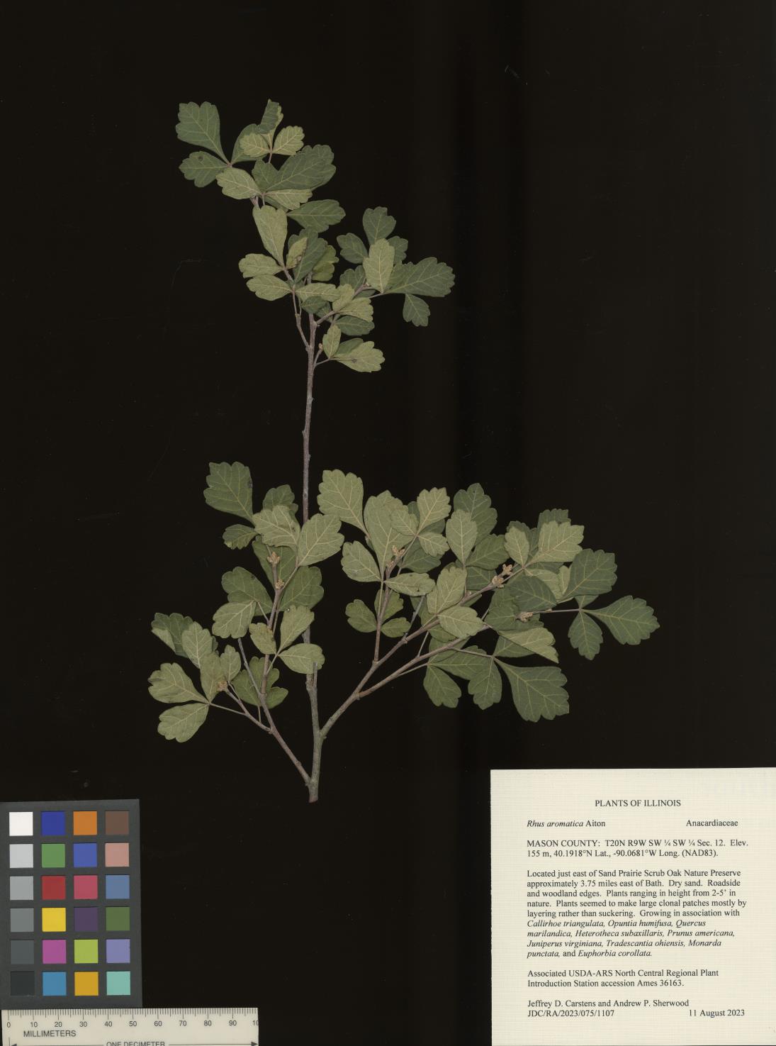 | | 2023 | COLLECTED | 08/11/2023 | Located just east of Sand Prairie Scrub Oak Nature Preserve approximately 3.75 miles east of Bath, T20N R9W SW 1/4 SW 1/4 Sec. 12. | 40.19175000, -90.06813000 | 155 | Dry sand. Roadside and woodland edges. | Wild material | Plants ranging in height from 2-5' in nature. Plants seemed to make large clonal patches mostly by layering rather than suckering. | 2158368 | Ames 36163 |
| 9 | OPGC 8809 | CBG- 10771 | Silene stellata W. T. Aiton | Illinois, United States | OPGC | | | 2023 | | | | | | | Wild material | | 2142239 | OPGC 8809 |
| 10 | OPGC 8829 | CBG- 10834 | Penstemon tubaeflorus Nutt. | Arkansas, United States | OPGC | | | 2023 | | | | | | | Wild material | | 2142283 | OPGC 8829 |
| 11 | W6 61344 | CBG- 10756 | Perideridia americana (Nutt. ex DC.) Rchb. ex Steud. | Illinois, United States | W6 |  | | 2023 | | | | | | | Wild material | | 2142226 | W6 61344 |
| 12 | OPGC 8278 | CBG-9870 | Lobelia spicata Lam. | Wisconsin, United States | OPGC | | | 2021 | | | | | | | Wild material | | 2120028 | OPGC 8278 |
| 13 | OPGC 8308 | CBG-10449 | Krigia biflora (Walter) S. F. Blake | Wisconsin, United States | OPGC | | | 2021 | | | | | | | Wild material | | 2120088 | OPGC 8308 |
| 14 | OPGC 8309 | CBG-10450 | Heuchera richardsonii R. Br. | Wisconsin, United States | OPGC | | | 2021 | | | | | | | Wild material | | 2120089 | OPGC 8309 |
| 15 | OPGC 8343 | CBG-10575 | Euthamia graminifolia (L.) Nutt. | Illinois, United States | OPGC | | | 2021 | | | | | | | Wild material | Plant numbers sampled estimated. | 2120166 | OPGC 8343 |
| 16 | OPGC 8356 | CBG-10606 | Solidago ulmifolia Muhl. ex Willd. | Illinois, United States | OPGC | | | 2021 | | | | | | | Wild material | Plant numbers sampled estimated. | 2120227 | OPGC 8356 |
| 17 | W6 59087 | CBG-9704 | Hymenopappus scabiosaeus LʼHér. | Illinois, United States | W6 | | | 2021 | | | | | | | Wild material | | 2120017 | W6 59087 |
| 18 | W6 59219 | CBG-10524 | Carex brevior (Dewey) Mack. ex Lunell | Illinois, United States | W6 | | | 2021 | | | | | | | Wild material | | 2120135 | W6 59219 |
| 19 | W6 59234 | CBG-10548 | Dasistoma macrophyllum (Nutt.) Raf. | Illinois, United States | W6 | | | 2021 | | | | | | | Wild material | Received as Dasistoma macrophylla. Plant numbers estimated. Few this year; abundant other years in numerous locations. | 2120206 | W6 59234 |
| 20 | W6 59266 | CBG-10588 | Muhlenbergia sobolifera (Muhl. ex Willd.) Trin. | Illinois, United States | W6 | | | 2021 | | | | | | | Wild material | | 2120209 | W6 59266 |
| 21 | W6 60350 | CBG-10730 | Dichanthelium leibergii (Vasey) Freckmann | | W6 |  | | 2021 | | | | | | | Wild material | | 2137982 | W6 60350 |
| 22 | W6 56590 | CBG-8638 | Crocanthemum bicknellii (Fernald) Janch. | Wisconsin, United States | W6 |  | | 2019 | | | | | | | Wild material | | 2092689 | W6 56590 |
| 23 | Ames 34347 | 3240 | Monarda fistulosa L. | Missouri, United States | NC7 |  | | 2018 | COLLECTED | 08/14/2018 | Schwartz Prairie located approximately 4.85 miles southwest of Roscoe near intersection of SW800 and SW 301 Road, T36N R27W SW ¼ SE ¼ Sec. 1 ; St. Clair County | 37.90902900, -93.85101800 | 276 | In dry-mesic, upland prairie remnant. | Wild material | | 1967549 | Ames 34347 |
| 24 | W6 53068 | CBG-6880 | Koeleria macrantha (Ledeb.) Schult. | Wisconsin, United States | W6 |  | | 2017 | | | | | | | Wild material | | 1954819 | W6 53068 |
| 25 | Ames 34038 | Ames 34038 | Monarda punctata L. | Illinois, United States | NC7 |  | | 2017 | COLLECTED | 10/29/2017 | Nachusa Grasslands located approximately 4.17 miles northwest of Franklin Grove just west of Lowden Road, T22N R10E NW 1/4 NW 1/4 SE 1/4 Sec. 16, Ogle County. | 41.89120000, -89.34490000 | 225 | Newly disturbed ground (fenceline installation 2015) consisting of almost level sandy soil with a very slight slope. | Wild material | Plants ranging between 16-22" in height, branched with numerous seed heads. | 1954327 | Ames 34038 |
| 26 | Ames 34014 | Ames 34014 | Aronia melanocarpa (Michx.) Elliott | Illinois, United States | NC7 |  | | 2017 | COLLECTED | 09/03/2017 | Nachusa Grasslands - locally known as Coyote Point approximately 3.80 miles northwest of Franklin Grove just 0.60 miles west of Lowden Road, T22N R10E NE 1/4 NE 1/4 SW 1/4 Sec. 21, Lee County | 41.87972200, -89.35305600 | 220 | St. Peter's sandstone cliff, specimens noted on ridgetop and on slopes. | Wild material | This accession based on morphological/phenological observations at NCRPIS field plots seems to represent the "southern form" of A. melanocarpa, potentially a new Aronia species. This southern form was originally discovered by Brand et al. 2022 (Ploidy, genetic diversity and speciation of the genus Aronia) and is known for having glabrous stems and leaves and a distinct phyllotaxy than other Aronia species. In addition, plants tend to bloom approximately two weeks later than all other Aronia taxonomic groups and the inflorescences/infructescences are more spreading and extended due to longer peduncles and pedicels within the cyme. Fruit maturity tends to occur 2 to 4 weeks later than tetraploid A. melanocarpa and 4 to 6 weeks later than diploid A. melanocarpa. Phenolic levels are much higher in comparison to other A. melanocarpa accessions (Brand et al., 2017 - Anthocyanins, total phenolics, ORAC and moisture content of wild and cultivated dark-fruited Aronia species.) | 1953928 | Ames 34014 |
| 27 | Ames 34701 | CBG-2633 | Drymocallis arguta (Pursh) Rydb. | Wisconsin, United States | NC7 |  | | 2015 | COLLECTED | 09/05/2013 | Lone Rock Prairie located on southwest corner of Mineral Point and Lone Rock Road, T3N R11E Sec. 31. | 42.68560000, -89.23245000 | 264 | Prairie remnant. | Wild material | | 1926087 | Ames 34701 |
| 28 | W6 49522 | CBG-2457 | Carex muehlenbergii Schkuhr ex Willd. | Illinois, United States | W6 |  | | 2015 | | | | | | | Wild material | | 1926154 | W6 49522 |
| 29 | W6 49540 | CBG-2482 | Erigeron strigosus Muhl. ex Willd. | Wisconsin, United States | W6 |  | | 2015 | | | | | | | Wild material | | 1926014 | W6 49540 |
| 30 | W6 49544 | CBG-2486 | Juncus interior Wiegand | Illinois, United States | W6 |  | | 2015 | | | | | | | Wild material | | 1926018 | W6 49544 |
| 31 | W6 49622 | CBG-2635 | Amorpha canescens Pursh | Wisconsin, United States | W6 |  | | 2015 | | | | | | | Wild material | | 1926088 | W6 49622 |
| 32 | W6 49656 | CBG-2686 | Dalea candida Michx. ex Willd. var. candida | Illinois, United States | W6 |  | | 2015 | | | | | | | Wild material | | 1926118 | W6 49656 |