| 0 | PI 341756 | 'Groeneveld' | Ulmus ×hollandica Mill. | Netherlands | NC7 |  | | 1969 | DONATED | 03/20/1969 | | | | | Cultivar | Crown dense and narrow. Twigs gray. Growth slow. Resistance high. | 1254938 | PI 341756 |
| 1 | Ames 35752 | #476-477 | Rhus glabra L. | Iowa, United States | NC7 | 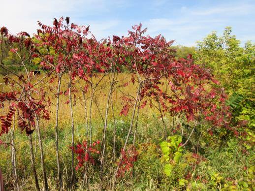 | | 2021 | COLLECTED | 09/29/2021 | Upper Iowa River area near Bluffton, T99N R9W NE1/4 Sec. 9 and S1/2 Sec. 10 | 43.40275000, -91.90494000 | 299 | High bluffs, roadside and stream banks | Wild material | Plants sampled in nature (29 September 2021) during peak fall color displaying bright reds to maroonish colors while measuring approximately 12-15 feet in height. One clonal patch noted was estimated to have 1,000+ ramets. | 2122093 | Ames 35752 |
| 2 | NA 82188 | 27 | Aesculus glabra Willd. | Iowa, United States | NA |  | | 2003 | COLLECTED | 09/22/2003 | Lacey-Keosauqua State Park, Keosauqua, SE corner of SE 1/4 of NE 1/4 and NE 1/4 of SE 1/4 of Section 3, T68N, R10W, Keosauqua Quad, Van Buren County | 40.71777770, -91.98972220 | 177 | Floodplain. Half shaded. Associated with Rhamnus lanceolata, Cercis, Ulmus rubra, Ostrya, and Celtis | Wild material | Medium sized. | 1923816 | NA 82188 |
| 3 | PI 664869 | JDC/HP/2008/030/100 | Hypericum prolificum L. | Missouri, United States | NC7 |  | | 2008 | COLLECTED | 10/06/2008 | Rudolf Bennitt Conservation Area, NE 1/4 of NE 1/4 of Section 25, T52N, R14W, Renick Quad, Randolph County. | 39.27527778, -92.43388889 | 256 | | Wild material | | 1788211 | PI 664869 |
| 4 | PI 495604 | 8 | Cornus drummondii C. A. Mey. | Iowa, United States | NC7 |  | | 1984 | COLLECTED | 09/21/1984 | Along south end of parking area, Lake of Three Fires State Park, extreme NW corner of Section 7, T68N, R33W, Bedford Quad, Taylor County. | 40.71194444, -94.68583333 | 360 | | Wild material | Perennial woody. Plants in wide thicket to 2 meters tall, heavy fruiting. Very clean foliage with nice white fruits. | 1390540 | PI 495604 |
| 5 | NA 89158 | 2025RJLSEUS-06 | Cornus florida L. | Alabama, United States | NA | | | 2025 | COLLECTED | 10/01/2025 | Coosa Wildlife Management Area: along the edge of gated dirt road on the west side of Coosa County Road 29, 0.3 kilometers north of Hatchet Creek. | 32.86402200, -86.33871400 | 108 | Plants are growing in part sun to shade on dry-mesic slopes above the road cut on the gated dirt road; most likely a road for access for fire control/forest management. The forest is a combination of deciduous and evergreen with evergreens primarily comprised of Pinus taeda. The habitat was quite dry during this time of year. Slope: 5 to 20 percent. Aspect: North. Soils: The primary soil in the area of this collection is classified as Madison-Louisa Series complex, 15 to 30 percent slopes, moderately eroded (MdE2). The Madison Series soils are very deep, well drained soils with medium runoff found on Piedmont uplands in interstream divides, ridges and side slopes. They are comprised of residuum weathered from felsic or intermediate, high-grade metamorphic or igneous rocks high in content of mica. Slopes range from 2 to 60 percent and soil is typically strongly acidic. Louisa Series soils The Louisa Series soils consist of shallow, somewhat excessively drained soils which formed over mica gneiss and schist bedrock. They occur on Piedmont uplands. Slopes are 6 to 80 percent. This soil is moderately acid. (Source: California Soil Resource Lab/NRCS Official Soil Series Descriptions). Geology: The underlying geology of this area is of Precambrian to Paleozoic origin and characterized as Hatchet Creek Group; Pinchoulee Gneiss Formation. It is characterized by medium to fine-grained migmatitic, locally garnetiferous biotite-feldspar gneiss, commonly saturated with granitic pods. (Source: USGS Alabama Geologic Map Data). | Wild material | | 2193004 | NA 89158 |
| 6 | NA 89115 | TLM25-04a | Hamamelis ovalis S. W. Leonard | Texas, United States | NA | | | 2025 | COLLECTED | 07/10/2025 | State Highway 87 approximately 3.25 kilometers north of the crossroad junction with Texas Recreational Road 255 (RE 255); plants were growing in the narrow buffer woods along the east side of the highway. | 31.12051300, -93.72628100 | 138 | The habitat is an upland mixed coniferous and deciduous woodlands in part to full shade and dry conditions, often under drought stress. Plants seem to always occur on the top of dry ridges or well-drained slopes. Slope: 0 to 1 percent. Aspect: N/A. Soils: The soils of this collection area are classified as Tehran-Letney Association, hilly (TLE) soils. The Tehran Series (55%) consists of deep, somewhat excessively drained, moderately rapidly permeable soils on uplands. They formed in thick loamy and sandy sediments on the Western Coastal Plain. These soils are on gently sloping to moderately steep uplands with slopes ranging from 1 to 20 percent. The Letney Series (30%) consists of deep, well drained, moderately rapidly permeable, upland soils. They formed in thick sandy and loamy sediments of the coastal plains. These soils are on gently sloping to moderately steep uplands with slopes ranging from 1 to 20 percent. Soil pH ranges from 4.5 to 6.0. The minor soil components include Doucette Series (10%) and Boykin Series (5%) soils. (Source: California Soil Resource Lab/NRCS Official Soil Series Descriptions). Geology: The underlying geology of this area is of Oligocene origin and characterized as Catahoula Formation. This formation is extensive and deep in Texas, up to 185 meters thick. In the area of the collection the Catahoula Formation is primarily mudstone and sand. The upper 90-150 meters is mudstone that is tuffaceous, and sandy; also, occasionally, with some bentonitic clay. (Source: USGS Texas Geologic Map Data). | Wild material | | 2191654 | NA 89115 |
| 7 | NA 89078 | 2024RJLPA-004 | Staphylea trifolia L. | Pennsylvania, United States | NA | | | 2024 | COLLECTED | 09/20/2024 | Along gated road about 0.33 kilometers southwest of the Lake Ontelaunee Trail parking lot. | 40.49850800, -75.89121300 | 94 | Plants are growing on well-drained steep slopes in shade to part shade of a deciduous forest. Slope: 35 to 50 percent. Aspect: East-southeast. Geology: The underlying geology of this area is of Ordovician origin and characterized as Shale and graywacke of Hamburg sequence. It is characterized by shale containing zones of conspicuous graywacke. (Source: USGS Pennsylvania Geologic Map Data). Soils: The primary soil type in the area of this collection is classified as Berks-Weikert Complex, 25 to 60% slopes (BkF). Dominantly sloping to very steep, moderately deep and shallow, well drained soils underlain by acid shale bedrock. (Source: UPenn State University Soil Info Website). EPA Ecoregion (Level III): Ridge and Valley (67). EPA Ecoregion (Level IV): Northern Shale Valleys (67b). | Wild material | | 2169042 | NA 89078 |
| 8 | NA 89081 | 2024RJLPA-009 | Rosa carolina L. | Pennsylvania, United States | NA | | | 2024 | COLLECTED | 09/22/2024 | Lancaster and York Counties: outcrops along the Susquehanna River, accessed from the Historic Lock 12 parking lot off of Pennsylvania Road 372. | 39.81483500, -76.32762200 | 34 | Plants are growing from part-sun to full sun in crevices of the outcrops and where organic debris has accumulated in between boulders along the Susquehanna River. The sites range from nearly xeric to dry mesic, at least on the surface. Plants are generally growing 4-10 m above the normal flow of the river; however, the Holtwood Dam is less than 1 kilometer upstream and debris found trapped in the boulders indicates that there is periodic flooding, at least, in the lower zone of 4+ meters or so above normal river flow. This habitat has a diverse assemblage of deciduous trees and shrubs as well as abundant herbaceous taxa. Slope: 0 to 60 percent. Aspect: Northeast (generally). Geology: The underlying geology of this area is probably of lower Paleozoic age and characterized as the Octoraro Formation. It includes albite-chlorite schist, phyllite, some hornblende gneiss, and granitized members. Soils: The area where this species occurs is right on the edge of two soil zones that transition from the river’s edge to mesic conditions upslope. The first is generally referred to as Rock Outcrop. This terrestrial matrix in which plants grow is largely exposed underlying rock geology with accumulated outwash, rock decomposition, and organic debris buildup. The second is Mt. Airy (80%) and Manor (20%) Series soils, 25 to 60 percent slopes, extremely stony (MRF). (Source: California Soil Resource Lab/NRCS Official Soil Series Descriptions). EPA Ecoregion (Level III): Northern Piedmont (64). EPA Ecoregion (Level IV): Piedmont Uplands (64c). | Wild material | | 2169045 | NA 89081 |
| 9 | NA 89082 | 2024RJLPA-010 | Amorpha fruticosa L. | Pennsylvania, United States | NA | | | 2024 | COLLECTED | 09/22/2024 | Outcrops along the Susquehanna River, accessed from the Historic Lock 12 parking lot off of Pennsylvania Road 372. | 39.81481500, -76.32757900 | 34 | Plants are growing from part-sun to full sun in crevices of the outcrops and where organic debris has accumulated in between boulders along the Susquehanna River. The sites range from nearly xeric to dry mesic, at least on the surface. Plants are generally growing 4-10 m above the normal flow of the river; however, the Holtwood Dam is less than 1 kilometer upstream and debris found trapped in the boulders indicates that there is periodic flooding, at least, in the lower zone of 4+ meters or so above normal river flow. This habitat has a diverse assemblage of deciduous trees and shrubs as well as abundant herbaceous taxa. Slope: 0 to 25 percent. Aspect: Northeast (generally). Geology: The underlying geology of this area is probably of lower Paleozoic age and characterized as the Octoraro Formation. It includes albite-chlorite schist, phyllite, some hornblende gneiss, and granitized members. Soils: The area where this species occurs is right on the edge of two soil zones that transition from the river’s edge to mesic conditions upslope. The first is generally referred to as Rock Outcrop. This terrestrial matrix in which plants grow is largely exposed underlying rock geology with accumulated outwash, rock decomposition, and organic debris buildup. The second is Mt. Airy (80%) and Manor (20%) Series soils, 25 to 60 percent slopes, extremely stony (MRF). (Source: California Soil Resource Lab/NRCS Official Soil Series Descriptions). EPA Ecoregion (Level III): Northern Piedmont (64). EPA Ecoregion (Level IV): Piedmont Uplands (64c). | Wild material | | 2169046 | NA 89082 |
| 10 | NA 89083 | 2024RJLPA-012 | Rhododendron periclymenoides (Michx.) Shinners | Pennsylvania, United States | NA | | | 2024 | COLLECTED | 09/22/2024 | Outcrops along the Susquehanna River, accessed from the Historic Lock 12 parking lot off of Pennsylvania Road 372. | 39.81477400, -76.32807300 | 35 | Plants are growing from shade to part-sun and occasionally full sun in crevices of the outcrops and where organic debris has accumulated in between boulders along the Susquehanna River. The sites range from nearly xeric to mesic, at least on the surface. Plants are generally growing 4-10 m above the normal flow of the river; however, the Holtwood Dam is less than 1 kilometer upstream and debris found trapped in the boulders indicates that there is periodic flooding, at least, in the lower zone of 4+ meters or so above normal river flow. This habitat has a diverse assemblage of deciduous trees and shrubs as well as abundant herbaceous taxa. Slope: 0 to 60 percent. Aspect: Northeast (generally). Geology: The underlying geology of this area is probably of lower Paleozoic age and characterized as the Octoraro Formation. It includes albite-chlorite schist, phyllite, some hornblende gneiss, and granitized members. Soils: The area where this species occurs is right on the edge of two soil zones that transition from the river’s edge to mesic conditions upslope. The first is generally referred to as Rock Outcrop. This terrestrial matrix in which plants grow is largely exposed underlying rock geology with accumulated outwash, rock decomposition, and organic debris buildup. The second is Mt. Airy (80%) and Manor (20%) Series soils, 25 to 60 percent slopes, extremely stony (MRF). (Source: California Soil Resource Lab/NRCS Official Soil Series Descriptions). EPA Ecoregion (Level III): Northern Piedmont (64). EPA Ecoregion (Level IV): Piedmont Uplands (64c). | Wild material | | 2169047 | NA 89083 |
| 11 | NA 89084 | 2024RJLPA-013 | Physocarpus opulifolius (L.) Maxim. | Pennsylvania, United States | NA | | | 2024 | COLLECTED | 09/22/2024 | Outcrops along the Susquehanna River, accessed from the Historic Lock 12 parking lot off of Pennsylvania Road 372. | 39.81466300, -76.32833900 | 36 | Plants are growing from shade to part-sun where organic debris has accumulated in between boulders as well as further upslope in deeper mesic soils along the Susquehanna River. This habitat has a diverse assemblage of deciduous trees and shrubs as well as abundant herbaceous taxa. Slope: 10 to 25 percent. Aspect: Northeast (generally). Geology: The underlying geology of this area is probably of lower Paleozoic age and characterized as the Octoraro Formation. It includes albite-chlorite schist, phyllite, some hornblende gneiss, and granitized members. Soils: The area where this species occurs is right on the edge of two soil zones that transition from the river’s edge to mesic conditions upslope. The first is generally referred to as Rock Outcrop. This terrestrial matrix in which plants grow is largely exposed underlying rock geology with accumulated outwash, rock decomposition, and organic debris buildup. The second is Mt. Airy (80%) and Manor (20%) Series soils, 25 to 60 percent slopes, extremely stony (MRF). (Source: California Soil Resource Lab/NRCS Official Soil Series Descriptions). EPA Ecoregion (Level III): Northern Piedmont (64). EPA Ecoregion (Level IV): Piedmont Uplands (64c). | Wild material | | 2169048 | NA 89084 |
| 12 | NA 89085 | 2024RJLPA-014 | Rhododendron arborescens (Pursh) Torr. | Pennsylvania, United States | NA | | | 2024 | COLLECTED | 09/22/2024 | Outcrops along the Susquehanna River, accessed from the Historic Lock 12 parking lot off of Pennsylvania Road 372. | 39.81618100, -76.33069800 | 38 | Plants are growing from shade to part-sun and occasionally full sun in crevices of the outcrops and where organic debris has accumulated in between boulders along the Susquehanna River. The sites range from nearly xeric to mesic, at least on the surface. Plants are generally growing 4-10 m above the normal flow of the river; however, the Holtwood Dam is less than 1 kilometer upstream and debris found trapped in the boulders indicates that there is periodic flooding, at least, in the lower zone of 4+ meters or so above normal river flow. This habitat has a diverse assemblage of deciduous trees and shrubs as well as abundant herbaceous taxa. Slope: 0 to 75 percent. Aspect: Northeast (generally). Geology: The underlying geology of this area is probably of lower Paleozoic age and characterized as the Octoraro Formation. It includes albite-chlorite schist, phyllite, some hornblende gneiss, and granitized members. Soils: The area where this species occurs is right on the edge of two soil zones that transition from the river’s edge to mesic conditions upslope. The first is generally referred to as Rock Outcrop. This terrestrial matrix in which plants grow is largely exposed underlying rock geology with accumulated outwash, rock decomposition, and organic debris buildup. The second is Mt. Airy (80%) and Manor (20%) Series soils, 25 to 60 percent slopes, extremely stony (MRF). (Source: California Soil Resource Lab/NRCS Official Soil Series Descriptions). EPA Ecoregion (Level III): Northern Piedmont (64). EPA Ecoregion (Level IV): Piedmont Uplands (64c). | Wild material | | 2169049 | NA 89085 |
| 13 | NA 89086 | 2024RJLPA-015 | Ilex verticillata (L.) A. Gray | Pennsylvania, United States | NA | | | 2024 | COLLECTED | 09/22/2024 | Outcrops along the Susquehanna River, accessed from the Historic Lock 12 parking lot off of Pennsylvania Road 372. | 39.81656600, -76.33136600 | 38 | Plants are growing from part-sun to full sun in crevices of the outcrops and where organic debris has accumulated in between boulders along the Susquehanna River. The sites range from nearly xeric to dry mesic, at least on the surface. Plants are generally growing 4-10 m above the normal flow of the river; however, the Holtwood Dam is less than 1 kilometer upstream and debris found trapped in the boulders indicates that there is periodic flooding, at least, in the lower zone of 4+ meters or so above normal river flow. This habitat has a diverse assemblage of deciduous trees and shrubs as well as abundant herbaceous taxa. Slope: 0 to 10 percent. Aspect: Northeast (generally). Geology: The underlying geology of this area is probably of lower Paleozoic age and characterized as the Octoraro Formation. It includes albite-chlorite schist, phyllite, some hornblende gneiss, and granitized members. Soils: The area where this species occurs is right on the edge of two soil zones that transition from the river’s edge to mesic conditions upslope. The first is generally referred to as Rock Outcrop. This terrestrial matrix in which plants grow is largely exposed underlying rock geology with accumulated outwash, rock decomposition, and organic debris buildup. The second is Mt. Airy (80%) and Manor (20%) Series soils, 25 to 60 percent slopes, extremely stony (MRF). (Source: California Soil Resource Lab/NRCS Official Soil Series Descriptions). EPA Ecoregion (Level III): Northern Piedmont (64). EPA Ecoregion (Level IV): Piedmont Uplands (64c). | Wild material | | 2169050 | NA 89086 |
| 14 | NA 89087 | 2024RJLPA-016 | Hydrangea arborescens L. | Pennsylvania, United States | NA | | | 2024 | COLLECTED | 09/22/2024 | Outcrops along the Susquehanna River, accessed from the Historic Lock 12 parking lot off of Pennsylvania Road 372. | 39.81489000, -76.32912200 | 43 | Plants are growing in deep shade of the deciduous woodlands on outcrops and the steep slopes where organic debris and detritus has accumulated. This habitat has a diverse assemblage of deciduous trees and shrubs as well as abundant herbaceous taxa. Slope: 30 to 90 percent. Aspect: Northeast (generally). Geology: The underlying geology of this area is probably of lower Paleozoic age and characterized as the Octoraro Formation. It includes albite-chlorite schist, phyllite, some hornblende gneiss, and granitized members. (Source: Source: USGS Pennsylvania Geologic Map Data). Soils: The area where this species occurs is right on the edge of two soil zones that transition from the river’s edge to mesic conditions upslope. The first is generally referred to as Rock Outcrop. This terrestrial matrix in which plants grow is largely exposed underlying rock geology with accumulated outwash, rock decomposition, and organic debris buildup. The second is Mt. Airy (80%) and Manor (20%) Series soils, 25 to 60 percent slopes, extremely stony (MRF). (Source: California Soil Resource Lab/NRCS Official Soil Series Descriptions). EPA Ecoregion (Level III): Northern Piedmont (64). EPA Ecoregion (Level IV): Piedmont Uplands (64c). | Wild material | | 2169051 | NA 89087 |
| 15 | NA 87823 | FL24-01 | Ilex cassine L. | Florida, United States | NA | | | 2024 | COLLECTED | 09/05/2024 | Matanzas State Forest. | 29.72143991, -81.28386478 | | Boggy blackwater ditches along edge of dirt road. EPA Ecoregion III: Southern Coastal Plain (75). EPA Ecoregion IV: Eastern Florida Flatwoods (75d). Geology: Beach Ridge and Dune. Soil: Immokalee Series Fine Sand. | Wild material | | 2168973 | NA 87823 |
| 16 | NA 88820 | TJK2023AL-005 | Hydrangea arborescens L. | Alabama, United States | NA | | | 2023 | COLLECTED | 12/07/2023 | Between Monroe County Route 1 and Tom Hayles Road. | 31.40575900, -87.54924000 | 22 | In woodlands on limestone outcrop. While the upper area of slopes is covered by a thin soil layer, the exposed limestone rock outcrop on the northwestern edge of this area is a low competition niche for plants like the Hydrangea to gain a foothold. Slope: 60% (plus). Aspect: Northwest. Elevation: 72 feet. | Wild material | | 2165649 | NA 88820 |
| 17 | NA 88821 | TJK2023AL-006 | Hydrangea quercifolia W. Bartram | Alabama, United States | NA | | | 2023 | COLLECTED | 12/07/2023 | Between Monroe County Route 1 and Tom Hayles Road. | 31.40580000, -87.54890000 | 22 | In woodlands on limestone outcrop. While the upper area of slopes is covered by a thin soil layer, the exposed limestone rock outcrop on the northwestern edge of this area is a low competition niche for plants like the Hydrangea to gain a foothold. Slope: 60% (plus). Aspect: Northwest. Elevation: 72 feet. | Wild material | | 2165650 | NA 88821 |
| 18 | NA 88676 | RJL2023PA-010 | Staphylea trifolia L. | Pennsylvania, United States | NA | | | 2023 | COLLECTED | 10/25/2023 | Seed collected along the Appalachian National Scenic Trail, accessed from the Duncannon Entrance. | 40.38132600, -77.02965700 | 103 | Well-drained and very rocky deciduous woodlands where soil has accumulated in part shade to full shade. Slope: 0-30%. Aspect: variable. The underlying geology of this area is of Devonian origin and characterized as the Duncannon Member of Catskill Formation. It is characterized by grayish-red sandstone, siltstone, and mudstone in fining-upward cycles; conglomerate occurs at base of some cycles. The sandstones which comprise the Duncannon Member are fine to very coarse grained and grayish red to grayish red-purple in color. The Duncannon Member is known to be crossbedded to planar bedded in beds anywhere from 3 to 9 meters thick. Conglomerates have been spotted at the base of the Duncannon Member. The Duncannon Member is poorly exposed in most areas except along the Lehigh River. The conglomerate portion of this member has been known to form ridges and ledges with thicknesses approaching 228 meters. (Source: USGS Pennsylvania Geologic Map Data). The primary soil type in the collection area is classified as Hazleton Series. The Hazleton series consists of deep and very deep, well drained soils formed in residuum of acid gray, brown or red sandstone on uplands. Slope ranges from 0 to 80 percent. Permeability is moderately rapid to rapid. Solum thickness ranges from 60 to 120 centimeters. Depth to lithic contact ranges from 1 to 2 meters. Rock fragments of angular sandstone, dominantly less than 25 cm in size, range from 5 to 70 percent in individual horizons. Boulders, stones, flags and channers cover about 5 to 60 percent of the surface of some pedons. Reaction ranges from strongly acid through extremely acid throughout. (Source: NRCS Web Soil Survey). | Wild material | | 2159067 | NA 88676 |
| 19 | NA 89233 | UK Arb. 2023-0059-A | Cladrastis kentukea (Dum. Cours.) Rudd | Kentucky, United States | NA | | | 2023 | COLLECTED | 08/22/2023 | Blue Sportsmen's League (land owner): trees growing on both sides of eroded dirt road from campground to Kentucky River. | 37.78777000, -84.65356000 | | Calcareous rocky woods, mid-slope. Slope: 20-30%. Aspect: Southwest. | Wild material | | 2158476 | NA 89233 |
| 20 | NA 89235 | UK Arb. 2023-0061-A | Cladrastis kentukea (Dum. Cours.) Rudd | Kentucky, United States | NA | | | 2023 | COLLECTED | 08/22/2023 | Tom Dorman State Nature Preserve: trees growing adjacent to west side of loop trail going down towards Kentucky River. | 37.77180000, -84.63011000 | | Calcareous, rocky woods, mid-slope down towards river. | Wild material | | 2158478 | NA 89235 |
| 21 | Ames 36016 | Sugar Creek | Platanus occidentalis L. | Iowa, United States | NC7 |  | | 2023 | COLLECTED | 02/20/2023 | Scattered along Sugar Creek between 3.1 miles north and also 1.3 miles northeast of Franklin, T68N R6W Sections 2, 11, 12, 13 and 24. | 40.70277500, -91.51065900 | 185 | River banks and floodplains. | Wild material | This accession of American sycamore includes the sampling from several very large specimens found in the state of Iowa including specimen #211-12 currently (2023) ranking 13th largest measuring 14' 9" circumference; 106' 8" in height; and a calculated spread of 114' 8" totalling 312.346 points (measured 23 April 2023 by Mark Rouw); specimen #211-10 currently (2023) ranking as the 9th largest measuring 16' 2" circumference; 97' 5" in height; and a calculated spread of 134' 3" totalling 322.983 points (measured 21 April 2020 by Mark Rouw); and specimen #211-6 currently (2023) ranking 2nd largest measuring 20' 2.5" circumference; 109' 6" in height; and a calculated spread of 148' 9" totalling 389.188 points (measured 23 April 2023 by Mark Rouw). Numerous specimens noted in nature with extremely white, superior, ornamental bark characteristics, specifically specimen #211-13. | 2141476 | Ames 36016 |
| 22 | NA 88549 | RJLSEUS2022-022 | Rhododendron minus Michx. var. minus | Georgia, United States | NA | | | 2023 | COLLECTED | 12/10/2022 | East side of Georgia State Hwy. 39, on the south side of Kolomoki Creek approximately 11 kilometers south of Fort Gaines, Georgia. Common on this site, but otherwise infrequent. This species is near the southernmost end of its natural range. | 31.52053400, -85.02351600 | 53 | Plants are growing in part-shade to shade of deciduous upland, dry, deciduous woodlands on steep slopes 10-15 meters above Kolomoki Creek.
Soils: The underlying geology of this area is of Paleocene origin and characterized as Tuscahoma Sand. As mapped this formation includes lower Eocene Bashi Marl Member of the Hatchetigbee Formation. This formation consists of light-gray to light-olive-gray laminated and thin-bedded carbonaceous silt and clay interbedded with fine sand; thin lignite beds occur locally. Lower part of the formation includes beds of fossiliferous, glauconitic fine quartz sand containing spheroidal sandstone concretions, gravel and clay pebbles.
Source: USGS Georgia Geologic Map Data (https://mrdata.usgs.gov/geology/state/sgmc-unit.php?unit=GANu%3B1)
The primary soil types in the collection area are classified as Ailey-Cowarts Complex Series soils (8 to 25 percent slopes). The Ailey Series consists of well drained or somewhat excessively drained soils formed by fluviomarine and marine deposits. These soils are found marine terraces and low hills of the upper coastal plain and sandhills; they are strongly acidic. The Cowarts Series consists of very deep, moderately well and well drained soils on ridge tops and side slopes on uplands of the Coastal Plain Major Land Resource Area. They formed in loamy marine sediments. Slopes range from 1 to 60 percent.
Source: NRCS Web Soil Survey (https://websoilsurvey.sc.egov.usda.gov/App/WebSoilSurvey.aspx) | Wild material | | 2140776 | NA 88549 |
| 23 | NA 88550 | RJLSEUS2022-023 | Kalmia latifolia L. | Georgia, United States | NA | | | 2023 | COLLECTED | 12/10/2022 | East side of Georgia State Hwy. 39, on the south side of Kolomoki Creek approximately 11 kilometers south of Fort Gaines, Georgia. Common on this site, but otherwise infrequent. This species is near the southernmost end of its natural range. | 31.52053400, -85.02351600 | 53 | Plants are growing in part-shade to shade of deciduous upland, dry, deciduous woodlands on steep slopes 10-15 meters above Kolomoki Creek.
Soils: The underlying geology of this area is of Paleocene origin and characterized as Tuscahoma Sand. As mapped this formation includes lower Eocene Bashi Marl Member of the Hatchetigbee Formation. This formation consists of light-gray to light-olive-gray laminated and thin-bedded carbonaceous silt and clay interbedded with fine sand; thin lignite beds occur locally. Lower part of the formation includes beds of fossiliferous, glauconitic fine quartz sand containing spheroidal sandstone concretions, gravel and clay pebbles.
Source: USGS Georgia Geologic Map Data (https://mrdata.usgs.gov/geology/state/sgmc-unit.php?unit=GANu%3B1)
The primary soil types in the collection area are classified as Ailey-Cowarts Complex Series soils (8 to 25 percent slopes). The Ailey Series consists of well drained or somewhat excessively drained soils formed by fluviomarine and marine deposits. These soils are found marine terraces and low hills of the upper coastal plain and sandhills; they are strongly acidic. The Cowarts Series consists of very deep, moderately well and well drained soils on ridge tops and side slopes on uplands of the Coastal Plain Major Land Resource Area. They formed in loamy marine sediments. Slopes range from 1 to 60 percent.
Source: NRCS Web Soil Survey (https://websoilsurvey.sc.egov.usda.gov/App/WebSoilSurvey.aspx) | Wild material | | 2140777 | NA 88550 |
| 24 | WLP 2670 | RJL2022PA-016 | Acer negundo L. | Pennsylvania, United States | NA | | | 2022 | COLLECTED | 10/21/2022 | Plants growing in woodlands above a small unnamed creek that dumps into the Middle Branch White Clay Creek in Goddard Park, West Grove Pennsylvania, off of Wickerton Road, Chester County. Plants are found regularly but scattered in the understory of the woodlands. | 39.80426000, -75.82609300 | 105 | Plants growing in a mesic, well-drained habitat of deciduous woodlands along streams and above the riparian zone that drains toward a small unnamed creek that feeds into the Middle Branch White Clay Creek. Plants generally grow in part shade to full sun, but perform best and fruit more heavily in full sun where there is abundant access to moisture. The remnant woodlands exist mostly along the steep slopes, wetlands and seeps of seasonal and year-round creeks flowing into the Middle Branch White Clay Creek. The woodlands are bordered by numerous housing developments and land converted to meadows; hence there is significant first order edge that is heavily impacted by invasive plant intrusion. Despite this fact, Acer negundo is highly competitive and competes well.
Soils: The underlying geology of this area is the Glenarm Wissahickon Formation of lower Paleozoic origin and lithologically similar to oligoclase-mica schist of the Wissahickon Formation (PZw), but also includes lenticular amphibolite bodies having ocean-floor basalt chemistry.
Source: USGS Pennsylvania Geologic Map Data (https://mrdata.usgs.gov/geology/state/sgmc-unit.php?unit=PAPZgw%3B0)
The primary soil type in the area of this collection is classified as Glenelg silt loam, 3 to 8 percent slopes. This series consists of very deep, well drained soils formed in residuum weathered from micaceous schist on uplands of the Blue Ridge and the Northern Piedmont. Saturated hydraulic conductivity is moderately high in the subsoil and moderately high to high in the substratum. This upper horizon of this soil is undifferentiated, mostly poorly drained sandy bottomland soils intermingled with decomposing organic litter and eroded silts and clays due to erosion.
Source: NRCS Web Soil Survey (https://websoilsurvey.sc.egov.usda.gov/App/WebSoilSurvey.aspx) | Wild material | | 2139661 | WLP 2670 |
| 25 | NA 89039 | RJL2022IL-001 | Ptelea trifoliata L. | Illinois, United States | NA | | | 2022 | COLLECTED | 09/28/2022 | Site of plant habitat is located at 823 E Co Rd 1220, Hamilton, IL 62341 which is the property where Jacob's Geode Shop and Mine is located. This species is scattered and relatively common throughout the woodlands on this site. | 40.37848400, -91.35390200 | 175 | Plants growing in shade to part-shade of deciduous woodlands above a small creek.
Soils: The underlying geology of this area is of Mississippian origin and comprised of Warsaw Formation and Salem Limestone. Major lithological components include limestone that can be shaly, oolitic, bioclastic, or cherty. Minor lithological components include siltstone that can contain geodes or drusy quartz and can be calcareous.
Source: USGS Illinois Geologic Map Data (https://mrdata.usgs.gov/geology/state/sgmc-unit.php?unit=ILMws%3B0)
The surface soil profile of this area is Coffeen silt loam, 0 to 2 percent slopes, that are frequently flooded. The Coffeen series consists of very deep, somewhat poorly drained, moderately permeable soils on flood plains, low terraces or benches, toe slopes, and alluvial fans. They formed in silty alluvium. Much of the alluvium is of local origin derived from the nearby loess-covered uplands.
Source: NRCS Web Soil Survey (https://websoilsurvey.sc.egov.usda.gov/App/WebSoilSurvey.aspx) | Wild material | | 2139604 | NA 89039 |
| 26 | NA 89033 | RJL2022MD-010 | Clethra alnifolia L. | Maryland, United States | NA | | | 2022 | COLLECTED | 09/15/2022 | Plants growing in low woodlands at the end of Greenway Avenue near a boat dock that leads to the Pocomoke River, adjacent to Winter Quarters Golf Course, Pocomoke City. Plants common throughout the wetland area as well as mesic edges of the woodlands. | 38.08305100, -75.56527800 | | Plants growing in the flood plain of the Pocomoke River in shade to part sun of a mixed deciduous and evergreen bottomland habitat about 10 meters from the edge of the golf course fairway. The habitat is a mucky swamp edge habitat next to the Pocomoke River, most of which seems wet year-round and grades slightly upslope to more mesic conditions.
The underlying geology of this area is comprised of Quaternary Deposits of Wisconsin to Holocene origin. The composition is primarily undifferentiated gray to buff sand and gravel, gray to brown lignitic silt and clay, occasional boulders, and rare shell beds. Surficial deposits occur as shell-bearing estuarine clays and silts.
Source: USGS Maryland Geologic Map Data https://mrdata.usgs.gov/geology/state/sgmc-unit.php?unit=MDQdu%3B5
The surface soil profile of this habitat is classified as Puckum Muck which is frequently flooded. These highly saturated soils are found in flats, depressions and swales. The soil reaction of Puckum Muck is extremely acid to strongly acid throughout the profile. The depth to bedrock is generally greater than 150 cm. Wood fragments comprise 0-25%, by volume of the Puckum Muck throughout the profile which includes mostly twigs, branches, logs, or stumps and are 1.5-30 cm in diameter. The composition of these highly saturated soils, are classified as muck (sapric soil material) or mucky peat (hemic soil material) throughout most of the upper 150 cm and may contain thin layers of mucky silt loam, silty clay loam, sandy loam and/or sand.
Source: NRCS Web Soil Survey (https://websoilsurvey.sc.egov.usda.gov/App/WebSoilSurvey.aspx) | Wild material | | 2139598 | NA 89033 |
| 27 | NA 89032 | RJL2022MD-009 | Rhododendron viscosum (L.) Torr. | Maryland, United States | NA | | | 2022 | COLLECTED | 09/15/2022 | Plants growing in low woodlands at the end of Greenway Avenue near a boat dock that leads to the Pocomoke River, adjacent to Winter Quarters Golf Course, Pocomoke City. Plants scattered throughout the wetland area. Infrequent, but regularly found. | 38.08235200, -75.56566500 | 1 | Plants growing in the flood plain of the Pocomoke River in part shade to shade of a mixed deciduous and evergreen bottomland habitat about 10 meters from the edge of the golf course fairway. The habitat is a mucky swamp edge habitat next to the Pocomoke River, most of which seems wet year-round.
The underlying geology of this area is comprised of Quaternary Deposits of Wisconsin to Holocene origin. The composition is primarily undifferentiated gray to buff sand and gravel, gray to brown lignitic silt and clay, occasional boulders, and rare shell beds. Surficial deposits occur as shell-bearing estuarine clays and silts.
Source: USGS Maryland Geologic Map Data https://mrdata.usgs.gov/geology/state/sgmc-unit.php?unit=MDQdu%3B5
The surface soil profile of this habitat is classified as Puckum Muck which is frequently flooded. These highly saturated soils are found in flats, depressions and swales. The soil reaction of Puckum Muck is extremely acid to strongly acid throughout the profile. The depth to bedrock is generally greater than 150 cm. Wood fragments comprise 0-25%, by volume of the Puckum Muck throughout the profile which includes mostly twigs, branches, logs, or stumps and are 1.5-30 cm in diameter. The composition of these highly saturated soils, are classified as muck (sapric soil material) or mucky peat (hemic soil material) throughout most of the upper 150 cm and may contain thin layers of mucky silt loam, silty clay loam, sandy loam and/or sand.
Source: NRCS Web Soil Survey (https://websoilsurvey.sc.egov.usda.gov/App/WebSoilSurvey.aspx) | Wild material | | 2139597 | NA 89032 |
| 28 | WLP 2614 | 2022VA-05 | Euonymus americanus L. | Virginia, United States | NA | | | 2022 | COLLECTED | 09/12/2022 | In Colonial Williamsburg, park in the Providence Hall Directors Wing parking lot and enter the Bassett Trace Nature Trail; this species is found in the woodlands on either side of the trail and over a bridge until the it turns right. This plant is infrequent, but occasionally found in the mesic woodlands throughout this location. | 37.26681600, -76.69252800 | 21 | Plants growing in shade to part-shade of the mixed deciduous and evergreen mesic woodland. This species is generally growing in areas with an abundant organic, mature woodland that is relatively undisturbed.
The underlying geology of this area is Windsor Formation of Tertiary-Quaternary origin (lower Pleistocene or upper Pliocene). It is comprised of gray and yellowish- to reddish-brown sand, gravel, silt, and clay. It constitutes surficial deposits of extensive plain and fluvial-estuarine terraces above elevations of 10 meters. The thickness of the Windsor Formation is 0 to 12.5 meters.
Source: USGS Virginia Geologic Map Data (https://mrdata.usgs.gov/geology/state/sgmc-unit.php?unit=VAQTw%3B0)
The surface soil profile of this area is Emporia Complex, 15 to 25 percent slopes. This soil as moderately well-drained, acidic, and found on sloping and elevated terraces. They are comprised of fine sandy loam, loam, and sandy clay loam in varying quantities across the profile; the depth to parent geology is approximately 200 cm.
Source: NRCS Web Soil Survey (https://websoilsurvey.sc.egov.usda.gov/App/WebSoilSurvey.aspx) | Wild material | | 2139352 | WLP 2614 |
| 29 | NA 86885 | RJL2021PA-004 | Ilex verticillata (L.) A. Gray | Pennsylvania, United States | NA | | | 2021 | COLLECTED | 11/16/2021 | Plants growing in woodlands along a small unnamed creek corridor dumping into the Middle Branch White Clay Creek in Goddard Park, West Grove Pennsylvania, off of Wickerton Road, Chester County. | 39.81063861, -75.82750806 | 124 | Plants are growing in a range of habitats from mesic woodlands to saturated streamside settings of deciduous woodlands that drain toward the Middle Branch White Clay Creek. Plants grow in high understory shade with dappled to indirect sunlight. The only female (fruiting) plants were found in areas along the creek where soils are moist to saturated. Numerous male specimens were found in the areas described above. Soils: Soils found in the areas where this collection was made are comprised primarily of Baile silt loam (Ba), Hatboro silt loam (Ha), and Glenelg silt loam, 8 to 15 percent slopes (GgC). Baile silt loam consists of very deep, poorly drained, moderately low to moderately high saturated hydraulic conductivity, soils on upland depressions and footslopes that were formed in local alluvium over residuum from acid crystalline rocks, chiefly mica schist and granitized schist and gneiss; slope ranges from 0 to 8 percent. Hatboro silt loam consists of very deep and poorly drained soils formed in deposited alluvium derived from metamorphic and crystalline rock. They are on flood plains. Slopes range from 0 to 3 percent. Glenelg silt loam, 8 to 15 percent slopes consists of very deep, well drained soils formed in residuum weathered from micaceous schist on uplands of the Blue Ridge and the Northern Piedmont. This soil is undifferentiated, mostly poorly drained sandy bottomland soils intermingled with decomposing organic litter and eroded silts and clays due to erosion. Slope: 0 to 15% Aspect: Variable. | Wild material | | 2123125 | NA 86885 |
| 30 | WLP 1731 | RJL2021PA-001 | Viburnum acerifolium L. | Pennsylvania, United States | NA | | | 2021 | COLLECTED | 11/05/2021 | Plants growing in woodlands above a small unnamed creek that dumps into the Middle Branch White Clay Creek in Goddard Park, West Grove Pennsylvania, off of Wickerton Road, Chester County. | 39.80462083, -75.82888750 | 103 | Plants growing in a mesic, well-drained habitat of deciduous woodlands, for the most part, above the riparian zone that drains toward a small unnamed creek that feeds into the Middle Branch White Clay Creek. Plants are growing in high understory shade with very little direct sun during most of the day. The remnant woodlands exist mostly along the steep slopes, wetlands and seeps of seasonal and year-round creeks flowing into the Middle Branch White Clay Creek. The woodlands are bordered by numerous housing developments and land converted to meadows; hence there is significant first order edge that is heavily impacted by invasive plant intrusion. Soils: Soils are classified as Glenelg silt loam, 8 to 15% slopes (GgC); this series consists of very deep, well drained soils formed in residuum weathered from micaceous schist on uplands of the Blue Ridge and the Northern Piedmont. Saturated hydraulic conductivity is moderately high in the subsoil and moderately high to high in the substratum. This upper horizon of this soil is undifferentiated, mostly poorly drained sandy bottomland soils intermingled with decomposing organic litter and eroded silts and clays due to erosion. Slope: 8 to 15% Aspect: West. | Wild material | | 2123080 | WLP 1731 |
| 31 | WLP 1732 | RJL2021PA-002 | Viburnum prunifolium L. | Pennsylvania, United States | NA | | | 2021 | COLLECTED | 11/05/2021 | Plants growing in woodlands along a small unnamed creek corridor dumping into the Middle Branch White Clay Creek in Goddard Park, West Grove Pennsylvania, off of Wickerton Road, Chester County. | 39.80462083, -75.82888750 | 102 | Plants are growing in a range of habitats from drier upland woods to moist creekside settings of deciduous woodlands that drain toward the Middle Branch White Clay Creek. Plants grow in part shade to high understory shade with dappled to indirect direct sunlight. Plants achieve their largest size and fruiting potential in part sun of the riparian zone of the creek where woodland canopy is thinner. Soils: Soils found in the areas where this collection was made are comprised primarily of flood plain Hatboro silt loam (Ha) and well-drained, upland Glenelg silt loam, 8 to 15 percent slopes (GgC). Hatboro silt loam consists of very deep and poorly drained soils formed in deposited alluvium derived from metamorphic and crystalline rock. They are on flood plains. Slopes range from 0 to 3 percent. Glenelg silt loam, 8 to 15 percent slopes consists of very deep, well drained soils formed in residuum weathered from micaceous schist on uplands of the Blue Ridge and the Northern Piedmont. This soil is undifferentiated, mostly poorly drained sandy bottomland soils intermingled with decomposing organic litter and eroded silts and clays due to erosion. Slope: 0 to 15% Aspect: Variable. | Wild material | | 2123098 | WLP 1732 |
| 32 | WLP 1733 | RJL2021PA-003 | Viburnum dentatum L. | Pennsylvania, United States | NA | | | 2021 | COLLECTED | 11/05/2021 | Plants growing in woodlands along a small unnamed creek corridor dumping into the Middle Branch White Clay Creek in Goddard Park, West Grove Pennsylvania, off of Wickerton Road, Chester County. | 39.80522167, -75.82928139 | 107 | Plants are growing in a range of habitats from mesic woodland to moist creekside settings of deciduous woodlands that drain toward the Middle Branch White Clay Creek. Plants grow in high understory shade with dappled to indirect sunlight. Soils: Soils found in the areas where this collection was made are comprised primarily of flood plain Hatboro silt loam (Ha) and well-drained, upland Glenelg silt loam, 8 to 15 percent slopes (GgC). Hatboro silt loam consists of very deep and poorly drained soils formed in deposited alluvium derived from metamorphic and crystalline rock. They are on flood plains. Slopes range from 0 to 3 percent. Glenelg silt loam, 8 to 15 percent slopes consists of very deep, well drained soils formed in residuum weathered from micaceous schist on uplands of the Blue Ridge and the Northern Piedmont. This soil is undifferentiated, mostly poorly drained sandy bottomland soils intermingled with decomposing organic litter and eroded silts and clays due to erosion. Slope: 0 to 15% Aspect: Variable. | Wild material | | 2123124 | WLP 1733 |
| 33 | Ames 35746 | Guye Woods | Acer saccharum Marshall subsp. nigrum (F. Michx.) Desmarais | Iowa, United States | NC7 |  | | 2021 | COLLECTED | 09/08/2021 | Guye Woods County Park located 6.0 miles northeast of Winterset, T76N R27W NE1/4 Sec. 4 | 41.41235000, -93.96373000 | 278 | Moist deciduous maple, oak, hickory forest, northwest facing slope above the North River. | Wild material | Multiple specimens in this population were observed to be 24" diameter at breast height (DBH) or larger with the largest specimen encountered at the time of collection measuring 36.5" DBH.
Morphological traits of leaves suggests sampled specimens are true to type of Acer saccharum subsp. nigrum including leaves with three distinct points, leathery/thick, and drooping in appearance. On September 25, 2020 (Schmitz, A., personal communication, 31 January 2022), peak fall color on Acer saccharum subsp. nigrum at Guye Woods was observed with specimens having a clean yellow fall color, also indicative of Acer saccharum subsp. nigrum.
| 2122010 | Ames 35746 |
| 34 | NA 85021 | JDC/SS/2018/004/817 | Sapindus saponaria L. var. drummondii (Hook. & Arn.) L. D. Benson | Oklahoma, United States | NA |  | | 2018 | COLLECTED | 03/12/2018 | Private property approximately 4.8 miles southeast of Mulhall, north side of Cimarron River, T18N R2W, Logan County | 35.99972000, -97.39735900 | 210 | Transition zone between higher elevations and bottomlands. | Wild material | | 1957958 | NA 85021 |
| 35 | NA 85022 | JDC/SS/2018/008/821 | Sapindus saponaria L. var. drummondii (Hook. & Arn.) L. D. Benson | Oklahoma, United States | NA |  | | 2018 | COLLECTED | 03/13/2018 | Thurmond Ranch approximately 3.80 miles southwest of Cheyenne, T13N R24W, Roger Mills County | 35.59226100, -99.69600600 | 554 | Bottomlands and immediate higher elevations of Sergeant Major Creek and surrounding tributaries. | Wild material | | 1957959 | NA 85022 |
| 36 | NA 85024 | JDC/SS/2018/020/833 | Sapindus saponaria L. var. drummondii (Hook. & Arn.) L. D. Benson | Kansas, United States | NA |  | | 2018 | COLLECTED | 03/15/2018 | Private property approximately 3.65 miles north of Lake City on Cottonwood Creek and Sand Creek watersheds, T30S R14W, Barber County | 37.39995200, -98.84153900 | 593 | Cedar and elm woods. | Wild material | | 1957961 | NA 85024 |
| 37 | Ames 33918 | APS/GD/2017/008/267 | Gymnocladus dioicus (L.) K. Koch | Minnesota, United States | NC7 |  | | 2017 | COLLECTED | 03/16/2017 | Minnesota River watershed covering approximately 9.0 river miles between Redwood Falls and Vicksburg Park, Renville County | 44.61447700, -95.14878600 | 254 | Mixed habitats, both upland dry sites, wet sites, and rocky sites. | Wild material | | 1946985 | Ames 33918 |
| 38 | Ames 33229 | JDC/SO/2016/001/716 | Symphoricarpos orbiculatus Moench | Missouri, United States | NC7 | | | 2016 | COLLECTED | 01/13/2016 | Access road near Scobee Lake, NE 1/4 of NE 1/4 of Section 32, T64N R16W, approximately 10.5 miles northwest of Kirksville, Adair County. | 40.30655000, -92.71615200 | | | Wild material | Plants approximately 4 feet in height. Fruits red in color. Variation noted in fruits ranging from bright red to dark red in color. | 1936479 | Ames 33229 |
| 39 | Ames 32223 | APS/GD/2014/002/133 | Gymnocladus dioicus (L.) K. Koch | Illinois, United States | NC7 | | | 2014 | COLLECTED | 03/20/2014 | Vermilion River watershed, N 1/2 of Section 11, T21N, R13W, just southeast of Potomac, Vermilion County. | 40.29257800, -87.78582500 | 202 | Floodplain. | Wild material | | 1917827 | Ames 32223 |
| 40 | Ames 31987 | APS/GD/2013/011/096 | Gymnocladus dioicus (L.) K. Koch | Kansas, United States | NC7 |  | | 2013 | COLLECTED | 02/20/2013 | Camp Wood, near Cottonwood River, south of Elmdale, NW 1/4 of Section 3, T20S R7E, Chase County. | 38.34698100, -96.65080500 | 377 | Samples obtained from both upland, rocky and floodplain habitat. | Wild material | | 1907540 | Ames 31987 |
| 41 | Ames 31989 | APS/GD/2009/001/010 | Gymnocladus dioicus (L.) K. Koch | Kansas, United States | NC7 |  | | 2013 | COLLECTED | 02/21/2013 | Clinton State Park, west of Lawrence, Section 12, T13S R18E, Douglas County. | 38.93730038, -95.36213950 | 282 | Fairly dry, upland site. Majority of specimens found on upland areas. | Wild material | | 1907542 | Ames 31989 |
| 42 | Ames 31990 | APS/GD/2013/013/098 | Gymnocladus dioicus (L.) K. Koch | Missouri, United States | NC7 |  | | 2013 | COLLECTED | 02/22/2013 | Peavine Creek, south of Concordia, SW 1/4 of SE 1/4 of Section 20, SW 1/4 of NW 1/4 of Section 21, and NE 1/4 of NW 1/4 of Section 28, T48N R24W, Lafayette and Johnson Counties. | 38.93429000, -93.57204500 | 205 | Floodplain. | Wild material | | 1907543 | Ames 31990 |
| 43 | Ames 31527 | JDC/FQ/2012/036/429 | Fraxinus quadrangulata Michx. | Indiana, United States | NC7 |  | | 2012 | COLLECTED | 07/24/2012 | Versailles State Park, S 1/2 of Section 7, T7N, R12E, Milan Quad, near Versailles, Ripley County. | 39.07495100, -85.23553200 | 280 | Mature forest near southwestern portion of park. Shallow soils. West-facing slope. | Wild material | Fairly large, averaging 3 feet d.b.h. and 100 feet in height. | 1903754 | Ames 31527 |
| 44 | Ames 31528 | JDC/FQ/2012/037/430 | Fraxinus quadrangulata Michx. | Indiana, United States | NC7 |  | | 2012 | COLLECTED | 07/24/2012 | Along Highway 52, N 1/2 of Section 19, T9N, R2W, Brookville Quad, approximately 0.5 to 1 mile west of Brookville, Franklin County. | 39.43205200, -85.02163400 | 209 | Roadside collection. South and southeast-facing slopes. | Wild material | | 1903755 | Ames 31528 |
| 45 | Ames 30599 | JDC/FA/2010/031/301 | Fraxinus americana L. | Kansas, United States | NC7 |  | | 2010 | COLLECTED | 09/13/2010 | Near Big Sugar Creek watershed, east of Centerville, Linn County. | 38.21145000, -94.93801000 | 294 | Upland areas. Variable aspects. | Wild material | | 1848894 | Ames 30599 |
| 46 | WLP 809 | JDC/CS/2010/033/303 | Celastrus scandens L. | Kansas, United States | NA |  | | 2010 | COLLECTED | 09/14/2010 | Along Marshall Road, just north of Shaw, Neosho County. | 37.66917000, -95.31584000 | 295 | Associated with Cornus drummondii, Juniperus virginiana, Liatris aspera, Maclura pomifera, Prunus serotina, Rhus glabra, and Ulmus. | Wild material | | 1848888 | WLP 809 |
| 47 | Ames 30482 | APS/GD/2010/002/037 | Gymnocladus dioicus (L.) K. Koch | Missouri, United States | NC7 |  | | 2010 | COLLECTED | 02/17/2010 | Lake of the Ozarks, Grandglaize Creek Watershed, T39N R15W NW 1/4 Sec. 36 and NE 1/4 of SE 1/4 Sec. 35, Toronto Quad, Miller County. | 38.07386700, -92.52686700 | 207 | Mixed deciduous woods. | Wild material | | 1831341 | Ames 30482 |
| 48 | Ames 30489 | APS/GD/2010/010/045 | Gymnocladus dioicus (L.) K. Koch | Kentucky, United States | NC7 |  | | 2010 | COLLECTED | 02/22/2010 | Yellowbank Wildlife Management Area, near Lick Run Creek, on Ammons Church Road and slope on Jays Lane, north of Ammons, Breckinridge County. | 37.96060000, -86.49880000 | 130 | Northeast-facing slope. | Wild material | #148 measured 16.5" d.b.h. and 100', #149 measured 14.5" d.b.h. and 90', #150 measured 16" d.b.h. and 90', and #151 measured 18" d.b.h. and 80'. | 1831348 | Ames 30489 |
| 49 | Ames 29974 | JDC/GD/2009/003/153 | Gymnocladus dioicus (L.) K. Koch | Iowa, United States | NC7 |  | | 2009 | COLLECTED | 03/19/2009 | Stone State Park, just northwest of Sioux City, T89N R48W west 1/2 of Sec. 1 and east 1/2 of Sec. 2 Sioux City Quad., extreme northwest corner of Woodbury County. | 42.55805556, -96.46861111 | 390 | Variable-wet bottomland and dry slopes; a few small creeks with running water. Variable exposure. 0-45 degrees of slope with southern and eastern aspects. | Wild material | Plants between 40 and 65 feet in height and 6 to 17 inches DBH. | 1798766 | Ames 29974 |
| 50 | Ames 29628 | JDC/FA/2008/029/099 | Fraxinus americana L. | Missouri, United States | NC7 |  | | 2008 | COLLECTED | 10/06/2008 | Rudolf Bennitt Conservation Area, NE 1/4 of NE 1/4 of Section 25, T52N, R14W, Renick Quad, Randolph County. | 39.27527778, -92.43388889 | 256 | | Wild material | Original specimens ranged from 6-10 inches d.b.h. and 30-50 feet in height. Reddish-orange fall color more apparent in males. | 1788183 | Ames 29628 |
| 51 | WLP 2487 | JDC-0112006 | Viburnum prunifolium L. | Iowa, United States | NA |  | | 2006 | COLLECTED | 09/12/2006 | Lake of Three Fires State Park, Bedford Quad.T68N R33W extreme NW corner of Sec. 7 | 40.71194444, -94.68583333 | 360 | Moderately shaded deciduous woods. | Wild material | Noted in nature as small understory trees, approximately 15-20 feet in height with clean foliage under moderate to heavy shade. In cultivation, fall color seems to vary from year to year ranging from dark purplish to bright red with peak fall color occurring around the later part of October (central Iowa). Flowers are white with peak flowering occurring in early-mid May. The range of this North American native is noted throughout the eastern and southeastern U.S. This accession represents genetics from the extreme northwestern corner of the species native range. Viburnum prunifolium in Iowa is rather rare and generally restricted and more commonly found in the extreme southeast corner of the state. This disjunct population in Taylor County (southwest Iowa) has been questioned as to whether it is a true native population or a naturalized escape. Additional V. prunifolium elsewhere in southwest Iowa has not been reported/documented. Immediately to the south of Taylor County, V. prunifolium is documented throughout most of Missouri and thus it is suspected that these genetics do represent a true native population. | 1708694 | WLP 2487 |
| 52 | WLP 1332 | 9 | Lonicera reticulata Raf. | Iowa, United States | NA |  | | 2003 | COLLECTED | 09/14/2003 | Parking area for ford, South Bear Creek Wildlife Area, Highlandville, T100N R7W, NE 1/4 of NE 1/4, Section 35, Highlandville Quad, Winneshiek County. | 43.44083333, -91.64722222 | 274 | Edge of parking area, floodplain. Half sunny. No slope with an eastern aspect. Alluvial soil. Associated with Juglans nigra, Ulmus, Acer negundo, Xanthoxylum, and Rhus glabra. | Wild material | One large, very attractive vine ~14 feet tall, climbing up a Juglans nigra tree. | 1649461 | WLP 1332 |
| 53 | WLP 769 | NA 73812 | Celastrus scandens L. | Iowa, United States | NA |  | | 2003 | COLLECTED | 09/14/2003 | Quandahl Road, Bear Creek Wildlife Area, Highlandville, T100N R7W, NE 1/4 of NW 1/4, Section 36, Dorchester Quad, Winneshiek County. | 43.44055556, -91.62388889 | 268 | Mostly sunny. Steep slope with a southeastern aspect. Thin soil over limestone with high stoniness, well drained. Associated with Juniperus communis, J. virginiana, Ulmus rubra, Lespedeza capitata, Monarda fistulosa, and Rhus glabra. | Wild material | Vine to 4 meters tall. | 1649454 | WLP 769 |